Continue to show a lowering of heights (or a retrogression back towards Alaska) as energy breaks away and generally lower height falls travel westward in the next 10 days ...
The GFS and CMC ensemble members, and NOGAPS Ensemble means continue to depict on their respective progs of this occurrence, and could have implications on the potential of a +PNA pattern actually does or does not development downstream from this.
NOGAPS Ensemble Loop
https://www.fnmoc.navy.mil/PUBLIC/EFS/j ... r_thk.html
GFS 12 Ensemble Members Loop
http://www.stormsfury1.com/Temp/TempLoo ... eloop.html
CMC 16 Ensemble Members Loop
http://www.stormsfury1.com/Weather/Mode ... mbles.html
Yes, the PAC JET is a feature that just will not go away ... and in fact, may not for some time ... It will take a complete pattern change before this feature slackens out, and to complicate matters, the MJO which normally is on a regular cycle of 30-60 days, has been very, very erratic.
Another major problem is the LACK of data in the PAC and with the PAC JET, is it any wonder that the model guidance continues to run like a roller coaster?
As for the +PNA progs., 2 days ago, after a short term tanking -PNA, the ensemble means offered a swing WAY +PNA pattern, however, today, the +PNA is still progged by many, but nowhere near the +4 values the spread resembled (in fact, the latest highest was +3, but lacked ANY support and an outlier), and most of the ens. spread favors a +2.
The NAO has been in more agreement, and doesn't favor any real tanking anytime soon ... so whether we get a +PNA or a WAY +PNA pattern, the lack of any real -NAO signature inhibits significant locking down of the cold in the East.
However, with the fast zonal flow, the arctic air still looks to generally bleed ever so slowly, with a possibility of a decent shot of cold air in the MR. But it won't lock in.
This is a representative look at the progged NOGAPS Ens. Means ...
https://www.fnmoc.navy.mil/PUBLIC/EFS/j ... t_all.html
As soon as the 12z runs are complete, I can profile the MR temperatures from the GFS later (up to about 180 hours).
SF
Ensemble Members ... and other discussions
Moderator: S2k Moderators
Forum rules
 The posts in this forum are NOT official forecast and should not be used as such. They are just the opinion of the poster and may or may not be backed by sound meteorological data. They are NOT endorsed by any professional institution or STORM2K.

The posts in this forum are NOT official forecast and should not be used as such. They are just the opinion of the poster and may or may not be backed by sound meteorological data. They are NOT endorsed by any professional institution or STORM2K.
-
Stormsfury

- Category 5

- Posts: 10549
- Age: 53
- Joined: Wed Feb 05, 2003 6:27 pm
- Location: Summerville, SC
-
FLguy

- Professional-Met

- Posts: 799
- Joined: Mon Dec 29, 2003 5:36 pm
- Location: Daytona Beach FL
- Contact:
Just because the cold pool is out there DOES NOT mean that one cannot get a positive PNA of any significane locked in for a short period of time.
Lets take a look at global SSTA anomalies from 12/26/03:
http://www.osdpd.noaa.gov/PSB/EPS/SST/d ... 6.2003.gif
The cold pool its self is centered further to the southwest...with SOME warm water surrounding it on the northern and eastern sides...closest to coast of AK and western north america.
In 2001/02 when we saw a mostly negative PNA (RNA) (trough in the west...ridge off the southeast coast) the cold pool was centered MUCH further to the northeast...
http://www.osdpd.noaa.gov/PSB/EPS/SST/d ... 9.2001.gif
Notice also there was NO warm water closest to the west coast of North america as there is this year and there is NO warm water near the bering sea to the west of AK as we have this year.
So IOW...the set-up this year is MUCH different than it was in that year...which can lead one to believe that there MAY be more variability in the PNA this year. as long as there is still SOME warm water of the west coast of north america.
Here is the Verification for various global indicies during the 2001/02 winter:
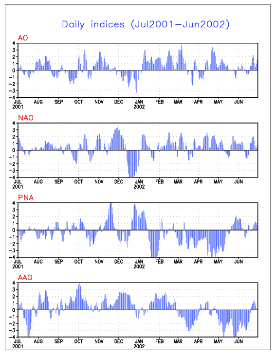
Notice how aside from two strongly positive swings (one in NOV and the other at the end of DEC and beginning of JAN) we observed a very presistent RNA pattern through much of the rest of the winter.
so even in spite of that PAC signal in late december of 2001 we saw a sharp negative turn in the NAO (which had been positive MUCH of the time leading up to that) and the re-alighnment of the pacific pattern allowing a STRONGLY positive PNA ridge to become established in the western part of of north america which in conjunction with the tanking of the NAO one would expect to see a deep trough in the EUS and the vortex become established near hudsons bay supplying cold air...this of course did take place.
the Caveat of couse was olga which sent such rediculous amounts of warm air northward into the polar regions that once the pattern did become established the airmass which came south in response was much warmer than what it SHOULD have been for such a pattern at that time of year.
The GFS ensembles have indicated from some time now the development of the PNA ridge (taking the index from strongly negative to positive in a very short period of time)...
http://www.cpc.ncep.noaa.gov/products/p ... _ensm.html
todays run has been MUCH different from the past few in which the ensemble members do NOT show as sharp of a rise from negative to strongly positive as what they have the past few days. Instead the members would imply the development of a moderately +PNA (0 to +2) which is MUCH more acceptable than its previous ideas.
ONE of the members takes the index to near +3 however appears to be outlier in the solution.
Lets take a look at global SSTA anomalies from 12/26/03:
http://www.osdpd.noaa.gov/PSB/EPS/SST/d ... 6.2003.gif
The cold pool its self is centered further to the southwest...with SOME warm water surrounding it on the northern and eastern sides...closest to coast of AK and western north america.
In 2001/02 when we saw a mostly negative PNA (RNA) (trough in the west...ridge off the southeast coast) the cold pool was centered MUCH further to the northeast...
http://www.osdpd.noaa.gov/PSB/EPS/SST/d ... 9.2001.gif
Notice also there was NO warm water closest to the west coast of North america as there is this year and there is NO warm water near the bering sea to the west of AK as we have this year.
So IOW...the set-up this year is MUCH different than it was in that year...which can lead one to believe that there MAY be more variability in the PNA this year. as long as there is still SOME warm water of the west coast of north america.
Here is the Verification for various global indicies during the 2001/02 winter:
Notice how aside from two strongly positive swings (one in NOV and the other at the end of DEC and beginning of JAN) we observed a very presistent RNA pattern through much of the rest of the winter.
so even in spite of that PAC signal in late december of 2001 we saw a sharp negative turn in the NAO (which had been positive MUCH of the time leading up to that) and the re-alighnment of the pacific pattern allowing a STRONGLY positive PNA ridge to become established in the western part of of north america which in conjunction with the tanking of the NAO one would expect to see a deep trough in the EUS and the vortex become established near hudsons bay supplying cold air...this of course did take place.
the Caveat of couse was olga which sent such rediculous amounts of warm air northward into the polar regions that once the pattern did become established the airmass which came south in response was much warmer than what it SHOULD have been for such a pattern at that time of year.
The GFS ensembles have indicated from some time now the development of the PNA ridge (taking the index from strongly negative to positive in a very short period of time)...
http://www.cpc.ncep.noaa.gov/products/p ... _ensm.html
todays run has been MUCH different from the past few in which the ensemble members do NOT show as sharp of a rise from negative to strongly positive as what they have the past few days. Instead the members would imply the development of a moderately +PNA (0 to +2) which is MUCH more acceptable than its previous ideas.
ONE of the members takes the index to near +3 however appears to be outlier in the solution.
0 likes
-
Stormsfury
- Category 5
- Posts: 10549
- Age: 53
- Joined: Wed Feb 05, 2003 6:27 pm
- Location: Summerville, SC
The PNA indices and the MJO have fairly co-translated (of course, with some lag with sensible weather, but notice WEST of the INT DATE LINE, a very dry running 5-day mean (POS MJO) will be heading east in time. And with that brings VERY INTERESTING TIMES AHEAD.
I don't need to re-iterate that (well yes I do with a quote from HM) but again, very similar in my thoughts from 2 days ago.

SF
HM wrote:THE COLD IS STILL COMING ----- and will make things starting this weekend MORE interesting for the northern 1/2 of CONUS WRT the chance of wintry wx. IT APPEARS the once the front is through, its LES and more PAC energy coming through. BUT THIS TIME w/ REAL arctic air to move into. AT THAT POINT the PV will be moving into SE canada w/ confluence into northeast and midwest/ s canada. THE EURO / ensembles show a vortex retrograding into N PAC which is something that 1) hAS NOT HAPPENED yet this season and 2) will create a VERY convoluted pattern w/ negative EPO pattern. THIS will make for a very wintry period in the eastern 1/2 of the CONUS between JAN 10-20 which hasnt changed and is still being progged by our data.
THE 12z ensembles have 2-3 BIG chances of SECS/MECS in this period b/c of the -NAO signal which all NWP have and the increasingly negative EPO. NOW IF PAC fails to cooperate then of course this doesnt occur BUT I STILL dont understand why everyone is going crazy about winter being over etc etc ...
I don't need to re-iterate that (well yes I do with a quote from HM) but again, very similar in my thoughts from 2 days ago.
SF
0 likes
-
FLguy
- Professional-Met
- Posts: 799
- Joined: Mon Dec 29, 2003 5:36 pm
- Location: Daytona Beach FL
- Contact:
Which would play right into the idea that the cold pool being located further southwest is a more NEUTRAL signal in regard to the EPO and PNA as compared to what it would be IF it was futher to the northeast.
overall its more of a variable signal than one which would favor a presistent RNA pattern.
Once the QBO begins to decrease and head towards its west (or positive) phase the PJ will begin to play a LESS dominating role.
low values (both positive and Negative) of the QBO can also be favorable for major east coast snow events. thus we will have to see how quickly the QBO declines over the next 12 weeks.
0 likes
Who is online
Users browsing this forum: No registered users and 143 guests