So where do we go from here?

Winter Weather Discussion

Moderator: S2k Moderators

Forum rules

The posts in this forum are NOT official forecast and should not be used as such. They are just the opinion of the poster and may or may not be backed by sound meteorological data. They are NOT endorsed by any professional institution or STORM2K.

Help Support Storm2K
Message
Author
User avatar
Erica
Professional-Met
Professional-Met
Posts: 168
Joined: Sat Feb 14, 2004 2:45 am
Location: Daytona Beach, FL
Contact:

So where do we go from here?

#1 Postby Erica » Thu Feb 26, 2004 12:22 am

In the wake of the Southeastern US, and Lower Middle Atlantic, significant snow event, the blocking across the North Atlantic begins to retreat, so the 50/50 low which was in the classic position begins to lift up toward the southern tip of Greenland, turning the NAO positive. At the same time, because the subtropical trough is retrograding back toward the west of Hawaii, both it and the increasingly Positive NAO suggest that the ridge builds into the Eastern part of the country by Sunday.

North America View

http://web.wright-weather.com/wxp-model ... rt_h24.gif
http://web.wright-weather.com/wxp-model ... rt_h48.gif
http://web.wright-weather.com/wxp-model ... rt_h72.gif
http://web.wright-weather.com/wxp-model ... rt_h96.gif

Pacific View

http://web.wright-weather.com/wxp-model ... rt_h24.gif
http://web.wright-weather.com/wxp-model ... rt_h48.gif
http://web.wright-weather.com/wxp-model ... rt_h72.gif
http://web.wright-weather.com/wxp-model ... rt_h96.gif

At the same time, a strong low coming into the Pacific Northwest Thursday and Friday opens up and splits as once piece heads up into Canada, and the second digs into the four corners region and closes off. This also helps to increase the amplitude of the trough in the western part of the country, and therefore, amplifies the ridge downstream.

Because the NAO is positive, there is no 50/50 low, or cold high over the Great lakes, and the strong ridge over the eastern part of the country, the s/w across the four corners region lifts out into the central plains on Monday as the trough tilts negative instead of being forced to take a more suppressed track, making it a threat to the eastern part of the country.

http://web.wright-weather.com/wxp-model ... t_h120.gif
http://web.wright-weather.com/wxp-model ... 20_850.gif
http://web.wright-weather.com/wxp-model ... 20_sfc.gif
http://web.wright-weather.com/wxp-model ... 20_500.gif

So we do know that this week’s event will be a well inland runner, and an all rain event for much of the great lakes, Northeast, New England, and Northern Mid Atlantic. Then as the s/w runs into the building ridge it begins to dampen out (opening up and losing amplitude) as it moves over the Great Lakes on Tuesday. The surface low weakens also as it tracks from the southern plains to the northeastern Great Lakes region Monday into Tuesday.

So after a milder start to the week across the Northeast, the aforementioned system sweeps a cold front across the Great Lakes, Northern Mid Atlantic and New England, on Wednesday, lowering heights, and bringing in slightly colder air.

http://web.wright-weather.com/wxp-model ... t_h168.gif
http://web.wright-weather.com/wxp-model ... 68_850.gif
http://web.wright-weather.com/wxp-model ... 68_500.gif
http://web.wright-weather.com/wxp-model ... 68_sfc.gif

What’s quite interesting though is that, according to the ECMWF, the new s/w sliding down the west coast along the eastern side of the offshore ridge digs in, closes off and eventually separates it’s self (cuts off) from the main flow on Wednesday, which therefore means that it gets held back off the southwest coast of California until something comes along to push it out. This as the NAO remains positive, and the sub-tropical trough is located directly north of Hawaii.

http://web.wright-weather.com/wxp-model ... t_h168.gif
http://web.wright-weather.com/wxp-model ... 68_500.gif

Meanwhile in Europe, the trough is progressing out of Scandinavia, and heights are rising across the western part of the continent as the Azores high intensifies (associated with the Positive NAO). So, we lose not only the signal for the trough in the east perpetuated by a negative NAO (Since it’s positive) and the teleconnection between the trough in Scandinavia and the trough in the eastern part of the country.

Since we have the input from the Cahirs ridge to push cross-polar air onto our side of the pole, we would then want to try to see where the mean trough sets up in order to determine where that air would go. Many of the critical teleconnections (NAO, PNA, location of the sub-tropical trough in relationship to Hawaii, and Scandinavia Pattern) suggest that the trough is in the western part of North America, and the Southeast ridge is going away no time soon.

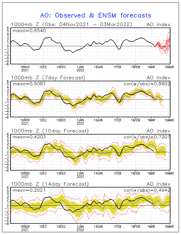
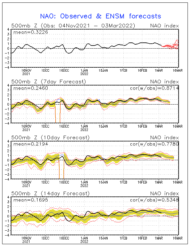
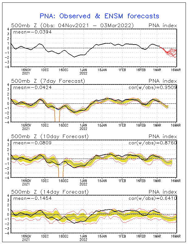
Here are the GFS ensemble representations of the trends in the AO, NAO, and PNA over the next 15 days.

PNA
Image

AO
Image

NAO
Image

The GFS ensembles don’t appear to be in good agreement with the past few runs of the operational ECMWF, as they continue to show a mostly negative NAO over the remainder of the period (only slight trends toward positive). The ensembles also suggest a mostly negative AO (which is correct if the rex blocking scenario comes to fruition) and increasingly positive PNA, especially toward the end of the period.

If the trough is to come back into the east over the next 10 days, and the southeast ridge flatten against the ECMWF representation of the critical teleconnections, the energy that cuts off over the southwest around the middle of next week (providing that it’s not more progressive, since the ECMWF can at times have trouble with holding things like this back) the polar get would not be able to amplify into the west, and would instead be directed southeast over top of it, developing a weak trough in the eastern part of the country and flattening the southeast ridge. All the while, the polar vortex remains across north central Canada and western Baffin Island.

http://web.wright-weather.com/wxp-model ... t_h168.gif

By this time, the Cahirs connection will have done its job in sending a fairly strong cross polar air mass into far northern Canada, however with no real amplification of the pattern here in North America toward mid week; it stays up across northern Canada.

http://web.wright-weather.com/wxp-model ... 68_850.gif

By the end of the period (day 10) we notice the positive height anomaly along the north shore of Alaska earlier on breaks off and begins to track toward the North Pole, helping the vortex to stay put along the north shore of Hudson Bay. The trough is centered across the northern Midwest, but the southeast ridge which earlier on was quite amplified is now more of a flat ridge, and heights are nowhere near as high across the northeast as what they were earlier on in the week. Later on, as the SOI turns negative, the sub-tropical trough near or west of Hawaii should get pushed back to the east of Hawaii, and the energy held back (if it’s held back) across the southwest comes out, making things interesting after the 5th. Especially since we have all the cross polar air up in Canada that can get involved given amplification, possibly having a big impact after March 7th.

http://web.wright-weather.com/wxp-model ... 40_500.gif

Overall to summarize the theme of the next 10 days is the trough is in the western part of the country, the early week system weakens as it lifts toward the Great Lakes and encounters the building ridge in the east, and ends the milder pattern by Wednesday and Thursday as a moderate cold front pushes through the region. After that it’s back to normal or slightly below normal temperatures. But no major snow events for anyone, following this week’s event in the Carolinas, and southeast.

If a major March Nor’easter/winter storm is to occur it would probably do so between the 10th and 20th of the month. Post later tomorrow night on that, if I have some extra time.
0 likes   

User avatar
JCT777
Category 5
Category 5
Posts: 6251
Joined: Mon Oct 14, 2002 9:21 am
Location: Spring Mount, PA
Contact:

#2 Postby JCT777 » Thu Feb 26, 2004 9:36 am

Thanks for the update, Erica. LC's newsletter this morning basically discussed the same ideas - trough on the west, ridge in the east for the next 10 days. Hopefully, there will be one more chance for a snowstorm beyond day 10.
0 likes   

Steve H.
Category 5
Category 5
Posts: 2146
Joined: Sat Oct 19, 2002 9:06 am
Location: Palm Bay, Florida

#3 Postby Steve H. » Thu Feb 26, 2004 10:02 am

Agree Erica. Pattern and models don't offer anything exciting during the next 10 days, but I think we will see a couple of coastal (east) storms before winters end. I do believe there is some credence to what happens in December winter will remember. But being here in Florida as well, I look forward to the summer tropical season :wink: Bring on June 8-)
0 likes   

User avatar
Stephanie
S2K Supporter
S2K Supporter
Posts: 23843
Age: 63
Joined: Thu Feb 06, 2003 9:53 am
Location: Glassboro, NJ

#4 Postby Stephanie » Thu Feb 26, 2004 10:50 am

Thanks for your discussion Erica. The forecast highs for next week in my area is in the 50's, so that goes along with what you are saying.

I know that the snowbirds are hoping for another good snowstorm to end the season with a bang, but I'm kind of glad that there will be a trough in the west. They need the moisture there.
0 likes   

User avatar
Erica
Professional-Met
Professional-Met
Posts: 168
Joined: Sat Feb 14, 2004 2:45 am
Location: Daytona Beach, FL
Contact:

#5 Postby Erica » Thu Feb 26, 2004 6:20 pm

JCT777 wrote:Thanks for the update, Erica. LC's newsletter this morning basically discussed the same ideas - trough on the west, ridge in the east for the next 10 days. Hopefully, there will be one more chance for a snowstorm beyond day 10.


There's actually two periods that I'm looking at. The first is the March 5-9 Timeframe, and the second, in the 10-15 period.
0 likes   

User avatar
Chris the Weather Man
Category 2
Category 2
Posts: 746
Joined: Fri Dec 12, 2003 9:49 pm
Location: NJ

#6 Postby Chris the Weather Man » Thu Feb 26, 2004 7:26 pm

5-9th, and 10-15th.............. Do I see 2 great storms? that happened in that time frame? Ahh yes, 1993, and 1888! March 10-15th timeframe!

Could this be our Snowy March, we have all been wating for?
0 likes   

Anonymous

#7 Postby Anonymous » Thu Feb 26, 2004 8:02 pm

If you are fortunate enough to live in southern Virginia, you do not need a snowy March. They got clobbered today---Again!!

Wow---I live in a Snow Bubble here in NE Virginia.


-Jeb
0 likes   

Guest

#8 Postby Guest » Thu Feb 26, 2004 8:17 pm

Jeb wrote:If you are fortunate enough to live in southern Virginia, you do not need a snowy March. They got clobbered today---Again!!

Wow---I live in a Snow Bubble here in NE Virginia.


-Jeb


You and me both Jeb!!!!!!Sitting at about 16 inches below normal for the season here so far!

Great post as always Erica! Lets not write winter off just yet. I will admit i am looking forward to the 50s almost 60 this weekend.
0 likes   

weatherfan
Tropical Depression
Tropical Depression
Posts: 89
Joined: Wed Dec 17, 2003 7:50 pm

#9 Postby weatherfan » Thu Feb 26, 2004 8:18 pm

Good post your thinking is pretty close to HM on the dates to watch out on.There has been a pretty big disagreement with Dt veres HM and a few otthers about the March pattern.Dt feels winter is over for the east coast and seems to think forecasters releyes on the NAO to much sometimes.While on the other hand HM and a few others feel that we are going to have one last bount of winter before its over 10-20 periold.So its diffetey going to be very interisting to see whos right.So we will see how it all works out.
0 likes   

User avatar
Chris the Weather Man
Category 2
Category 2
Posts: 746
Joined: Fri Dec 12, 2003 9:49 pm
Location: NJ

#10 Postby Chris the Weather Man » Thu Feb 26, 2004 8:55 pm

HM, has Been Right all winter....... and As For DT, He has been right as well..
0 likes   

User avatar
Erica
Professional-Met
Professional-Met
Posts: 168
Joined: Sat Feb 14, 2004 2:45 am
Location: Daytona Beach, FL
Contact:

#11 Postby Erica » Fri Feb 27, 2004 12:00 am

weatherfan wrote:Good post your thinking is pretty close to HM on the dates to watch out on.There has been a pretty big disagreement with Dt veres HM and a few otthers about the March pattern.Dt feels winter is over for the east coast and seems to think forecasters releyes on the NAO to much sometimes.While on the other hand HM and a few others feel that we are going to have one last bount of winter before its over 10-20 periold.So its diffetey going to be very interisting to see whos right.So we will see how it all works out.


I don't think winter is over for the east coast until at least the first week of April. South of Richmond, however, it may be, but further north no.

Winters with a transitional QBO like 1996-97 and weak ENSO warm conditions that develop late in the season can occur in just enough time to have an effect on things. The 1981-82 winter was also a pretty good example, but the QBO remained east the entire season, strongly so, even into April. So it may not be the best analog.

In 1997, the QBO reversed between January and February, as El Nino conditions began to develop in the tropical Pacific, just in enough time to force changes in the pattern that lead to the March 31-April 1, major east coast snowstorm.

Here's a comparison of global SSTA in April 1982, and March 1997. Both of those months in those years featured major east coast snowstorms.

Image

Image

This year the QBO is reversing around the same time, but El Nino conditions still fail to become established, although, we are approaching borderline, especially in the 4.0 region.

Image

Now if we assume that March-April 1997 is the best analog to this year, we would expect the major event to occur around the same time. Or is it?

We all know that low QBO values within +/- 5.00 of neutral, and especially in the westerly phase are especially favorable for major east coast snowstorms, and with that also comes a relaxation of the polar jet, and more blocking, and a better chance for the establishment of a sustained Positive PNA pattern.

The Rex blocking setting up this coming week as the positive height center breaks away from Alaska's arctic coast, and heads toward the north pole, the polar vortex and all the cross polar air which gets pushed onto our side of the pole as a result of the Cahirs ridge, will stay up in Canada in proximity to the vortex until sufficient amplification occurs to draw it into the pattern here in the United States.

Anytime your looking for a major march winter storm for the eastern half of the nation, having cross polar air up in Canada which given (in the extreme case) three stream phasing, can be tapped and drawn in, helping to enhance the wintry aspect of the system.

That's all well and good but at this time of the year since heights globally are increasing and the westerlies are beginning to lift according to the seasonal variation, a Negative NAO, and 50/50 low are ever so critical.

In short, I would be shocked if this pattern yields nothing of significance for the eastern part of the country given the increasingly favorable global indices.
0 likes   

User avatar
JCT777
Category 5
Category 5
Posts: 6251
Joined: Mon Oct 14, 2002 9:21 am
Location: Spring Mount, PA
Contact:

#12 Postby JCT777 » Fri Feb 27, 2004 9:17 am

Great post, Erica. It is giving me some hope in the face of many other forecasts (LC, DT, Louwxman and a few others I have heard) which seem to indicate the mild weather will be in the east to stay beginning this weekend.
0 likes   

Steve H.
Category 5
Category 5
Posts: 2146
Joined: Sat Oct 19, 2002 9:06 am
Location: Palm Bay, Florida

#13 Postby Steve H. » Fri Feb 27, 2004 2:36 pm

Don't think winter is over in the East yet, heck its February 27th! To ay that is absurd, even with some confidence in the pattern which, BTW, there isn't totally. Given some of the model disagreement during the past 2 weeks, thinking that there will be a return to normal or slightly below by day 10 in the NE, and the weather will cycle through warm and cold periods, which is typical for March. Question is will SW trough reload or not as the low progresses into the rockies next week, an how deep does it get. As pointed out in the HPC disco today, GFS showed a disagreement with the EC as to where the polar vortex goes next week. Let's watch to see if future runs keep it further swd with less SE ridging during the MR. March is a month of quick changes and we ain't there yet! Still think that late next week has potential for snow in the NE. And maybe another shot the week after. Cheers!!
0 likes   

User avatar
Colin
Category 5
Category 5
Posts: 5086
Joined: Fri Apr 18, 2003 4:17 pm
Location: Catasauqua, PA
Contact:

#14 Postby Colin » Fri Feb 27, 2004 2:53 pm

I hope we get a major March storm...but I am enjoying the springlike temps!
0 likes   

Guest

#15 Postby Guest » Fri Feb 27, 2004 3:16 pm

folks its over... said 5 days ago... still say it.

LONG over

even JB gave up
0 likes   

User avatar
Stephanie
S2K Supporter
S2K Supporter
Posts: 23843
Age: 63
Joined: Thu Feb 06, 2003 9:53 am
Location: Glassboro, NJ

#16 Postby Stephanie » Fri Feb 27, 2004 3:46 pm

I'm looking forward to this weekend's temps as well!
0 likes   


Return to “Winter Weather”

Who is online

Users browsing this forum: No registered users and 6 guests