Pacific Northwest: April 2005 Precipitation Idea

Winter Weather Discussion

Moderator: S2k Moderators

Forum rules

The posts in this forum are NOT official forecast and should not be used as such. They are just the opinion of the poster and may or may not be backed by sound meteorological data. They are NOT endorsed by any professional institution or STORM2K.

Help Support Storm2K
Message
Author
donsutherland1
S2K Analyst
S2K Analyst
Posts: 2718
Joined: Mon Sep 15, 2003 8:49 pm
Location: New York

Pacific Northwest: April 2005 Precipitation Idea

#1 Postby donsutherland1 » Fri Mar 18, 2005 10:50 am

A number of factors suggests that the Pacific Northwest (Oregon, Washington, and British Columbia) will likely see normal to above normal precipitation during April.

ENSO Climatology:

Since 1950, 6/8 (75%) of weak El Niño winters were followed by normal to above normal precipitation in April. 5/8 (63%) of such winters saw above normal precipitation.

In addition, 4/5 (80%) of such winters that experienced a positive PDO during April saw normal or above normal precipitation. 3/5 (60%) received above normal precipitation.

Southern Oscillation Index:

In recent weeks, the SOI has risen sharply. In cases where the March average rose 8 or more points from the February average and April averaged negative, 5/8 (63%) saw normal or above normal precipitation in April. When the PDO averaged positive, 3/4 (75%) saw normal or above normal precipitation.

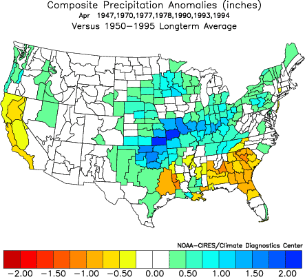
Composite Precipition Anomalies for Years Falling Under Either of the Above Categories:

Image

Key Assumptions:

• The PDO will likely average positive in April: Since 1900, 45/53 (85%) of cases that saw a positive PDO in February, also saw a positive PDO in April. Even more impressive, in 24/25 (96%) cases that saw the February PDO average +0.80 or above, the PDO averaged positive in April.

The latest PDO information is for February 2005. The PDO stood at +0.81 in February.

• The SOI will likely average negative in April: Since 1876, there have been 32 cases where the monthly SOI average rose by 6 or more points in March. In just 1/32 (3%) case, it rose by 8 or more points in April. In just 2/32 (6%) cases, it rose by 5 or more points in April. In the remaining 30/32 (94%) cases, it rose by less than 5 points or fell during April.

If the SOI is to average positive for April, it will likely need to increase by 8 or more points in April. The historical odds are strongly against such a scenario.
0 likes   

User avatar
W13
Category 5
Category 5
Posts: 1938
Joined: Sun Jul 18, 2004 2:46 pm
Location: Kent, Washington

#2 Postby W13 » Sat Mar 19, 2005 12:30 pm

Great post, Don! :)

I hope we have above-normal precipitation in April, since we need it very badly. If we don't, then the drought will be official. If we get a lot of precip, then maybe the drought will settle-down for a little while.
0 likes   

donsutherland1
S2K Analyst
S2K Analyst
Posts: 2718
Joined: Mon Sep 15, 2003 8:49 pm
Location: New York

#3 Postby donsutherland1 » Sat Mar 19, 2005 1:03 pm

W13,

At this point, some of the model guidance is looking encouraging for the start of what could be a wet period (late March through April). It will be interesting to look back at the end of April to see how things worked out.
0 likes   

snow_wizzard
Category 4
Category 4
Posts: 994
Joined: Mon Jan 17, 2005 12:15 am
Location: Covington, WA

#4 Postby snow_wizzard » Sat Mar 19, 2005 8:56 pm

Awsome news Don! It sure looks like things have already begun to get wetter around here. It looks like we might get out of this drought by the skin of our teeth! :)

By the way...Do you think a strong zonal flow would be favorable to shift the PDO to negative (at least get cold water to the west coast)? The reason I ask is because there is a huge pool of cold water in the central Pacific that could easily be pushed eastward. Also...How do you explain the cold winters the Pacific NW had in the 1928 to 1937 time frame? That was a strong positive PDO period and yet there was some wickedly cold weather in there, especially Jan - Feb 1929, Feb 1933, Feb 1936, and Jan 1937.
0 likes   

donsutherland1
S2K Analyst
S2K Analyst
Posts: 2718
Joined: Mon Sep 15, 2003 8:49 pm
Location: New York

#5 Postby donsutherland1 » Sun Mar 20, 2005 5:14 pm

Snow_Wizard,

The PDO is just one factor, albeit an important one, in helping shape winter weather across North America. Unfortunately, most of the global indices i.e., MEI, detailed ENSO regional data, etc., are not available priot to 1948 or 1950. This makes it difficult to pin down why those particular winters differed from the norm. Of course, some PDO+ winters have done very well in the Pacific Northwest.
0 likes   

donsutherland1
S2K Analyst
S2K Analyst
Posts: 2718
Joined: Mon Sep 15, 2003 8:49 pm
Location: New York

Re: Pacific Northwest: April 2005 Precipitation Idea

#6 Postby donsutherland1 » Mon Mar 28, 2005 9:26 am

The weekend saw 2.15" of rain at Seattle. This bring's the monthly figure close to normal for March. I believe that the dramatic increase in rainfall across the Pacific Northwest marks the beginning of wetter April pattern discussed at the beginning of this thread.
0 likes   

TT-SEA

#7 Postby TT-SEA » Mon Mar 28, 2005 9:42 am

Yep... it looks like we are starting to reduce the threat of drought.

We had good soaking rains all over Western Washington this weekend and 14-20 inches of snow in the local mountains.

It is raining here now and snowing in the mountains again.
0 likes   

donsutherland1
S2K Analyst
S2K Analyst
Posts: 2718
Joined: Mon Sep 15, 2003 8:49 pm
Location: New York

Re: Pacific Northwest: April 2005 Precipitation Idea

#8 Postby donsutherland1 » Tue Apr 05, 2005 10:15 am

April Gets Off to Wet Start in the Pacific Northwest

The first three days of April saw 0.84" rain fall in Seattle. That is nearly one-third of the normal monthly figure. Moreover, it surpasses the April 2004 total of 0.65". Over the next 10-14 days, additional rainfall appears highly likely and the total amount could be significant.
0 likes   

donsutherland1
S2K Analyst
S2K Analyst
Posts: 2718
Joined: Mon Sep 15, 2003 8:49 pm
Location: New York

Re: Pacific Northwest: April 2005 Precipitation Idea

#9 Postby donsutherland1 » Wed Apr 13, 2005 10:45 am

Another week has passed and Seattle's monthly rainfall has continued to increase. Through April 12, April rainfall totaled 1.85". That's just over 70% of the normal figure for the entire month. All in all, things appear to be on track.
0 likes   

donsutherland1
S2K Analyst
S2K Analyst
Posts: 2718
Joined: Mon Sep 15, 2003 8:49 pm
Location: New York

Re: Pacific Northwest: April 2005 Precipitation Idea

#10 Postby donsutherland1 » Sat Apr 16, 2005 12:05 pm

As of 8 am PDT, Seattle had received 0.41" of rain. That put the monthly figure at 2.65", which is above the monthly norm of 2.59."
0 likes   

donsutherland1
S2K Analyst
S2K Analyst
Posts: 2718
Joined: Mon Sep 15, 2003 8:49 pm
Location: New York

Re: Pacific Northwest: April 2005 Precipitation Idea

#11 Postby donsutherland1 » Sun May 01, 2005 11:03 am

Final April 2005 precipitation tally for Seattle: 3.68" (1.09" above normal).
0 likes   


Return to “Winter Weather”

Who is online

Users browsing this forum: No registered users and 11 guests