Winter 2010-11 for the Southern Plains

Winter Weather Discussion

Moderator: S2k Moderators

Forum rules

The posts in this forum are NOT official forecast and should not be used as such. They are just the opinion of the poster and may or may not be backed by sound meteorological data. They are NOT endorsed by any professional institution or STORM2K.

Help Support Storm2K
Message
Author
User avatar
somethingfunny
ChatStaff
ChatStaff
Posts: 3926
Age: 35
Joined: Thu May 31, 2007 10:30 pm
Location: McKinney, Texas

Re: Winter 2010-11 for the Southern Plains

#101 Postby somethingfunny » Tue Oct 19, 2010 1:00 am

somethingfunny wrote:ImageImageImage

I'll mark my calendar. October 18!


Sorely disappointed. :(
0 likes   
I am not a meteorologist, and any posts made by me are not official forecasts or to be interpreted as being intelligent. These posts are just my opinions and are probably silly opinions.

User avatar
Extremeweatherguy
Category 5
Category 5
Posts: 11095
Joined: Mon Oct 10, 2005 8:13 pm
Location: Houston, TX

Re: Winter 2010-11 for the Southern Plains

#102 Postby Extremeweatherguy » Tue Oct 19, 2010 12:05 pm

As expected, the snowy model solutions for the southern plains to end the month have disappeared. However, the latest run of the GFS does continue to indicate a big (and welcomed) pattern change on the way starting in about 6-7 days. Beginning early next week it shifts us into a much more active front pattern, with several stronger cold fronts moving into the area through the end of the month and into November. If this pattern does indeed pan out, then it might finally begin to feel more like mid-autumn, and frost and freeze threats into northern parts of the southern plains (Oklahoma, N. Texas) could be possible in the day 7 to 16 range.

The 00z ECMWF also seems to agree with this pattern change idea, sending a large trough into the central and eastern United States between October 27th and 29th.

Update: The 12z ECMWF now has the trough centered more over the western/central United States by the end of the month, with a strong front pushing down the plains and into our region (OK/TX) by October 28th/29th.
0 likes   

User avatar
Extremeweatherguy
Category 5
Category 5
Posts: 11095
Joined: Mon Oct 10, 2005 8:13 pm
Location: Houston, TX

#103 Postby Extremeweatherguy » Wed Oct 20, 2010 3:20 pm

Today's GFS and ECMWF runs continue to be supportive of a shift to a cooler weather pattern starting mid/late next week.

Below is a look at both model's depictions of the first in a series of decent troughs to move into the region during the late October/early November time period (assuming the general idea from the guidance holds). This one in particular is depicted as arriving in 7-8 days, and while some changes are still likely, the models are surprisingly in fantastic agreement right now:

GFS (12z)

168 hrs - Wed 10/27
Image

192 hrs - Thurs 10/28
Image

216 hrs - Fri 10/29
Image


ECMWF (12z)

168 hrs - Wed 10/27
Image

192 hrs - Thurs 10/28
Image

216 hrs - Fri 10/29
Image
0 likes   

Ntxw
Storm2k Moderator
Storm2k Moderator
Posts: 21565
Joined: Wed Oct 21, 2009 6:34 pm
Location: DFW, Texas

#104 Postby Ntxw » Wed Oct 20, 2010 8:03 pm

^ I think it's not totally out of the question that much of Oklahoma could be experiencing the first widespread freeze at the end of this month and early Nov. Until then looks like warm/somewhat humid north and warmer humid south conditions should continue per GFS/EC.
0 likes   
The above post and any post by Ntxw is NOT an official forecast and should not be used as such. It is just the opinion of the poster and may or may not be backed by sound meteorological data. It is NOT endorsed by any professional institution including Storm2k. For official information, please refer to NWS products.

  Help support Storm2K!
Help Support Storm2K

User avatar
Extremeweatherguy
Category 5
Category 5
Posts: 11095
Joined: Mon Oct 10, 2005 8:13 pm
Location: Houston, TX

Re: Winter 2010-11 for the Southern Plains

#105 Postby Extremeweatherguy » Sat Oct 23, 2010 1:12 am

Well unfortunately both the GFS and ECMWF have backed off on the intensity of the cold airmass arriving later next week, now just showing a weak/moderate late October cold front. If the models don't start trending colder again over the next few days, then it looks like we might have to wait a little while longer before we see our first widespread freeze threat across the southern plains.
0 likes   

User avatar
amawea
S2K Supporter
S2K Supporter
Posts: 385
Age: 72
Joined: Mon Aug 09, 2004 3:36 pm
Location: Horseshoe Bend, Ar. but from Baytown, Tx

Re: Winter 2010-11 for the Southern Plains

#106 Postby amawea » Sat Oct 23, 2010 8:36 am

Well unfortunately both the GFS and ECMWF have backed off on the intensity of the cold airmass arriving later next week, now just showing a weak/moderate late October cold front. If the models don't start trending colder again over the next few days, then it looks like we might have to wait a little while longer before we see our first widespread freeze threat across the southern plains.


Yep Extremeweatherguy, the discussion out of Springfield, Mo. actually talks about a slight warm up at the end of next week. Two days ago they were talking a freeze. :(
0 likes   

User avatar
Extremeweatherguy
Category 5
Category 5
Posts: 11095
Joined: Mon Oct 10, 2005 8:13 pm
Location: Houston, TX

Re: Winter 2010-11 for the Southern Plains

#107 Postby Extremeweatherguy » Sat Oct 23, 2010 6:58 pm

The 12z and 18z GFS and the 12z ECMWF have trended back slightly cooler today for the late week front. Still not as cold as it once looked, but at least the warming trend in the models seems to have ended for now. All in all, this is shaping up to be a moderate October front. Enough to knock temperatures to near or slightly below normal for a few days, but nothing unusual or overly cold (compared to averages). Could see a frost threat for areas north of Red River if a night of good radiational cooling develops, but for late October such a scenario is not really too uncommon.
0 likes   

User avatar
Extremeweatherguy
Category 5
Category 5
Posts: 11095
Joined: Mon Oct 10, 2005 8:13 pm
Location: Houston, TX

#108 Postby Extremeweatherguy » Tue Oct 26, 2010 4:27 pm

Image
0 likes   

User avatar
TwisterFanatic
Category 5
Category 5
Posts: 1041
Joined: Mon Jun 28, 2010 12:43 pm
Location: Sallisaw, Oklahoma

#109 Postby TwisterFanatic » Wed Oct 27, 2010 7:03 pm

Watching the weather today and they said possibly major cold blast next Tuesday or Wednesday. Highs might not get into the 50's.
0 likes   
Personal Forecast Disclaimer:
The posts in this forum are NOT official forecast and should not be used as such. They are just the opinion of the poster and may or may not be backed by sound meteorological data. They are NOT endorsed by any professional institution or storm2k.org. For official information, please refer to the NHC and NWS products.

User avatar
Extremeweatherguy
Category 5
Category 5
Posts: 11095
Joined: Mon Oct 10, 2005 8:13 pm
Location: Houston, TX

Re:

#110 Postby Extremeweatherguy » Wed Oct 27, 2010 9:01 pm

TwisterFanatic wrote:Watching the weather today and they said possibly major cold blast next Tuesday or Wednesday. Highs might not get into the 50's.
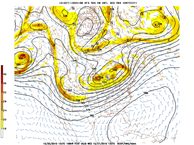
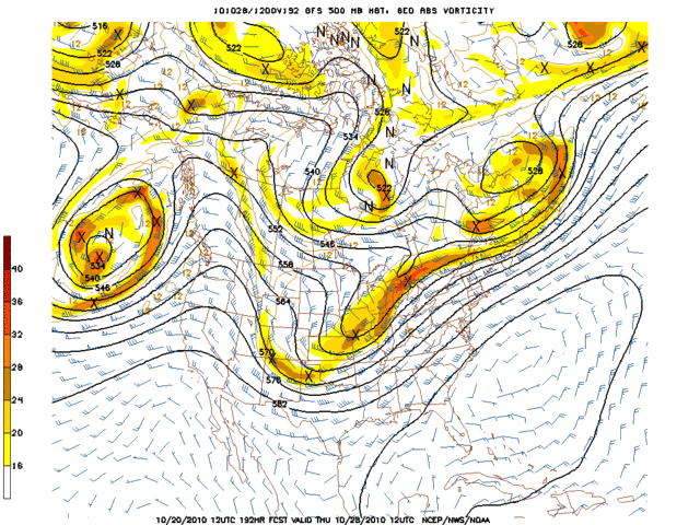
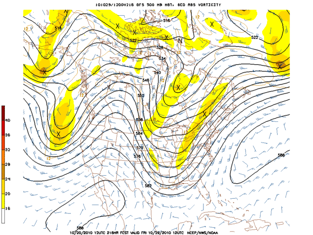
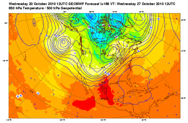
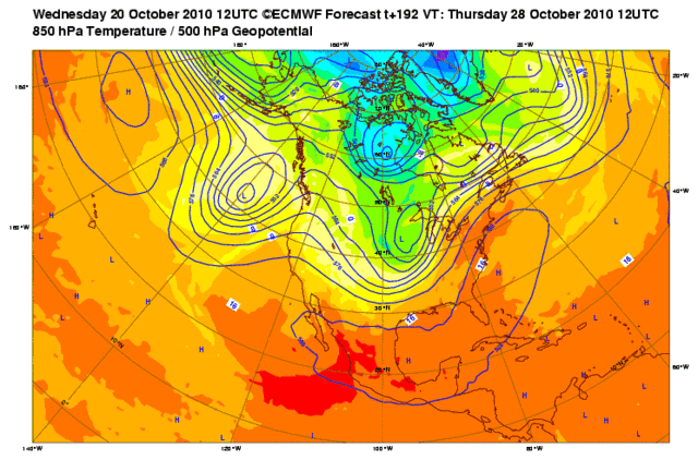
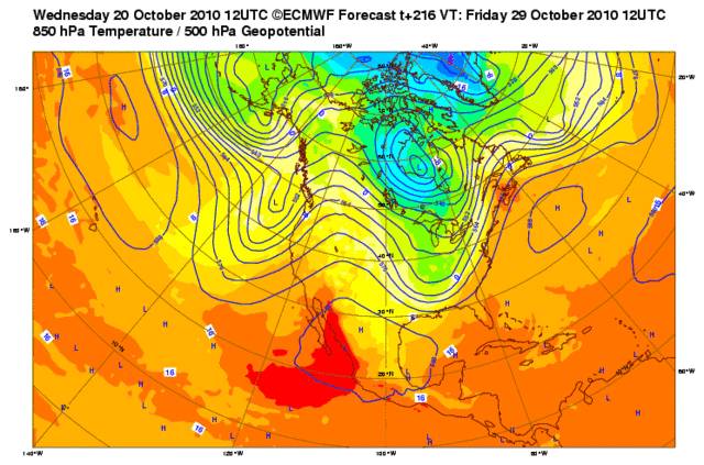
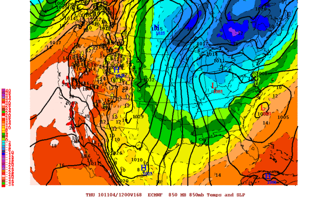
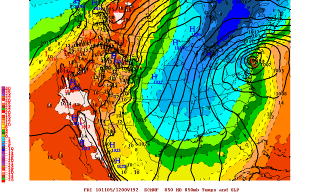
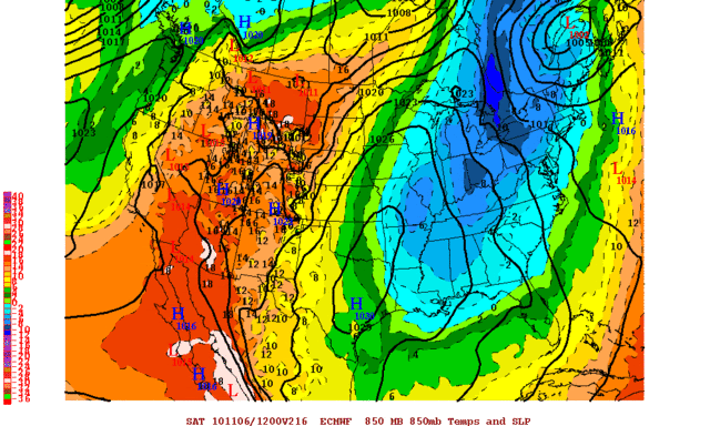
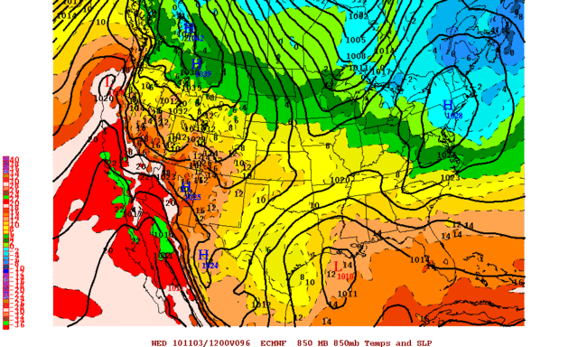
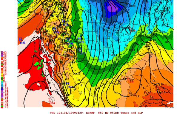
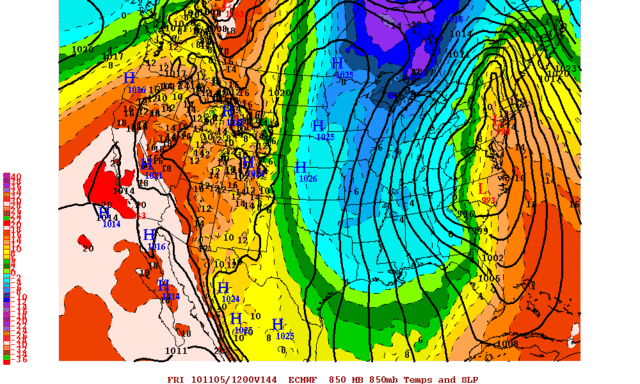
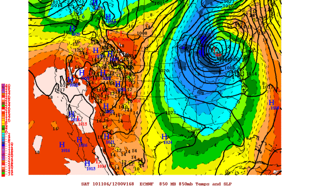
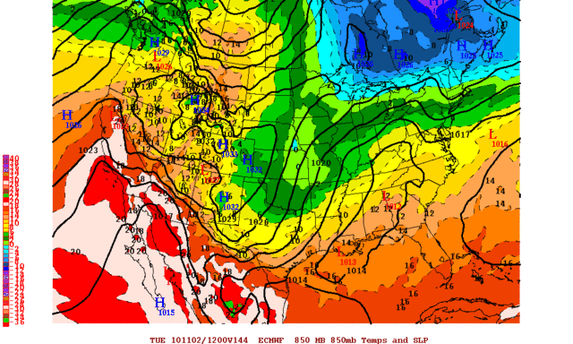
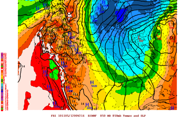
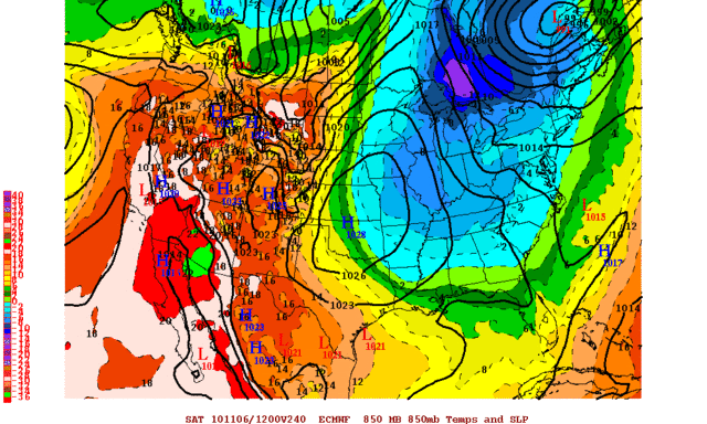
There are some indications of a more significant cold shot next week, but details are still not tied down on exactly how/when (or even if) it will play out. The ECMWF, for instance, brings down a moderate shot of cold early in the week ( http://i43.photobucket.com/albums/e371/ ... PUS144.gif ), followed by a much stronger shot of cold for the eastern 1/2 of the USA by the end of the week ( http://i43.photobucket.com/albums/e371/ ... PUS216.gif ). The brunt of this later cold wave is centered more to our east, but if the ECMWF depiction of the surface high settling right over Oklahoma is correct ( http://i43.photobucket.com/albums/e371/ ... PUS240.gif ), then the first widespread freeze/hard freeze of the season could be possible across the area under favorable nighttime radiational cooling conditions.

The (18z) GFS looks warmer than the ECMWF, showing fairly mild conditions across most of the country during the same period that the ECMWF looks chilly. If it is correct, then temperatures would be much closer to average late next week.

Update - Unfortunately, the 00z ECMWF has trended warmer for late next week.
Last edited by Extremeweatherguy on Thu Oct 28, 2010 10:51 am, edited 1 time in total.
0 likes   

User avatar
Extremeweatherguy
Category 5
Category 5
Posts: 11095
Joined: Mon Oct 10, 2005 8:13 pm
Location: Houston, TX

Re: Winter 2010-11 for the Southern Plains

#111 Postby Extremeweatherguy » Thu Oct 28, 2010 10:45 am

We're expecting the coldest morning so far this season here in the OKC vicinity tomorrow morning. The forecast is currently calling for mid 30s around the area with frost likely, which would beat the previous coldest reading of 37F experienced earlier in the month.

Image
Last edited by Extremeweatherguy on Thu Oct 28, 2010 5:41 pm, edited 1 time in total.
0 likes   

User avatar
Extremeweatherguy
Category 5
Category 5
Posts: 11095
Joined: Mon Oct 10, 2005 8:13 pm
Location: Houston, TX

Re: Winter 2010-11 for the Southern Plains

#112 Postby Extremeweatherguy » Thu Oct 28, 2010 5:40 pm

Today's 12z run of the ECMWF is back to a very chilly look for mid to late next week. In fact, for the southern plains in particular, this is the coldest run we have seen so far. If something like what is depicted actually plays out, then we could easily be looking a period of below normal temperatures to end next week, with a widespread freeze threat (several degrees colder than tonight) for the northern half of the southern plains.

ECMWF 850mb temperature/sea-level pressure maps for mid/late next week:

WED MORNING (144 hrs)
Image

THURS MORNING (168 hrs)
Image

FRI MORNING (192 hrs)
Image

SAT MORNING (216 hrs)
Image

Well the ECMWF keeps going back and forth. The 00z run is back to showing most of the cold air heading to our east.
0 likes   

NY NJ PA Weather
Professional-Met
Professional-Met
Posts: 22
Age: 44
Joined: Fri Sep 10, 2010 9:39 am
Location: Freehold, New Jersey
Contact:

Re: Winter 2010-11 for the Southern Plains

#113 Postby NY NJ PA Weather » Fri Oct 29, 2010 10:11 am

The models are having problems because of the convection around 180 to 160E, this is causing issues with the various long range models handling the position of the ridge around the Aleutian Islands and thus the changes from run to run on the models. Also, an interesting note is the problem the models are having with forecasting the MJO phases. One goes into PHASE 5, the other PHASE 7/8 which are two completely different patterns.

The key is that convection. The little things DO matter. BTW, snow cover growth is rapidly building over NH, big key indicator for Arctic Air Masses for late November on.
0 likes   
Let the Water Vapor Satellite lead the way!

User avatar
amawea
S2K Supporter
S2K Supporter
Posts: 385
Age: 72
Joined: Mon Aug 09, 2004 3:36 pm
Location: Horseshoe Bend, Ar. but from Baytown, Tx

Re: Winter 2010-11 for the Southern Plains

#114 Postby amawea » Fri Oct 29, 2010 10:17 am

I had 26.8 on my digital weather station here in the boonies of North Arkansas this a.m.
:cold:
0 likes   

User avatar
CaptinCrunch
S2K Supporter
S2K Supporter
Posts: 8580
Age: 56
Joined: Mon Nov 03, 2003 4:33 pm
Location: Lake Worth, TX (Tarrant Co.)

Re: Winter 2010-11 for the Southern Plains

#115 Postby CaptinCrunch » Fri Oct 29, 2010 11:33 am

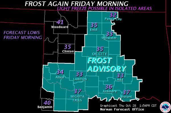
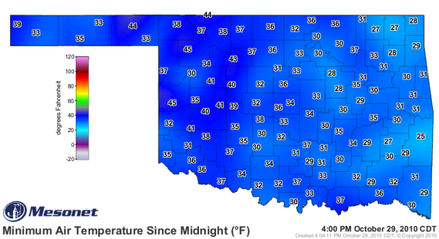
amawea wrote:I had 26.8 on my digital weather station here in the boonies of North Arkansas this a.m.
:cold:


36 this morning at the house in rural Tarrant Co. even had a light frost on the rooftops.
0 likes   

User avatar
TwisterFanatic
Category 5
Category 5
Posts: 1041
Joined: Mon Jun 28, 2010 12:43 pm
Location: Sallisaw, Oklahoma

#116 Postby TwisterFanatic » Fri Oct 29, 2010 12:50 pm

Had a killing freeze this morning. 24 degrees. :cold:
0 likes   
Personal Forecast Disclaimer:
The posts in this forum are NOT official forecast and should not be used as such. They are just the opinion of the poster and may or may not be backed by sound meteorological data. They are NOT endorsed by any professional institution or storm2k.org. For official information, please refer to the NHC and NWS products.

User avatar
Texas Snowman
Storm2k Moderator
Storm2k Moderator
Posts: 6085
Joined: Fri Jan 25, 2008 11:29 am
Location: Denison, Texas

Re: Winter 2010-11 for the Southern Plains

#117 Postby Texas Snowman » Fri Oct 29, 2010 2:42 pm

Upper 30s here in Grayson County. Light frost on the rooftops. Gosh I hope it was enough to end the ragweed season here! :(
0 likes   
The above post and any post by Texas Snowman is NOT an official forecast and should not be used as such. It is just the opinion of the poster and may or may not be backed by sound meteorological data. It is NOT endorsed by any professional institution including storm2k.org. For official information, please refer to NWS products.

User avatar
Extremeweatherguy
Category 5
Category 5
Posts: 11095
Joined: Mon Oct 10, 2005 8:13 pm
Location: Houston, TX

#118 Postby Extremeweatherguy » Fri Oct 29, 2010 4:08 pm

Low temperatures this morning across Oklahoma:

Image

Coldest night of the season so far in my location (33-36F). Enough for frost to cover the cars around sunrise.
0 likes   

Ntxw
Storm2k Moderator
Storm2k Moderator
Posts: 21565
Joined: Wed Oct 21, 2009 6:34 pm
Location: DFW, Texas

#119 Postby Ntxw » Sat Oct 30, 2010 2:18 pm

Today's EC and GFS says BRR next weekend for the southern plains and deep south. 40s for highs anyone?
0 likes   
The above post and any post by Ntxw is NOT an official forecast and should not be used as such. It is just the opinion of the poster and may or may not be backed by sound meteorological data. It is NOT endorsed by any professional institution including Storm2k. For official information, please refer to NWS products.


  Help support Storm2K!

Help Support Storm2K


User avatar
Extremeweatherguy
Category 5
Category 5
Posts: 11095
Joined: Mon Oct 10, 2005 8:13 pm
Location: Houston, TX

Re: Winter 2010-11 for the Southern Plains

#120 Postby Extremeweatherguy » Sat Oct 30, 2010 2:41 pm

The 12z ECMWF run is definitely pretty chilly, and while the GFS is a bit warmer; it too has trended colder recently. I like the idea of a decent cold airmass coming into the nation next week, with the brunt staying to our east, but with a nice taste down the plains. The ECMWF scenario actually looks quite possible, IMO. If such a scenario actually plays out, with the 0C 850mb line dipping all the way to the Gulf Coast, then many from central TX and OK eastward could be in for their coldest readings of the season (so far) by late next week.

I have posted the 12z ECMWF run below for those interested:

Hour 96 - 168 of the 12z ECMWF run (SLP/850mb Temps):

WED MORNING (96 HRS)
Image

THUR MORNING (120 HRS)
Image

FRI MORNING (144 HRS)
Image

SAT MORNING (168 HRS)
Image
0 likes   


Return to “Winter Weather”

Who is online

Users browsing this forum: No registered users and 18 guests