Texas Winter 2014-2015
Moderator: S2k Moderators
Forum rules
 The posts in this forum are NOT official forecast and should not be used as such. They are just the opinion of the poster and may or may not be backed by sound meteorological data. They are NOT endorsed by any professional institution or STORM2K.

The posts in this forum are NOT official forecast and should not be used as such. They are just the opinion of the poster and may or may not be backed by sound meteorological data. They are NOT endorsed by any professional institution or STORM2K.

Re: Texas Winter 2014-2015
Great write up by Jeff. The EPO if it wants cold, it will get cold. You get ridging in Alaska one way or another the only resistance will come from a little patch of warmth huffing and puffing in Houston 
0 likes
The above post and any post by Ntxw is NOT an official forecast and should not be used as such. It is just the opinion of the poster and may or may not be backed by sound meteorological data. It is NOT endorsed by any professional institution including Storm2k. For official information, please refer to NWS products.
Help support Storm2K!
-
Rgv20

- S2K Supporter

- Posts: 2466
- Age: 39
- Joined: Wed Jan 05, 2011 5:42 pm
- Location: Edinburg/McAllen Tx
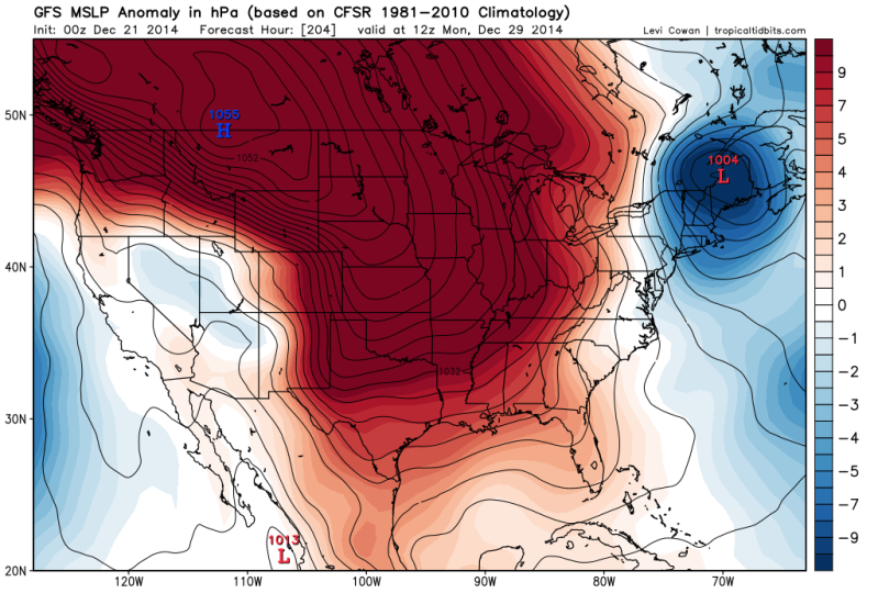
0zGFS Forecast a monster 1055 High Pressure entering Montana next Monday! 

0 likes
The following post is NOT an official forecast and should not be used as such. It is just the opinion of the poster and may or may not be backed by sound meteorological data. It is NOT endorsed by any professional institution including storm2k.org For Official Information please refer to the NHC and NWS products.
-
wxman57

- Moderator-Pro Met

- Posts: 23174
- Age: 68
- Joined: Sat Jun 21, 2003 8:06 pm
- Location: Houston, TX (southwest)
Re: Texas Winter 2014-2015
Here are a few meteograms for Houston from that 00Z GFS. Light freeze around New year's. 06Z GFS is not as cold, once again. Still too far out to have any confidence.


0 likes
Re: Texas Winter 2014-2015
More immediately, 70s are looking less likely to happen on Christmas day given that GFS output. If there's one thing I can't stand it's the warm Christmas we get down here some years.
That extended meteogram from the GFS still looks quite cold with highs in the 40s for a few days 28th - 2nd.
That extended meteogram from the GFS still looks quite cold with highs in the 40s for a few days 28th - 2nd.
0 likes
Joe Bastardi mentioned something about averages for Dallas the past few days so I decided to check. Interesting that the daytime highs since Tuesday have ranged from -4 to -9F below normal. But the overnight lows didn't really fall off much being above normal. That's explained by the persistent virtually nonstop cloud covers. Through the first 20 days DFW has recorded 1 clear day. All others were cloudy, many recording mist or fog.
Happy Winter Solstice!
Happy Winter Solstice!
0 likes
The above post and any post by Ntxw is NOT an official forecast and should not be used as such. It is just the opinion of the poster and may or may not be backed by sound meteorological data. It is NOT endorsed by any professional institution including Storm2k. For official information, please refer to NWS products.
Help support Storm2K!
Help support Storm2K!
-
Portastorm

- Storm2k Moderator

- Posts: 9955
- Age: 63
- Joined: Fri Jul 11, 2003 9:16 am
- Location: Round Rock, TX
- Contact:
Re: Texas Winter 2014-2015
Just adding a little bit to wxman57's post, yes, both the 0z GFS and Euro runs backed off on the magnitude of cold for the post-Christmas period. As we discussed yesterday, the models may struggle a bit in this timeframe with consistency.
Using an old adage from wxman57 himself, we should be paying more attention to the progged 500mb features and pattern anyhow as the surface features will work themselves out closer to the period of focus.
Using an old adage from wxman57 himself, we should be paying more attention to the progged 500mb features and pattern anyhow as the surface features will work themselves out closer to the period of focus.
0 likes
Any forecasts under my name are to be taken with a grain of salt. Get your best forecasts from the National Weather Service and National Hurricane Center.
-
northjaxpro

- S2K Supporter
- Posts: 8900
- Joined: Mon Sep 27, 2010 11:21 am
- Location: Jacksonville, FL
Re:
Rgv20 wrote:0zGFS Forecast a monster 1055 High Pressure entering Montana next Monday!
Yeah, just the type of massive Arctic High you anticipate seeing in major arctic outbreaks. They build down out of Western Canada and come down into Montana often, as shown on this GFS run and into the Intermountain West and down the spine of the Rockies. Should that Arctic High verify at 1055 mb, just the sheer strength of that Arctic High will cause the arctic air to spead down like molasses, first down through the Plains and into Texas and eventually eastward.
0 likes
NEVER, EVER SAY NEVER in the tropics and weather in general, and most importantly, with life itself!!
________________________________________________________________________________________
Fay 2008 Beryl 2012 Debby 2012 Colin 2016 Hermine 2016 Julia 2016 Matthew 2016 Irma 2017 Dorian 2019
________________________________________________________________________________________
Fay 2008 Beryl 2012 Debby 2012 Colin 2016 Hermine 2016 Julia 2016 Matthew 2016 Irma 2017 Dorian 2019
-
Portastorm
- Storm2k Moderator
- Posts: 9955
- Age: 63
- Joined: Fri Jul 11, 2003 9:16 am
- Location: Round Rock, TX
- Contact:
Re: Texas Winter 2014-2015
Well, this from the 12z GFS op run today. It's the progged 500mb pattern at 6 p.m. on December 30th looking about as conducive for an Arctic airmass into the Southern Plains/Texas as it can get. Ridge along the West Coast, a deep low just above the Great Lakes ... yeah, whatever kinda air is up at the North Pole around this timeframe is coming south.
Oh yeah and notice the more active STJ with upper level energy approaching southern California!

Oh yeah and notice the more active STJ with upper level energy approaching southern California!
0 likes
Any forecasts under my name are to be taken with a grain of salt. Get your best forecasts from the National Weather Service and National Hurricane Center.
Re: Texas Winter 2014-2015
The 12z GFS has a 1054mb high in Montana @ 216 hrs and actually builds the high up to 1058mb by the time it gets to the Colorado/Wyoming border. Those forecast temps are down also, though not as extreme as depicted before. Shows a high of 35F on New Year's day for IAH, with lows 27-28.
0 likes
-
Rgv20
- S2K Supporter
- Posts: 2466
- Age: 39
- Joined: Wed Jan 05, 2011 5:42 pm
- Location: Edinburg/McAllen Tx
Re: Texas Winter 2014-2015
Portastorm wrote:Just adding a little bit to wxman57's post, yes, both the 0z GFS and Euro runs backed off on the magnitude of cold for the post-Christmas period. As we discussed yesterday, the models may struggle a bit in this timeframe with consistency.
Using an old adage from wxman57 himself, we should be paying more attention to the progged 500mb features and pattern anyhow as the surface features will work themselves out closer to the period of focus.
Good advise Porta, forecast models do tend to back off on the cold air but as long as the 500mb pattern still shows up its a go for very cold air to make its way south. As we get closer the models would eventually start trending colder and colder. According to previous run of the GFS the period to watch for possible frozen precipitation is right on new years and from the ECMWF Ensembles it would be on new years or just after.
0zECMWF Ensembles Mean 500mb Anomalies next Monday Evening

12zGFS Operational Run 500mb Anomalies next Monday Morning

0 likes
The following post is NOT an official forecast and should not be used as such. It is just the opinion of the poster and may or may not be backed by sound meteorological data. It is NOT endorsed by any professional institution including storm2k.org For Official Information please refer to the NHC and NWS products.
-
wxman57
- Moderator-Pro Met
- Posts: 23174
- Age: 68
- Joined: Sat Jun 21, 2003 8:06 pm
- Location: Houston, TX (southwest)
Re: Texas Winter 2014-2015
12Z GFS is back to a bit colder. Still, nothing close to 1983 or 1989 in terms of cold. Closer to normal than record temps, but too cold for me.


0 likes
-
Rgv20
- S2K Supporter
- Posts: 2466
- Age: 39
- Joined: Wed Jan 05, 2011 5:42 pm
- Location: Edinburg/McAllen Tx
12zJMA looks poised to drop Arctic air down to Texas at the end of its run 
12zJMA 500mb Anomalies valid for next Monday Morning..

12zJMA 500mb Anomalies valid for next Monday Morning..

0 likes
The following post is NOT an official forecast and should not be used as such. It is just the opinion of the poster and may or may not be backed by sound meteorological data. It is NOT endorsed by any professional institution including storm2k.org For Official Information please refer to the NHC and NWS products.
Re: Texas Winter 2014-2015
2m temps on the models have never really been THAT close to an '89 or '83 event, but still very cold. I think some of us weather enthusiasts get worked up when we see those analogs showing up on a long term outlook. Though very rare, there will eventually be a repeat (or close) of that setup, and it has been 25 years now.
0 likes

-
wxman57
- Moderator-Pro Met
- Posts: 23174
- Age: 68
- Joined: Sat Jun 21, 2003 8:06 pm
- Location: Houston, TX (southwest)
Re: Texas Winter 2014-2015
Euro has a low of 23 in Dallas-Ft. Worth area on the 31st. No precip.
0 likes
-
Rgv20
- S2K Supporter
- Posts: 2466
- Age: 39
- Joined: Wed Jan 05, 2011 5:42 pm
- Location: Edinburg/McAllen Tx
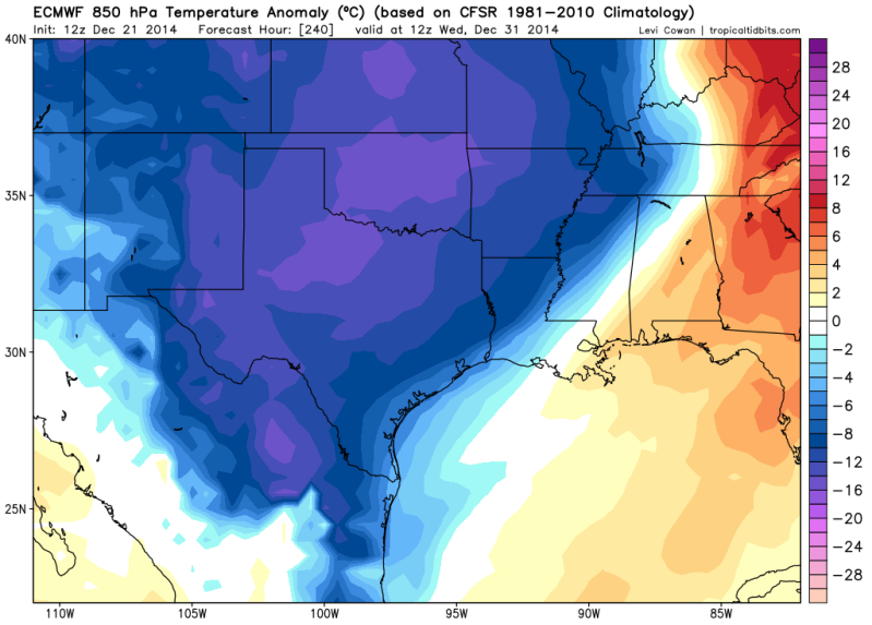
Very nice setup at the 500mb level for cold air to make its way down south! 
12zECMWF Operational 500mb Anomalies for December 31.

12zECMWF Operational 850 Temperature Anomalies for December 31.
12zECMWF Operational 500mb Anomalies for December 31.

12zECMWF Operational 850 Temperature Anomalies for December 31.

0 likes
The following post is NOT an official forecast and should not be used as such. It is just the opinion of the poster and may or may not be backed by sound meteorological data. It is NOT endorsed by any professional institution including storm2k.org For Official Information please refer to the NHC and NWS products.

Re: Texas Winter 2014-2015
ronyan wrote:The 12z GFS has a 1054mb high in Montana @ 216 hrs and actually builds the high up to 1058mb by the time it gets to the Colorado/Wyoming border. Those forecast temps are down also, though not as extreme as depicted before. Shows a high of 35F on New Year's day for IAH, with lows 27-28.
That type of high pressure is on par with 1962, 1983, and 1989.
0 likes
Re: Texas Winter 2014-2015
Ptarmigan wrote:ronyan wrote:The 12z GFS has a 1054mb high in Montana @ 216 hrs and actually builds the high up to 1058mb by the time it gets to the Colorado/Wyoming border. Those forecast temps are down also, though not as extreme as depicted before. Shows a high of 35F on New Year's day for IAH, with lows 27-28.
That type of high pressure is on par with 1962, 1983, and 1989.
It may come down how much cold air is available in our source region (Canada).
Current temps there not overly cold but that will change if a cross-polar flow is established.

Last edited by ronyan on Sun Dec 21, 2014 4:11 pm, edited 1 time in total.
0 likes
-
aggiecutter
- Category 5

- Posts: 1755
- Joined: Thu Oct 14, 2004 9:22 pm
- Location: Texarkana
Re: Texas Winter 2014-2015
ronyan wrote:Ptarmigan wrote:ronyan wrote:The 12z GFS has a 1054mb high in Montana @ 216 hrs and actually builds the high up to 1058mb by the time it gets to the Colorado/Wyoming border. Those forecast temps are down also, though not as extreme as depicted before. Shows a high of 35F on New Year's day for IAH, with lows 27-28.
That type of high pressure is on par with 1962, 1983, and 1989.
It may come down how much cold air is available in our source region (Canada).
Current temps there not overly cold but that will change if a cross-polar flow is established.

The 500mb flow is not 62-83, or 89. It is much more conducive to a January-February 78 type of pattern.
0 likes
Re: Texas Winter 2014-2015
The CPC analogs for 8-14 days have late dec 1977, but 1983 is also in the list.
0 likes
Who is online
Users browsing this forum: No registered users and 32 guests