Texas Winter 2011-2012...
Moderator: S2k Moderators
Forum rules
 The posts in this forum are NOT official forecast and should not be used as such. They are just the opinion of the poster and may or may not be backed by sound meteorological data. They are NOT endorsed by any professional institution or STORM2K.

The posts in this forum are NOT official forecast and should not be used as such. They are just the opinion of the poster and may or may not be backed by sound meteorological data. They are NOT endorsed by any professional institution or STORM2K.

Re:
SaskatchewanScreamer wrote:Please what does it show for Southern Alberta/ Saskatchewan the 23rd 24th and 25th? I've got children that will be driving 6 to 12 hours from Alberta home to Saskatchewan those days.
It looks dry and cold. Of course I have no experience/knowledge or enough data with Canada so this is the best thing I can do
http://www.weatheroffice.gc.ca/canada_e.html
0 likes
The above post and any post by Ntxw is NOT an official forecast and should not be used as such. It is just the opinion of the poster and may or may not be backed by sound meteorological data. It is NOT endorsed by any professional institution including Storm2k. For official information, please refer to NWS products.
Help support Storm2K!
-
weatherdude1108
- Category 5

- Posts: 4228
- Joined: Tue Dec 13, 2011 1:04 pm
- Location: Northwest Austin/Cedar Park, TX
The earlier discussion for Central Texas showed a cool damp Christmas weekend.
PREV DISCUSSION... /ISSUED 342 PM CST SUN DEC 18 2011/
DISCUSSION...
MODELS ARE TRENDING TOWARD THE CHRISTMAS WEEKEND AS
BEING CLOUDY...CHILLY AND DAMP. ANOTHER CANADIAN COLD FRONT MOVES
ACROSS SOUTH CENTRAL TEXAS BY FRIDAY. THERE ARE DIFFERENCES ON
TIMING AND INTENSITY OF THE UPPER LEVEL SHORTWAVE TROUGHS AND
POTENTIAL SURFACE LOW ALONG THE TEXAS COAST. FOR NOW...WILL GO
WITH SLIGHT CHANCES OF RAIN. WELL BELOW AVERAGE TEMPERATURES CAN
BE EXPECTED DUE TO CANADIAN HIGH PRESSURE.
&&
Last edited by weatherdude1108 on Mon Dec 19, 2011 12:59 pm, edited 1 time in total.
0 likes
The preceding post is NOT an official forecast, and should not be used as such. It is only the opinion of the poster and may or may not be backed by sound meteorological data. It is NOT endorsed by any professional institution including storm2k.org. For Official Information please refer to the NHC and NWS products.
0z GFS starting to follow the Euro. Cold front coming in time for Christmas as a strong trough kicks in. Vigorous energy dives south/east from the NW and strengthens heading in NW Mexico. Then begins brewing a winter storm for the state. Very interesting...verbatim, snow breaks out from the rio grand valley to San antonio, north and northeast.
0 likes
The above post and any post by Ntxw is NOT an official forecast and should not be used as such. It is just the opinion of the poster and may or may not be backed by sound meteorological data. It is NOT endorsed by any professional institution including Storm2k. For official information, please refer to NWS products.
Help support Storm2K!
Help support Storm2K!
-
GRAYSONCO.WX
- Category 1

- Posts: 450
- Joined: Thu Jan 06, 2011 4:29 pm
- Location: Denison, Texas
Re:
Ntxw wrote:0z GFS starting to follow the Euro. Cold front coming in time for Christmas as a strong trough kicks in. Vigorous energy dives south/east from the NW and strengthens heading in NW Mexico. Then begins brewing a winter storm for the state. Very interesting...verbatim, snow breaks out from the rio grand valley to San antonio, north and northeast.
When would the storm impact us if it panned out?
0 likes
Re: Re:
GRAYSONCO.WX wrote:When would the storm impact us if it panned out?
Christmas day/evening into the following day + or -. It would be a very interesting pattern set up especially for the southern half of the state if this panned out as is. Coastal troughs!
Lets see what the cmc and ecmwf says.
0 likes
The above post and any post by Ntxw is NOT an official forecast and should not be used as such. It is just the opinion of the poster and may or may not be backed by sound meteorological data. It is NOT endorsed by any professional institution including Storm2k. For official information, please refer to NWS products.
Help support Storm2K!
Help support Storm2K!
-
Rgv20

- S2K Supporter

- Posts: 2466
- Age: 39
- Joined: Wed Jan 05, 2011 5:42 pm
- Location: Edinburg/McAllen Tx
This are some pretty impressive 850mb temperature departures from tonights 0zGFS Ensembles  Looking more and more likely that the holiday weekend and early next week is going to be on the cool side
0zGFS Ensembles Mean 850mb Temperatures Anomalies for Monday Morning.
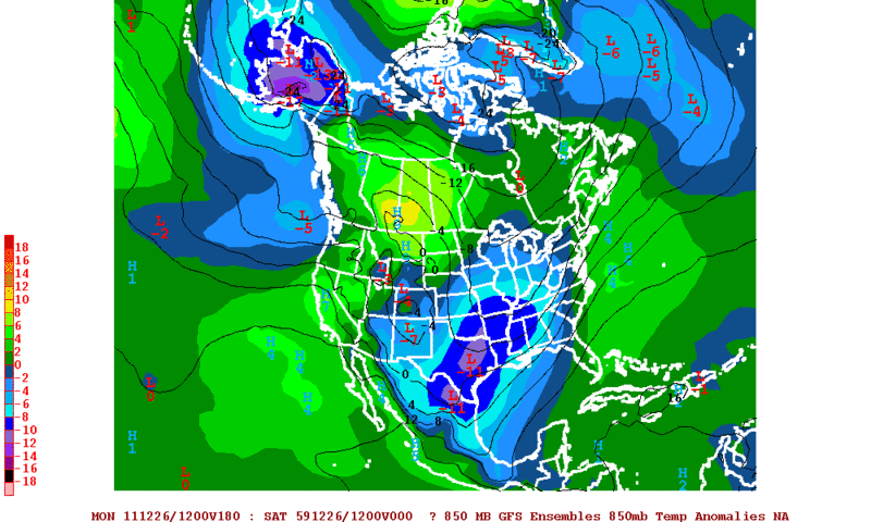
Looking more and more likely that the holiday weekend and early next week is going to be on the cool side 0zGFS Ensembles Mean 850mb Temperatures Anomalies for Monday Morning.
0 likes
The following post is NOT an official forecast and should not be used as such. It is just the opinion of the poster and may or may not be backed by sound meteorological data. It is NOT endorsed by any professional institution including storm2k.org For Official Information please refer to the NHC and NWS products.
Re: Texas Winter 2011-2012...
Canadian has the general same idea of cold, then a winter storm for Texas (Christmas-ish). Will be interesting to follow in the days ahead...gotta love those full latitude troughs.
0 likes
The above post and any post by Ntxw is NOT an official forecast and should not be used as such. It is just the opinion of the poster and may or may not be backed by sound meteorological data. It is NOT endorsed by any professional institution including Storm2k. For official information, please refer to NWS products.
Help support Storm2K!
Help support Storm2K!
-
aggiecutter
- Category 5
- Posts: 1755
- Joined: Thu Oct 14, 2004 9:22 pm
- Location: Texarkana
Re: Texas Winter 2011-2012...
Is that Portastorm or Bing Crosby I hear in the background. Could this possibly happen:
http://www.twisterdata.com/index.php?pr ... hive=false
http://www.twisterdata.com/index.php?pr ... hive=false
0 likes
Re: Texas Winter 2011-2012...
Wow what an amazing run! That would be a good few inches right on Christmas. Just this weekend my local met said Christmas is going to be on the cool side with no rain. 
0 likes

Re: Texas Winter 2011-2012...
0z Euro has light snow Christmas Eve/Christmas for Central, North Texas and Oklahoma as it phases the jets.
All in all tonight shows potential for a Christmas miracle somewhere in Texas, pattern wise. How much cold, do the jets phase, and where energy travels will all need some answers in the days ahead!
All in all tonight shows potential for a Christmas miracle somewhere in Texas, pattern wise. How much cold, do the jets phase, and where energy travels will all need some answers in the days ahead!
0 likes
The above post and any post by Ntxw is NOT an official forecast and should not be used as such. It is just the opinion of the poster and may or may not be backed by sound meteorological data. It is NOT endorsed by any professional institution including Storm2k. For official information, please refer to NWS products.
Help support Storm2K!
Help support Storm2K!
-
weatherdude1108
- Category 5
- Posts: 4228
- Joined: Tue Dec 13, 2011 1:04 pm
- Location: Northwest Austin/Cedar Park, TX
"I'm dreaming of a white Christmas..."
(?)
.PREV DISCUSSION... /ISSUED 415 AM CST MON DEC 19 2011/
THE CHRISTMAS WEEKEND LOOKS RATHER COOL DURING THE DAY AND COLD AT
NIGHT. AM LEANING MORE TOWARD THE DRIER ECMWF FOR SUNDAY WHEN THE
GFS BRINGS A MOISTURE LADEN TROUGH TX OVER THE TOP OF A COLD
SURFACE AIRMASS...THAT COULD POTENTIALLY GENERATE SOME WINTER
PRECIPITATION. DID INCLUDE SOME LOW RAIN CHANCES ACROSS THE SRN
CWA FOR SUNDAY...BUT OTHERWISE WILL WAIT FOR BETTER RUN TO RUN
CONSISTENCY BEFORE ADDING ANY WINTER WEATHER.
&&
Last edited by weatherdude1108 on Mon Dec 19, 2011 1:01 pm, edited 1 time in total.
0 likes
The preceding post is NOT an official forecast, and should not be used as such. It is only the opinion of the poster and may or may not be backed by sound meteorological data. It is NOT endorsed by any professional institution including storm2k.org. For Official Information please refer to the NHC and NWS products.

Re: Texas Winter 2011-2012...
From Shreveport NWS today... (just the last paragraph)
THE CHRISTMAS FORECAST IS STILL SOMEWHAT UNCLEAR WITH SOME MORE
LIGHT RAIN LOOKING SOMEWHAT LIKELY. ALTHOUGH TIMING AS TO WHEN IS
STILL NOT CONCRETE. AND TO MAKE IT INTERESTING...MODEL TEMPS ARE
ALL OVER THE PLACE AND WILL BEAR WATCHING. THE PATTERN WILL LIKELY
TREND COLDER OVER THE NEXT WEEK AS THE DOOR IS WIDE OPEN FOR FRESH
CANADIAN AIR. GFS AND EURO BRINGING IN A NICE COLD HIGH. THIS PLUS
THE CHANCE FOR MORE PRECIP AROUND THAT SPECIAL TIME WOULD BE
NEAT. AFTER ALL...IT IS ABOUT TO BE OFFICIALLY WINTER. /24/
0 likes
-
Portastorm

- Storm2k Moderator

- Posts: 9954
- Age: 63
- Joined: Fri Jul 11, 2003 9:16 am
- Location: Round Rock, TX
- Contact:
Re: Texas Winter 2011-2012...
A suggestion from Your Friendly Neighborhood Moderator ... when we are posting forecast discussions (and I've seen this several times of the last few days) from the NWS ... please just post the relevant portions. No need to post the entire thing (unless the entire thing is relevant). Or, you can post the entire thing but highlight in color text the relevant portion. It is also helpful if you include some text to provide WHY you are posting the forecast discussion.
Thank you ... and now back to the Panhandle Blizzard and the possible Christmas weekend winter weather event.
P.S. Nice job Kelarie ... that is how it is done!
Thank you ... and now back to the Panhandle Blizzard and the possible Christmas weekend winter weather event.
P.S. Nice job Kelarie ... that is how it is done!
0 likes
Any forecasts under my name are to be taken with a grain of salt. Get your best forecasts from the National Weather Service and National Hurricane Center.
-
wxman57

- Moderator-Pro Met

- Posts: 23170
- Age: 68
- Joined: Sat Jun 21, 2003 8:06 pm
- Location: Houston, TX (southwest)
Re: Texas Winter 2011-2012...
iorange55 wrote:The models must be sipping on a little too much eggnog.
I think that might be it. 00Z GFS was way out on its own solution-wise. Euro and Canadian don't agree, and neither does the 06Z GFS.
0 likes


Re: Texas Winter 2011-2012...
Always got to be scrooge lol.. no nice bike riding weather for you hehe.
0 likes
-
weatherdude1108
- Category 5
- Posts: 4228
- Joined: Tue Dec 13, 2011 1:04 pm
- Location: Northwest Austin/Cedar Park, TX
"Amarillo by Morning"
Or blizzard.
Looks like a wild couple days up there. Here is just one exerpt from the Amarillo NWS office (one paragraph)
A BLIZZARD WARNING REMAINS IN EFFECT UNTIL NOON CST TUESDAY.
* EVENT...HEAVY SNOW AND STRONG NORTH WINDS WILL IMPACT THE
OKLAHOMA PANHANDLE...AND NORTHERN AND WESTERN TEXAS
PANHANDLE...THIS MORNING INTO TUESDAY MORNING. STORM TOTAL
SNOWFALL ACCUMULATIONS OF 6 TO 16 INCHES ARE LIKELY. THE
HIGHEST TOTALS...IN THE 12 TO 16 INCH RANGE...CAN BE EXPECTED
ACROSS THE OKLAHOMA PANHANDLE AND NORTHWEST TEXAS PANHANDLE.
NORTH WINDS WILL INCREASE TO 25 TO 35 MPH WITH GUSTS UP TO 50
MPH BEHIND THE COLD FRONT TODAY...PRODUCING BLOWING AND
DRIFTING SNOW AND PERIODS OF WHITEOUT CONDITIONS.
0 likes
The preceding post is NOT an official forecast, and should not be used as such. It is only the opinion of the poster and may or may not be backed by sound meteorological data. It is NOT endorsed by any professional institution including storm2k.org. For Official Information please refer to the NHC and NWS products.
-
HockeyTx82
- S2K Supporter
- Posts: 2774
- Joined: Tue Oct 27, 2009 11:17 am
- Location: Ponder, TX
Re: Texas Winter 2011-2012...
Is there an outside chance that this storm today on the backend might have a little suprise for us here in NTX? Just seems like there is alot of energy out there. I guess it depends on the storm path. Just wishing........
0 likes
Don't hold me accountable for anything I post on this forum. Leave the real forecasting up to the professionals.
Location: Ponder, TX (all observation posts are this location unless otherwise noted)
Location: Ponder, TX (all observation posts are this location unless otherwise noted)
-
HockeyTx82
- S2K Supporter
- Posts: 2774
- Joined: Tue Oct 27, 2009 11:17 am
- Location: Ponder, TX
Re: Texas Winter 2011-2012...
Good writeup about the severe weather potential this afternoon around these parts. Not to many people talking about it on this board (guess because it's a Winter Weather forum?), what are your thoughts on the severe weather later on today?
http://forecast.weather.gov/product.php ... glossary=1
http://forecast.weather.gov/product.php ... glossary=1
0 likes
Don't hold me accountable for anything I post on this forum. Leave the real forecasting up to the professionals.
Location: Ponder, TX (all observation posts are this location unless otherwise noted)
Location: Ponder, TX (all observation posts are this location unless otherwise noted)
Who is online
Users browsing this forum: No registered users and 62 guests