LOL, 57 with the Lucy impersonation.
I'm hoping for no snow and/ice as we make our way down to Nawlins for Christmas. And crossing my fingers for Monday to be sunny and cool. Got 2 tix to the Monday Night game. Can't wait.
Texas Winter 2011-2012...
Moderator: S2k Moderators
Forum rules
 The posts in this forum are NOT official forecast and should not be used as such. They are just the opinion of the poster and may or may not be backed by sound meteorological data. They are NOT endorsed by any professional institution or STORM2K.

The posts in this forum are NOT official forecast and should not be used as such. They are just the opinion of the poster and may or may not be backed by sound meteorological data. They are NOT endorsed by any professional institution or STORM2K.


Re: Texas Winter 2011-2012...
Ouch for Portastorm that must've hurt  .
.
Latest NAM continues to develop strong vorticity through the four corners region as a positive trough which should allow cold air to dive south ahead of the system. Looks like where this thing 'rounds' about the base of the trough and goes neutral/negative is the prime position for wintry weather Christmas eve. Again caution this is the NAM beyond 48 hours.
Latest NAM continues to develop strong vorticity through the four corners region as a positive trough which should allow cold air to dive south ahead of the system. Looks like where this thing 'rounds' about the base of the trough and goes neutral/negative is the prime position for wintry weather Christmas eve. Again caution this is the NAM beyond 48 hours.
0 likes
The above post and any post by Ntxw is NOT an official forecast and should not be used as such. It is just the opinion of the poster and may or may not be backed by sound meteorological data. It is NOT endorsed by any professional institution including Storm2k. For official information, please refer to NWS products.
Help support Storm2K!


Re: Texas Winter 2011-2012...
Ntxw wrote:Ouch for Portastorm that must've hurt
Latest NAM continues to develop strong vorticity through the four corners region as a positive trough which should allow cold air to dive south ahead of the system. Looks like where this thing 'rounds' about the base of the trough and goes neutral/negative is the prime position for wintry weather Christmas eve. Again caution this is the NAM beyond 48 hours.
The NAM has been trending more on our side today. If the GFS starts to trend tonight, then I will start getting my hopes up.
0 likes

Re: Texas Winter 2011-2012...
THE NAM/ECMWF/CANADIAN KEEP THE UPSTREAM TROUGH IN THE NORTHERN
BRANCH...MOVING IT EAST ACROSS CANADA. THIS WOULD ENABLE OUR
SOUTHERN TROUGH NEAR NORTH TEXAS TO REMAIN THE DOMINANT TROUGH
BRINGING MUCH STRONGER LIFT AND COLDER TEMPERATURES ALOFT TO THE
CWA BEGINNING FRIDAY AND PERHAPS LASTING UNTIL SATURDAY. THE ECMWF
DID A COMPLETE 180 DEGREE TURN FROM ITS 00Z SOLUTION AND HANGS THE
TROUGH BACK ABOUT 12 HOURS...AND THEN TRACKS THE LOW OVER THE
CWA...PUTTING NORTH TEXAS IN A FAVORABLE SETUP FOR SNOW ACROSS
MUCH OF THE AREA ON SATURDAY. THE NAM IS A LITTLE WEAKER WITH THE
TROUGH...BUT WOULD STILL BE A DECENT SETUP FOR LIGHT SNOW ACROSS
THE NORTHERN HALF OF THE FORECAST AREA FRIDAY AND FRIDAY NIGHT.
THE CANADIAN HANGS THE TROUGH TO THE WEST LONGER THAN THE ECMWF
AND MOST OF OUR MOISTURE WOULD BE SCOURED OUT BEHIND THE COLD
FRONT BY THEN AND WE WOULDNT SEE MUCH PRECIP.
AS YOU CAN TELL FROM EVERYTHING DESCRIBED ABOVE...THERE ARE ALOT
OF VARIABLES THAT HAVE TO BE DETERMINED BEFORE WE CAN HAVE
CONFIDENCE IN A SNOW FORECAST FOR FRIDAY/SATURDAY. IF IT WERE TO
SNOW...LOW MOISTURE CONTENT WOULD ONLY SUPPORT LIGHT SNOWFALL
ACCUMULATIONS...BELOW WARNING CRITERIA...UNLESS MESOSCALE BANDING
WERE TO OCCUR. GIVEN THAT THIS IS THE FIRST MODEL RUN TO REALLY
JUMP ON BOARD...FELT IT WAS BEST TO ONLY INTRODUCE 20 POPS INTO
THE FORECAST ACROSS THE NORTHWESTERN AREAS FRIDAY AND FRIDAY
NIGHT WHERE PRECIPITATION IS MOST LIKELY TO FALL NO MATTER WHAT
SOLUTION OCCURS. TEMPERATURES FRIDAY IN THIS AREA WILL BE IN THE
MIDDLE 30S AND WENT WITH A RAIN OR SNOW WEATHER TYPE. FRIDAY
NIGHT...LOWS ARE EXPECTED TO BE WELL BELOW FREEZING AND WENT WITH
A SLIGHT CHANCE OF SNOW. AGAIN...THIS IS AN EVER- EVOLVING
FORECAST AND THINGS CAN CERTAINLY CHANGE ONE WAY OR THE OTHER.
Anyone else read this from the Fort Worth NWS?
0 likes

Re: Texas Winter 2011-2012...
Check this out!
AREA FORECAST DISCUSSION
NATIONAL WEATHER SERVICE SHREVEPORT LA
307 PM CST TUE DEC 20 2011
.DISCUSSION.
BOTH THE EURO AND GFS
CONTINUE THE SUPPLY OF UPPER DISTURBANCES...BUT THEY WIDELY DIFFER
IN HOW THEY PROGRESS THESE DISTURBANCES. FOR THE CHRISTMAS WEEKEND
SYSTEM...BOTH MODELS EJECT ANOTHER UPPER TROF INTO W TX BY LATE
FRI...BUT ONLY THE EURO STRENGTHENS IT AND MOVES IT OUT INTO THE
SRN PLAINS/N TX. IF THE CURRENT EURO VERIFIES...IT COULD MEAN A
WHITE CHRISTMAS FOR A LARGE PORTION OF TX.
0 likes


Re: Texas Winter 2011-2012...
Portastorm wrote:Hey ... I'm calling a foul on that one! I read the first sentence of your post and ran screaming down the hallway like a little girl.
And to think I voted for you for the Best Cycling Meteorologist of the Year award.
Don't feel bad port,i was hoodwinked too.
0 likes
Re: Texas Winter 2011-2012...
Turtle wrote:Check this out!
AREA FORECAST DISCUSSION
NATIONAL WEATHER SERVICE SHREVEPORT LA
307 PM CST TUE DEC 20 2011
.DISCUSSION.BOTH THE EURO AND GFS
CONTINUE THE SUPPLY OF UPPER DISTURBANCES...BUT THEY WIDELY DIFFER
IN HOW THEY PROGRESS THESE DISTURBANCES. FOR THE CHRISTMAS WEEKEND
SYSTEM...BOTH MODELS EJECT ANOTHER UPPER TROF INTO W TX BY LATE
FRI...BUT ONLY THE EURO STRENGTHENS IT AND MOVES IT OUT INTO THE
SRN PLAINS/N TX. IF THE CURRENT EURO VERIFIES...IT COULD MEAN A
WHITE CHRISTMAS FOR A LARGE PORTION OF TX.
That is quite a tease by both them and the Euro!
0 likes
-
somethingfunny

- ChatStaff

- Posts: 3926
- Age: 37
- Joined: Thu May 31, 2007 10:30 pm
- Location: McKinney, Texas
Dear Santa,
I have been such a good boy this year and so has every boy and girl in the Storm2k Texas Winter 2011-2012 thread. We hope you read this before tonight's 00z ECMWF run.
I have been such a good boy this year and so has every boy and girl in the Storm2k Texas Winter 2011-2012 thread. We hope you read this before tonight's 00z ECMWF run.
0 likes
I am not a meteorologist, and any posts made by me are not official forecasts or to be interpreted as being intelligent. These posts are just my opinions and are probably silly opinions.
Something to think about in the long run. Around new years will be in the fall of a 'mini' +PNA spike. It is usually when the PNA begins to fall from a rise that you will find a storm tracking across the southern plains (it takes a bit of time for weather to translate downstream). At the same time Alaska is going back into the deep freeze after Christmas, this resembles the pattern we had late Nov early Dec except after tonight we will be in true winter and the sun angle is at it's lowest point. Just something to think about heading into the new year.

Uploaded with ImageShack.us

Uploaded with ImageShack.us
Edit: I don't know how accurate or reliable the JMA is but sure is eye candy

Uploaded with ImageShack.us

Uploaded with ImageShack.us

Uploaded with ImageShack.us
Edit: I don't know how accurate or reliable the JMA is but sure is eye candy

Uploaded with ImageShack.us
0 likes
The above post and any post by Ntxw is NOT an official forecast and should not be used as such. It is just the opinion of the poster and may or may not be backed by sound meteorological data. It is NOT endorsed by any professional institution including Storm2k. For official information, please refer to NWS products.
Help support Storm2K!
Help support Storm2K!
Re:
Ntxw wrote:
Edit: I don't know how accurate or reliable the JMA is but sure is eye candy
Uploaded with ImageShack.us
I know Frank Strait likes to show it sometimes, so it probably has at least a little bit of credibility.
I hope.
0 likes
-
orangeblood
- S2K Supporter

- Posts: 3895
- Joined: Tue Dec 15, 2009 6:14 pm
- Location: Fort Worth, TX
Re: Texas Winter 2011-2012...
To me, it still appears the models are underestimating the upper level energy or if they aren't are having trouble piecing it all together. The energy coming out of the northwest flow, behind the main energy coming together later this week, is something to watch as this could deepen this storm even further.
The following post is NOT an official forecast and should not be used as such. It is just the opinion of the poster and may or may not be backed by sound meteorological data. It is NOT endorsed by any professional institution including storm2k.org. For official information, please refer to NWS products.
The following post is NOT an official forecast and should not be used as such. It is just the opinion of the poster and may or may not be backed by sound meteorological data. It is NOT endorsed by any professional institution including storm2k.org. For official information, please refer to NWS products.
0 likes
-
Rgv20

- S2K Supporter
- Posts: 2466
- Age: 39
- Joined: Wed Jan 05, 2011 5:42 pm
- Location: Edinburg/McAllen Tx
Re:
Ntxw wrote:Something to think about in the long run. Around new years will be in the fall of a 'mini' +PNA spike. It is usually when the PNA begins to fall from a rise that you will find a storm tracking across the southern plains (it takes a bit of time for weather to translate downstream). At the same time Alaska is going back into the deep freeze after Christmas, this resembles the pattern we had late Nov early Dec except after tonight we will be in true winter and the sun angle is at it's lowest point. Just something to think about heading into the new year.
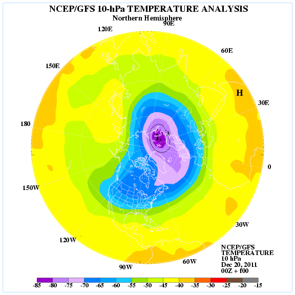
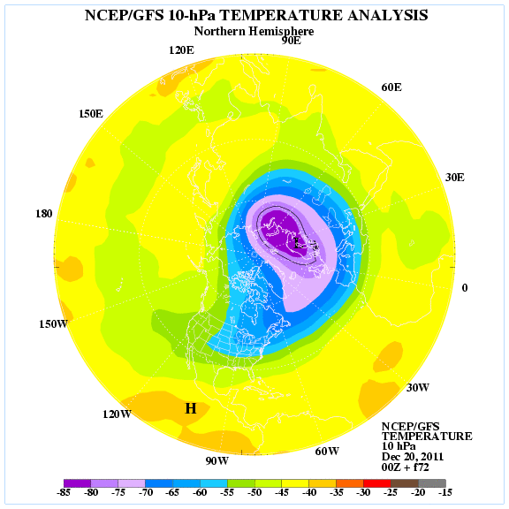
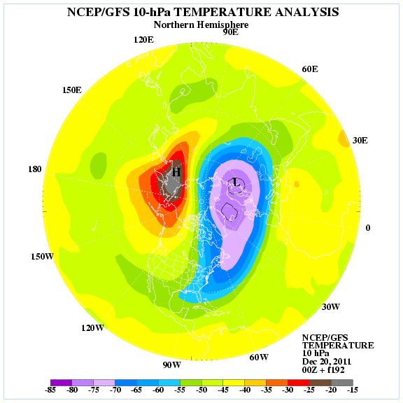
Something to take note off is the likelihood of the stratospheric warming event to occur in the next couple of days. The surface weather lags about 10 days give or take which would make early January a prime candidate for some cold air to come down. Notice how the colors get brighter (Meaning warmer temperatures) in Alaska/NW Canada as we go in time.
Initialize yesterday at 7pm
7pm December 22
7pm December 27
Now my attention goes back to the upcoming holiday weekend weather which needless to say is a difficult forecast for the state of Texas!
0 likes
The following post is NOT an official forecast and should not be used as such. It is just the opinion of the poster and may or may not be backed by sound meteorological data. It is NOT endorsed by any professional institution including storm2k.org For Official Information please refer to the NHC and NWS products.
-
gboudx

- S2K Supporter
- Posts: 4090
- Joined: Thu Sep 04, 2003 1:39 pm
- Location: Rockwall, Tx but from Harvey, La
Interesting discussion from Larry regarding the potential snow/sleet for NTX on Sunday. Also he talks about the weather next week and what cold signals to look for. Ntx is on the,right track in his post.
http://www.examiner.com/weather-in-hous ... ts_article
http://www.examiner.com/weather-in-hous ... ts_article
0 likes
-
orangeblood
- S2K Supporter
- Posts: 3895
- Joined: Tue Dec 15, 2009 6:14 pm
- Location: Fort Worth, TX
Re: Texas Winter 2011-2012...
Rgv20, that arctic air might take longer to get down into this part of the US as it appears it will stake claim on Alaska into the PAC northwest to start of the new year - you normally will need that warm anomaly to make it into Central Canada before we can get too excited around here. I would expect the true arctic air to make it down here around the middle to latter part of next month. It's just something I've noticed with these SSW events over the years!! But who knows every winter seems to have many unexpected outcomes to it.
0 likes
Latest GFS = DR NO! In fact it tries to warm things up for Christmas. Who saw it coming? 
One difference though from the 12z GFS is that at 500mb the vorticity is more consolidated and less sheared.
One difference though from the 12z GFS is that at 500mb the vorticity is more consolidated and less sheared.
Last edited by Ntxw on Tue Dec 20, 2011 11:28 pm, edited 1 time in total.
0 likes
The above post and any post by Ntxw is NOT an official forecast and should not be used as such. It is just the opinion of the poster and may or may not be backed by sound meteorological data. It is NOT endorsed by any professional institution including Storm2k. For official information, please refer to NWS products.
Help support Storm2K!
Help support Storm2K!
-
orangeblood
- S2K Supporter
- Posts: 3895
- Joined: Tue Dec 15, 2009 6:14 pm
- Location: Fort Worth, TX
Re:
Ntxw wrote:Latest GFS = DR NO! In fact it tries to warm things up for Christmas. Who saw it coming?
Seemed like a trend in the right direction to me...it digs the energy further south and is much less progressive compared to the last few runs. I wouldn't get too worried with the surface features right now...it's all about the upper level energy orienting itself in a favorable manor and everything else should follow suit. Also, don't you remember the GFS bias towards scouring cold air out too soon!!
0 likes
Re: Re:
orangeblood wrote:Seemed like a trend in the right direction to me...it digs the energy further south and is much less progressive compared to the last few runs. I wouldn't get too worried with the surface features right now...it's all about the upper level energy orienting itself in a favorable manor and everything else should follow suit. Also, don't you remember the GFS bias towards scouring cold air out too soon!!
Yeah I was just comparing 12z vs 0z at the 500mb level. It's not as sheared out and coming out in bits but as one piece. I also notice it try but not quite get there phasing some energy with the incoming Pac NW stuff.
To add there are a number of SREF members that are quite aggressive with precip, but don't fully go out that far yet.
0 likes
The above post and any post by Ntxw is NOT an official forecast and should not be used as such. It is just the opinion of the poster and may or may not be backed by sound meteorological data. It is NOT endorsed by any professional institution including Storm2k. For official information, please refer to NWS products.
Help support Storm2K!
Help support Storm2K!
-
orangeblood
- S2K Supporter
- Posts: 3895
- Joined: Tue Dec 15, 2009 6:14 pm
- Location: Fort Worth, TX
Re: Re:
Ntxw wrote:orangeblood wrote:Seemed like a trend in the right direction to me...it digs the energy further south and is much less progressive compared to the last few runs. I wouldn't get too worried with the surface features right now...it's all about the upper level energy orienting itself in a favorable manor and everything else should follow suit. Also, don't you remember the GFS bias towards scouring cold air out too soon!!
Yeah I was just comparing 12z vs 0z at the 500mb level. It's not as sheared out and coming out in bits but as one piece. I also notice it try but not quite get there phasing some energy with the incoming Pac NW stuff.
To add there are a number of SREF members that are quite aggressive with precip, but don't fully go out that far yet.
It's starting to appear that the big key in all of this is the following system coming out of the Pac nw...the GFS and NAM think it's much stronger than what the Euro is showing thus shearing the trough, never letting it dig further south and becoming neutral/negatively tilted. GFS looks way under done on this system in the southern branch!!!
The following post is NOT an official forecast and should not be used as such. It is just the opinion of the poster and may or may not be backed by sound meteorological data. It is NOT endorsed by any professional institution including storm2k.org. For official information, please refer to NWS products.
0 likes
Who is online
Users browsing this forum: Stratton23, Teban54, wxman22 and 55 guests