Winter 2010-11 for the Southern Plains
Moderator: S2k Moderators
Forum rules
 The posts in this forum are NOT official forecast and should not be used as such. They are just the opinion of the poster and may or may not be backed by sound meteorological data. They are NOT endorsed by any professional institution or STORM2K.

The posts in this forum are NOT official forecast and should not be used as such. They are just the opinion of the poster and may or may not be backed by sound meteorological data. They are NOT endorsed by any professional institution or STORM2K.


Re:
snowcane180 wrote:what do the temps look like for southern georgia
From my best guess through the EC (colder of the models) parts of central and southern GA could expect to see frosts and freezes late next week. Perhaps 50-60s for highs? 850 temps actually has the 0c therm line down to the gulf coast, so it's not inconceivable it could well be in the 30s even down there should that verify.
0 likes
The above post and any post by Ntxw is NOT an official forecast and should not be used as such. It is just the opinion of the poster and may or may not be backed by sound meteorological data. It is NOT endorsed by any professional institution including Storm2k. For official information, please refer to NWS products.
Help support Storm2K!
-
Extremeweatherguy

- Category 5

- Posts: 11095
- Joined: Mon Oct 10, 2005 8:13 pm
- Location: Florida
12z ECMWF (Oct. 31st, 2010):
WED MORNING (850mb temperatures/SLP):
THURS MORNING (850mb temperatures/SLP):
FRI MORNING (850mb temperatures/SLP):
SAT MORNING (850mb temperatures/SLP):
12z GFS (Oct. 31st, 2010):
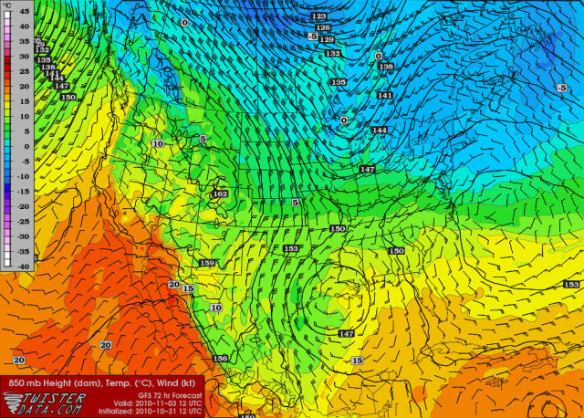
WED MORNING (850mb temperatures/wind/height):
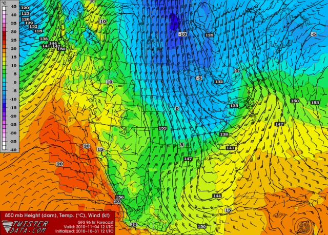
THURS MORNING (850mb temperatures/wind/height):
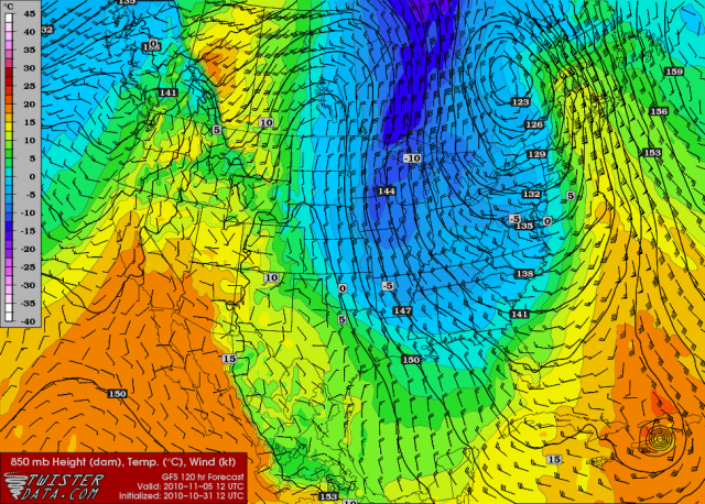
FRI MORNING (850mb temperatures/wind/height):
SAT MORNING (850mb temperatures/wind/height):
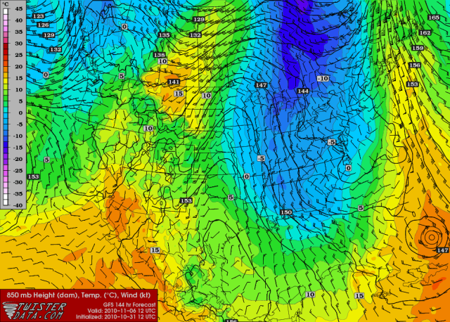
***Keep in mind that surface temperatures can differ from 850mb temperatures.***
WED MORNING (850mb temperatures/SLP):
THURS MORNING (850mb temperatures/SLP):
FRI MORNING (850mb temperatures/SLP):
SAT MORNING (850mb temperatures/SLP):
12z GFS (Oct. 31st, 2010):
WED MORNING (850mb temperatures/wind/height):
THURS MORNING (850mb temperatures/wind/height):
FRI MORNING (850mb temperatures/wind/height):
SAT MORNING (850mb temperatures/wind/height):
***Keep in mind that surface temperatures can differ from 850mb temperatures.***
0 likes
-
TwisterFanatic

- Category 5
- Posts: 1041
- Joined: Mon Jun 28, 2010 12:43 pm
- Location: Sallisaw, Oklahoma
So, its looks like to me. I could have quick shot of colder air.
0 likes
Personal Forecast Disclaimer:
The posts in this forum are NOT official forecast and should not be used as such. They are just the opinion of the poster and may or may not be backed by sound meteorological data. They are NOT endorsed by any professional institution or storm2k.org. For official information, please refer to the NHC and NWS products.
The posts in this forum are NOT official forecast and should not be used as such. They are just the opinion of the poster and may or may not be backed by sound meteorological data. They are NOT endorsed by any professional institution or storm2k.org. For official information, please refer to the NHC and NWS products.
-
snowcane180
-
Extremeweatherguy
- Category 5
- Posts: 11095
- Joined: Mon Oct 10, 2005 8:13 pm
- Location: Florida
Re: Winter 2010-11 for the Southern Plains
Tonight's 00z ECMWF and GFS are slightly warmer for us/further east with the mid and late week cold airmass. They still look seasonably chilly, and would likely still equate to our coldest temperatures of the season; but we only get a glancing taste of the airmass overall.
This seems to be a trend with the models lately though. The 00z runs all seem to be warmer/further east with the cold, while the 12z runs all tend to be colder/further west with the cold.
Will this pattern continue with the next set of 12z runs? I guess we'll find out later today..
This seems to be a trend with the models lately though. The 00z runs all seem to be warmer/further east with the cold, while the 12z runs all tend to be colder/further west with the cold.
Will this pattern continue with the next set of 12z runs? I guess we'll find out later today..
0 likes
-
TwisterFanatic
- Category 5
- Posts: 1041
- Joined: Mon Jun 28, 2010 12:43 pm
- Location: Sallisaw, Oklahoma
Re: Winter 2010-11 for the Southern Plains
Extremeweatherguy wrote:Tonight's 00z ECMWF and GFS are slightly warmer for us/further east with the mid and late week cold airmass. They still look seasonably chilly, and would likely still equate to our coldest temperatures of the season; but we only get a glancing taste of the airmass overall.
This seems to be a trend with the models lately though. The 00z runs all seem to be warmer/further east with the cold, while the 12z runs all tend to be colder/further west with the cold.
Will this pattern continue with the next set of 12z runs? I guess we'll find out later today..
The weather guys here in Eastern OK seem to think they colder solution will happen. They have lower 50's for highs and mid to upper 20's at night.
0 likes
Personal Forecast Disclaimer:
The posts in this forum are NOT official forecast and should not be used as such. They are just the opinion of the poster and may or may not be backed by sound meteorological data. They are NOT endorsed by any professional institution or storm2k.org. For official information, please refer to the NHC and NWS products.
The posts in this forum are NOT official forecast and should not be used as such. They are just the opinion of the poster and may or may not be backed by sound meteorological data. They are NOT endorsed by any professional institution or storm2k.org. For official information, please refer to the NHC and NWS products.
-
Extremeweatherguy
- Category 5
- Posts: 11095
- Joined: Mon Oct 10, 2005 8:13 pm
- Location: Florida
Re: Winter 2010-11 for the Southern Plains
The flip back to cold was not as great in today's 12z model runs. They are slightly cooler than last night's 00z, but overall it looks like the GFS and ECMWF may be starting converge on a similar scenario; with the brunt of the cold headed for the upper midwest, the mid mississippi valley and down into the southeast, with the southern plains just getting a taste of the western edge. The "taste" will still likely be enough to bring a freeze to a good chunk of Oklahoma by Friday morning though, with highs near or below 60F for a couple of days. Northeastern Oklahoma might even struggle to top 50F on Friday afternoon under sunny skies. All-in-all though, this is looking like just a "typical" early November cool down, with nothing unusual or particularly spectacular expected. Oklahoma City's early November record low of 11F (Nov. 3rd, 1991) will definitely not be in jeopardy this time around. (lol)
( Brief Update- well it now looks like we might not get those couple of days with highs near or below 60F. The latest NWS forecast update now has highs in the lower to middle 60s to end the week in OKC; removing the 50s from the forecast. The low temperatures still look chilly though, with a frost or freeze still being forecasted by the NWS for many.
It is worth noting though that the models do look slightly cooler with the highs, so may be the NWS will lower them again in the future.. )
Last edited by Extremeweatherguy on Tue Nov 02, 2010 11:02 am, edited 3 times in total.
0 likes
Re: Winter 2010-11 for the Southern Plains
Extremeweatherguy wrote:The flip back to cold was not as great in today's 12z model runs. They are slightly cooler than last night's 00z, but overall it looks like the GFS and ECMWF may be starting converge on a similar scenario; with the brunt of the cold headed for the upper midwest, the mid mississippi valley and down into the southeast, with the southern plains just getting a taste of the western edge. The "taste" will still likely be enough to bring a freeze to a good chunk of Oklahoma by Friday morning though, with highs near or below 60F for a couple of days. Northeastern Oklahoma might even struggle to top 50F on Friday afternoon under sunny skies. All-in-all though, this is looking like just a "typical" early November cool down, with nothing unusual or particularly spectacular expected. Oklahoma City's early November record low of 11F (Nov. 3rd, 1991) will definitely not be in jeopardy this time around. (lol)
I think this first set of weather patterns will say lots about this winter. Today was a nice warm day for the southern plains with about average nightly readings. A cold intrusion is set to come in with the brunt of it heading towards the eastern conus.
Midwest, Northeast will have the chilliest readings and the deep south a brief clip. A rogue storm will make things windy and damp for about a day in the southern plains and quickly rebound (though not linked but the unusual SJT may have something to do this winter).
0 likes
The above post and any post by Ntxw is NOT an official forecast and should not be used as such. It is just the opinion of the poster and may or may not be backed by sound meteorological data. It is NOT endorsed by any professional institution including Storm2k. For official information, please refer to NWS products.
Help support Storm2K!
Help support Storm2K!
-
somethingfunny

- ChatStaff

- Posts: 3926
- Age: 37
- Joined: Thu May 31, 2007 10:30 pm
- Location: McKinney, Texas
Re: Winter 2010-11 for the Southern Plains

Heck of a low pressure system moving across Texas today.
52°, north winds sustained at 26mph gusting to 32mph, 1.3" of rain so far and several hours more to come....
I love winter, but this part sucks.

0 likes
I am not a meteorologist, and any posts made by me are not official forecasts or to be interpreted as being intelligent. These posts are just my opinions and are probably silly opinions.
If this were a month or two later, would make for a nice wintry system from N, Central, to SE Texas with the backlash side of the intense low. Definitely the right set up for it. Imagine if all that rain was sneux 
0 likes
The above post and any post by Ntxw is NOT an official forecast and should not be used as such. It is just the opinion of the poster and may or may not be backed by sound meteorological data. It is NOT endorsed by any professional institution including Storm2k. For official information, please refer to NWS products.
Help support Storm2K!
Help support Storm2K!
-
CaptinCrunch

- S2K Supporter

- Posts: 8776
- Age: 58
- Joined: Mon Nov 03, 2003 4:33 pm
- Location: Kennedale, TX (Tarrant Co.)
Re: Winter 2010-11 for the Southern Plains
Still raining in Fort Worth this morning with a temp of 48. Will continue to be chilly thru Saturday with high's not getting above 70 till Sunday. Looks like mid 70's by mid next week before next cold front by the weekend.
0 likes


-
Extremeweatherguy
- Category 5
- Posts: 11095
- Joined: Mon Oct 10, 2005 8:13 pm
- Location: Florida
Re: Winter 2010-11 for the Southern Plains
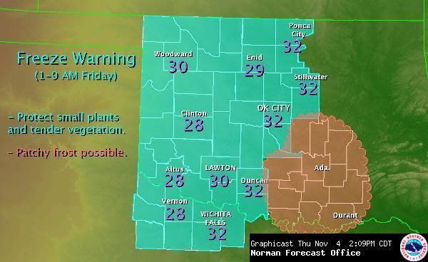
Expected Low Temperatures Tonight:
Actual Low Temperatures:
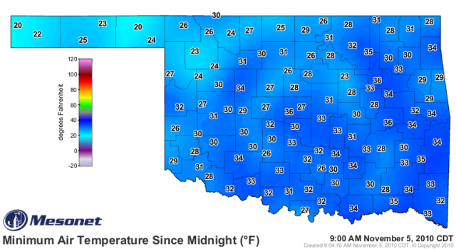
updated to include actual lows
Actual Low Temperatures:
updated to include actual lows
Last edited by Extremeweatherguy on Fri Nov 05, 2010 9:06 am, edited 1 time in total.
0 likes
-
Extremeweatherguy
- Category 5
- Posts: 11095
- Joined: Mon Oct 10, 2005 8:13 pm
- Location: Florida
So far the winds are staying up just enough to ease our temperature fall tonight. We did get down into the lower 40s for a while, but some mixing has brought the temperature back up into the mid 40s (for the OKC region) at midnight. If the wind can die down below 5-10mph at any point overnight though, then I expect the temperature to fall quickly. With dewpoints in the low-mid 20s, there is still plenty of room for cooling.
0 likes
-
Extremeweatherguy
- Category 5
- Posts: 11095
- Joined: Mon Oct 10, 2005 8:13 pm
- Location: Florida
We have another freeze warning tonight; and with lighter winds in place, I wouldn't be surprised to see the temperature slightly colder tomorrow morning than it was today (especially the eastern 2/3rds of Oklahoma and N. Texas).
Beyond tonight though, our eyes turn toward late next week and the weeks to follow (leading up to Thanksgiving). The models (GFS, ECMWF) have been quite consistent in showing a much colder and much stormier pattern setting up across the nation in this timeframe. There is some indication that by the middle of the month (6-16 days), we might even be dealing with a winter precipitation threats across northern parts of the region (TX panhandle, S KS, OK, perhaps N TX). Regardless of whether any of those threats actually pan out; the next few weeks will definitely be interesting to watch unfold..
Beyond tonight though, our eyes turn toward late next week and the weeks to follow (leading up to Thanksgiving). The models (GFS, ECMWF) have been quite consistent in showing a much colder and much stormier pattern setting up across the nation in this timeframe. There is some indication that by the middle of the month (6-16 days), we might even be dealing with a winter precipitation threats across northern parts of the region (TX panhandle, S KS, OK, perhaps N TX). Regardless of whether any of those threats actually pan out; the next few weeks will definitely be interesting to watch unfold..
0 likes
Run after run have hinted (particularly the GFS...which amazingly has done a decent job this year) at the pattern setup for winter. My bet is that snow will likely fall from the rockies to the Great lakes sometime next week setting up a chilly pattern in which maybe moving into the southern plains sector. I wouldn't be surprised if snow has fallen by Thanksgiving in the Tx and Ok panhandles if the models do verify with several cutoff storms.
0 likes
The above post and any post by Ntxw is NOT an official forecast and should not be used as such. It is just the opinion of the poster and may or may not be backed by sound meteorological data. It is NOT endorsed by any professional institution including Storm2k. For official information, please refer to NWS products.
Help support Storm2K!
Help support Storm2K!
Who is online
Users browsing this forum: Google Adsense [Bot] and 99 guests