
Southern Plains winter wx thread (2008-2009)
Moderator: S2k Moderators
Forum rules
 The posts in this forum are NOT official forecast and should not be used as such. They are just the opinion of the poster and may or may not be backed by sound meteorological data. They are NOT endorsed by any professional institution or STORM2K.

The posts in this forum are NOT official forecast and should not be used as such. They are just the opinion of the poster and may or may not be backed by sound meteorological data. They are NOT endorsed by any professional institution or STORM2K.
-
Extremeweatherguy

- Category 5

- Posts: 11095
- Joined: Mon Oct 10, 2005 8:13 pm
- Location: Florida
Re: Southern Plains winter wx thread
Numbers are busting here in Oklahoma too. Yesterday evening the forecast for OKC today was 81F. As you can see from the map below, that is definitely not going to happen...
0 likes
-
Extremeweatherguy
- Category 5
- Posts: 11095
- Joined: Mon Oct 10, 2005 8:13 pm
- Location: Florida
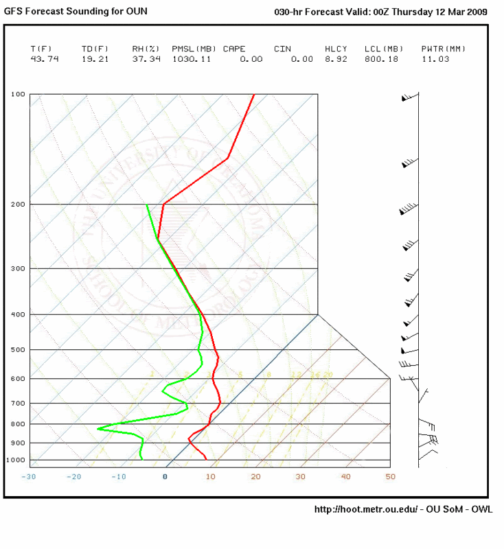
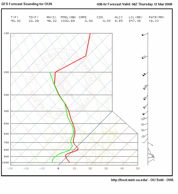
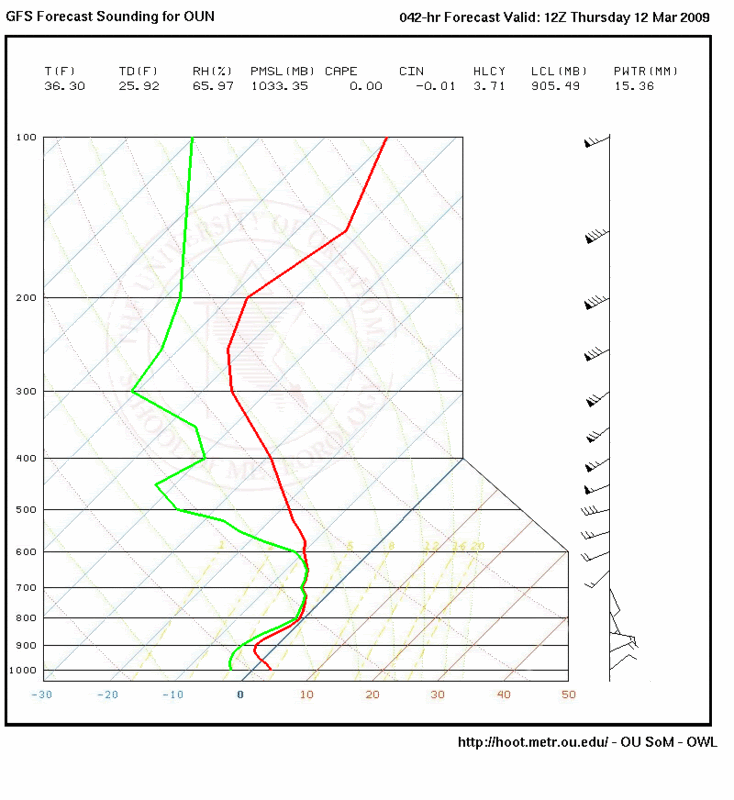
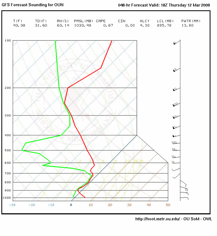
18z GFS forecasted skew-T's for OUN (Norman, OK):
00z Thursday: http://i43.photobucket.com/albums/e371/ ... 1236727746
06z Thursday: http://i43.photobucket.com/albums/e371/ ... 1236727729
12z Thursday: http://i43.photobucket.com/albums/e371/ ... 1236727481
18z Thursday: http://i43.photobucket.com/albums/e371/ ... 1236727760
Norman is slightly south of Oklahoma City, but the skew-T's should be fairly similar throughout the general region...
0 likes
-
Texas Snowman

- Storm2k Moderator

- Posts: 6197
- Joined: Fri Jan 25, 2008 11:29 am
- Location: Denison, Texas
Re: Southern Plains winter wx thread
At 8 p.m., it was humid and 71 degrees here in the Red River Valley with a south wind.
About 20 minutes ago, the front came through. Temps are now in 50s with a north wind of 26 mph, gusting to 35 mph.
Tx Snowman
About 20 minutes ago, the front came through. Temps are now in 50s with a north wind of 26 mph, gusting to 35 mph.
Tx Snowman
0 likes
-
Extremeweatherguy
- Category 5
- Posts: 11095
- Joined: Mon Oct 10, 2005 8:13 pm
- Location: Florida
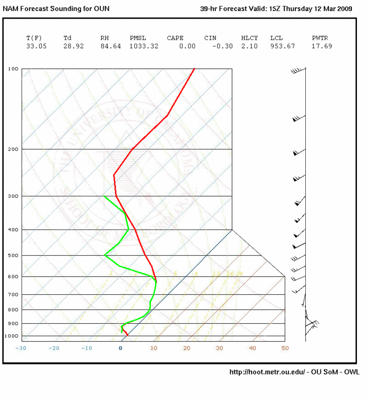
00z NAM forecasted skew-T for 15Z Thursday at OUN looks pretty interesting: http://i43.photobucket.com/albums/e371/ ... 1236739605
0 likes
-
Ed Mahmoud
Re:
Extremeweatherguy wrote:00z NAM forecasted skew-T for 15Z Thursday at OUN looks pretty interesting: http://i43.photobucket.com/albums/e371/ ... 1236739605
0Z NAM is a healthy 7º C too warm compared to the actual 0Z OKC ob, almost 2ºC too warm at Liberal, so maybe things are going to work out.
Of course, it was a degree too cool in Denver compared to the ob.
0 likes
-
Extremeweatherguy
- Category 5
- Posts: 11095
- Joined: Mon Oct 10, 2005 8:13 pm
- Location: Florida
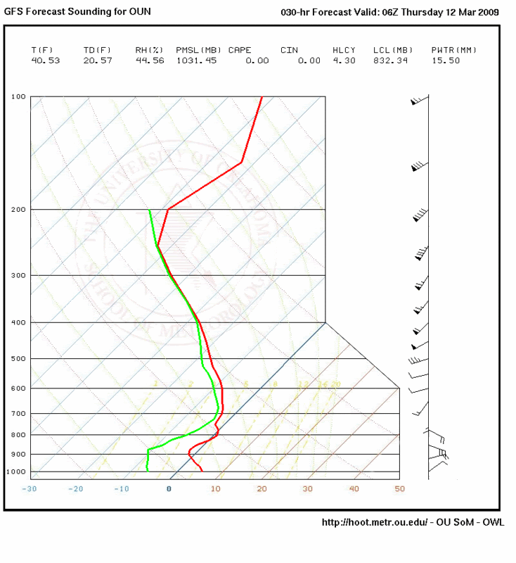
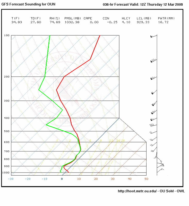
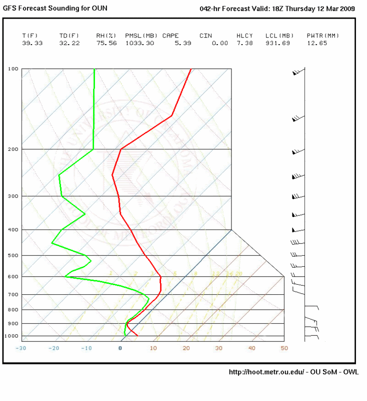
00z GFS run is also looking slightly more interesting tonight...
SURFACE
6z Thurs - http://www.nco.ncep.noaa.gov/pmb/nwprod ... n_030l.gif
12z Thurs - http://www.nco.ncep.noaa.gov/pmb/nwprod ... n_036l.gif
18z Thurs - http://www.nco.ncep.noaa.gov/pmb/nwprod ... n_042l.gif
850MB
6z Thurs - http://www.nco.ncep.noaa.gov/pmb/nwprod ... p_030l.gif
12z Thurs - http://www.nco.ncep.noaa.gov/pmb/nwprod ... p_036l.gif
18z Thurs - http://www.nco.ncep.noaa.gov/pmb/nwprod ... p_042l.gif
700MB
6z Thurs - http://www.nco.ncep.noaa.gov/pmb/nwprod ... 0_030l.gif
12z Thurs - http://www.nco.ncep.noaa.gov/pmb/nwprod ... 0_036l.gif
18z Thurs - http://www.nco.ncep.noaa.gov/pmb/nwprod ... 0_042l.gif
SKEW-T
6z Thurs - http://i43.photobucket.com/albums/e371/ ... 1236746818
12z Thurs - http://i43.photobucket.com/albums/e371/ ... 1236746806
18z Thurs - http://i43.photobucket.com/albums/e371/ ... 1236746790
0 likes
-
Extremeweatherguy
- Category 5
- Posts: 11095
- Joined: Mon Oct 10, 2005 8:13 pm
- Location: Florida
-
srainhoutx

- S2K Supporter

- Posts: 6919
- Age: 68
- Joined: Sun Jan 14, 2007 11:34 am
- Location: Haywood County, NC
- Contact:
Re: Southern Plains winter wx thread
EWG, I noticed that Lubbock and Midland/Odessa has added snow/ice in the forecast as well with a Winter Weather Advisory issued. Enjoy your late season "winter type" storm. 
0 likes
-
Portastorm

- Storm2k Moderator
- Posts: 9954
- Age: 63
- Joined: Fri Jul 11, 2003 9:16 am
- Location: Round Rock, TX
- Contact:
Re:
gboudx wrote:I'm just enjoying the cold rain here in DFW. It really is a thing of beauty. Even had a few lightning flashes and rumbles of thunder.
Even looks like my buddy Portastorm down in ATX is getting some rain. They need this more than us.
Thanks gboudx!
Yes indeed, rain is falling in ATX, albeit light. The front roared through around 6 a.m. Our temperature dropped 25 degrees in two hours time from 73 to 48 degrees. We're hoping the faucet stays on the next few days as predicted ... we surely need the rain. It's a beautiful thing.
0 likes
-
Extremeweatherguy
- Category 5
- Posts: 11095
- Joined: Mon Oct 10, 2005 8:13 pm
- Location: Florida
Re: Southern Plains winter wx thread
12z GFS sounding looks good for snow in OKC tomorrow morning.
0 likes
-
Ed Mahmoud
Re: Southern Plains winter wx thread
Extremeweatherguy wrote:12z GFS sounding looks good for snow in OKC tomorrow morning.
Hardly enough to get excited about. Maybe an inch, if you're lucky.
0 likes
-
gboudx

- S2K Supporter
- Posts: 4090
- Joined: Thu Sep 04, 2003 1:39 pm
- Location: Rockwall, Tx but from Harvey, La
Re: Re:
Portastorm wrote:
Thanks gboudx!
Yes indeed, rain is falling in ATX, albeit light. The front roared through around 6 a.m. Our temperature dropped 25 degrees in two hours time from 73 to 48 degrees. We're hoping the faucet stays on the next few days as predicted ... we surely need the rain. It's a beautiful thing.
That's good to hear about the rain down there.
The front passed over my house at around 10:30pm last night. I knew because the wind picked up immediately.
0 likes
-
Ed Mahmoud
Re: Southern Plains winter wx thread
At 1 pm CDT, between Hooks and Interncontinental, or probably right over my house.
80ºF at IAH, 64ºF at DWH.
80ºF at IAH, 64ºF at DWH.
0 likes
-
Ed Mahmoud
Re: Southern Plains winter wx thread
Intellicast's regional radar loop thinks it is seeing mixed precip just East of Midland.
ASOS in Snyder reporting "unknown precip" and 33ºF.
Maybe the Intellicast radar display knows of what it presents.
ASOS in Snyder reporting "unknown precip" and 33ºF.
Maybe the Intellicast radar display knows of what it presents.
0 likes
-
srainhoutx
- S2K Supporter
- Posts: 6919
- Age: 68
- Joined: Sun Jan 14, 2007 11:34 am
- Location: Haywood County, NC
- Contact:
Re: Southern Plains winter wx thread
FXUS64 KMAF 112003
AFDMAF
AREA FORECAST DISCUSSION
NATIONAL WEATHER SERVICE MIDLAND/ODESSA TX
303 PM CDT WED MAR 11 2009
.DISCUSSION...
MUCH COLDER AIR HAS INVADED THE REGION AS THE SOUTHERN EXTENT OF AN
ARCTIC AIRMASS CONTINUED TO NOSE INTO THE REGION. MEANWHILE...A
POTENT SHORTWAVE TROUGH WAS EJECTING NORTHEASTWARD OVER THE LOWER
TRANS PECOS...AND ALONG WITH THE RRQ OF A 130+KT 250 HPA
JET...RESULTING IN AN AREA OF RAIN OVER THE PERMIAN BASIN AND
WESTERN LOW ROLLING PLAINS AND SHOWERS AND THUNDERSTORMS OVER
THE LOWER TRANS PECOS. VERY DRY AIR ADVECTED INTO SOUTHEAST NEW
MEXICO...THE PERMIAN BASIN AND WESTERN LOW ROLLING PLAINS WITH THE
ARCTIC AIRMASS THIS MORNING. SURFACE TEMPERATURES WERE DROPPING TO
AROUND FREEZING IN THE HEAVIER SHOWERS OVER THE PERMIAN BASIN AND
WESTERN LOW ROLLING PLAINS DUE TO EVAPORATION OF THE PRECIPITATION.
THEREFORE...A FEW LOCATIONS WERE SPORADICALLY REPORTING FREEZING
RAIN. NORTHEAST WINDS AROUND 40 MPH PERSISTED AT GUADALUPE PASS
THIS AFTERNOON AS COLD AIR DAMMING UP AGAINST THE HIGHER TERRAIN
CONTINUED TO FUNNEL THROUGH THE GAP. THINK THESE WINDS ARE ON THE
WANE AND WILL LET THE HIGH WIND WARNING EXPIRE AT 3 PM CDT.
THE CURRENT AREA OF PRECIPITATION WILL CONTINUE TO MOVE OFF TO THE
NORTHEAST. LOCATIONS THAT SEE THE HEAVIER PRECIPITATION WILL LIKELY
FLIRT WITH FREEZING TEMPERATURES THROUGH THE REST OF THE
AFTERNOON...SO FREEZING RAIN COULD OCCUR AND WILL CONTINUE WITH THE
WINTER WEATHER ADVISORY THROUGH 12/00Z. A WARM LAYER OF AIR ABOVE
THE SHALLOW COLD AIRMASS WILL KEEP PRECIPITATION FALLING AS LIQUID
IN THE GUADALUPE AND DAVIS MOUNTAINS...BUT SOME COULD FALL AS
FREEZING RAIN OR FREEZING DRIZZLE IN THE HIGHER ELEVATIONS WHERE THE
TEMPERATURES WERE ALSO NEAR FREEZING. EXPECT THE SURFACE RIDGE TO
BUILD FURTHER SOUTH INTO THE AREA TONIGHT...WHICH WILL ALLOW
TEMPERATURES TO COOL FURTHER...ESPECIALLY ACROSS THE PERMIAN BASIN
AND WESTERN LOW ROLLING PLAINS.
DIFFLUENT FLOW ALOFT WILL PERSIST OVER THE AREA TONIGHT. THINK
ANOTHER ROUND OF PRECIPITATION WILL DEVELOP AS ANOTHER SHORTWAVE
TROUGH EJECTS OVER THE AREA ATTENDED BY THE NOSE OF ANOTHER STRONG
250 HPA JET. MODEL SOUNDINGS INDICATE THE MENTIONED WARM LAYER WILL
PERSIST OVER THE REGION THROUGH THE NIGHT. SINCE TEMPERATURES ARE
EXPECTED TO BE AT OR BELOW FREEZING OVER MUCH OF THE PERMIAN BASIN
AND WESTERN LOW ROLLING PLAINS...FREEZING RAIN AND FREEZING DRIZZLE
WILL BE POSSIBLE. THINK PRECIPITATION AMOUNTS WILL REMAIN LOW
ENOUGH TO KEEP ONE QUARTER INCH OF ICE FROM FORMING ANYWHERE IN THE
CWA...SO WILL CONTINUE THE WINTER WEATHER ADVISORY OVERNIGHT.
BRIDGES AND OVERPASSES AND OTHER EXPOSED SURFACES WILL BE MOST
SUSCEPTIBLE TO ANY FREEZING PRECIPITATION AS THE FOUR INCH SOIL
TEMPERATURE WAS STILL IN THE 50S. WILL LIMIT THE ADVISORY TO 7 AM
CDT THURSDAY AND ALLOW SUBSEQUENT SHIFTS TO ASSESS TRENDS OVERNIGHT
TO DECIDE WHETHER TO EXTEND IT. LOCATIONS FURTHER WEST WILL NOT BE
INCLUDED IN THE WINTER WEATHER ADVISORY AS LESSER AREAL COVERAGE OF
PRECIPITATION IS EXPECTED...NOT TO MENTION LIGHTER AMOUNTS. MOST
OF THIS PRECIPITATION WILL LIKELY EVAPORATE IN THE VERY DRY AIR NEAR
THE SURFACE.
TEMPERATURES WILL REMAIN 20 TO 30 DEGREES BELOW NORMAL THURSDAY...
ESPECIALLY OVER THE PERMIAN BASIN. THERE APPEARS TO BE A BREAK IN
THE PRECIPITATION THURSDAY AS MID AND UPPER LEVEL MOISTURE DECREASES
BEHIND WEDNESDAY NIGHT/S SHORTWAVE TROUGH. HOWEVER...AN UA TROUGH
OFF THE CALIFORNIA COAST THIS AFTERNOON WILL APPROACH THE REGION
THURSDAY NIGHT...WHICH COULD RESULT IN ADDITIONAL PRECIPITATION OVER
THE AREA THEN. THEREFORE ADDITIONAL FREEZING RAIN COULD AFFECT
PORTIONS OF SOUTHEAST NEW MEXICO AND WEST TEXAS. AT THIS
TIME...SURFACE TEMPERATURES ARE A BIT UNCERTAIN...AND EXPECTED
PRECIPITATION AMOUNTS LIGHT. SO WILL NOT ISSUE ANY HIGHLIGHTS AT
THIS TIME. PRECIPITATION CHANCES WILL DECREASE SATURDAY OR SUNDAY
AFTER THE PASSAGE OF THIS TROUGH. TEMPERATURES WILL LIKELY REMAIN
ELBOW NORMAL UNTIL THEN...BUT ANY WARMUP WILL BE BRIEF AS ANOTHER
COLD FRONT WILL FOLLOW THE PASSAGE OF THE UPPER TROUGH.
0 likes
-
Ed Mahmoud
Re: Southern Plains winter wx thread
Midland Airpark (not sure where that is, it isn't MAF) has gone to 'unknown precip' and 33ºF per ASOS.
MAF just dropped to 32ºF and is reporting freezing rain!
MAF just dropped to 32ºF and is reporting freezing rain!
0 likes
-
Extremeweatherguy
- Category 5
- Posts: 11095
- Joined: Mon Oct 10, 2005 8:13 pm
- Location: Florida
-
Extremeweatherguy
- Category 5
- Posts: 11095
- Joined: Mon Oct 10, 2005 8:13 pm
- Location: Florida
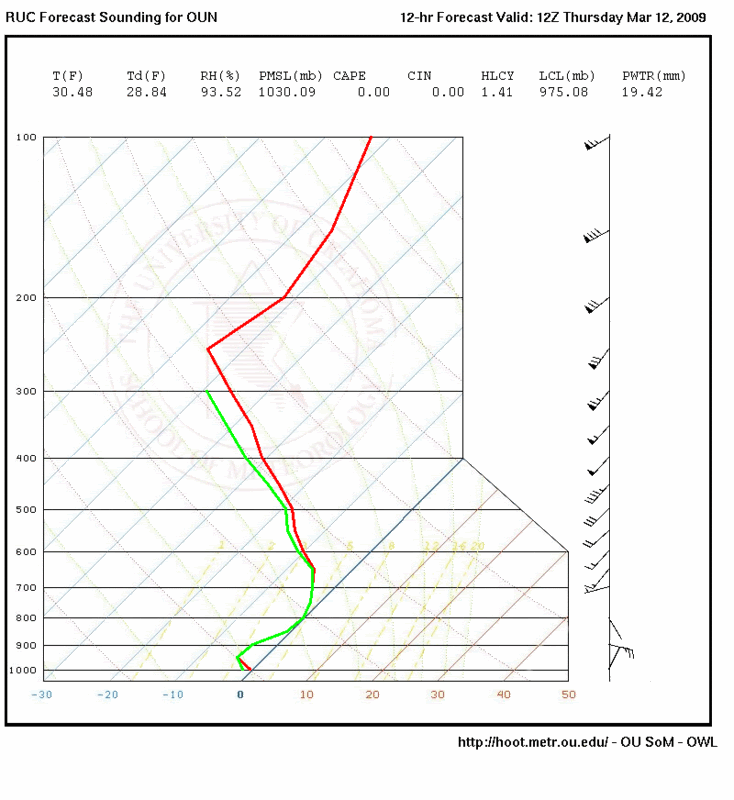
Forecasted soundings are looking good for wintry precipitation in and around Oklahoma City tomorrow morning...
00z RUC for Thursday morning (7am):
00z NAM for Thursday morning (10am):
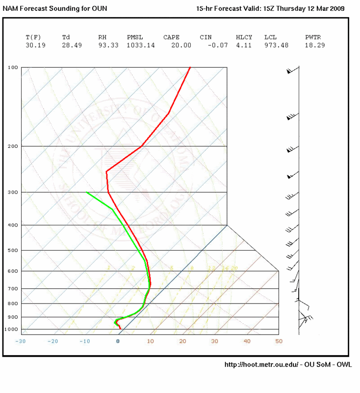
UPDATE (after the event): These skew-T's wound up being slightly too cool. In reality, there was a small warm layer present, which was responsible for keeping most areas from Oklahoma City southward in freezing rain and sleet instead of pure snow.
00z RUC for Thursday morning (7am):
00z NAM for Thursday morning (10am):
UPDATE (after the event): These skew-T's wound up being slightly too cool. In reality, there was a small warm layer present, which was responsible for keeping most areas from Oklahoma City southward in freezing rain and sleet instead of pure snow.
Last edited by Extremeweatherguy on Thu Mar 12, 2009 3:31 pm, edited 1 time in total.
0 likes
Who is online
Users browsing this forum: No registered users and 69 guests