By a week from today according to the GFS model, 500 mb heights in central North America become from 1.5 to 2.0 standard deviations above normal all the way from central Mexico to central Manitoba. There will be below to much below normal heights in Alaska and the eastern United States. No arctic air in Texas would result from that pattern.
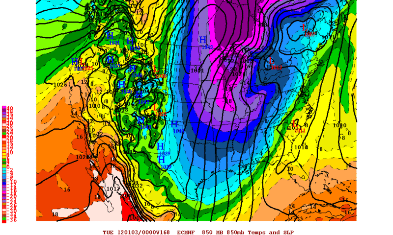
But the high res ECMWF has the ridge farther west, with the long wave trough anchored in the Missouri Valley, and 850 mb temperatures up to 2 standard deviations below normal in Texas. The 0 degree isotherm extends from Beaumont to Houston to Austin to Lubbock, with -5 degrees from Tyler to Dallas to Wichita Falls.
Texas Winter 2011-2012...
Moderator: S2k Moderators
Forum rules
 The posts in this forum are NOT official forecast and should not be used as such. They are just the opinion of the poster and may or may not be backed by sound meteorological data. They are NOT endorsed by any professional institution or STORM2K.

The posts in this forum are NOT official forecast and should not be used as such. They are just the opinion of the poster and may or may not be backed by sound meteorological data. They are NOT endorsed by any professional institution or STORM2K.
-
Portastorm

- Storm2k Moderator

- Posts: 9954
- Age: 63
- Joined: Fri Jul 11, 2003 9:16 am
- Location: Round Rock, TX
- Contact:
Re: Texas Winter 2011-2012...
austinrunner wrote:By a week from today according to the GFS model, 500 mb heights in central North America become from 1.5 to 2.0 standard deviations above normal all the way from central Mexico to central Manitoba. There will be below to much below normal heights in Alaska and the eastern United States. No arctic air in Texas would result from that pattern.
But the high res ECMWF has the ridge farther west, with the long wave trough anchored in the Missouri Valley, and 850 mb temperatures up to 2 standard deviations below normal in Texas. The 0 degree isotherm extends from Beaumont to Houston to Austin to Lubbock, with -5 degrees from Tyler to Dallas to Wichita Falls.
I assume you're referring to the 0z runs? Not much consistency from the GFS, I'm afraid. Compare the 500mb pattern from the 0z @ 180 hours to the 12z @ 168 hrs ... we go from a trough in the East and ridging out west to a straight west-to-east zonal flow across the continental US. I'll be curious to see what the 12z Euro does.
FWIW, the 0z Canadian (CMC) and the UKMET also look a lot like the 0z Euro run depicting the pattern this time next week.
0 likes
Any forecasts under my name are to be taken with a grain of salt. Get your best forecasts from the National Weather Service and National Hurricane Center.
-
GRAYSONCO.WX
- Category 1

- Posts: 450
- Joined: Thu Jan 06, 2011 4:29 pm
- Location: Denison, Texas
Re: Texas Winter 2011-2012...
It appears that some light returns are starting to show up directly under the low that's moving our way. Any thoughts on this system?
0 likes

Re: Texas Winter 2011-2012...
GRAYSONCO.WX wrote:It appears that some light returns are starting to show up directly under the low that's moving our way. Any thoughts on this system?
Atmosphere is very dry and worked up from over the weekend. And frankly temps/dewpoints are very high for any snow event. I would be surprised if anyone saw drizzle nonetheless snow.
Looks dry heading into the New Years. Next cold wave probably heads more east/southeast than our direction so some nice weather with cool nights to New Years! Take it and enjoy it before we head into the meat of winter average wise!
0 likes
The above post and any post by Ntxw is NOT an official forecast and should not be used as such. It is just the opinion of the poster and may or may not be backed by sound meteorological data. It is NOT endorsed by any professional institution including Storm2k. For official information, please refer to NWS products.
Help support Storm2K!
-
TeamPlayersBlue

- Category 5

- Posts: 3524
- Joined: Tue Feb 02, 2010 1:44 am
- Location: Denver/Applewood, CO
What model would you guys trust after the GFS and the Euro? The GFS has gone bonkers this year. The Euro looks more believable right now, but is there a third model that we can look at that has credibility?
0 likes
Personal Forecast Disclaimer:
The posts in this forum are NOT official forecast and should not be used as such. They are just the opinion of the poster and may or may not be backed by sound meteorological data. They are NOT endorsed by any professional institution or storm2k.org. For official information, please refer to the NHC and NWS products.
The posts in this forum are NOT official forecast and should not be used as such. They are just the opinion of the poster and may or may not be backed by sound meteorological data. They are NOT endorsed by any professional institution or storm2k.org. For official information, please refer to the NHC and NWS products.
Re:
TeamPlayersBlue wrote:What model would you guys trust after the GFS and the Euro? The GFS has gone bonkers this year. The Euro looks more believable right now, but is there a third model that we can look at that has credibility?
Imo this is what I would look for in that order
Euro-very good within 3-5 days, seldom flip flops
Euro Ensembles are often good for looking at long term trends
Ukmet (though data is limited)
GFS ensembles
GFS
Canadian/CMC/GGEM (at times can outdo GFS, good for verification vs other models, Wxman says look for shortwaves via this guidance. Often is too cold though)
NAM (is high resolution like euro so looking for moisture/qpf under 24 hours is good)
HRW hi resolution like the nam is good within 12-24 hours
RUC/Rapid Family good for live or within 12 hours.
Common sites often used:
http://raleighwx.americanwx.com/models.html - Has basically every model
http://www.meteo.psu.edu/~gadomski/ewall.html - Same and if you know how to read it very simple for basic user
http://www.wxcaster.com/models_main.htm - bit more complex but has cool detailed stuff like snow maps
http://www.ecmwf.int/ - Public site for Euro
http://www.weatheroffice.gc.ca/canada_e.html-Environment Canada
http://www.weatheroffice.gc.ca/model_forecast/global_e.html - Op Canadian model
http://mag.ncep.noaa.gov/NCOMAGWEB/appcontroller - Ncep's American models
http://www.cpc.ncep.noaa.gov/ - Climate prediction center, has Nino status and teleconnections/MJO
0 likes
The above post and any post by Ntxw is NOT an official forecast and should not be used as such. It is just the opinion of the poster and may or may not be backed by sound meteorological data. It is NOT endorsed by any professional institution including Storm2k. For official information, please refer to NWS products.
Help support Storm2K!
Help support Storm2K!


Re:
Snowshoe wrote:Well this place is going to be boring for a while! Hopefully talk to you guys soon:(
I know and it is depressing. Is there nothing in the long range even worth discussing? No winter for the entire lower 48 so far this year. Yes, some places have seen a little winter but overall this season has been a big bust nation wide. I'm not throwing in the towel yet as much of winter remains. Please Old Man Winter, send us something.
0 likes

Re: Texas Winter 2011-2012...
We'll have something to discuss before you know it! It probably won't be for a couple of weeks, but it will come.
0 likes


Re: Texas Winter 2011-2012...
Well last three runs or so extremely lalala land GFS is trying to hint at a return of split flow pattern, around the 7th of January. Will just have to see if it continues that trend. As far as GFS goes I see nothing earth shattering till then
0 likes
Re: Re:
gpsnowman wrote:Snowshoe wrote:Well this place is going to be boring for a while! Hopefully talk to you guys soon:(
I know and it is depressing. Is there nothing in the long range even worth discussing? No winter for the entire lower 48 so far this year. Yes, some places have seen a little winter but overall this season has been a big bust nation wide. I'm not throwing in the towel yet as much of winter remains. Please Old Man Winter, send us something.
February is our month. At least it has been the past several years. Realistically not much happened aside from a few blips last year or even 09 (it was split between western/eastern area snows here and there not metro/state wide) until Feb! Once that month passes, then we can panic
0 likes
The above post and any post by Ntxw is NOT an official forecast and should not be used as such. It is just the opinion of the poster and may or may not be backed by sound meteorological data. It is NOT endorsed by any professional institution including Storm2k. For official information, please refer to NWS products.
Help support Storm2K!
Help support Storm2K!
-
austinrunner
Re: Texas Winter 2011-2012...
austinrunner wrote:By a week from today according to the GFS model, 500 mb heights in central North America become from 1.5 to 2.0 standard deviations above normal all the way from central Mexico to central Manitoba. There will be below to much below normal heights in Alaska and the eastern United States. No arctic air in Texas would result from that pattern.
But the high res ECMWF has the ridge farther west, with the long wave trough anchored in the Missouri Valley, and 850 mb temperatures up to 2 standard deviations below normal in Texas. The 0 degree isotherm extends from Beaumont to Houston to Austin to Lubbock, with -5 degrees from Tyler to Dallas to Wichita Falls.
According to the 12/27 00Z GFS model run, 500 mb heights in most of Texas on 2 January will be 2 standard deviations above normal, with above normal heights extending from Central America all the way to northern Alberta. Below to much below normal heights will be in Alaska (1.5 standard deviations), off the US west coast (2 standard deviations), and centered in New England. The 0 degree 850 mb isotherm is no closer to Texas than northern Missouri and southern Nebraska. The GFS ensembles are similar. Again, no arctic air in Texas would result from that pattern.
The 12/26 12Z hi res ECMWF is as discussed above.
0 likes
-
Rgv20

- S2K Supporter

- Posts: 2466
- Age: 39
- Joined: Wed Jan 05, 2011 5:42 pm
- Location: Edinburg/McAllen Tx
Have not had a whole lot of time to check on the models recently but tonight's 0zECMWF brings a pretty good shot of cold air for early next week. It looks like the brunt of the cold air should stay to the east of Texas tho.
0 likes
The following post is NOT an official forecast and should not be used as such. It is just the opinion of the poster and may or may not be backed by sound meteorological data. It is NOT endorsed by any professional institution including storm2k.org For Official Information please refer to the NHC and NWS products.
-
austinrunner
Re: Texas Winter 2011-2012...
There are major differences of opinion among the National Weather Service forecast offices in Texas about whether to go with the ECMWF or GFS solution.
0 likes
-
wxman57

- Moderator-Pro Met

- Posts: 23170
- Age: 68
- Joined: Sat Jun 21, 2003 8:06 pm
- Location: Houston, TX (southwest)
Re: Texas Winter 2011-2012...
A week ago, the Euro was forecasting widespread freezing conditions from TX to FL today/tomorrow. The problem has been a lack of cold air in western Canada. Current Euro is forecasting a freeze down to the Gulf Coast early next week (again), but at the same time it's forecasting temps in western and central Canada to be 20-35 deg above normal. So there's a good chance it's 5-8 deg too cold for temps down south next week.
0 likes
Re: Texas Winter 2011-2012...
Yeah im not buying it either, at least not that cold. The pna spike does allow for cooling like we just had Christmas around new years or just after. At least Alaska is getting cold so maybe that might come down in the future. For now its the battle between gfs and euro mid range which are complete opposites as usual lol.
0 likes
The above post and any post by Ntxw is NOT an official forecast and should not be used as such. It is just the opinion of the poster and may or may not be backed by sound meteorological data. It is NOT endorsed by any professional institution including Storm2k. For official information, please refer to NWS products.
Help support Storm2K!
Help support Storm2K!
-
Portastorm
- Storm2k Moderator
- Posts: 9954
- Age: 63
- Joined: Fri Jul 11, 2003 9:16 am
- Location: Round Rock, TX
- Contact:
Pattern-wise, my pesos are on King Euro. The GFS has flailed about lately like kids at a birthday party trying to hit a pinata.
Interestingly enough, I gotta give props to the NAM for how it handled this past weekend's system. I feel it was the best model within 48-72 hours.
Interestingly enough, I gotta give props to the NAM for how it handled this past weekend's system. I feel it was the best model within 48-72 hours.
0 likes
Any forecasts under my name are to be taken with a grain of salt. Get your best forecasts from the National Weather Service and National Hurricane Center.
-
CaptinCrunch

- S2K Supporter
- Posts: 8776
- Age: 57
- Joined: Mon Nov 03, 2003 4:33 pm
- Location: Kennedale, TX (Tarrant Co.)
La Nina is just now showing her head, even though we will see a cool down across NTX next week we wont see any real winter weather till the mid month rolls around. As others have noted there is just not enough arctic air in western Canada to effect us here in NTX. Until the ridge returns and polor air gets dumped in to NW Canada expect a mild/cool pattern across the southern U.S.
NEW YEARS EVE THRU THE FIRST FEW DAYS OF 2012...MEDIUM RANGE
GUIDANCE INDICATES THAT A LARGE TROUGH WILL BUILD SOUTHEAST AND
COVER MUCH OF THE EASTERN CONUS BY NEW YEARS DAY. THERE ARE
SIGNIFICANT DIFFERENCES REGARDING HOW STRONG AND HOW FAR SOUTH
THIS TROUGH WILL BUILD INTO THE SOUTHERN PLAINS. EITHER WAY
GUIDANCE SENDS A COLD FRONT SOUTH THRU NORTH TX ON NEW YEARS DAY.
AT THIS TIME IT DOES NOT LOOK LIKE THERE WILL BE SUFFICIENT DEEP
LAYER MOISTURE OR UPPER LEVEL SUPPORT OVER NORTH TX TO SUPPORT
SIGNIFICANT PRECIPITATION CHANCES. ANY RAIN SHOWERS WOULD LIKELY
BE RELEGATED TO THE FAR SOUTHEASTERN PORTIONS OF THE FORECAST AREA
WHERE THE DEEPER GULF MOISTURE RESIDES. AT THIS TIME JUST WENT
WITH A 20 PERCENT CHANCE FOR RAIN SHOWERS TO ACCOUNT FOR
PRECIPITATION DEVELOPING ALONG THE FRONT AS IT EXITS THE FORECAST
AREA. WILL REFINE PRECIPITATION CHANCES AS GUIDANCE COMES INTO
BETTER AGREEMENT REGARDING THE STRENGTH OF THIS UPPER TROUGH AND
ITS ASSOCIATED COLD FRONT. TEMPERATURES WILL LIKELY COME BACK DOWN
TO SEASONAL NORMALS OR LOWER FOR THE FIRST COUPLE OF DAYS OF 2012
BEHIND THIS FRONT.
0 likes
For what it's worth the Canadian has jumped ship from the GFS and joined the Euro in an east coast trough, Texas gets a glancing blow of cold.
0 likes
The above post and any post by Ntxw is NOT an official forecast and should not be used as such. It is just the opinion of the poster and may or may not be backed by sound meteorological data. It is NOT endorsed by any professional institution including Storm2k. For official information, please refer to NWS products.
Help support Storm2K!
Help support Storm2K!
Who is online
Users browsing this forum: SnowyOwl31 and 67 guests