Texas Winter 2017-2018
Moderator: S2k Moderators
Forum rules
 The posts in this forum are NOT official forecast and should not be used as such. They are just the opinion of the poster and may or may not be backed by sound meteorological data. They are NOT endorsed by any professional institution or STORM2K.
 The posts in this forum are NOT official forecast and should not be used as such. They are just the opinion of the poster and may or may not be backed by sound meteorological data. They are NOT endorsed by any professional institution or STORM2K.
-
Theepicman116
- Tropical Depression

- Posts: 95
- Age: 26
- Joined: Sat Nov 26, 2016 10:43 pm
- Location: Stephenville
Re: Texas Winter 2017-2018
Freezing rain for the DFW area on Christmas Eve. That’s the GFS model right now. I don’t want to lose power. Some of my presents may require electricity and being charged. 
0 likes
Re: Texas Winter 2017-2018
One thing to consider is that also we could be getting into that mid range period where the models start to lose some of the cold only to pick it up again in the shorter range.
4 likes
-
Ralph's Weather
- S2K Supporter

- Posts: 3371
- Age: 38
- Joined: Fri Dec 13, 2013 11:55 am
- Location: Lindale, TX
- Contact:
Re: Texas Winter 2017-2018
Cpv17 wrote:One thing to consider is that also we could be getting into that mid range period where the models start to lose some of the cold only to pick it up again in the shorter range.
My thoughts also, this is the GFS after all. -EPO means ridging over NW North America. PNA directs that cold with negative sending cold west and positive sending cold east. We are looking at - to even --EPO and = to -PNA. No matter what the model runs show these teleconnections rule in the long range.
2 likes
Follow on Facebook at Ralph's Weather.
- starsfan65
- Category 2

- Posts: 738
- Age: 48
- Joined: Thu Dec 17, 2015 1:18 pm
- Location: Garland,Tx
Re: Texas Winter 2017-2018
Ralph's Weather wrote:Cpv17 wrote:One thing to consider is that also we could be getting into that mid range period where the models start to lose some of the cold only to pick it up again in the shorter range.
My thoughts also, this is the GFS after all. -EPO means ridging over NW North America. PNA directs that cold with negative sending cold west and positive sending cold east. We are looking at - to even --EPO and = to -PNA. No matter what the model runs show these teleconnections rule in the long range.
I don't think they have lost it. In fact getting more resolution closer. The thing that may get them for awhile is the upper flow confuses the models with low level cold on and off as many have posted above. Pretty typical until hi res model range
0 likes
The above post and any post by Ntxw is NOT an official forecast and should not be used as such. It is just the opinion of the poster and may or may not be backed by sound meteorological data. It is NOT endorsed by any professional institution including Storm2k. For official information, please refer to NWS products.
- ThunderSleetDreams
- S2K Supporter

- Posts: 1510
- Age: 43
- Joined: Tue Dec 20, 2011 4:42 pm
- Location: S of Weimar, TX
Re: Texas Winter 2017-2018
Ntxw wrote:Ralph's Weather wrote:Cpv17 wrote:One thing to consider is that also we could be getting into that mid range period where the models start to lose some of the cold only to pick it up again in the shorter range.
My thoughts also, this is the GFS after all. -EPO means ridging over NW North America. PNA directs that cold with negative sending cold west and positive sending cold east. We are looking at - to even --EPO and = to -PNA. No matter what the model runs show these teleconnections rule in the long range.
I don't think they have lost it. In fact getting more resolution closer. The thing that may get them for awhile is the upper flow confuses the models with low level cold on and off as many have posted above. Pretty typical until hi res model range
6z didn’t lose it all. When watching for Winter Weather patterns, my order of reading the models (in terms of importance) goes:
1) MJO forecast
2)Upper air pattern thru the end (on one browser)
3)850 temps (on 2nd browser)
4)Temp output (on 3rd browser)
5) Precip (toggle on 3rd)
2 likes
#NeverSummer
I hibernate when it gets above 75 degrees!
I hibernate when it gets above 75 degrees!
- ThunderSleetDreams
- S2K Supporter

- Posts: 1510
- Age: 43
- Joined: Tue Dec 20, 2011 4:42 pm
- Location: S of Weimar, TX
Re: Texas Winter 2017-2018
Take a look at this and tell me it isn’t going to get cold, and Support it (you can’t BTW)

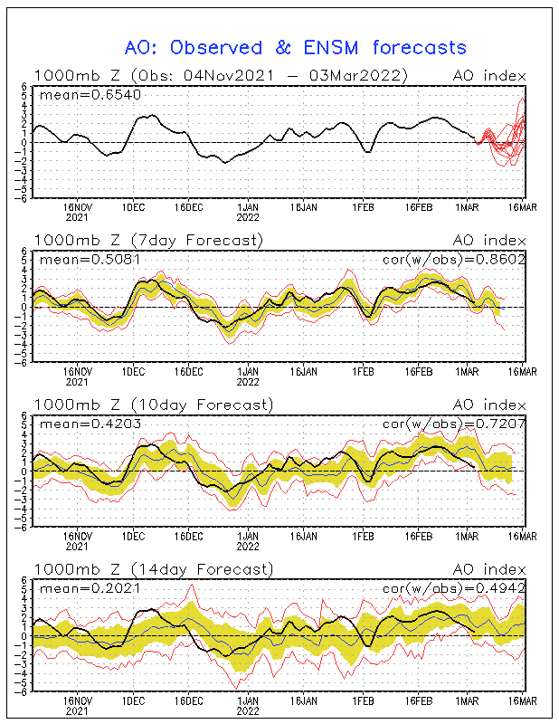
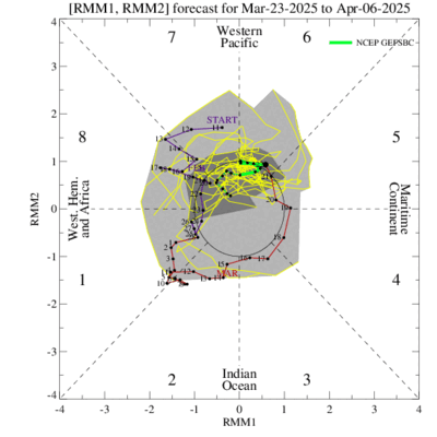
1) - - EPO
2) PNA moves toward neutral
3) I see no advertisement of an anomalous SE ridge in the above like the models want to output in their operational


1) - - EPO
2) PNA moves toward neutral
3) I see no advertisement of an anomalous SE ridge in the above like the models want to output in their operational
1 likes
#NeverSummer
I hibernate when it gets above 75 degrees!
I hibernate when it gets above 75 degrees!
Re: Texas Winter 2017-2018
ThunderSleetDreams wrote:Take a look at this and tell me it isn’t going to get cold, and Support it (you can’t BTW)
https://www.esrl.noaa.gov/psd/forecasts ... ndices.png
http://www.cpc.ncep.noaa.gov/products/p ... .sprd2.gif
http://www.cpc.ncep.noaa.gov/products/p ... _small.gif
1) - - EPO
2) PNA moves toward neutral
3) I see no advertisement of an anomalous SE ridge in the above like the models want to output in their operational
The SE ridge is a downstream effect of the PNA. When the -PNA exist, there is a SE ridge because the western trough kicks up the ridge to the east. +PNA is the reverse. Nina climo is - while Nino climo is +
1 likes
The above post and any post by Ntxw is NOT an official forecast and should not be used as such. It is just the opinion of the poster and may or may not be backed by sound meteorological data. It is NOT endorsed by any professional institution including Storm2k. For official information, please refer to NWS products.
- ThunderSleetDreams
- S2K Supporter

- Posts: 1510
- Age: 43
- Joined: Tue Dec 20, 2011 4:42 pm
- Location: S of Weimar, TX
Re: Texas Winter 2017-2018
Ntxw wrote:ThunderSleetDreams wrote:Take a look at this and tell me it isn’t going to get cold, and Support it (you can’t BTW)
https://www.esrl.noaa.gov/psd/forecasts ... ndices.png
http://www.cpc.ncep.noaa.gov/products/p ... .sprd2.gif
http://www.cpc.ncep.noaa.gov/products/p ... _small.gif
1) - - EPO
2) PNA moves toward neutral
3) I see no advertisement of an anomalous SE ridge in the above like the models want to output in their operational
The SE ridge is a downstream effect of the PNA. When the -PNA exist, there is a SE ridge because the western trough kicks up the ridge to the east. +PNA is the reverse. Nina climo is - while Nino climo is +
I realize that. My point is (and I should’ve spelled this out better) the GFS op keeps the ridge well past the move to neutral and positive. It doesn’t make sense.
0 likes
#NeverSummer
I hibernate when it gets above 75 degrees!
I hibernate when it gets above 75 degrees!
- MississippiWx
- S2K Supporter

- Posts: 1720
- Joined: Sat Aug 14, 2010 1:44 pm
- Location: Hattiesburg, Mississippi
Re: Texas Winter 2017-2018
Can you Texas people allow the Southeast ridge to not be as strong?  We don't want another 80 degree Christmas.
1 likes
This post is not an official forecast and should not be used as such. It is just the opinion of MississippiWx and may or may not be backed by sound meteorological data. It is not endorsed by any professional institution including storm2k.org. For Official Information please refer to the NHC and NWS products.
- wxman57
- Moderator-Pro Met

- Posts: 23170
- Age: 68
- Joined: Sat Jun 21, 2003 8:06 pm
- Location: Houston, TX (southwest)
Re: Texas Winter 2017-2018
12Z GFS is much faster with the cold air arriving in SE Texas - Friday morning, the 22nd.
0 likes
- spencer817
- Tropical Storm

- Posts: 197
- Age: 27
- Joined: Thu Nov 17, 2016 3:22 pm
- Location: Coppell, TX
Re: Texas Winter 2017-2018
Precip basically is avoiding DFW this run, another S TX event this run.
Last edited by spencer817 on Thu Dec 14, 2017 11:40 am, edited 1 time in total.
0 likes
I'm going to go to school for this stuff 
- ThunderSleetDreams
- S2K Supporter

- Posts: 1510
- Age: 43
- Joined: Tue Dec 20, 2011 4:42 pm
- Location: S of Weimar, TX
Re: Texas Winter 2017-2018
That’s 19 in a row and 20 of 22 showing an arctic front late next week. About 80% of the runs show a Texas storm.
1 likes
#NeverSummer
I hibernate when it gets above 75 degrees!
I hibernate when it gets above 75 degrees!
-
stormlover2013
Re: Texas Winter 2017-2018
moisture prob will be there but I don't know if it will be cold enough...
0 likes
Re: Texas Winter 2017-2018
No major cold being shown on the 12z. Has SE TX staying above freezing through 240 hours. Plenty of moisture though.
0 likes
- ThunderSleetDreams
- S2K Supporter

- Posts: 1510
- Age: 43
- Joined: Tue Dec 20, 2011 4:42 pm
- Location: S of Weimar, TX
Re: Texas Winter 2017-2018
stormlover2013 wrote:moisture prob will be there but I don't know if it will be cold enough...
Actual always runs colder than modeled. If this was real time I’d say there would be a high likelihood.
1 likes
#NeverSummer
I hibernate when it gets above 75 degrees!
I hibernate when it gets above 75 degrees!
- ThunderSleetDreams
- S2K Supporter

- Posts: 1510
- Age: 43
- Joined: Tue Dec 20, 2011 4:42 pm
- Location: S of Weimar, TX
Re: Texas Winter 2017-2018
Cpv17 wrote:No major cold being shown on the 12z. Has SE TX staying above freezing through 240 hours. Plenty of moisture though.
Again, it shows an Arctic front reversing for about 12-18 hours the. The secondary reinforcing shot of cold air comes through and knocks everyone below freezing at 300.
Arctic fronts don’t back up and the ridge just isn’t that strong if you’re to believe the TI.
1 likes
#NeverSummer
I hibernate when it gets above 75 degrees!
I hibernate when it gets above 75 degrees!
-
weatherdude1108
- Category 5

- Posts: 4228
- Joined: Tue Dec 13, 2011 1:04 pm
- Location: Northwest Austin/Cedar Park, TX
Re: Texas Winter 2017-2018
Ummmmm, this could be concerning in my part of Texas. 
 It looks like it would be an ICE Christmas instead of a white Christmas. We are supposed to be traveling from Austin to San Antonio on Christmas morning. May be a "slushy" drive there(?). Crazy models!


 It looks like it would be an ICE Christmas instead of a white Christmas. We are supposed to be traveling from Austin to San Antonio on Christmas morning. May be a "slushy" drive there(?). Crazy models!


1 likes
The preceding post is NOT an official forecast, and should not be used as such. It is only the opinion of the poster and may or may not be backed by sound meteorological data. It is NOT endorsed by any professional institution including storm2k.org. For Official Information please refer to the NHC and NWS products.
- wxman57
- Moderator-Pro Met

- Posts: 23170
- Age: 68
- Joined: Sat Jun 21, 2003 8:06 pm
- Location: Houston, TX (southwest)
Re: Texas Winter 2017-2018
Note that if Arctic air does make it south into Texas around the 22nd, the GFS will always have a problem handling the southward extent of the cold air. I can see that in the 23rd-25th time period. It's trying to drive the Arctic air northward. That would be unlikely. What this means is that temperatures across southeast and south Texas could be colder than the GFS is indicating. Now that's not my forecast, as it is way too far out to have any confidence at all in the temps/precip next weekend.
1 likes
- wxman57
- Moderator-Pro Met

- Posts: 23170
- Age: 68
- Joined: Sat Jun 21, 2003 8:06 pm
- Location: Houston, TX (southwest)
Re: Texas Winter 2017-2018
Inches of freezing rain across the Hill Country (12Z GFS) would not be good. Perhaps they would have power restored by spring, though...
1 likes
Who is online
Users browsing this forum: No registered users and 39 guests


