#1600 Postby srainhoutx » Sat Jan 02, 2016 2:37 pm
I suspect the sub tropical jet with its embedded disturbances will not be an issues near the day 10-15 range. The MJO via all the reliable guidance should be entering a favorable Phase 8 during that time and even with the lag time of a Convectively Coupled Kelvin Wave moving East of the dateline, we likely will see an Eastern Pacific tropical connection. The Teleconnection Indices all favor the mid January timeframe for cold weather along and East of the Continental Divide. We really do not need a truly dry Arctic airmass to drop temperatures into the teens. The advertised pattern favors Gulf Coastal low/trough development, so I believe those looking for some wintry mischief potential may not have to wait too much longer. There is certainly not much of any moderation expected during the first couple of weeks in January. The warmth of December is long gone until Spring.
Prognostic Discussion for Experimental Week 3-4 Outlook
NWS Climate Prediction Center College Park MD
300PM EST Fri Jan 01 2016
Week 3-4 Forecast Discussion Valid Sat Jan 16 2016-Fri Jan 29 2016
A complicated short term climate scenario is expected to continue to evolve over the next few weeks resulting in a challenging Week 3-4 outlook. Along with background strong El Nino conditions, a robust and coherent MJO continues to propagate eastward across the Tropics. The enhanced convective phase of this MJO is currently centered across the west central Pacific and is now constructively interfering with the low frequency El Nino base state. In addition to these factors, the AO is forecast by some of the model guidance to become negative (for a substantial period) for the first time this late autumn and winter during the upcoming preceding two week period. This forecast of the AO is consistent with the evolution of the ongoing MJO event and is likely to persist into the Week 3-4 outlook period and favors anomalous troughing across areas of eastern North America especially during Week-3. The above noted pattern change across the east (forecast to occur beginning in the Week-2 period) represents a major change from what has been observed on average to date this winter.
Dynamical model guidance is in generally good agreement among the CFS, ECMWF and JMA solutions across the Pacific Ocean and western North America and depicts positive height departures across the northwest Pacific Ocean, anomalous troughing west of Alaska southeastward to just of the coast of the western CONUS and anomalous ridging over eastern Alaska and western Canada. Across the eastern CONUS, substantial negative height departures are forecast by the CFS and ECMWF over the Southeast and mid Atlantic. In this area, the JMA solution diverges significantly from the other models and indicates considerably less troughing and even positive height departures across eastern Canada and parts of the northern CONUS. This solution was considered an outlier and discounted due to its inconsistency with the previously described MJO and AO evolution and their associated typical impacts.
The Week 3-4 outlook this week was prepared with considerations from background El Nino conditions, lagged impacts associated with the ongoing MJO, prospects for a negative AO phase continuing into the outlook period and available statistical and dynamical model guidance.
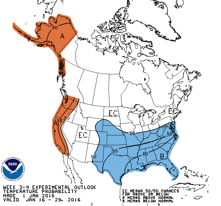
The temperature outlook depicts below normal temperatures favored for an area stretching from the central and southern High Plains eastward across the central and lower Mississippi Valley, lower Ohio Valley, Southeast and mid-Atlantic. The highest probabilities are indicated across the Southeast where lagged impacts of the MJO, negative AO and dynamical model guidance are in the best agreement. Above normal temperatures are more likely along the West coast of the CONUS at modest probabilities and this area extends northward to include Alaska. Areas within this highlighted region are based, to varying degrees, on local SSTs, El Nino and MJO impacts and statistical and dynamical model guidance. Background El Nino conditions may temper cold temperatures across parts of the northern CONUS so EC or equal chances is forecast in this region.
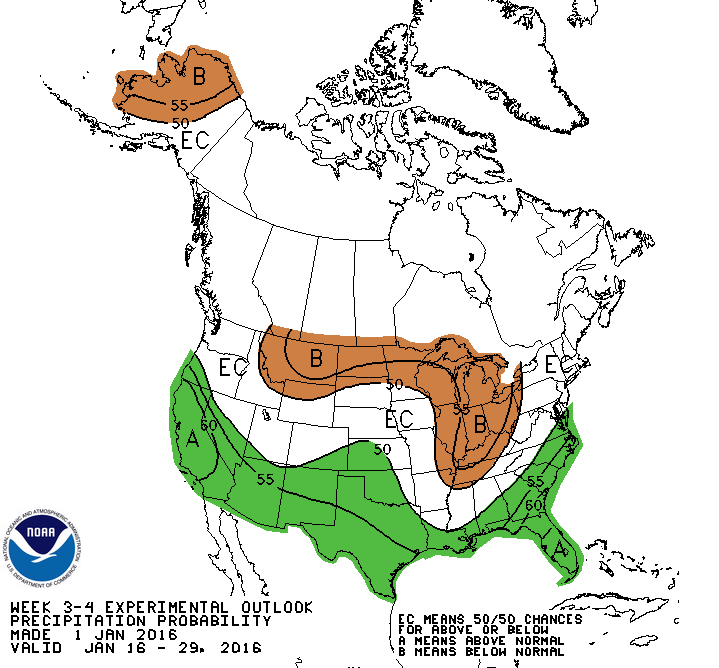
For precipitation, there are elevated odds for above-median precipitation for much of the West coast, especially north-central California eastward across the Southwest to parts of the southern High Plains and along the Gulf coast, Southeast and lower mid-Atlantic. The highest probabilities extend across the bottom half of the Florida Peninsula. Below median precipitation is highlighted from the northern Rockies eastward across the northern Plains and portions of the Great Lakes southward to include parts of the Ohio and Tennessee Valley. The highlighted areas are primarily based on statistical forecast guidance that incorporates information on ENSO, MJO and trends with adjustments made to some areas (primarily the central west coast) by dynamical model guidance. In the aforementioned region, the model guidance was consistent in indicating above median precipitation during the outlook period.
Above average temperatures and below median precipitation is forecast for Hawaii during the period.
Last edited by
srainhoutx on Sat Jan 02, 2016 3:12 pm, edited 1 time in total.
0 likes
Carla/Alicia/Jerry(In The Eye)/Michelle/Charley/Ivan/Dennis/Katrina/Rita/Wilma/Ike/Harvey
Member: National Weather Association
Wx Infinity Forums
http://wxinfinity.com/index.phpFacebook.com/WeatherInfinity
Twitter @WeatherInfinity


 The posts in this forum are NOT official forecast and should not be used as such. They are just the opinion of the poster and may or may not be backed by sound meteorological data. They are NOT endorsed by any professional institution or STORM2K.


