I don’t think expect to see any winter weather here locally. Heck, maybe not even a freeze.
I think that isn’t a bad mindset for anyone to have. Expect nothing but if you get something, it’ll be a pleasant surprise. If you follow this closely or look forward to this possible pattern change, expect BIG emotional swings.
I’ve been there before. It’s hard.
Texas Winter 2019-2020
Moderator: S2k Moderators
Forum rules
 The posts in this forum are NOT official forecast and should not be used as such. They are just the opinion of the poster and may or may not be backed by sound meteorological data. They are NOT endorsed by any professional institution or STORM2K.

The posts in this forum are NOT official forecast and should not be used as such. They are just the opinion of the poster and may or may not be backed by sound meteorological data. They are NOT endorsed by any professional institution or STORM2K.
-
Haris

- Category 5

- Posts: 1814
- Joined: Mon Nov 27, 2017 8:19 pm
- Location: ( Bee Cave) West Austin, Texas
Re: Texas Winter 2019-2020
4 likes
Weather geek and a storm spotter in West Austin. Not a degreed meteorologist. Big snow fan. Love rain and cold! Despise heat!
-
Brent
- S2K Supporter

- Posts: 38716
- Age: 37
- Joined: Sun May 16, 2004 10:30 pm
- Location: Tulsa Oklahoma
- Contact:
Re: Texas Winter 2019-2020
I don't even see a storm at all for the 35 corridor on the Euro 
1 likes
#neversummer
-
Ralph's Weather
- S2K Supporter
- Posts: 3371
- Age: 38
- Joined: Fri Dec 13, 2013 11:55 am
- Location: Lindale, TX
- Contact:
Re: Texas Winter 2019-2020
06Z GFS is not great but better than 00Z. 00Z GFS ensembles are a mixed bag. Overall GFS is the least progressive with the surface high vs Euro and Canadian. Still many model runs before the event. I need to make a call by Friday on whether my meetings in Houston Tuesday need to be rescheduled. I am not gonna be confident in the forecast until Monday though.
0 likes
Follow on Facebook at Ralph's Weather.
-
Yukon Cornelius
- S2K Supporter
- Posts: 1838
- Age: 42
- Joined: Thu Dec 20, 2012 9:23 pm
- Location: Dean, TX/Westcliffe, CO
Re: Texas Winter 2019-2020
Morning after morning of extremely dense fog. I don’t think I’ve ever seen this many days with consecutive 0 visibility fog.
0 likes
#neversummer

Re: Texas Winter 2019-2020
Low temperatures across southeast Texas this morning are well above 30 degrees above normal. You’ll never see them 30+ degrees below normal, but above, sure no problem.
2 likes
-
orangeblood
- S2K Supporter
- Posts: 3895
- Joined: Tue Dec 15, 2009 6:14 pm
- Location: Fort Worth, TX
Re: Texas Winter 2019-2020
Even though the Operationals are all over the place for next week...the Ensembles continue to become more aggressive with wintry precip for not only next week but into the 10-15 day time frame as well.

5 likes
-
wxman57

- Moderator-Pro Met

- Posts: 23170
- Age: 68
- Joined: Sat Jun 21, 2003 8:06 pm
- Location: Houston, TX (southwest)
Re: Texas Winter 2019-2020
Portastorm wrote:...snip...
Perhaps we can squeeze out a good second half of "winter" and add some serious pages to this thread. And make our friend wxman57 miserable in the process!
The pattern just doesn't look right for significant frozen precip across your area or mine (Houston) next week. My two cold-mongering coworkers are talking about a pattern change late this month into February. We shall see. I'm not seeing anything to indicate a major change. Still have to get through two more months, though. Meanwhile, it was 79 degrees in Houston yesterday, with a little bit of afternoon sun when the fog burned off. Record high yesterday was 82. Today's record is only 79, which is one of a very few days of the year when Houston's record high is below 80.
Meanwhile, I returned from the U.S.-Canadian border yesterday afternoon. Data on upgrades to my wall went into the 00Z model runs.
3 likes
-
weatherdude1108
- Category 5
- Posts: 4228
- Joined: Tue Dec 13, 2011 1:04 pm
- Location: Northwest Austin/Cedar Park, TX
Re: Texas Winter 2019-2020
EWX alludes to the models predicting Winter type events that have not happened.
000
FXUS64 KEWX 151014
AFDEWX
Area Forecast Discussion
National Weather Service Austin/San Antonio TX
414 AM CST Wed Jan 15 2020
.SHORT TERM (Today through Thursday)...
Fog continues to expand across south central Texas this morning.
While we are seeing a subtle increase in southerly winds and mixing,
suspect there are a few areas of locally dense fog ongoing from the
coastal plains westward across the I-35 corridor and into the Hill
Country and southern Edwards Plateau. With saturated conditions
remaining in place through mid-morning, we have issued a Dense Fog
Advisory for most of south central Texas through 9 AM. If mixing
commences a little sooner, the dense fog may not persist as long as
currently forecast. Otherwise, expect warm and humid conditions today
with highs well above normal. We should see afternoon readings peak
in the 70s to lower 80s. We could be close to record highs along the
I-35 corridor.
As for rain chances today, we have mentioned a low chance across Val
Verde county as southwest flow aloft begins to increase in advance
of an upper trough. Elsewhere, rain chances should remain too low to
mention in the forecast. For late tonight into the very early
morning hours on Thursday, a cold front will reach the Hill Country
and southern Edwards Plateau. The models continue to have differing
opinions with regards to the southward progress of this front. Will
prefer to side with the higher resolution models in bringing this
shallow front farther south into the region throughout the daytime
hours on Thursday. This will make for a very tricky temperature
forecast and additional adjustments will be needed. For now, we will
show the coolest temperatures across the southern Edwards Plateau
and Hill Country. Areas farther south will see warmer readings as
the leading edge of the front will have a tough time making
southward progress into the increasingly warm and humid air mass.
Rain chances will be on the increase Thursday, especially over the
southern Edwards Plateau westward to the Rio Grande. Model
precipitation forecasts continue to trend upward across this region,
especially in the afternoon hours. We could see some pockets of
locally heavy rainfall given well above normal moisture and we will
continue to mention this in the Hazardous Weather Outlook.
&&
.LONG TERM (Thursday Night through Tuesday)...
The cold front stalls over southern parts of our area Thursday night
and then drifts back to the north on Friday. Upward forcing by weak
mid level shortwaves and the frontal surface of an unseasonably moist
airmass generates scattered to numerous showers Thursday night into
Friday. Mainly elevated instability keeps thunderstorms isolated to
widely scattered. The greatest coverage and highest rainfall amounts
will be over the Edwards Plateau to along the Rio Grande where spots
of locally heavy rains are possible due to 925 to 850 MB convergence
in that area. An upper level trough axis brings another cold front
across our area late Friday night and Saturday. Upward forcing along
and ahead of these features keep showers and isolated thunderstorms
going, then they move off to the south and east with their passage on
Saturday. Temperatures average well above normal until the frontal
passage on Saturday.
The frontal passage turns temperatures much colder with well below
normal temperatures through at least the middle of next week. The
passage of mid level shortwaves generate isolated showers Sunday
night into Monday and Tuesday into Wednesday. Some forecast soundings
indicate a potential of winter type precipitation over parts of the
Hill Country into Central Texas where temperatures briefly drop to
freezing early Tuesday morning while the showers begin to redevelop.
Due to uncertainty in the models and it being a few days away, will
keep it as liquid, for now. The GFS and to a lesser extent other
models have forecast a potential for winter type precipitation for
parts of our area several days ahead for parts our area already this
winter. Those events have not happened.
0 likes
The preceding post is NOT an official forecast, and should not be used as such. It is only the opinion of the poster and may or may not be backed by sound meteorological data. It is NOT endorsed by any professional institution including storm2k.org. For Official Information please refer to the NHC and NWS products.
-
Ralph's Weather
- S2K Supporter
- Posts: 3371
- Age: 38
- Joined: Fri Dec 13, 2013 11:55 am
- Location: Lindale, TX
- Contact:
Re: Texas Winter 2019-2020
06Z GFS ensembles still look good for next week's N TX snow and for the following week also. This paatern is ripe for multiple light snow events for the I-20 corridor with 1040 surface high over Iowa and an active STJ providing tons of moisture throughout the column. The surface high location is key though if over Kansas then there will be too much dry air and if over Kentucky then not enough surface cold. We need the surface high near the Mississippi River over Iowa or Illinois. If we get the surface high in the right spot then I see the epicenter of the snow next week over DFW. The GFS is far and away my model of choice as the Euro has struggled this winter ad last winter and the Canadian is even more wild most times. With the GFS ensemble members nearly unanimous run after run on N TX snow I am on board cautiously.
0 likes
Follow on Facebook at Ralph's Weather.
-
bubba hotep

- S2K Supporter
- Posts: 6012
- Joined: Wed Dec 28, 2016 1:00 am
- Location: Collin County Texas
Re: Texas Winter 2019-2020
Not surprising to see the operational models drop the snow event for next week since the ensemble support has been hovering around 35%. The 00z super was 37% but the 00z/06z blend jumped to 44% driven by the GEFS. So, even with a bit of an increase in ensemble support we are still below 50%, so still a long shot event. It will be interesting to see if the GEFS trend holds and if the EPS joins it. Maybe a better look on the 12z ops based on the bump in the 00z/06z blend?
Last edited by bubba hotep on Wed Jan 15, 2020 9:46 am, edited 1 time in total.
2 likes
Winter time post are almost exclusively focused on the DFW area.
-
CaptinCrunch

- S2K Supporter
- Posts: 8776
- Age: 57
- Joined: Mon Nov 03, 2003 4:33 pm
- Location: Kennedale, TX (Tarrant Co.)
Re: Texas Winter 2019-2020
wxman57 wrote:Portastorm wrote:...snip...
Perhaps we can squeeze out a good second half of "winter" and add some serious pages to this thread. And make our friend wxman57 miserable in the process!
Meanwhile, I returned from the U.S.-Canadian border yesterday afternoon. Data on upgrades to my wall went into the 00Z model runs.
unfortunately U.S and Canadian officials have deemed your wall unsafe and a potential hazard to winter lovers in Texas. Immediate demolition of said wall has commenced and data reflecting this removal should make into tomorrows or fridays 00Z model run.
yours truly
6 likes
-
Ralph's Weather
- S2K Supporter
- Posts: 3371
- Age: 38
- Joined: Fri Dec 13, 2013 11:55 am
- Location: Lindale, TX
- Contact:
Re: Texas Winter 2019-2020
bubba hotep wrote:Not surprising to see the operational models drop the snow event for next week since the ensemble support has been hovering around 35%. The 00z super was 37% but the 00z/06z blend jumped to 44% driven by the GEFS. So, even with a bit of an increase in ensemble support we are still below 50%, so still a long shot event. It will be interesting to see if the GEFS trend holds and if the EPS joins it. Maybe a better look on the 12z ops based on the bump in the 00z/06z blend?
What is your criteria for ensemble support? On 06Z I count 80% of GFS members as having snow in N TX and 55% with >1" in N TX for next week. For E TX, I count 90% with some snow and 25% with >1". For C TX, I count 50% with some snow and 15% with >1". For SE TX I count 65% with some snow and 10% with > 1". This is per CoD.
1 likes
Follow on Facebook at Ralph's Weather.
-
wxman57
- Moderator-Pro Met
- Posts: 23170
- Age: 68
- Joined: Sat Jun 21, 2003 8:06 pm
- Location: Houston, TX (southwest)
Re: Texas Winter 2019-2020
I notice that the 12Z GFS puts the high center MUCH farther south and east than previous runs for Monday evening. SW Missouri at 1035mb vs central South Dakota at 1046mb. Drier air across Texas early next week. By noon Tuesday, 12Z GFS has a 1029mb over Louisiana vs. previous run with a 1039mb high over Iowa. South winds with warming temps and light-moderate rain across Texas Wednesday. No ice anywhere close to TX.
0 likes
-
Ralph's Weather
- S2K Supporter
- Posts: 3371
- Age: 38
- Joined: Fri Dec 13, 2013 11:55 am
- Location: Lindale, TX
- Contact:
Re: Texas Winter 2019-2020
12Z GFS continues the trend of the past couple runs towards a more progressive surface high next week. The STJ is no longer shown to be straight firehose out of the eastern Pacific.
0 likes
Follow on Facebook at Ralph's Weather.
-
rwfromkansas
- Category 5
- Posts: 3009
- Joined: Sat Aug 27, 2005 12:47 am
- Location: North Fort Worth
-
TeamPlayersBlue

- Category 5
- Posts: 3524
- Joined: Tue Feb 02, 2010 1:44 am
- Location: Denver/Applewood, CO
Re: Texas Winter 2019-2020
Not a good trend. Lets see if the euro will save us. I expected winter to be back and forth with cold and hot, but these warm spells are lasting longer than though. Warm pool is disappointing us again. So different from 13-14. Makes you wonder what other factors occurred that year which led to so many arctic fronts, because clearly it wasnt just the warm pool.
I understand there are so many variables that occur in weather but we thought the warm pool bringing down cold air was a given.
I understand there are so many variables that occur in weather but we thought the warm pool bringing down cold air was a given.
0 likes
Personal Forecast Disclaimer:
The posts in this forum are NOT official forecast and should not be used as such. They are just the opinion of the poster and may or may not be backed by sound meteorological data. They are NOT endorsed by any professional institution or storm2k.org. For official information, please refer to the NHC and NWS products.
The posts in this forum are NOT official forecast and should not be used as such. They are just the opinion of the poster and may or may not be backed by sound meteorological data. They are NOT endorsed by any professional institution or storm2k.org. For official information, please refer to the NHC and NWS products.
-
starsfan65

- Category 2

- Posts: 738
- Age: 48
- Joined: Thu Dec 17, 2015 1:18 pm
- Location: Garland,Tx
Re: Texas Winter 2019-2020
Ralph's Weather wrote:12Z GFS continues the trend of the past couple runs towards a more progressive surface high next week. The STJ is no longer shown to be straight firehose out of the eastern Pacific.
What is that mean?
0 likes
-
Ralph's Weather
- S2K Supporter
- Posts: 3371
- Age: 38
- Joined: Fri Dec 13, 2013 11:55 am
- Location: Lindale, TX
- Contact:
Re: Texas Winter 2019-2020
starsfan65 wrote:Ralph's Weather wrote:12Z GFS continues the trend of the past couple runs towards a more progressive surface high next week. The STJ is no longer shown to be straight firehose out of the eastern Pacific.
What is that mean?
Verbatim this GFS run would have no snow for N TX next week. This is more like the other models, but shift the STJ back south a bit and the solution goes back to what we saw yesterday. Without a significant shortwave moving in we need the STJ coming at TX from the SW.
1 likes
Follow on Facebook at Ralph's Weather.
-
starsfan65
- Category 2
- Posts: 738
- Age: 48
- Joined: Thu Dec 17, 2015 1:18 pm
- Location: Garland,Tx
Re: Texas Winter 2019-2020
I ain't giving up hope!!Ralph's Weather wrote:starsfan65 wrote:Ralph's Weather wrote:12Z GFS continues the trend of the past couple runs towards a more progressive surface high next week. The STJ is no longer shown to be straight firehose out of the eastern Pacific.
What is that mean?
Verbatim this GFS run would have no snow for N TX next week. This is more like the other models, but shift the STJ back south a bit and the solution goes back to what we saw yesterday. Without a significant shortwave moving in we need the STJ coming at TX from the SW.
0 likes
-
orangeblood
- S2K Supporter
- Posts: 3895
- Joined: Tue Dec 15, 2009 6:14 pm
- Location: Fort Worth, TX
Re: Texas Winter 2019-2020
TeamPlayersBlue wrote:Not a good trend. Lets see if the euro will save us. I expected winter to be back and forth with cold and hot, but these warm spells are lasting longer than though. Warm pool is disappointing us again. So different from 13-14. Makes you wonder what other factors occurred that year which led to so many arctic fronts, because clearly it wasnt just the warm pool.
I understand there are so many variables that occur in weather but we thought the warm pool bringing down cold air was a given.
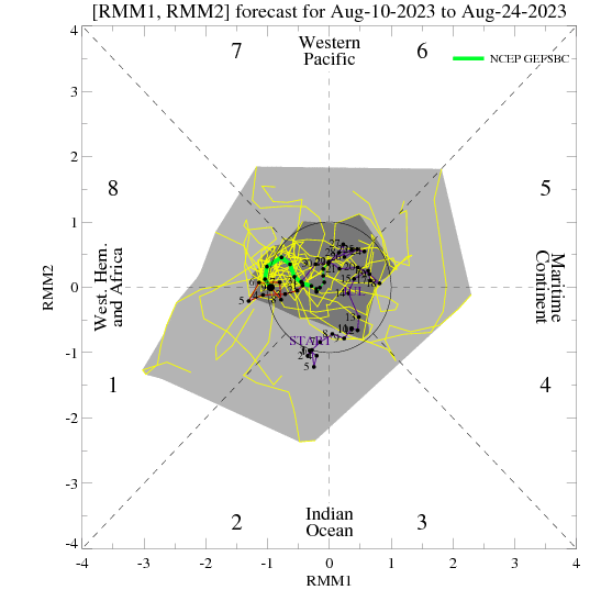
The MJO pop into the "Warm Phases" has really dampened the impact of the NE Pacific Warm Pool...need this to continue swinging into 7-8-1 to get things started favorably
1 likes
Who is online
Users browsing this forum: Sambucol2024, SnowyOwl31 and 35 guests