Texas Winter 2017-2018

Winter Weather Discussion

Moderator: S2k Moderators

Forum rules

The posts in this forum are NOT official forecast and should not be used as such. They are just the opinion of the poster and may or may not be backed by sound meteorological data. They are NOT endorsed by any professional institution or STORM2K.

Help Support Storm2K
Message
Author
User avatar
ThunderSleetDreams
S2K Supporter
S2K Supporter
Posts: 1398
Age: 42
Joined: Tue Dec 20, 2011 4:42 pm
Location: S of Weimar, TX

Re: Texas Winter 2017-2018

#1721 Postby ThunderSleetDreams » Fri Dec 15, 2017 8:58 am

Cheyenne ridge wrote:
ThunderSleetDreams wrote:
Yukon Cornelius wrote:Picked up another freeze. With a forecasted low of 32, it dropped to 28 with a light frost.


You live in the absolute best part of Texas for Winter lovers. If all goes as planned for me in the next 12-18 months, i will be living in Bozeman, MT and can be you guys satellite bellwether for Arctic fronts.

Houston has afforded me a lot of opportunity, but I’m ready to leave.
Great town to live in.When I left Houston in the fall of 2011,I lived in Belgrade for a year and enjoyed it before moving back home to Cheyenne.


Fell in love with Bozeman last year while visiting. I've been campaigning within my company to carve out a territory of Northern Idaho/Montana/Northern Wyoming and the Western Dakotas and we are making progress.

By the way, I got to experience my first Cheyenne Frontier Days a few years back. Good times and reminds me of a smaller HLSR, although a bit more authentic given the small town feel.
1 likes   
#NeverSummer

I hibernate when it gets above 75 degrees!

Ntxw
Storm2k Moderator
Storm2k Moderator
Posts: 21565
Joined: Wed Oct 21, 2009 6:34 pm
Location: DFW, Texas

Re: Texas Winter 2017-2018

#1722 Postby Ntxw » Fri Dec 15, 2017 9:08 am

orangeblood wrote:If you our a winter weather enthusiast residing in the southern plains, I don't think you can ask for a much better looking synoptic setup than what the Euro ENS Mean depicts for next weekend...numerous members on both the Euro and GFS ENS showing a very potent winter storm impacting Texas next weekend. As has been repeated numerous times, still way too early to know exact details (or that a storm is certain) but I don't believe you can have a better forecast map (if you're looking for a southern plains winter storm) from King Euro at this point.
https://www.tropicaltidbits.com/analysi ... amer_9.png


I've seen enough to persuade me something significant is about to happen. For once, everything else (besides the surface map of a model run) gives me more confidence that I'm just set on a pattern and waiting for the numerical global guidance to go to it. The slight shifts doesn't bother me much, if you know the model biases then you know how to correct it.

And really the domino isn't falling in 10 days, we are now nearing 5-7 days when the cold air begins to move. Front is coming next Thursday evening. There will likely be several waves of wintry precipitation.
4 likes   
The above post and any post by Ntxw is NOT an official forecast and should not be used as such. It is just the opinion of the poster and may or may not be backed by sound meteorological data. It is NOT endorsed by any professional institution including Storm2k. For official information, please refer to NWS products.

  Help support Storm2K!
Help Support Storm2K

User avatar
CaptinCrunch
S2K Supporter
S2K Supporter
Posts: 8580
Age: 56
Joined: Mon Nov 03, 2003 4:33 pm
Location: Lake Worth, TX (Tarrant Co.)

Re: Texas Winter 2017-2018

#1723 Postby CaptinCrunch » Fri Dec 15, 2017 9:09 am

When it comes to these major arctic fronts, Models most of the time are slower then the actual movement, and a lot of the times the dense cold air at the surface is ahead of the models by several hours. So if the GFS or EURO is showing the front here by noon on the 23rd, we may actually see the surface cold before sunrise. I'm hoping for the cold is here by the 22nd and what if any precip comes in on the 23rd..... :ggreen:
1 likes   

weatherdude1108
Category 5
Category 5
Posts: 4176
Joined: Tue Dec 13, 2011 1:04 pm
Location: Northwest Austin/Cedar Park, TX

Re: Texas Winter 2017-2018

#1724 Postby weatherdude1108 » Fri Dec 15, 2017 9:18 am

This is yesterday's blog by Bob Rose, so probably slightly outdated, but similar forecasts. :cold: :froze: :wink:

Longer-range forecast solutions call for a change in the weather pattern taking place next Friday, continuing through next weekend as a broad trough of low pressure in the upper atmosphere develops over central Canada and the Plains states. At the same time, a large ridge of high pressure just off the West Coast is forecast to build well north into western Canada. This "ridge/trough" configuration will allow very cold Polar air from northern Canada to spread south through the Rockies and into Texas. The leading edge of this colder air is forecast to push south across Texas next Friday. High temperatures are expected to fall to the upper 40s to low 50s next Friday and next weekend. Low temperatures are forecast to fall to the upper 30s. There are some indications a push of even colder air will arrive sometime around Christmas Eve.

Wet conditions are forecast to develop behind the cold front Friday and next weekend as an overrunning pattern takes shape. Periods of light are expected.

With rain expected and temperatures forecast to trend cold, we might see an opportunity for the development of some wintery precipitation sometime around Christmas Eve or Christmas Day. As of now, there is considerable uncertainty in just how cold temperatures will fall. This period of concern is just too far out to know any specifics at this time. We should know more over the coming days as forecast solutions get a better handle on developments.

Bob


https://www.lcra.org/water/river-and-we ... ather.aspx
1 likes   
The preceding post is NOT an official forecast, and should not be used as such. It is only the opinion of the poster and may or may not be backed by sound meteorological data. It is NOT endorsed by any professional institution including storm2k.org. For Official Information please refer to the NHC and NWS products.

orangeblood
S2K Supporter
S2K Supporter
Posts: 3334
Joined: Tue Dec 15, 2009 6:14 pm
Location: Fort Worth, TX

Re: Texas Winter 2017-2018

#1725 Postby orangeblood » Fri Dec 15, 2017 9:25 am

Ntxw wrote:
orangeblood wrote:If you our a winter weather enthusiast residing in the southern plains, I don't think you can ask for a much better looking synoptic setup than what the Euro ENS Mean depicts for next weekend...numerous members on both the Euro and GFS ENS showing a very potent winter storm impacting Texas next weekend. As has been repeated numerous times, still way too early to know exact details (or that a storm is certain) but I don't believe you can have a better forecast map (if you're looking for a southern plains winter storm) from King Euro at this point.
https://www.tropicaltidbits.com/analysi ... amer_9.png


I've seen enough to persuade me something significant is about to happen. For once, everything else (besides the surface map of a model run) gives me more confidence that I'm just set on a pattern and waiting for the numerical global guidance to go to it. The slight shifts doesn't bother me much, if you know the model biases then you know how to correct it.

And really the domino isn't falling in 10 days, we are now nearing 5-7 days when the cold air begins to move. Front is coming next Thursday evening. There will likely be several waves of wintry precipitation.


I'm not quite there yet but after following these winter patterns and models over the past decade, the variables you look for are coming together...IMO, probabilities have now increased to at least 50% chance for a significant storm. Although, the FTW NWS office doesn't quite agree with our assessment at this time :wink:

Curious how they came up with these probabilities because both the GFS and Euro Ensemble members are much greater than these, they must be putting a lot of weight in the operationals of both

Image
0 likes   

Yukon Cornelius
S2K Supporter
S2K Supporter
Posts: 1738
Age: 40
Joined: Thu Dec 20, 2012 9:23 pm
Location: Dean, TX/Westcliffe, CO

Re: Texas Winter 2017-2018

#1726 Postby Yukon Cornelius » Fri Dec 15, 2017 9:29 am

I always get a kick out of these 15 day long range forecasts from Accuweather and The Weather Channel. With every model run the forecast drastically changes. At that point, why even do a long range forecast when most of the time even a 5 day forecast is questionable?
1 likes   
#neversummer

User avatar
wxman57
Moderator-Pro Met
Moderator-Pro Met
Posts: 22512
Age: 66
Joined: Sat Jun 21, 2003 8:06 pm
Location: Houston, TX (southwest)

Re: Texas Winter 2017-2018

#1727 Postby wxman57 » Fri Dec 15, 2017 9:30 am

This potential winter weather event looks more terrifying than exciting. Going weeks without power and unable to travel anywhere doesn't sound like fun, to me. What's most troubling is that every GFS run indicates a significant warm nose aloft and only a very shallow surface freezing layer. That means freezing rain and sleet, not snow. It's the potential amount of freezing rain that is scary. I've lived in Texas since 1977 and I haven't seen anything like what the GFS is predicting.

Remember what I pointed out last week about the rule of thumb as to when a West Gulf Low forms? When the 500mb vorticity reaches El Paso, the low forms off the lower to mid TX coast. Once the low forms, the precipitation intensifies over Texas. Of course, there has to be a cold front out in the Gulf first, which will be the case next weekend. The GFS has the FIRST upper low/vort max reaching El Paso on Saturday, followed by at least 2 more. That means at least 3 precipitation events. With each event (in the wake of each low), more cold air will be drawn southward, pushing the sub-freezing air and freezing rain south.

What are the chances of the GFS being right? The Euro has temps above freezing through 240 hrs across Texas. Unfortunately, the Euro was way too "warm" with the snow event last week. I don't think it will handle the Arctic air well. On the bright side, there's not much snow cover to our north, so the Arctic air will modify considerably on its way south. Perhaps the surface temps will only be in the low 30s across central Texas and will remain above freezing across SE TX. I think that actually may be the most likely, but the potential for a massive ice storm is very scary.

This potential event is still 8 days away. I wouldn't panic yet. However, if the GFS is still going for it by Mon/Tue and the Euro's temps drop, then I may be treating it like a hurricane landfall. I'll fill up my 5-gal gas cans and make sure my generator is ready to go.

Image

Image

Image
6 likes   

Lagreeneyes03
Category 1
Category 1
Posts: 477
Joined: Mon Dec 09, 2013 10:53 am
Location: Luxurious Lake Grapevine

Re: Texas Winter 2017-2018

#1728 Postby Lagreeneyes03 » Fri Dec 15, 2017 9:34 am

Boy FTW really knows how to burst the hope of precipitation bubble for the Metroplex. Steve McCauley, however, is giving at least a 40% chance of hope to most of us. Said he would run his stat method in the next day or so.
0 likes   
I'm a Princess, not a forecaster.

orangeblood
S2K Supporter
S2K Supporter
Posts: 3334
Joined: Tue Dec 15, 2009 6:14 pm
Location: Fort Worth, TX

Re: Texas Winter 2017-2018

#1729 Postby orangeblood » Fri Dec 15, 2017 9:37 am

Long Range Discussion out of the WPC in Maryland - looks like they are leaning towards the Euro Ensembles as well....
------
EXTENDED FORECAST DISCUSSION
NWS WEATHER PREDICTION CENTER COLLEGE PARK MD
200 AM EST FRI DEC 15 2017

VALID 12Z MON DEC 18 2017 - 12Z FRI DEC 22 2017

...OVERVIEW AND GUIDANCE/PREDICTABILITY ASSESSMENT...


SHORTWAVE ENERGY SPLITS OVER THE WRN US TO CARVE OUT A WET SWRN US
MID-UPPER LEVEL TROUGH INTO MON THAT SHEARS PROGRRESSIVELY OUT
ACROSS THE US SRN TIER STATES EARLY-MID NEXT WEEK. MEANWHILE...A
SERIES OF NRN STREAM SYSTEMS PROGRESS OVERTOP THROUGH THE CENTRAL
AND ERN US NRN TIER STATES. THE 00 UTC GFS AND 12/00 UTC ECMWF
HAVE CONVERGED ON THEIR SOLUTIONS FOR THIS TIME
PERIOD...BOLSTERING FORECAST CONFIDENCE BACK TO AVERAGE
LEVELS...ALBEIT WITH SOME PESKY CONTINUED EMBEDDED SYSTEM TIMING
VARIANCES. A BLEND OF THE 00 UTC GFS/ECMWF AND PERHAPS A BIT OF
SMOOTHING ENSEMBLES SEEMS REASONABLE.

FORECAST SPREAD AND UNCERTAINTY INCREASE MID-LATER NEXT WEEK AS
GUIDANCE STRUGGLES WITH THE EXTENT/DETAILS OF ADDITIONAL POTENT
SHORTWAVE TROUGH ENERGY DIGGING FROM THE ERN PACIFIC DOWN THROUGH
THE WRN STATES IN RESPONSE TO SHARP UPSTREAM MID-UPPER RIDGE
AMPLIFICATION. THE 00 UTC GFS HAS ABANDONED THE DEVELOPMENT OF A
SWRN US CLOSED LOW LATE NEXT WEEK CHAMPIONED BY EARLY GFS RUNS.
HOWEVER...SUPPORTING TROUGH DIGGING THROUGH THE WEST COAST INTO
THE SWRN US MAY STILL BE AMPLE SO USED THE MOST AMPLIFIED OF THE
ENSEMBLE MEANS...THE ECMWF ENSEMBLES...INTO DAY 6/7 GIVEN UPSTREAM
SUPPORT FROM SUCH A AMPLIFIED UPSTREAM RIDGE ALOFT OVER THE
PACIFIC. THIS ENERGY IS THEN INJECTED INTO/UNDERNEATH A BROAD
LONGWAVE THROUGH OVER THE CENTRAL TO ERN US.


...WEATHER HIGHLIGHTS/THREATS...


IT REMAINS THE CASE THAT THE GULF COAST/SRN TIER STATES WILL
REMAIN AN AREA OF INTEREST FOR HEAVY RAINFALL POTENTIAL WITH
EJECTING W-CENTRAL U.S. SHORTWAVE ENERGY/ASSOCIATED COLD FRONT AS
WELL AS A POSSIBLE LEADING STATIONARY BOUNDARY PROVIDING FOCUS FOR
THIS ACTIVITY. BEST POTENTIAL FOR HIGHEST RAINFALL TOTALS APPEARS
TO BE SUN-TUE...THEN OUT ACROSS THE ERN STATES. MEANWHILE...THE
APPROACH/ARRIVAL OF THE NORTHEAST PACIFIC UPPER TROUGH WILL LIKELY
BRING A PERIOD OF MEANINGFUL RAIN/HIGHER ELEVATION SHOW TO FAVORED
TERRAIN OF THE PACIFIC NORTHWEST AND NRN ROCKIES. PRECIP SHOULD BE
CONFINED TO FAR NRN AREAS EARLY NEXT WEEK AND THEN PUSH SOUTHWARD
MID-LATER WEEK WITH SOME MOISTURE WORKING MORE INTO CA. THE
POTENTIAL FOR THE COMBINATION OF SNOW AND WIND WILL HAVE TO BE
MONITORED OVER PARTS OF THE ROCKIES/PLAINS AS LOW PRESSURE EMERGES
INTO THE CENTRAL U.S. LATER WEEK. OVER THE EAST...MOST SNOW SHOULD
BE CONFINED TO NRN TIER LOCATIONS WITH A COMBINATION OF
SYNOPTIC/LOW PASSAGE AND LAKE EFFECT ACTIVITY.
0 likes   

Theepicman116
Tropical Depression
Tropical Depression
Posts: 95
Age: 25
Joined: Sat Nov 26, 2016 10:43 pm
Location: Stephenville

Re: Texas Winter 2017-2018

#1730 Postby Theepicman116 » Fri Dec 15, 2017 9:49 am

Image

I would like to take a raincheck on that freezing rain. Please and thank you. Maybe bring it back...never? Never sounds good to me. :ggreen:
0 likes   

Ralph's Weather
S2K Supporter
S2K Supporter
Posts: 2969
Age: 37
Joined: Fri Dec 13, 2013 11:55 am
Location: Lindale, TX

Re: Texas Winter 2017-2018

#1731 Postby Ralph's Weather » Fri Dec 15, 2017 9:51 am

orangeblood wrote:I'm not quite there yet but after following these winter patterns and models over the past decade, the variables you look for are coming together...IMO, probabilities have now increased to at least 50% chance for a significant storm. Although, the FTW NWS office doesn't quite agree with our assessment at this time :wink:

Curious how they came up with these probabilities because both the GFS and Euro Ensemble members are much greater than these, they must be putting a lot of weight in the operationals of both

http://www.weather.gov/images/fwd/graph ... 9e5f19fab5

I thought that that chart was pretty ridiculous myself. I understand not wanting to hype, but it is also important to allow people a chance to prep. This situation is not dissimilar to that of a hurricane being modeled to hit Texas within a week, you have to acknowledge that the threat is real even if not guaranteed.
3 likes   
Follow on Facebook at Ralph's Weather.

User avatar
spencer817
Tropical Storm
Tropical Storm
Posts: 197
Age: 25
Joined: Thu Nov 17, 2016 3:22 pm
Location: Coppell, TX

Re: Texas Winter 2017-2018

#1732 Postby spencer817 » Fri Dec 15, 2017 9:53 am

Ralph's Weather wrote:
orangeblood wrote:I'm not quite there yet but after following these winter patterns and models over the past decade, the variables you look for are coming together...IMO, probabilities have now increased to at least 50% chance for a significant storm. Although, the FTW NWS office doesn't quite agree with our assessment at this time :wink:

Curious how they came up with these probabilities because both the GFS and Euro Ensemble members are much greater than these, they must be putting a lot of weight in the operationals of both

http://www.weather.gov/images/fwd/graph ... 9e5f19fab5

I thought that that chart was pretty ridiculous myself. I understand not wanting to hype, but it is also important to allow people a chance to prep. This situation is not dissimilar to that of a hurricane being modeled to hit Texas within a week, you have to acknowledge that the threat is real even if not guaranteed.

I totally agree, I dont feel like the chances are THAT high that we see dry weather. If you show a chart like that, people will blow it off.
2 likes   
I'm going to go to school for this stuff :P

User avatar
CaptinCrunch
S2K Supporter
S2K Supporter
Posts: 8580
Age: 56
Joined: Mon Nov 03, 2003 4:33 pm
Location: Lake Worth, TX (Tarrant Co.)

Re: Texas Winter 2017-2018

#1733 Postby CaptinCrunch » Fri Dec 15, 2017 10:04 am

The weather office here in FTW is not going to say anything regarding the next weekend system till it's next weekend. They most likely will have to play catchup to the models as they become more likely a winter wx event will happen. This is Texas and it's been a LONG time since we seen a ice storm, and if you look back to the 2013 snow event we had they never got ahead of the event that dropped 12" of snow average across DFW. Even the Cobblestone ice event across DFW was a bust forecast for them as we got 1" of ice and 5" of sleet when they were forecasting lite accumulations.
Last edited by CaptinCrunch on Fri Dec 15, 2017 10:08 am, edited 1 time in total.
3 likes   

User avatar
bubba hotep
S2K Supporter
S2K Supporter
Posts: 5610
Joined: Wed Dec 28, 2016 1:00 am
Location: Collin County Texas

Re: Texas Winter 2017-2018

#1734 Postby bubba hotep » Fri Dec 15, 2017 10:05 am

Over the next few days we will be moving into the range that the models have been dropping the cutoff solutions and trending back towards the low frequency background state. They keep wanting to shakeup the pattern beyond D8 - 10 but keep failing to bring that forward. We have seen 2 or 3 solid longer range events at DFW (2"+ precipitation) with considerable ensemble support fall apart as we start approaching D7.
0 likes   
Winter time post are almost exclusively focused on the DFW area.

Ntxw
Storm2k Moderator
Storm2k Moderator
Posts: 21565
Joined: Wed Oct 21, 2009 6:34 pm
Location: DFW, Texas

Re: Texas Winter 2017-2018

#1735 Postby Ntxw » Fri Dec 15, 2017 10:09 am

SOI is negative -12 daily and has seen several days of negatives. And that's against a Nina background state. Got a feeling qpf won't be a problem down the road.
2 likes   
The above post and any post by Ntxw is NOT an official forecast and should not be used as such. It is just the opinion of the poster and may or may not be backed by sound meteorological data. It is NOT endorsed by any professional institution including Storm2k. For official information, please refer to NWS products.


  Help support Storm2K!

Help Support Storm2K


orangeblood
S2K Supporter
S2K Supporter
Posts: 3334
Joined: Tue Dec 15, 2009 6:14 pm
Location: Fort Worth, TX

Re: Texas Winter 2017-2018

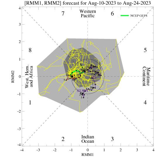
#1736 Postby orangeblood » Fri Dec 15, 2017 10:19 am

bubba hotep wrote:Over the next few days we will be moving into the range that the models have been dropping the cutoff solutions and trending back towards the low frequency background state. They keep wanting to shakeup the pattern beyond D8 - 10 but keep failing to bring that forward. We have seen 2 or 3 solid longer range events at DFW (2"+ precipitation) with considerable ensemble support fall apart as we start approaching D7.


According to the MJO forecast, the shakeup could be occurring this time around....

Image
0 likes   

weatherdude1108
Category 5
Category 5
Posts: 4176
Joined: Tue Dec 13, 2011 1:04 pm
Location: Northwest Austin/Cedar Park, TX

Re: Texas Winter 2017-2018

#1737 Postby weatherdude1108 » Fri Dec 15, 2017 10:20 am

According to the 6Z GFS, the Austin vicinity will have roughly 66 consecutive hours of freezing and below temperatures from Christmas Eve through December 28th, with freezing precipitation of some sort nearly the whole day Christmas Eve. It puts down roughly six inches of snow along the I35 corridor. I'll just put that one image since it doesn't take up as much space as multiple maps at one time. :P
This would give the northern half of Texas a white Christmas morning! :froze: :)

I'm...dreaming...of a white........Christmas....


Image
0 likes   
The preceding post is NOT an official forecast, and should not be used as such. It is only the opinion of the poster and may or may not be backed by sound meteorological data. It is NOT endorsed by any professional institution including storm2k.org. For Official Information please refer to the NHC and NWS products.

User avatar
bubba hotep
S2K Supporter
S2K Supporter
Posts: 5610
Joined: Wed Dec 28, 2016 1:00 am
Location: Collin County Texas

Re: Texas Winter 2017-2018

#1738 Postby bubba hotep » Fri Dec 15, 2017 10:21 am

00z Euro EPS has trended slightly cooler with each run for Christmas period. The run last night had about 8 freezes in a row at DFW with highs below 50 (it seems to have a warm bias in the long range) with a mean of 0.75" of precipitation falling during that period.
1 likes   
Winter time post are almost exclusively focused on the DFW area.

Lagreeneyes03
Category 1
Category 1
Posts: 477
Joined: Mon Dec 09, 2013 10:53 am
Location: Luxurious Lake Grapevine

Re: Texas Winter 2017-2018

#1739 Postby Lagreeneyes03 » Fri Dec 15, 2017 10:28 am

spencer817 wrote:
Ralph's Weather wrote:
orangeblood wrote:I'm not quite there yet but after following these winter patterns and models over the past decade, the variables you look for are coming together...IMO, probabilities have now increased to at least 50% chance for a significant storm. Although, the FTW NWS office doesn't quite agree with our assessment at this time :wink:

Curious how they came up with these probabilities because both the GFS and Euro Ensemble members are much greater than these, they must be putting a lot of weight in the operationals of both

http://www.weather.gov/images/fwd/graph ... 9e5f19fab5

I thought that that chart was pretty ridiculous myself. I understand not wanting to hype, but it is also important to allow people a chance to prep. This situation is not dissimilar to that of a hurricane being modeled to hit Texas within a week, you have to acknowledge that the threat is real even if not guaranteed.

I totally agree, I dont feel like the chances are THAT high that we see dry weather. If you show a chart like that, people will blow it off.


Honestly, we started prepping yesterday. Got 5 24 packs of bottled water, extra cokes, juice, etc to put away "just in case". We are visit the grocery store 1-2x a week people so just getting some extra things before the mad rush next weekend. Will be adding to the small stockpile this week, making sure any daily supplements/medications are in order, enough snacks and wine/beer and getting firewood. Making sure aux batteries for cell phone are charged. I'd even thought of getting a generator recently, just because I've always felt it's something we should have here with the severe weather and all, and a plan to move to the west coast of FL in about 2 years. Now's a good a time as any maybe.
3 likes   
I'm a Princess, not a forecaster.

stormlover2013
Category 5
Category 5
Posts: 2312
Joined: Thu Aug 22, 2013 12:06 pm
Location: Lumberton, Texas

Re: Texas Winter 2017-2018

#1740 Postby stormlover2013 » Fri Dec 15, 2017 10:31 am

its fun modeling watching no doubt, but we still have 5 days till we really need to watch, these models flip flop just like during hurricane season.
0 likes   


Return to “Winter Weather”

Who is online

Users browsing this forum: No registered users and 16 guests