Southern Plains winter wx thread (2008-2009)
Moderator: S2k Moderators
Forum rules
 The posts in this forum are NOT official forecast and should not be used as such. They are just the opinion of the poster and may or may not be backed by sound meteorological data. They are NOT endorsed by any professional institution or STORM2K.
 The posts in this forum are NOT official forecast and should not be used as such. They are just the opinion of the poster and may or may not be backed by sound meteorological data. They are NOT endorsed by any professional institution or STORM2K.
- Extremeweatherguy
- Category 5

- Posts: 11095
- Joined: Mon Oct 10, 2005 8:13 pm
- Location: Florida
Re: Arctic blast to start December??? (Plains and East)
Something seems "off" about the 12z GFS.
It shows a 1040mb+ high pressure system building in NW Canada by hour 114 ( http://www.nco.ncep.noaa.gov/pmb/nwprod ... n_114l.gif ), but within 48 hours it completely kills the high and never allows it to move southward into the United States ( hour 162: http://www.nco.ncep.noaa.gov/pmb/nwprod ... n_162l.gif ). While this scenario is certainly possible, it just doesn't seem too realistic. I guess we will see what happens.
----------------------------------------------------------------------------------------------------------------------------------------
BTW - Joe Bastardi also thinks the GFS is way under-doing next week's cold. This morning the model was showing a high of 47F in Omaha, NE next Thursday, but Joe Bastardi thinks it will be 15-30 degrees colder than that. According to him, he thinks the ECMWF is doing a much better job with the incoming air mass, noting specifically that the projected 850mb temperatures on the Euro are 14 degrees colder over Omaha, NE than they are on the GFS for the same exact day.
0 likes
- Extremeweatherguy
- Category 5

- Posts: 11095
- Joined: Mon Oct 10, 2005 8:13 pm
- Location: Florida
The 12z ECMWF continues to look much colder than the GFS, and is showing a very chilly pattern for the plains and the east next week...
http://www.ecmwf.int/products/forecasts ... 12!!!step/
For OKC in particular: The ECMWF is showing 850mb temperatures dropping to near -5C and 1000-500mb thicknesses falling to 533 by late next week. At the same time, it also brings 700mb RHU up to 95% and 850mb RHU up to 55%, meaning that clouds and wintry precipitation could be possible in Oklahoma if the ECMWF scenario plays out.
0 likes
Re: ECMWF shows arctic front for next week (Plains and East)
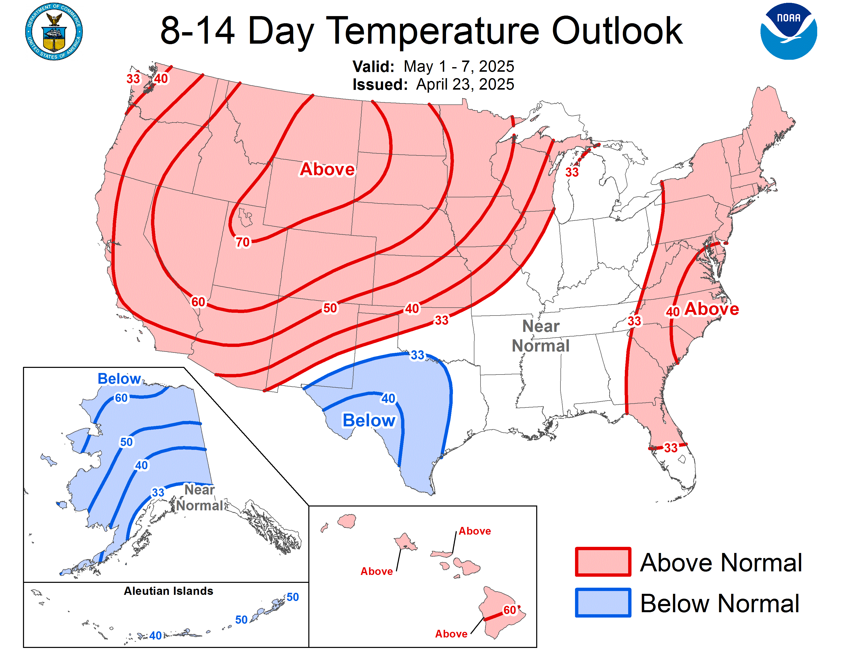
Here is a set-up we haven't seen in the forecast for a while...today's CPC 8-14 day temp outlook...


0 likes
Re: ECMWF shows arctic front for next week (Plains and East)
I don't know, I don't see this cold air in any forecast. Noaa's forecast looks normal to above normal. With highs in the 60's and 70's next week.
BOO.
BOO.
0 likes
- Extremeweatherguy
- Category 5

- Posts: 11095
- Joined: Mon Oct 10, 2005 8:13 pm
- Location: Florida
The 00z GFS continues to hold back on the cold for next week, showing only a glancing blow. The same cannot be said for the longer range though. Beyond hour 200, this is one of the coldest and wildest GFS runs I have seen in a long time. Multiple winter storms are depicted impacting the southern plains between December 8th and December 15th, dumping quite a bit of snow and ice over north Texas and Oklahoma.
0 likes
Re: ECMWF shows arctic front for next week (Plains and East)
Holy new gfs 00 looks very good 10 days out and beyond. But you know it'll change and will end up showing mild and dry.
Why do the computer models hate us?
Why do the computer models hate us?
0 likes
Re: ECMWF shows arctic front for next week (Plains and East)
Can't imagine a true 'arctic invasion' in the lower 48 with grass showing from parts of canada down through the u.s. from north to south...more of a snowpack (outside of Lake effect zones) needs to be established....still early in the season for that.


0 likes
Re: ECMWF shows arctic front for next week (Plains and East)
jinftl wrote:Can't imagine a true 'arctic invasion' in the lower 48 with grass showing from parts of canada down through the u.s. from north to south...more of a snowpack (outside of Lake effect zones) needs to be established....still early in the season for that.
Don't bring reality here, it's too depressing.
0 likes
Re: ECMWF shows arctic front for next week (Plains and East)
I am curious if models take into account current snowpack compared to normal for the time of year as one factor in producing forecast runs?
(sorry to throw some of the analysis behind the science into the model runs thread)
(sorry to throw some of the analysis behind the science into the model runs thread)
iorange55 wrote:jinftl wrote:Can't imagine a true 'arctic invasion' in the lower 48 with grass showing from parts of canada down through the u.s. from north to south...more of a snowpack (outside of Lake effect zones) needs to be established....still early in the season for that.
Don't bring reality here, it's too depressing.
0 likes
- Portastorm
- Storm2k Moderator

- Posts: 9954
- Age: 63
- Joined: Fri Jul 11, 2003 9:16 am
- Location: Round Rock, TX
- Contact:
Re: ECMWF shows arctic front for next week (Plains and East)
At 240 hours, both the 0z GFS and Euro don't really show any arctic intrusions. Beyond 240 hrs, the GFS does show a potent low and deep, cold trough sweeping through the nation's midsection, at least on the 0z run.
The Euro at 240 hrs, 500 mb flow:

The GFS at 240 hrs, 500 mb flow:

The Euro at 240 hrs, 500 mb flow:

The GFS at 240 hrs, 500 mb flow:

0 likes
- Extremeweatherguy
- Category 5

- Posts: 11095
- Joined: Mon Oct 10, 2005 8:13 pm
- Location: Florida
Re: ECMWF shows arctic front for next week (Plains and East)
The ECMWF continues to be much colder than the GFS for next week, showing a very chilly setup for the plains.
Loop of the 00z ECMWF: http://www.ecmwf.int/products/forecasts ... 00!!!step/
The biggest difference comes next Wednesday night into Thursday...
00z ECMWF: http://www.ecmwf.int/products/forecasts ... !chart.gif
00z GFS: http://www.nco.ncep.noaa.gov/pmb/nwprod ... 0_120l.gif
The GFS tries to shunt most of the cold air north and east, while the Euro brings the cold air right down the plains.
0 likes
Re: How cold will it get next week? GFS vs. EURO
CPC's Extended Outlook for temps...seems to show ridging setting up in the east and troughiness in the west...it's about time!!!
Below normal in the northern plains this time of year can be quite cold...be interesting to see what develops.

Below normal in the northern plains this time of year can be quite cold...be interesting to see what develops.

0 likes
- Extremeweatherguy
- Category 5

- Posts: 11095
- Joined: Mon Oct 10, 2005 8:13 pm
- Location: Florida
Re: How cold will it get next week? GFS vs. EURO
The 12z GFS is starting to look a little bit colder for next week. It definitely does not show an "arctic outbreak", and it is not as cold as the ECMWF, but it certainly looks cooler than what the 00z and 06z runs of the GFS depicted.
Here are a few select highlights from the latest run of the GFS...
The front quickly surges southward during the day Wednesday
morning - http://www.nco.ncep.noaa.gov/pmb/nwprod ... n_096l.gif
afternoon - http://www.nco.ncep.noaa.gov/pmb/nwprod ... n_102l.gif
evening - http://www.nco.ncep.noaa.gov/pmb/nwprod ... n_108l.gif
Freeze line reaches north Texas by Thursday morning
http://www.nco.ncep.noaa.gov/pmb/nwprod ... n_120l.gif
Chilly day on Thursday with high temperatures in the 30s and 40s across the southern plains (except 50s in south Texas)
http://www.nco.ncep.noaa.gov/pmb/nwprod ... n_126l.gif
0 likes
- Extremeweatherguy
- Category 5

- Posts: 11095
- Joined: Mon Oct 10, 2005 8:13 pm
- Location: Florida
Re: How cold will it get next week? GFS vs. EURO
Check out the 18z NAM! It is showing a very cold setup for next week with a 1052mb high forming in NW Canada while a low pressure system traverses southern Canada and another one traverses the plains. Beyond 84 hours, it is likely that the lows will pull the strong high southward sending temps falling fast across much of the country by the end of the week...
http://www.nco.ncep.noaa.gov/pmb/nwprod ... p_084l.gif
http://www.nco.ncep.noaa.gov/pmb/nwprod ... 0_084l.gif
http://www.nco.ncep.noaa.gov/pmb/nwprod ... p_084l.gif
http://www.nco.ncep.noaa.gov/pmb/nwprod ... 0_084l.gif
0 likes
-
Ed Mahmoud
Re:
iorange55 wrote:The GFS is weird, it always seems like it takes the cold air east, every single time.
PPV AccuWx shows -30ºC airmass gettimg ready to cross the border in 15 days, and the snowpack down South to almost Kansas City.
ETA: The Winter equivalent of the GFS showing a Cat 3 in the Bahamas in 15 days headed in the general direction of the US...
0 likes
Re: Re:
You know, every rainshower in Dakar is a potential Cat 5 staring at Miami two weeks later...or at least there will usually be, as Ed says, a model run showing that.
If we can actually get a snowpack outside of the Lake Effect zones and higher mountain areas...something that hasn't happened yet this season with any staying-power...then, i would begin to pay more attention to the models showing ice-skating on galveston bay and lake ponchairtrain...and only then, with a grain of salt.
Heck, in 10 or 12 weeks we will be talking spring....extreme winter weather, esp south of the mason dixon, has a much smaller 'window of opportunity' than, say, the 6 months of hurricane season or 90+ weather in parts of Texas and Florida.
Ed Mahmoud wrote:iorange55 wrote:The GFS is weird, it always seems like it takes the cold air east, every single time.
PPV AccuWx shows -30ºC airmass gettimg ready to cross the border in 15 days, and the snowpack down South to almost Kansas City.
ETA: The Winter equivalent of the GFS showing a Cat 3 in the Bahamas in 15 days headed in the general direction of the US...
0 likes
- Extremeweatherguy
- Category 5

- Posts: 11095
- Joined: Mon Oct 10, 2005 8:13 pm
- Location: Florida
- Extremeweatherguy
- Category 5

- Posts: 11095
- Joined: Mon Oct 10, 2005 8:13 pm
- Location: Florida
Well this is interesting...
Looks like the Norman, OK NWS is now thinking that some snow showers will be possible this afternoon and evening. Hopefully I manage to see some flakes!
SHORT TERM FORECAST
NATIONAL WEATHER SERVICE NORMAN OK
1235 PM CST SUN NOV 30 2008
OKZ004>048-050>052-TXZ083>090-302000-
ALFALFA-ARCHER-ATOKA-BAYLOR-BECKHAM-BLAINE-BRYAN-CADDO-CANADIAN-
CARTER-CLAY-CLEVELAND-COAL-COMANCHE-COTTON-CUSTER-DEWEY-ELLIS-FOARD-
GARFIELD-GARVIN-GRADY-GRANT-GREER-HARDEMAN-HARMON-HARPER-HUGHES-
JACKSON-JEFFERSON-JOHNSTON-KAY-KINGFISHER-KIOWA-KNOX-LINCOLN-LOGAN-
LOVE-MAJOR-MARSHALL-MCCLAIN-MURRAY-NOBLE-OKLAHOMA-PAYNE-PONTOTOC-
POTTAWATOMIE-ROGER MILLS-SEMINOLE-STEPHENS-TILLMAN-WASHITA-WICHITA-
1235 PM CST SUN NOV 30 2008
.NOW...
...REGIONAL WEATHER DISCUSSION...
NORTHWEST WINDS AT 25 TO 35 MPH... WITH GUSTS NEAR 50 MPH WILL
CONTINUE THROUGH THE AFTERNOON ACROSS MOST OF THE WESTERN TWO THIRDS
OF OKLAHOMA... AND WESTERN NORTH TEXAS. THIS WILL RESULT IN WIND
CHILL VALUES IN THE MID TO UPPER 30S ACROSS THE NORTHERN HALF OF
OKLAHOMA.
IN ADDITION... A FEW SCATTERED LIGHT RAIN AND SNOW SHOWERS CAN BE
EXPECTED ACROSS OKLAHOMA AND NORTH TEXAS THROUGH THE EARLY EVENING.
NO SIGNIFICANT RAINFALL OR SNOWFALL IS EXPECTED. ANY SNOW THAT
FALLS WILL MELT QUICKLY DUE TO RELATIVELY WARM GROUND TEMPERATURES.
This Afternoon: A slight chance of rain and snow showers. Mostly cloudy, with a high near 48. Windy, with a north northwest wind between 15 and 25 mph, with gusts as high as 36 mph. Chance of precipitation is 20%.
Looks like the Norman, OK NWS is now thinking that some snow showers will be possible this afternoon and evening. Hopefully I manage to see some flakes!
0 likes
- MGC
- S2K Supporter

- Posts: 5940
- Joined: Sun Mar 23, 2003 9:05 pm
- Location: Pass Christian MS, or what is left.
Re: How cold will it get next week? GFS vs. EURO
By mid December it is possible for snow on the Mississippi Coast. It happened on 18 Dec 1996 when both Biloxi and Gulfport reported 1 inch. Mobile airport reported over 3 inches from that storm. Read all about it here: http://www.srh.noaa.gov/mob/121896Snow/18Dec96main.html
0 likes

