iam prepared to say out on a limb knowing it COULD be wrong BUT i can say this with
a good bit of confidence this COMING WEEKEND IS GOING TO BE COLD IN OK AND TX
and the highs you see on your local forecast wherever you are in the ok/tx region are
to high and will be coming down. anyone who doesn't believe me just look at the latest
00z nam run.. it only goes out 84 hrs for you that dont know the models that well but
just look at the last couple frames i dont see nothing holding that cold air back, we
could have true arctic air into northern tx even by i would say late sat into sunday..
this could even be historic and be around awhile, iam staying up for the 00z gfs now
see if there is any signs of change on it.
EDIT: surface temps down to around -13 nrn kansas by 6 am friday morning now if that isnt
arctic air i dont know what is lol for getting this far south! i expect local media, nws
to hit this hard in the coming 24-48 hours if these signs stay there b/c this could be a
VERY significant outbreak of cold air that *COULD* being as cold as it is be around for
a good week or two and create some real problems for the southern plains region.
Southern Plains winter wx thread (2009-2010)
Moderator: S2k Moderators
Forum rules
 The posts in this forum are NOT official forecast and should not be used as such. They are just the opinion of the poster and may or may not be backed by sound meteorological data. They are NOT endorsed by any professional institution or STORM2K.

The posts in this forum are NOT official forecast and should not be used as such. They are just the opinion of the poster and may or may not be backed by sound meteorological data. They are NOT endorsed by any professional institution or STORM2K.
-
cheezyWXguy

- Category 5

- Posts: 6280
- Joined: Mon Feb 13, 2006 12:29 am
- Location: Dallas, TX
Re:
msstateguy83 wrote:iam prepared to say out on a limb knowing it COULD be wrong BUT i can say this with
a good bit of confidence this COMING WEEKEND IS GOING TO BE COLD IN OK AND TX
and the highs you see on your local forecast wherever you are in the ok/tx region are
to high and will be coming down. anyone who doesn't believe me just look at the latest
00z nam run.. it only goes out 84 hrs for you that dont know the models that well but
just look at the last couple frames i dont see nothing holding that cold air back, we
could have true arctic air into northern tx even by i would say late sat into sunday..
this could even be historic and be around awhile, iam staying up for the 00z gfs now
see if there is any signs of change on it.
EDIT: surface temps down to around -13 nrn kansas by 6 am friday morning now if that isnt
arctic air i dont know what is lol for getting this far south! i expect local media, nws
to hit this hard in the coming 24-48 hours if these signs stay there b/c this could be a
VERY significant outbreak of cold air that *COULD* being as cold as it is be around for
a good week or two and create some real problems for the southern plains region.
Those are some pretty bold predictions but I gotta say, if youre right I will love you. No homo
0 likes
-
msstateguy83
LOL i hear ya i think alot of ppl will love it =) there is just some things you look at to me
that is just common sence we are almost 8 days in dec, in a year we know is going to be per our pattern we are getting into a more active winter then usual for the southern plains take that with what the models are hinting at i just cant help myself from thinking its going to dip all the way down this far south. i just dont buy the hanging up or going away that the models have been doing and as someone posted earlyer they have been gradually going further and further south every run with the arctic air. i agree its pretty BOLD prediction, statement but the way i look @ things say what you think, air on the side of caution v.s. waiting till the last minute and in my eyes this is a serrious threat as far as the arctic air coming our way for the weekend, yes there is always that chance it could 'bust' but this is the most impressive setup i've seen in quite sometime.
that is just common sence we are almost 8 days in dec, in a year we know is going to be per our pattern we are getting into a more active winter then usual for the southern plains take that with what the models are hinting at i just cant help myself from thinking its going to dip all the way down this far south. i just dont buy the hanging up or going away that the models have been doing and as someone posted earlyer they have been gradually going further and further south every run with the arctic air. i agree its pretty BOLD prediction, statement but the way i look @ things say what you think, air on the side of caution v.s. waiting till the last minute and in my eyes this is a serrious threat as far as the arctic air coming our way for the weekend, yes there is always that chance it could 'bust' but this is the most impressive setup i've seen in quite sometime.
Last edited by msstateguy83 on Mon Dec 07, 2009 11:08 pm, edited 1 time in total.
0 likes

Re: Southern Plains winter wx thread (2009-2010)
This past week or so has been quite chilly as it is for a long period of time. It's been awhile since i've recalled such a period with below average numbers without a briefly warming up a day or two this early in the season lacking much snow cover at the time might I add.
0 likes
The above post and any post by Ntxw is NOT an official forecast and should not be used as such. It is just the opinion of the poster and may or may not be backed by sound meteorological data. It is NOT endorsed by any professional institution including Storm2k. For official information, please refer to NWS products.
Help support Storm2K!
-
msstateguy83
Re: Southern Plains winter wx thread (2009-2010)
per the gfs again from what i can see so far appears it showing the cold air hanging up in kansas
still, just disappearing hard for me to believe THAT COLD of air just goes away that quickly, i mean
strange things have happened in meteorology but lol this one i still do not buy into i believe it will
make it into a large portion of oklahoma and parts of n.tx but we shall see... considering how cold
today was, if i remember correctly gfs over did todays temps several days ago for today so i mean
i take the gfs with a grain of salt for the time being b/c that is very very COLD arctic air by thu-fri
into srn ks, you cant tell me 24 hours later it pretty much disappears.. but who knows time will tell...
edit: if this gfs run is to be believed it shows the temp near wichita falls @ near 60 at noon on sunday
0 likes
-
Extremeweatherguy

- Category 5
- Posts: 11095
- Joined: Mon Oct 10, 2005 8:13 pm
- Location: Florida
-
Extremeweatherguy
- Category 5
- Posts: 11095
- Joined: Mon Oct 10, 2005 8:13 pm
- Location: Florida

Re: Southern Plains winter wx thread (2009-2010)
For some reason I just don't think the arctic air will make it down here next week I'd think it'd show stronger on the models by now. Not exactly coming down all the way, but even to our north I'd think it'd look a little more impressive, but maybe it's just so strong they're just not handling it well at all, which is what i'm hoping for.
0 likes
-
msstateguy83
iorange55 i see that point to and guys dont get me wrong iam by no means betting the house, ranch, bank acct and all on this LOL it really could go either way just seeing that COLD of temps into central,srn ks by fri am to me its hard to believe it just hangsup,disappears there but in the coming days we should have this all figured out one way or another. =)
0 likes
-
Extremeweatherguy
- Category 5
- Posts: 11095
- Joined: Mon Oct 10, 2005 8:13 pm
- Location: Florida
Re: Southern Plains winter wx thread (2009-2010)
It is showing up much better on the ECMWF and the CMC, and actually the GFS is not all too bad right now. Yes, it fizzles it once it reaches us, but it does indeed show up nicely to our north. All three of these models show impressive sub -20C 850mb temperatures working into the northern USA by Sunday morning. Brr!iorange55 wrote:For some reason I just don't think the arctic air will make it down here next week I'd think it'd show stronger on the models by now. Not exactly coming down all the way, but even to our north I'd think it'd look a little more impressive, but maybe it's just so strong they're just not handling it well at all, which is what i'm hoping for.
12z ECMWF (144 hrs):

12z CMC (144 hrs):
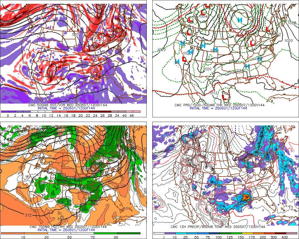
00z GFS (144 hrs):

I do agree though, after feeling let down with the current system (not getting the big OK/N TX winter storm once promised by the models), I am not going to buy into this arctic outbreak 100% until we are much closer to the event (a.k.a probably not until this Friday or so).
Last edited by Extremeweatherguy on Mon Dec 07, 2009 11:57 pm, edited 1 time in total.
0 likes
Well we are long overdue for a 1989 type december 
0 likes
The above post and any post by Ntxw is NOT an official forecast and should not be used as such. It is just the opinion of the poster and may or may not be backed by sound meteorological data. It is NOT endorsed by any professional institution including Storm2k. For official information, please refer to NWS products.
Help support Storm2K!
Help support Storm2K!
-
BlueIce
- S2K Supporter

- Posts: 194
- Age: 37
- Joined: Mon Sep 01, 2008 10:05 pm
- Location: Oklahoma City, Oklahoma
Re: Southern Plains winter wx thread (2009-2010)
I just walked the trash to the road and we are getting drizzle at my house, I dont think the temperature is below freezing here yet though. My weather station is reading 33 and the outdoor thermometer is reading 30. But we are getting close. This could be a rough commute in the OKC metro area in the morning.
0 likes
-
Extremeweatherguy
- Category 5
- Posts: 11095
- Joined: Mon Oct 10, 2005 8:13 pm
- Location: Florida
I just took a look at the 00z GFS and NAM MOS guidance, and regardless of what happens this weekend or next week, it looks like it will be getting very cold for Oklahoma City in the shorter term. The 00z GFS MOS is showing a low of 11F in OKC on Wednesday night, while the 00z NAM MOS is showing a low of 13F! Thursday morning will definitely be a frigid one if those numbers play out.

It also looks quite chilly for everyone down near Dallas too. The 00z GFS MOS is calling for a low of 25F on Wednesday night at DFW, while the 00z NAM MOS is calling for a low of 24F.
-------------------------------------------------------------------------
BTW: I am starting to get a little bit of freezing drizzle now on the south side of OKC.
0 likes
-
Extremeweatherguy
- Category 5
- Posts: 11095
- Joined: Mon Oct 10, 2005 8:13 pm
- Location: Florida
The 00z ECMWF continues to look much more aggressive than the GFS, and has the arctic airmass diving southward through Kansas by Sunday evening (144 hrs): http://www.meteo.psu.edu/ewall/ECMWF_0z/f144.gif
0 likes
Re: Southern Plains winter wx thread (2009-2010)
I had hopes for the GFS 06 at first, but then it continued to look unimpressive it looks impressive for about a day then it just fizzles out. I don't really get it. It shows it building, where is it going? Hm.
grrrr. come on models stick on one thing.
Looks like it holds it back and tries to drop it mid-week.
Then it shoves it to the east. I really hate the GFS right now.
grrrr. come on models stick on one thing.
Looks like it holds it back and tries to drop it mid-week.
Then it shoves it to the east. I really hate the GFS right now.
0 likes
-
Portastorm

- Storm2k Moderator

- Posts: 9954
- Age: 63
- Joined: Fri Jul 11, 2003 9:16 am
- Location: Round Rock, TX
- Contact:
Re:
Extremeweatherguy wrote:The 00z ECMWF continues to look much more aggressive than the GFS, and has the arctic airmass diving southward through Kansas by Sunday evening (144 hrs): http://www.meteo.psu.edu/ewall/ECMWF_0z/f144.gif
It does and if you'll notice, the reason why the Euro doesn't fully release the Arctic air beyond 144 hours is that it cuts off a low in southwestern New Mexico/southeastern Arizona which seems to hold up the blast some. I also noticed that Dodge City, KS, in their morning discussion referenced the Euro depiction compared to the GFS and said that it would be a shallow airmass. I can certainly see that happening if the upper flow remains more zonal.
Good ol' Dodge City ... I forgot about those guys until you reminded us EWG. They do an excellent job on their forecast discussions during winter. One of the best in the Plains IMHO.
0 likes
-
srainhoutx

- S2K Supporter
- Posts: 6919
- Age: 68
- Joined: Sun Jan 14, 2007 11:34 am
- Location: Haywood County, NC
- Contact:
Re: Southern Plains winter wx thread (2009-2010)
AREA FORECAST DISCUSSION
NATIONAL WEATHER SERVICE DODGE CITY KS
355 AM CST TUE DEC 8 2009
.DISCUSSION...
DAYS 1-2...
THE PRIMARY CHALLENGES FOR THE IMMEDIATE FUTURE ARE ANTICIPATING
SNOW AMOUNTS TODAY...PRECIPITATION TYPE NEAR THE OKLAHOMA
BORDER...AND JUST HOW LOW TEMPERATURES WILL DROP TONIGHT AND
WEDNESDAY NIGHT WITH THE EXTREMELY COLD ARCTIC AIR THAT WILL INVADE
WESTERN KANSAS BEHIND THE DEEP SURFACE CYCLONE.
HIGHLY MERIDIONAL FLOW CONTINUES AROUND A SHARP UPPER LEVEL RIDGE IN
THE EASTERN PACIFIC AND A STRONG CLOSED UPPER LEVEL HIGH CENTERED
OVER ALASKA THIS MORNING. THE POWERFUL UPPER LEVEL TROUGH THAT WAS
IN NORTHERN CALIFORNIA YESTERDAY MORNING HAD MOVED INTO EXTREME
NORTHWEST ARIZONA BY EARLY THIS MORNING AND WILL REACH WESTERN
KANSAS BY EARLY AFTERNOON. STRONG SURFACE CYCLOGENESIS IS IN
PROGRESS NEAR THE FOUR CORNERS REGION WITH SEA LEVEL PRESSURES
ALREADY NEAR 986 MB IN SOUTHWEST COLORADO. THE GFS APPEARS TO BE
HANDLING THE STRENGTH OF THE LOW LEVEL CYCLONE BETTER THAN THE NAM,
BUT EVEN THE GFS MAY NOT BE STRONG ENOUGH. THE SURFACE CYCLONE
LIKELY WILL DEVELOP SOUTHEASTWARD INTO THE TEXAS PANHANDLE LATER
THIS MORNING AND RIPPLE ALONG THE STRONG ARCTIC BAROCLINIC ZONE
ACROSS NORTHERN OKLAHOMA TO SOUTHWEST MISSOURI BY THIS EVENING. A
MINOR UPPER LEVEL TROUGH EVIDENT ON SATELLITE IMAGERY IN EASTERN NEW
MEXICO HAS ENHANCED UPWARD VERTICAL MOTION ACROSS WESTERN KANSAS
TONIGHT, AND WIDESPREAD SNOW HAS DEVELOPED DURING THE NIGHTTIME
HOURS. LOW LEVEL MOISTURE INFLOW FROM THE GULF IS NOT AS IMPRESSIVE
AS PLANNED YESTERDAY, ALTHOUGH H8 DEWPOINTS IN EXCESS OF 10 DEGREES
HAD SPREAD INTO LOUISIANA AND MISSISSIPPI BY 00Z. THE UPPER LEVEL
TROUGH MOVING THROUGH NEW MEXICO MAY INITIATE CYCLOGENESIS ALONG THE
DIFFUSE WARM FRONT NEAR THE GULF COAST AND REDUCE THE AMOUNT OF
MOISTURE AVAILABLE WHEN THE STRONGER UPPER LEVEL TROUGH APPROACHES
LATER TODAY. SUFFICIENT SNOWFALL STILL SHOULD OCCUR TO JUSTIFY
CONTINUING THE WINTER STORM WARNING, AND THE HEAVIEST SNOWFALL STILL
SHOULD BE CONCENTRATED NEAR OR JUST NORTH OF THE TRACK OF THE H7
CYCLONE ACROSS NORTHERN KANSAS.
THE ARCTIC AIR IS DEEPER AND COLDER THAN EXPECTED EARLIER, AND
FREEZING PRECIPITATION HAS BEEN CONFINED TO THE CENTRAL TEXAS
PANHANDLE ACROSS CENTRAL OKLAHOMA TO EXTREME SOUTHEAST KANSAS THIS
MORNING. MODEL SOUNDINGS DO SUGGEST THAT A WEAK WARM POOL MAY ADVECT
NORTHWARD INTO SOUTH CENTRAL KANSAS LATER THIS MORNING, AND A BRIEF
PERIOD OF FREEZING PRECIPITATION IS POSSIBLE. HOWEVER, THE
ATMOSPHERE IS SATURATED THROUGH A DEEP LAYER, AND SUFFICIENT ICE
CRYSTALS SHOULD BE PRESENT TO KEEP THE PRECIPITATION PRIMARILY IN
THE FORM OF SNOW. SNOWFALL WILL BE MARGINAL TO JUSTIFY AN ADVISORY
IN FAR SOUTHWESTERN KANSAS, BUT CONFIDENCE IS NOT HIGH ENOUGH TO
DROP THE ADVISORY. THE MODELS STILL ARE TRYING TO MODIFY THE ARCTIC
AIR TOO QUICKLY ALONG THE OKLAHOMA BORDER, AND FORECAST TEMPERATURES
SEVERAL DEGREES BELOW GUIDANCE VALUES IN THAT AREA.
STRONG NORTH WINDS WILL DEVELOP THIS AFTERNOON AS THE SURFACE
CYCLONE MOVES EASTWARD, AND THE FRIGID ARCTIC AIR IN THE NORTHERN
PLAINS WILL DROP SOUTHWARD ACROSS KANSAS. CONSIDERABLE BLOWING AND
DRIFTING SNOW WILL OCCUR, AND WIND CHILL VALUES LIKELY WILL REACH
ADVISORY CRITERIA TONIGHT. SURFACE WINDS WILL BEGIN TO DIMINISH BY
MIDNIGHT AS THE SURFACE CYCLONE CONTINUES TO PROPAGATE RAPIDLY
TOWARD THE NORTHEAST, AND BLOWING AND DRIFTING SNOW WILL BE REDUCED.
A WIND CHILL ADVISORY MAY BE NEEDED AFTER THE WINTER STORM WARNING
AND WINTER WEATHER ADVISORY EXPIRE, BUT I HAVE OPTED TO HOLD OFF ON
ISSUANCE OF A WIND CHILL ADVISORY FOR NOW.
CLOUDINESS WILL DECREASE TONIGHT, AND WINDS WILL DIMINISH BY MORNING
NEAR THE ARCTIC RIDGE IN FAR WESTERN KANSAS. WITH THE EXTREMELY COLD
AIR, SNOW COVER AND CLEARING SKIES, TEMPERATURES WILL PLUMMET WELL
BELOW ZERO NEAR THE RIDGE AXIS. A JET STREAK EMBEDDED IN THE STRONG
FLOW ALOFT MAY SUPPORT DEVELOPMENT OF MID LEVEL CLOUDINESS ACROSS
SOUTHERN KANSAS LATE TONIGHT AND WEDNESDAY AND SERVE TO KEEP
TEMPERATURES VERY COLD ON WEDNESDAY. HIGHS IN MOST AREAS WILL
STRUGGLE TO REACH 10 DEGREES F. WEDNESDAY NIGHT WILL BE EXTREMELY
COLD ONCE AGAIN WITH THE SURFACE HIGH SETTLING INTO CENTRAL KANSAS.
RECORD LOWS ARE A DEFINITE POSSIBILITY OVER THE DEEPEST SNOW PACK IN
NORTH CENTRAL KANSAS.
DAYS 3-7...
TEMPERATURES WILL BE THE MAIN FORECAST PROBLEM AS MODELS STRUGGLE TO
HANDLE SHALLOW COLD AIR. MEDIUM RANGE MODELS ARE IN PRETTY GOOD
AGREEMENT ON A LARGE UPPER LOW OVER CENTRAL CANADA. HOWEVER, FLOW
WILL START TO BECOME MORE SPLIT AND HEIGHTS WILL ACTUALLY BE ON THE
RISE OVER THE CENTRAL PLAINS. THE SFC HIGH THURSDAY MORNING THAT
WILL BRING BITTERLY COLD TEMPS WILL BEGIN TO MOVE TO THE EAST.
HOWEVER, HIGHS ACROSS THE REGION WILL BE SLOW TO RECOVER AS 850MB
TEMPS STAY BELOW ZERO AND WE SHOULD STILL HAVE SOME GOOD SNOW
COVER. CONTINUED TO KEEP HIGHS WELL BELOW AVERAGE THURSDAY, WITH
TEENS IN THE SNOW COVERED NORTH AND 20S TO AROUND 30 ELSEWHERE.
FRIDAY WILL ONLY BE MARGINALLY WARMER AS A LEE TROUGH BEGINS TO
DEVELOP, BUT THE NORTH SHOULD AGAIN STAY IN THE 20S. UNCERTAINTY
INCREASES TOWARD THE WEEKEND AS THE MODELS ALL HANDLE VARIOUS
SHORTWAVE TROUGHS COMING OUT INTO THE PLAINS DIFFERENTLY. THE UPPER
LOW OVER CANADA BEGINS TO MOVE EAST ON SATURDAY, AND THERE ARE SIGNS
OF A BOUNDARY BRINGING DOWN SOME VERY SHALLOW COLD AIR, MAINLY BY
THE ECMWF. THE GFS BRINGS OUT A SOUTHERN BRANCH SHORTWAVE TROUGH ON
SUNDAY, WHILE THE ECMWF IS WEAKER. BOTH ARE MORE AGGRESSIVE ON
BRINGING COLD AIR DOWN BY THIS POINT, SO TRIED TO TRIM BACK HIGHS A
BIT. IF TRULY ARCTIC AIR COMES DOWN THEN TEMPS WILL BE WELL BELOW
THIS. BY MONDAY, THE GFS HAS WESTERN KANSAS IN WEST TO NORTHWEST
FLOW BEHIND THE SHORTWAVE, WHILE THE ECMWF HAS A MORE SIGNIFICANT
SHORTWAVE JUST COMING IN. NONE OF THE MODELS WILL HANDLE THE TIMING
OF SUCH FEATURES VERY WELL THIS FAR OUT IN THE FORECAST, SO WILL
KEEP WHAT WE HAVE GOING FOR NOW WITH ONLY MINOR TWEAKS.
0 likes
Carla/Alicia/Jerry(In The Eye)/Michelle/Charley/Ivan/Dennis/Katrina/Rita/Wilma/Ike/Harvey
Member: National Weather Association
Wx Infinity Forums
http://wxinfinity.com/index.php
Facebook.com/WeatherInfinity
Twitter @WeatherInfinity
Member: National Weather Association
Wx Infinity Forums
http://wxinfinity.com/index.php
Facebook.com/WeatherInfinity
Twitter @WeatherInfinity
-
Extremeweatherguy
- Category 5
- Posts: 11095
- Joined: Mon Oct 10, 2005 8:13 pm
- Location: Florida
-
srainhoutx
- S2K Supporter
- Posts: 6919
- Age: 68
- Joined: Sun Jan 14, 2007 11:34 am
- Location: Haywood County, NC
- Contact:
Re: Southern Plains winter wx thread (2009-2010)
Interesting to note several features via Big Picture WV Imagery. Cold air (Polar in nature) has plunged S to the CA/MX border leaving a boundery that will likely stay in place throughout the period. Also note to the SW in the Pacific in the STJ flow. A rather robust Upper Low moving in from the W in a couple of days as more Arctic Air spills S from Canada. A lot of dynamics at play making for some very difficult forecasting issues in the days ahead IMHO.
http://wxweb.meteostar.com/models/noaap ... UMBLOOP=10
http://wxweb.meteostar.com/models/noaap ... UMBLOOP=10
0 likes
Carla/Alicia/Jerry(In The Eye)/Michelle/Charley/Ivan/Dennis/Katrina/Rita/Wilma/Ike/Harvey
Member: National Weather Association
Wx Infinity Forums
http://wxinfinity.com/index.php
Facebook.com/WeatherInfinity
Twitter @WeatherInfinity
Member: National Weather Association
Wx Infinity Forums
http://wxinfinity.com/index.php
Facebook.com/WeatherInfinity
Twitter @WeatherInfinity
-
Extremeweatherguy
- Category 5
- Posts: 11095
- Joined: Mon Oct 10, 2005 8:13 pm
- Location: Florida
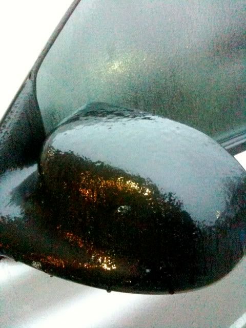
The ice is starting to melt now as temperatures nudge above freezing. This is what it looked like earlier though...
http://i43.photobucket.com/albums/e371/ ... G_1165.jpg
http://i43.photobucket.com/albums/e371/ ... G_1165.jpg
0 likes
Who is online
Users browsing this forum: 869MB, Cpv17, Stratton23, TomballEd and 96 guests