NE Winter Storm / Blizzard
Moderator: S2k Moderators
Forum rules
 The posts in this forum are NOT official forecast and should not be used as such. They are just the opinion of the poster and may or may not be backed by sound meteorological data. They are NOT endorsed by any professional institution or STORM2K.

The posts in this forum are NOT official forecast and should not be used as such. They are just the opinion of the poster and may or may not be backed by sound meteorological data. They are NOT endorsed by any professional institution or STORM2K.


-
cycloneye

- Admin

- Posts: 149688
- Age: 69
- Joined: Thu Oct 10, 2002 10:54 am
- Location: San Juan, Puerto Rico
Re: New England Winter-Strong Nor'easter Nemo for 2/8-2/9
I found the mission in another forum. This mission is to sample the system now in NGOM that will give birth to the strong nor'easter Nemo.

0 likes
Visit the Caribbean-Central America Weather Thread where you can find at first post web cams,radars
and observations from Caribbean basin members Click Here
and observations from Caribbean basin members Click Here


18z GFS is crawling very close to NYC. There are huge snow amounts just in the northern 'burbs and all of Connecticut, RI, and MA. Again a few degrees cooler and I think we can call this a big time KU event effecting 10s of millions.

0 likes
The above post and any post by Ntxw is NOT an official forecast and should not be used as such. It is just the opinion of the poster and may or may not be backed by sound meteorological data. It is NOT endorsed by any professional institution including Storm2k. For official information, please refer to NWS products.
Help support Storm2K!
-
cycloneye
- Admin
- Posts: 149688
- Age: 69
- Joined: Thu Oct 10, 2002 10:54 am
- Location: San Juan, Puerto Rico
Re: New England Winter-Strong Nor'easter Nemo for 2/8-2/9
Here is a press report from AP about the nor'easter. The ski resorts will be packed.
http://bigstory.ap.org/article/skiers-s ... heast-snow
CONCORD, N.H. (AP) — A blizzard heading to New England could make travel nearly impossible and dump up to 2 feet of snow on a region that has seen mostly bare ground this winter.
The snow will start Friday morning, with the heaviest amounts dumped on the region that night and into Saturday as the storm moves through New England and upstate New York, the National Weather Service said.
A blizzard watch for parts of Massachusetts and Rhode Island said travel may become nearly impossible because of high winds and blowing snow.
"This has the potential for being a dangerous storm, especially for Massachusetts into northeast Connecticut and up into Maine," said Louis Uccellini, director of the weather agency's National Centers for Environmental Prediction.
Uccellini, who has written two textbooks on northeastern snowstorms, said Wednesday it was too early to tell if the storm would be one for the record books. But he said it will be a rare and major storm, the type that means "you can't let your guard down."
The storm would hit just after the 35th anniversary of the historic blizzard of 1978, which paralyzed the region with more than 2 feet of snow and hurricane force winds from Feb. 5-7.
No one is wishing for a repeat, but skiers, snowmobilers and other outdoor enthusiasts were hoping for just enough snow to turn around a disappointing season.
The snowmobile season in northern New England started off strong, but after rain and warm temperatures last month, many trails in Maine turned essentially to thick sheets of ice, said Maine Snowmobile Association Executive Director Bob Meyers.
0 likes
Visit the Caribbean-Central America Weather Thread where you can find at first post web cams,radars
and observations from Caribbean basin members Click Here
and observations from Caribbean basin members Click Here
While I don't think the NAM has the right idea regarding track and temp profiles, it's generally decent with qpf and it's spitting out 40+ inches of snow along the MA/RI border  . I know the Euro had 20-30 for some areas before.
0 likes
The above post and any post by Ntxw is NOT an official forecast and should not be used as such. It is just the opinion of the poster and may or may not be backed by sound meteorological data. It is NOT endorsed by any professional institution including Storm2k. For official information, please refer to NWS products.
Help support Storm2K!
Help support Storm2K!
-
brunota2003

- S2K Supporter

- Posts: 9476
- Age: 35
- Joined: Sat Jul 30, 2005 9:56 pm
- Location: Stanton, KY...formerly Havelock, NC
- Contact:
Re:
Ntxw wrote:While I don't think the NAM has the right idea regarding track and temp profiles, it's generally decent with qpf and it's spitting out 40+ inches of snow along the MA/RI border
I saw a post on twitter, using a 10:1 ratio on the NAM, some areas get up to 54 inches of snow! Boston area was in the 48 to 50 inch range!
https://twitter.com/Wright_Weather/stat ... to/1/large
0 likes
Just a small town southern boy helping other humans.

-
cycloneye
- Admin
- Posts: 149688
- Age: 69
- Joined: Thu Oct 10, 2002 10:54 am
- Location: San Juan, Puerto Rico
Re: New England Winter-Strong Nor'easter Nemo for Feb 8-9
Blizzard watch expanded.
AREA FORECAST DISCUSSION
NATIONAL WEATHER SERVICE TAUNTON MA
442 AM EST THU FEB 7 2013
.SYNOPSIS...DRY WEATHER CONTINUES THROUGH TODAY ALONG WITH
SEASONABLY COOL TEMPS. CONFIDENCE CONTINUES TO GROW IN THE
POTENTIAL FOR A HISTORIC WINTER STORM AND BLIZZARD FOR MUCH OF THE
REGION FRI INTO SAT...WITH 1 TO 2 FEET OF SNOW POSSIBLE. THIS
STORM SHOULD COME TO AN END LATER SAT WITH DRY WEATHER CONTINUING
INTO SUN. A MODERATING TREND IS EXPECTED EARLY NEXT WEEK WITH THE
CHANCE OF SOME RAIN SHOWERS.
&&
.NEAR TERM /THROUGH TONIGHT/...
TODAY...HIGH PRESSURE BUILDS INTO SOUTHERN NEW ENGLAND FROM CANADA
THROUGH TODAY. THIS WILL RESULT IN A COLD AND MOSTLY CLEAR START TO
THE MORNING. TEMPERATURES WILL START IN THE SINGLE DIGITS TO TEENS
AND CLIMB INTO THE MID 20S. SKIES WILL BECOME PARTLY TO MOSTLY
CLOUDY AS MID CLOUDS DEVELOP OVER THE AREA AHEAD OF THE STORM WELL
TO THE SOUTH.
TONIGHT...HIGH PRESSURE MOVES OFFSHORE AS LOW PRESSURE MOVES INTO
THE GREAT LAKES AND A SECOND LOW PRESSURE DEVELOPS OFFSHORE NORTH
CAROLINA. THIS WILL ALLOW LOW CLOUDS TO MOVE INTO THE REGION AS
WELL AS POSSIBLY SOME LIGHT SNOW SHOWERS AFTER MIDNIGHT. LOW
TEMPERATURES WILL BE A FEW DEGREES WARMER THAN THIS MORNING BUT
STILL DROPPING INTO THE TEENS MOST LOCATIONS. ANY ACCUMULATIONS
OVERNIGHT WILL BE UNDER AN INCH.
&&
.SHORT TERM /FRIDAY THROUGH SATURDAY NIGHT/...
* POTENTIAL HISTORIC WINTER STORM AND BLIZZARD TO IMPACT MUCH OF
SOUTHERN NEW ENGLAND FRI INTO SAT
* 1 TO 2 FEET OF SNOW POSSIBLE FOR MUCH OF SOUTHERN NEW ENGLAND
EXCEPT AREAS NEAR THE SOUTH COAST WHERE THERE MAY BE SOME MIXING
THE MODELS HAVE COME INTO VERY GOOD AGREEMENT ON A POTENTIALLY
HISTORIC WINTER STORM AND A POSSIBLE BLIZZARD THAT WILL IMPACT MUCH
OF SOUTHERN NEW ENGLAND. WE ARE CONFIDENT THAT MUCH OF THE REGION
WILL RECEIVE 1 TO 2 FEET OF SNOW. STILL TOUGH TO PINPOINT WHERE THE
BEST CHANCE FOR THE HIGHER AMOUNTS WILL BE...BUT CLIMATOLOGY FAVORS
THE I-95 CORRIDOR. WE ALSO EXPECT A MID LEVEL DEFORMATION BAND THAT
WILL LEAD TO LOCALIZED HIGHER AMOUNTS ACROSS THE INTERIOR. THE BULK
OF THE STORM APPEARS TO BE IN THE FRIDAY NIGHT/SATURDAY MORNING TIME
FRAME.
THE HIGHEST LEVEL OF UNCERTAINTY IS ASSOCIATED WITH THE AMOUNT OF
WARM AIR THAT COMES IN AT MID LEVELS FRIDAY AFTERNOON AND EVENING.
THE NAM BRINGS THE WARM AIR THE FARTHEST NORTH UP TO AROUND
PROVIDENCE AND TAUNTON. THE GFS...ECMWF...AND SREF ARE ALL A BIT
MORE CONSERVATIVE KEEPING IT MORE CONFINED TO THE SOUTH COAST.
THIS WOULD RESULT IN A CHANGEOVER TO RAIN OR A MIX OF RAIN...
SNOW...OR SLEET...UNDERCUTTING THE SNOW TOTALS IN THESE AREAS.
SPECIFIC DETAILS...
LIGHT SNOW STILL EXPECTED TO DEVELOP ACROSS SOUTHERN NEW ENGLAND
FRIDAY MORNING AS LOW PRESSURE MOVES OUT OF THE GREAT LAKES AND IS
ABSORBED BY A STRONGER LOW TO THE SOUTH.
A POTENT UPPER LEVEL DISTURBANCE WILL SPAWN A SECONDARY LOW
PRESSURE OFF THE MID ATLANTIC COAST. THIS LOW WILL UNDERGO
EXPLOSIVE DEVELOPMENT AS IT TRACKS NEAR THE BENCHMARK OF 40N/70W
LATE FRIDAY INTO SATURDAY MORNING. IN ADDITION...STRONG HIGH
PRESSURE OVER EASTERN CANADA WILL SUPPLY PLENTY OF COLD AIR. LIGHT
SNOW FRIDAY MORNING WILL BECOME STEADY FRIDAY AFTERNOON AND
INCREASE IN INTENSITY. AS MENTIONED ABOVE...THE BIGGEST
UNCERTAINTY IS HOW FAR THE RAIN/SNOW LINE TEMPORARILY ADVANCES
NORTHWARD.
WE ARE PRETTY SURE THE CAPE/ISLANDS WILL AT LEAST SEE A MIX OF
SNOW AND RAIN...AND PERHAPS FOR A BRIEF PERIOD NEAR THE SOUTH
COAST. IF THE NAM IS CORRECT ITS POSSIBLE THAT THE RAIN/SNOW LINE
MAKES IT INTO RHODE ISLAND AND SOUTHEAST MA.
THE MAIN SHOW LOOKS TO BE FRIDAY NIGHT INTO SATURDAY MORNING AS
THIS LOW BOMBS OUT AND TRACKS NEAR THE BENCHMARK. MID LEVEL
CENTERS RAPIDLY CLOSE OFF WHICH WILL LEAD TO TREMENDOUS SNOWFALL
RATES AND PERHAPS EVEN SOME THUNDER ACCOMPANYING THE STORM. WOULD
EXPECT HOURLY SNOWFALL RATES ON THE ORDER OF 2 TO 3 INCHES PER
HOUR WITH A TREMENDOUS COLD CONVEYER BELT ON THE BACKSIDE OF THIS
SYSTEM.
IN ADDITION...VERY STRONG WINDS OF 50 TO 60 MPH WILL BE BATTERING
THE COASTAL PLAIN LEADING TO CONSIDERABLE BLOWING AND DRIFTING
SNOW. WE MENTIONED THAT CLIMATOLOGY WOULD FAVOR THE I-95 CORRIDOR
AND AREAS A BIT NORTHWEST OF THAT REGION TO RECEIVE THE HIGHEST
SNOW TOTALS. HOWEVER...THERE WILL BE A MID LEVEL DEFORMATION ZONE
THAT SETS UP ACROSS THE INTERIOR ON THE BACK BENT MID LEVEL WARM
FRONT. WHERE EXACTLY THAT SETS UP WILL COME DOWN TO THE MESOSCALE
ENVIRONMENT SO ITS IMPOSSIBLE TO PINPOINT AT THIS TIME. THAT IS
WHY WE ARE LOOKING AT 1 TO 2 FEET OF SNOW ACROSS A GOOD CHUNK OF
THE REGION...EXCEPT NEAR THE SOUTH COAST.
TRAVEL MAY BECOME ALMOST IMPOSSIBLE WITH BLIZZARD CONDITIONS
POSSIBLE. A BLIZZARD WATCH HAS BEEN EXPANDED TO COVER SOUTHERN
WORCESTER COUNTY AS WELL AS ALL OF EASTERN MA...SOUTHERN RHODE
ISLAND AND NORTHERN CONNECTICUT. THIS BLIZZARD WATCH INCLUDES THE
BOSTON TO PROVIDENCE CORRIDOR...GIVEN THE POTENTIAL FOR 50 TO 60
MPH WINDS AND CONSIDERABLE BLOWING AND DRIFTING SNOW. THE TIMING
OF THE BLIZZARD CONDITIONS WILL NOT EXACTLY MATCH THAT OF THE
WATCH AS IT STANDS NOW. THIS TIMING WILL BE REFINED WITH LATER
FORECASTS. THE HIGH WIND WATCHES HAVE BEEN DROPPED IN FAVOR OF THE
BLIZZARD WATCHES
FARTHER SOUTH ALONG THE SOUTH COAST INTO COASTAL PLYMOUTH COUNTY
AND THE CAPE...THERE MAY BE A PERIOD OF SNOW MIXED WITH RAIN OR
EVEN A COMPLETE CHANGEOVER TO RAIN FRIDAY AFTERNOON INTO EARLY
EVENING. IF THAT DOES HAPPEN...THINGS WILL QUICKLY CHANGE TO SNOW
AS LOW PRESSURE EXPLODES OFF THE COAST AND HEIGHTS CRASH.
ACROSS THE ISLANDS...SNOW WILL PROBABLY DEVELOP AND QUICKLY CHANGE
TO RAIN FRIDAY AFTERNOON. RAIN MAY CONTINUE AT TIMES INTO FRIDAY
EVENING...BEFORE THE LOW BOMBS OUT AND THAT REGION FLIPS TO HEAVY
WET SNOW. ACCUMULATIONS ARE MORE UNCERTAIN IN THIS REGION GIVEN THE
TIMING OF THE CHANGE OVER...BUT THE POTENTIAL FOR 6+ INCHES AND
PERHAPS EVEN A PERIOD OF BLIZZARD CONDITIONS INTO SATURDAY WILL BE
POSSIBLE. THE BIG CONCERN IN THAT REGION WILL BE THE POTENTIAL FOR
HURRICANE FORCE WIND GUSTS THAT COULD RESULT IN SOME STRUCTURAL
DAMAGE.
0 likes
Visit the Caribbean-Central America Weather Thread where you can find at first post web cams,radars
and observations from Caribbean basin members Click Here
and observations from Caribbean basin members Click Here
-
cycloneye
- Admin
- Posts: 149688
- Age: 69
- Joined: Thu Oct 10, 2002 10:54 am
- Location: San Juan, Puerto Rico
Re: New England Winter-Strong Nor'easter Nemo for Feb 8-9
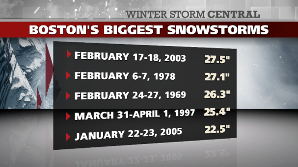
Will nor'easter winter storm Nemo bring higher snow totals than the past historic events to Boston?
0 likes
Visit the Caribbean-Central America Weather Thread where you can find at first post web cams,radars
and observations from Caribbean basin members Click Here
and observations from Caribbean basin members Click Here
-
cycloneye
- Admin
- Posts: 149688
- Age: 69
- Joined: Thu Oct 10, 2002 10:54 am
- Location: San Juan, Puerto Rico
Re: New England Winter-Strong Nor'easter Nemo for Feb 8-9
The NWS offices are on full force with this.
SENIOR DUTY METEOROLOGIST NWS ADMINISTRATIVE MESSAGE
NWS NCEP CENTRAL OPERATIONS COLLEGE PARK MD
1555Z THU FEB 07 2013
A REGIONAL CRITICAL WEATHER DAY...CWD...WILL BE DECLARED AT
0000Z FRI FEB 08 2013 AND EXTEND THROUGH 0000Z SUN FEB 10
2013. THE FOLLOWING NWS REGIONS ARE IMPACTED BY THIS
CWD...EASTERN. NCEP/NWSTG AND THE NCF ARE ALSO
PARTICIPATING IN THIS CWD TO ENSURE A RELIABLE FLOW OF
WEATHER DATA. ALL SCHEDULED SOFTWARE/HARDWARE/NETWORK
CHANGES FOR THE IMPACTED OFFICES WILL BE POSTPONED UNTIL
THE CWD HAS ENDED. ANY EMERGENCY CHANGES WILL BE EVALUATED
AND APPROVED BY THE LOCAL/REGIONAL MANAGEMENT OFFICIALS.
NWS OFFICES SHOULD CONTACT THEIR REGIONAL OFFICES FOR
FURTHER QUESTIONS ABOUT THIS CWD.
ALERT ADMINISTRATIVE MESSAGE
NATIONAL WEATHER SERVICE EASTERN REGION HEADQUARTERS BOHEMIA NY
1115 AM EST THU FEB 7 2013
TO: ALY...BGM...BOX...BTV...CAR...CTP...GYX...OKX...PH I...VUY...NERFC
FM: ERH
YOU SHOULD HAVE RECEIVED TELCON INFORMATION FOR NOON COLLABORATION
CALL VIA NIMNAT MESSAGE. IF YOU HAVE NOT, PLEASE CONTACT ERH_1 ON
12PLANET.
0 likes
Visit the Caribbean-Central America Weather Thread where you can find at first post web cams,radars
and observations from Caribbean basin members Click Here
and observations from Caribbean basin members Click Here
-
cycloneye
- Admin
- Posts: 149688
- Age: 69
- Joined: Thu Oct 10, 2002 10:54 am
- Location: San Juan, Puerto Rico
Re: New England Winter-Strong Nor'easter Nemo for Feb 8-9
This is the HPC discussion about the latest model runs.
MODEL DIAGNOSTIC DISCUSSION
NWS HYDROMETEOROLOGICAL PREDICTION CENTER COLLEGE PARK MD
1153 AM EST THU FEB 07 2013
VALID FEB 07/1200 UTC THRU FEB 11/0000 UTC
...SRN STREAM ENERGY AMPLIFYING OFFSHORE OF THE NERN U.S...
...RAPID COASTAL CYCLOGENESIS OCCURRING ACRS THE WRN ATLC...
PRELIMINARY PREFERENCE/FCST CONFIDENCE: BLEND OF THE 00Z ECMWF AND
06Z GEFS MEAN/00Z ECMWF ENS MEAN (MEDIUM CONFIDENCE)
AN ELONGATED AXIS OF SHRTWV ENERGY MOVING THRU THE SERN U.S. IS
CURRENTLY PRODUCING MDT TO HEAVY PCPN ACRS THE ERN GULF COAST. AS
THIS SYSTEM LIFTS N AND E...IT WILL BEGIN TO INTENSIFY ALONG THE
OUTER BANKS ON FRI MORNING WITH THE AFOREMENTIONED PHASING
OCCURRING WITH THE NRN STREAM. CONSEQUENTLY...RAPID CYCLOGENESIS
IS EXPECTED TO OCCUR WITH THIS WAVE CONTINUING TO DEEPEN WHILE
MOVING E OF NEW ENGLAND LATE FRI/EARLY SAT. NOTABLE SHIFTS IN THE
NAM ARE EVIDENT AS THE 12Z RUN HAS TRENDED STRONGER WITH THE
TROF/SFC LOW ACRS THE OUTER BANKS ON 08/1200Z. THIS CONTINUES
FURTHER INTO THE PERIOD AS THE 12Z NAM IS STRONGER AND MORE TO THE
N/W RELATIVE TO ITS EARLIER RUNS. EVENTUALLY IT BEGINS LOOKING
LIKE THE 06Z RUN ACRS RI BY SAT MORNING. ON THE CONTRARY...THE 12Z
GFS APPEARS TO GENERALLY FOLLOW SUIT WITH PREVIOUS RUNS ALTHOUGH
SOME CHANGES ARE NOTED LATER IN THE PERIOD. MORE
SPECIFICALLY...THE 12Z GFS HAS MOVED SLGTLY TO THE W WHILE BEING A
FEW MB DEEPER...PARTICULARLY AFTER FRI EVENING ACRS COASTAL NEW
ENGLAND. RELATIVE TO OTHER GUIDANCE...THERE IS SOME SPREAD WITH
THE LOW CENTER OVER THE OUTER BANKS WITH THE 12Z NAM FOLLOWING
SUIT WITH THE 00Z ECMWF/ECMWF ENS MEAN. AGAIN...THE MOST OUTLYING
SOLN APPEARS TO BE THE 00Z UKMET WHICH IS WEAKER AND MORE
OFFSHORE. THE FOLLOWING 12 HRS ARE MOST CRUCIAL WHERE MODELS BEGIN
DIVERGING ON A PARTICULAR SOLN. AT 09/0000Z...THE 12Z NAM ENDS UP
BEING THE FARTHEST W MODEL WITH THE 00Z ECMWF/ECMWF ENS MEAN JUST
OFF TO ITS E. FURTHER...THE 12Z GFS/06Z GEFS MEAN IS E OF THE
ECMWF SUITE OF SOLNS WHICH HAS BEEN NOTED IN THE PAST SEVERAL ENS
RUNS. THE ENS SFC LOW PLOTS ACCURATELY DEPICT THIS DIVERGING OF
OPINIONS ALBEIT WITH DIMINISHING SPREAD RELATIVE TO FEB 6
(00Z/12Z) GUIDANCE. ON A SIDE...THE 00Z UKMET IS THE MOST OFFSHORE
SOLN WITH NO SUPPORT AT THIS TIME. THE CURRENT THINKING IS TO GO
HALFWAY BETWEEN THE RECENT 12Z NAM/GFS SOLNS WHICH WOULD MAKE THE
00Z ECMWF A REASONABLE STARTING PT. GIVEN THE
UNCERTAINTY...COMBINING THE 00Z ECMWF WITH THE 06Z GEFS MEAN/00Z
ECMWF ENS MEAN WOULD BE PRUDENT HERE.
0 likes
Visit the Caribbean-Central America Weather Thread where you can find at first post web cams,radars
and observations from Caribbean basin members Click Here
and observations from Caribbean basin members Click Here
It's time for some now cast now that the KU storm is less than 24 hours from beginning. Both jets look poised to merge (subtropical and polar) with the disturbances leading the way for bombogenesis off the Virginia capes.


0 likes
The above post and any post by Ntxw is NOT an official forecast and should not be used as such. It is just the opinion of the poster and may or may not be backed by sound meteorological data. It is NOT endorsed by any professional institution including Storm2k. For official information, please refer to NWS products.
Help support Storm2K!
Help support Storm2K!
-
cycloneye
- Admin
- Posts: 149688
- Age: 69
- Joined: Thu Oct 10, 2002 10:54 am
- Location: San Juan, Puerto Rico
Re: New England Winter-Strong Nor'easter Nemo for Feb 8-9
Yikes! 
Ryan Maue@RyanMaue
Canadian 10km regional model explosively develops & stalls warm-seclusion blizzard off tip of New Eng 972 mb +48hrs

Ryan Maue@RyanMaue
Canadian 10km regional model explosively develops & stalls warm-seclusion blizzard off tip of New Eng 972 mb +48hrs
0 likes
Visit the Caribbean-Central America Weather Thread where you can find at first post web cams,radars
and observations from Caribbean basin members Click Here
and observations from Caribbean basin members Click Here
-
cycloneye
- Admin
- Posts: 149688
- Age: 69
- Joined: Thu Oct 10, 2002 10:54 am
- Location: San Juan, Puerto Rico
Re:
Ntxw wrote:It's time for some now cast now that the KU storm is less than 24 hours from beginning. Both jets look poised to merge (subtropical and polar) with the disturbances leading the way for bombogenesis off the Virginia capes.
http://i46.tinypic.com/5z4kn8.gif
http://i45.tinypic.com/35i61w5.png
http://i45.tinypic.com/9tlv94.gif
Wow,is amazing how all the atmosphere works to form a bomb.
0 likes
Visit the Caribbean-Central America Weather Thread where you can find at first post web cams,radars
and observations from Caribbean basin members Click Here
and observations from Caribbean basin members Click Here
-
cycloneye
- Admin
- Posts: 149688
- Age: 69
- Joined: Thu Oct 10, 2002 10:54 am
- Location: San Juan, Puerto Rico
Re: New England Winter-Strong Nor'easter Nemo for Feb 8-9
He will need to use that a lot.
Mike Seidel @mikeseidel
Look who is sitting across from me on my flight to Boston. And why does he keep poking me with that yardstick?

Mike Seidel @mikeseidel
Look who is sitting across from me on my flight to Boston. And why does he keep poking me with that yardstick?
0 likes
Visit the Caribbean-Central America Weather Thread where you can find at first post web cams,radars
and observations from Caribbean basin members Click Here
and observations from Caribbean basin members Click Here
Euro and NAM seem to be leading the way on big snow totals for NYC 15-20" while the GFS is under a foot and half a foot in Philadelphia. New England is big on every model. At this rate since the Euro has led from the beginning I would trust that model. Crippling storm for sure.
0 likes
The above post and any post by Ntxw is NOT an official forecast and should not be used as such. It is just the opinion of the poster and may or may not be backed by sound meteorological data. It is NOT endorsed by any professional institution including Storm2k. For official information, please refer to NWS products.
Help support Storm2K!
Help support Storm2K!
-
cycloneye
- Admin
- Posts: 149688
- Age: 69
- Joined: Thu Oct 10, 2002 10:54 am
- Location: San Juan, Puerto Rico
Re: New England Winter-Strong Nor'easter Nemo for Feb 8-9
12z ECMWF snowfall projection. 

0 likes
Visit the Caribbean-Central America Weather Thread where you can find at first post web cams,radars
and observations from Caribbean basin members Click Here
and observations from Caribbean basin members Click Here
-
tomboudreau

- Category 5

- Posts: 1869
- Age: 49
- Joined: Tue Feb 18, 2003 6:07 pm
- Location: Carnegie, PA
- Contact:
Looks like the watches are transitioning to warnings. First blizzard warnings are up for the coast of Maine and winter storm warnings for the Philly/NJ areas. Plenty of lead time for folks to prepare hopefully no one gets stranded by not paying attention to the weather forecasts.
Edit: Would not be at all surprised if NYC gets under the blizzard warning bunch. Much of long Island will be.
Edit: Would not be at all surprised if NYC gets under the blizzard warning bunch. Much of long Island will be.
Last edited by Ntxw on Thu Feb 07, 2013 3:40 pm, edited 1 time in total.
0 likes
The above post and any post by Ntxw is NOT an official forecast and should not be used as such. It is just the opinion of the poster and may or may not be backed by sound meteorological data. It is NOT endorsed by any professional institution including Storm2k. For official information, please refer to NWS products.
Help support Storm2K!
Help support Storm2K!
-
angelwing

- S2K Supporter
- Posts: 4462
- Age: 64
- Joined: Tue Jan 18, 2005 3:06 pm
- Location: Kulpsville, PA
Re: New England Winter-Strong Nor'easter Nemo for Feb 8-9
I posted this in Mid-Atlantic:
The National Weather Service in Mount Holly has Issued a Winter
storm Warning for Heavy Snow, Which is in effect from 3 Pm
Friday to 6am EST Saturday.
* Locations, Southeast Pennsylvania West and North of Philadelphia
Into South Central New Jersey.
* Hazard Types, Heavy Snow.
* Accumulations, Snow Accumulation of 4 to 8 Inches, Along With
Possibly a Trace of Ice.
* Timing, Any Snow Friday Morning will Change Rain During The
Daylight Hours then Back to Heavy Snow Late in the Day Friday Or
Friday Evening. One to 2 Inch Per Hour Accumulations are Possible
for a Couple of Hours Friday Night. Northerly winds will Gust 30
MPH Causing Blowing and Drifting. There is a Small Chance for A
thunderstorm with the Snow.
* Impacts, very Hazardous Travel is Expected for the Friday
Evening Commute and Well Into the Night with Visibility Down to
One Quarter Mile at Times. Isolated Power Outages are Possible.
* Temperatures, Mostly Just Above Freezing During the Day Falling
to 25 to 30 at Night.
* Confidence, this Region is Probably Going to be on the Edge Of
The Heavy Snow and Amounts May Vary from What is Currently
Expected.
Precautionary/preparedness Actions
A Winter storm Warning Means Significant Amounts of Snow
Sleet, and Ice are Expected or Occurring. Strong winds are Also
Possible. this will Make Travel very Hazardous or Impossible.
Low Pressure Developing near the Coastal Carolina's Late today...
will Rapidly Intensify As It Moves to a Position 100 to 150 Miles
East of Atlantic City Late Friday Afternoon then to near Nantucket
Early Saturday.
The Potentially Dangerous Portion of this storm is for the Friday
Evening Rush Hour Into the Wee Hours of Saturday Morning When
Treacherous Road Conditions are Expected to Develop.
be Prepared for Major Travel Delays Late Friday and Friday Night.
Expires 2/7/13 11:30 PM
0 likes
Who is online
Users browsing this forum: No registered users and 148 guests