Winter 2010-11 for the Southern Plains

Winter Weather Discussion

Moderator: S2k Moderators

Forum rules

The posts in this forum are NOT official forecast and should not be used as such. They are just the opinion of the poster and may or may not be backed by sound meteorological data. They are NOT endorsed by any professional institution or STORM2K.

Help Support Storm2K
Message
Author
User avatar
Ntxw
Storm2k Moderator
Storm2k Moderator
Posts: 22784
Joined: Wed Oct 21, 2009 6:34 pm
Location: DFW, Texas

Re: Winter 2010-11 for the Southern Plains

#201 Postby Ntxw » Mon Nov 15, 2010 4:54 pm

somethingfunny wrote:Looks to me like that run has it missing us off to the east.


Don't look so much into the details but rather trend that the EC is depicting, the arctic air is making it's way south down the plains heading northeast vs bottling it up (with the ridge in and around FL I wouldn't buy into the solution of coldest air aiming east of Tx yet). Heights shooting up out west and lowering east.
0 likes   
The above post and any post by Ntxw is NOT an official forecast and should not be used as such. It is just the opinion of the poster and may or may not be backed by sound meteorological data. It is NOT endorsed by any professional institution including Storm2k. For official information, please refer to NWS products.

  Help support Storm2K!
Help Support Storm2K

User avatar
Portastorm
Storm2k Moderator
Storm2k Moderator
Posts: 9914
Age: 63
Joined: Fri Jul 11, 2003 9:16 am
Location: Round Rock, TX
Contact:

Re: Winter 2010-11 for the Southern Plains

#202 Postby Portastorm » Tue Nov 16, 2010 7:35 am

The 0z GFS is still on board with a dump of Polar air into the Southern Plains with frontal passage through Texas on Thanksgiving Day. The 0z Euro, though, looks even more interesting to me. If I'm reading this right, looks like the Euro also dumps Polar air into the Southern Plains but lags a 500mb trough in the Southwest. Can anyone say overrunning with very cold air? Could mean a freezing precip threat for the Panhandle, Red River area, and Oklahoma.

The 0z Euro at 240 hrs:

Image

Uploaded with ImageShack.us
0 likes   

User avatar
srainhoutx
S2K Supporter
S2K Supporter
Posts: 6919
Age: 67
Joined: Sun Jan 14, 2007 11:34 am
Location: Haywood County, NC
Contact:

Re: Winter 2010-11 for the Southern Plains

#203 Postby srainhoutx » Tue Nov 16, 2010 7:48 am

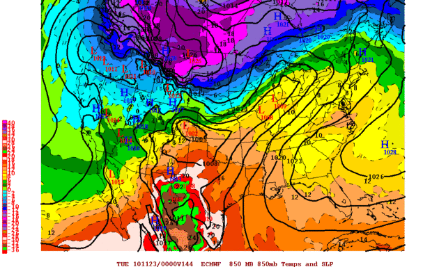
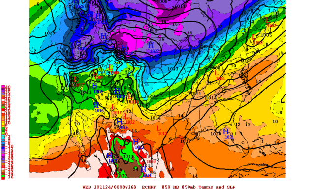
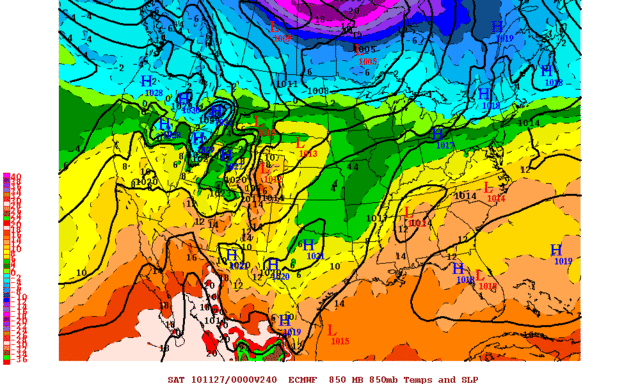
Portastorm wrote:The 0z GFS is still on board with a dump of Polar air into the Southern Plains with frontal passage through Texas on Thanksgiving Day. The 0z Euro, though, looks even more interesting to me. If I'm reading this right, looks like the Euro also dumps Polar air into the Southern Plains but lags a 500mb trough in the Southwest. Can anyone say overrunning with very cold air? Could mean a freezing precip threat for the Panhandle, Red River area, and Oklahoma.


Someone caught my Oh Boy statement yesterday. :cheesy: 
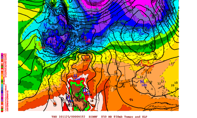
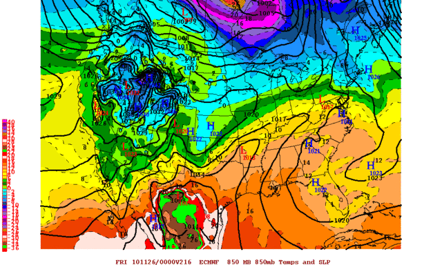
Also of note is the continued cross polar flow just beyond Thanksgiving. This pattern may have a surprise or two up it's sleeve before all is said and done, IMO.

Euro Day 10 500mb Anomalies

Image

GFS 2 Meter Temps @ 372 Hours

Image
0 likes   
Carla/Alicia/Jerry(In The Eye)/Michelle/Charley/Ivan/Dennis/Katrina/Rita/Wilma/Ike/Harvey

Member: National Weather Association
Wx Infinity Forums
http://wxinfinity.com/index.php

Facebook.com/WeatherInfinity
Twitter @WeatherInfinity

User avatar
srainhoutx
S2K Supporter
S2K Supporter
Posts: 6919
Age: 67
Joined: Sun Jan 14, 2007 11:34 am
Location: Haywood County, NC
Contact:

Re: Winter 2010-11 for the Southern Plains

#204 Postby srainhoutx » Tue Nov 16, 2010 3:01 pm

12Z Euro 850 temp anomalies are certainly down right chilly...

Image
0 likes   
Carla/Alicia/Jerry(In The Eye)/Michelle/Charley/Ivan/Dennis/Katrina/Rita/Wilma/Ike/Harvey

Member: National Weather Association
Wx Infinity Forums
http://wxinfinity.com/index.php

Facebook.com/WeatherInfinity
Twitter @WeatherInfinity

User avatar
TwisterFanatic
Category 5
Category 5
Posts: 1041
Joined: Mon Jun 28, 2010 12:43 pm
Location: Sallisaw, Oklahoma

#205 Postby TwisterFanatic » Tue Nov 16, 2010 4:03 pm

Chilly is a understatement. :lol:
0 likes   
Personal Forecast Disclaimer:
The posts in this forum are NOT official forecast and should not be used as such. They are just the opinion of the poster and may or may not be backed by sound meteorological data. They are NOT endorsed by any professional institution or storm2k.org. For official information, please refer to the NHC and NWS products.

User avatar
TwisterFanatic
Category 5
Category 5
Posts: 1041
Joined: Mon Jun 28, 2010 12:43 pm
Location: Sallisaw, Oklahoma

#206 Postby TwisterFanatic » Tue Nov 16, 2010 10:22 pm

There was actually a unexpected light dusting of snow in Central Arkansas last night. Lightly coated decks and cars.
0 likes   
Personal Forecast Disclaimer:
The posts in this forum are NOT official forecast and should not be used as such. They are just the opinion of the poster and may or may not be backed by sound meteorological data. They are NOT endorsed by any professional institution or storm2k.org. For official information, please refer to the NHC and NWS products.

User avatar
Extremeweatherguy
Category 5
Category 5
Posts: 11095
Joined: Mon Oct 10, 2005 8:13 pm
Location: Florida

Re:

#207 Postby Extremeweatherguy » Tue Nov 16, 2010 11:31 pm

TwisterFanatic wrote:There was actually a unexpected light dusting of snow in Central Arkansas last night. Lightly coated decks and cars.
Hmm, really? Looking at the models yesterday I had suspected something like that might happen in eastern Oklahoma or Arkansas, but I never knew if it actually materialized. Interesting to hear that it did.
0 likes   

User avatar
TwisterFanatic
Category 5
Category 5
Posts: 1041
Joined: Mon Jun 28, 2010 12:43 pm
Location: Sallisaw, Oklahoma

Re: Winter 2010-11 for the Southern Plains

#208 Postby TwisterFanatic » Wed Nov 17, 2010 12:13 am

Here is a picture..

Image
0 likes   
Personal Forecast Disclaimer:
The posts in this forum are NOT official forecast and should not be used as such. They are just the opinion of the poster and may or may not be backed by sound meteorological data. They are NOT endorsed by any professional institution or storm2k.org. For official information, please refer to the NHC and NWS products.

User avatar
Extremeweatherguy
Category 5
Category 5
Posts: 11095
Joined: Mon Oct 10, 2005 8:13 pm
Location: Florida

#209 Postby Extremeweatherguy » Wed Nov 17, 2010 12:58 am

Thanks for the picture. Very interesting. Looks like it was those nice fat flakes that usually occur when the temperature is above freezing. Too bad that changeover couldn't have happened a little further west..
0 likes   

User avatar
Extremeweatherguy
Category 5
Category 5
Posts: 11095
Joined: Mon Oct 10, 2005 8:13 pm
Location: Florida

#210 Postby Extremeweatherguy » Wed Nov 17, 2010 2:09 am

Tonight's 00z GFS continues to look cold starting next week. The 00z ECMWF, on the other hand, looks strange. It is completely different from its chilly 12z run. It is showing a push of cold air working down the plains by Tuesday evening, but then it gets odd; lifting the cold back north, then sending it back down Thanksgiving day in a much weaker (not as cold) form. By Friday, the 0C 850mb line is all the way up in the Dakotas! Overall, I don't think the 00z ECMWF has a very good grasp on the situation, and is improperly handling the cold airmass. Hopefully the 12z ECMWF can come back to reality.

MON EVE: http://i43.photobucket.com/albums/e371/ ... PUS144.gif
TUES EVE: http://i43.photobucket.com/albums/e371/ ... PUS168.gif
WED EVE: http://i43.photobucket.com/albums/e371/ ... PUS192.gif
THUR EVE: http://i43.photobucket.com/albums/e371/ ... S216-2.gif
FRI EVE: http://i43.photobucket.com/albums/e371/ ... S240-2.gif
0 likes   

User avatar
srainhoutx
S2K Supporter
S2K Supporter
Posts: 6919
Age: 67
Joined: Sun Jan 14, 2007 11:34 am
Location: Haywood County, NC
Contact:

Re: Winter 2010-11 for the Southern Plains

#211 Postby srainhoutx » Wed Nov 17, 2010 7:15 am

Dodge City, KS WFO again offers a great discussion on how things will likely play out regarding the Arctic Front and reinforcing shots of cold air as well as the forces at work...

DAYS 3-7...

TEMPERATURES WILL CONTINUE TO BE EXTREMELY DIFFICULT TO FORECAST IN
THE EXTENDED PERIOD AS SHALLOW COLD AIR SLOSHES BACK AND FORTH
ACROSS WESTERN KANSAS IN RESPONSE TO MINOR WAVES RIPPLING THROUGH
THE FLOW. CONFIDENCE IN THE OSCILLATIONS OF THE SHALLOW COLD AIR
POOL IS LOW, AND THE POTENTIAL FOR MAJOR TEMPERATURE FORECAST
MISSES IS HIGH.

STRONG RIDGING IS IN PROGRESS JUST EAST OF THE DATELINE, AND
DOWNSTREAM AMPLIFICATION OF THE LONG WAVE TROUGH IN THE EASTERN
PACIFIC WILL OCCUR AS A STRONG JET STREAK MOVES OVER THE TOP OF THE
DATELINE RIDGE AND DIVES SOUTHWARD AROUND 130W BY SATURDAY. THE
VIGOROUS UPPER LEVEL TROUGH EVIDENT ON SATELLITE IMAGERY NEAR
52N/142W EARLY THIS MORNING WILL PROPAGATE EASTWARD INTO WESTERN
ONTARIO BY FRIDAY MORNING. A RESERVOIR OF COLD AIR CONTINUES TO
BUILD IN CANADA WITH SURFACE TEMPERATURES IN THE SINGLE DIGITS AS
FAR SOUTH AS SOUTHERN ALBERTA AND CENTRAL SASKATCHEWAN. AS THE UPPER
LEVEL TROUGH MOVES THROUGH SOUTHERN CANADA, A PORTION OF THIS COLD
AIR RESERVOIR WILL SURGE SOUTHWARD INTO NORTHERN KANSAS BY FRIDAY
MORNING AND SHOULD MOVE ACROSS ALL OF SOUTHWEST KANSAS BY FRIDAY
EVENING. TEMPERATURES FRIDAY WILL BE VERY WARM AHEAD OF THE BOUNDARY
AND SHOULD APPROACH 70 DEGREES ALONG THE OKLAHOMA BORDER.

PERSISTENT UPSLOPE FLOW AND ISENTROPIC LIFTING OVER THE SHALLOW COLD
AIR LIKELY WILL SUPPORT FORMATION OF AN AREA OF STRATUS IN
NORTHWESTERN KANSAS LATE FRIDAY NIGHT INTO SATURDAY. THE MOIST LAYER
MAY BE DEEP ENOUGH TO SUPPORT DEVELOPMENT OF VERY LIGHT DRIZZLE OR
FREEZING DRIZZLE FOR A FEW HOURS, BUT THE SURFACE WILL BE WARM
ENOUGH THAT ANY FREEZING DRIZZLE THAT DOES FALL WILL HAVE MINIMAL
IMPACT ON ROADWAYS. THE SHALLOW COLD AIR WILL REMAIN ENTRENCHED
ACROSS MOST OF SOUTHWEST KANSAS SATURDAY, AND THE STRATUS WILL BE
VERY SLOW TO ERODE. SOME EROSION OF THE COLD AIR IS LIKELY SINCE
MOST OF SOUTHWEST KANSAS WILL HAVE ONLY THIN, HIGH CLOUDINESS
SATURDAY, AND THE ECMWF SOLUTION OF SPREADING WARM AIR BACK TOWARD
MORTON COUNTY DURING THE AFTERNOON LOOKS REASONABLE.

STRONG SOUTHWEST FLOW ABOVE THE SURFACE WILL DEVELOP SATURDAY NIGHT
AS AN UPPER LEVEL TROUGH MOVES FROM THE SOUTHWESTERN PART OF THE
COUNTRY TO THE WESTERN DAKOTAS BY SUNDAY MORNING, AND THE COLD AIR
LIKELY WILL RETREAT TO AT LAST NORTHERN KANSAS BY SUNDAY MORNING.
ONCE AGAIN SUNDAY, THE SHARP BAROCLINIC ZONE ALONG THE EDGE OF THE
SHALLOW COLD POOL WILL BEGIN TO PUSH BACK SOUTHWARD BEHIND THE UPPER
LEVEL TROUGH. VERY WARM TEMPERATURES CAN BE EXPECTED IN THE WARM
SECTOR ALONG THE OKLAHOMA BORDER, WHILE TEMPERATURES ARE ABOUT 20
DEGREES COOLER ALONG INTERSTATE 70.

YET ANOTHER UPPER LEVEL TROUGH WILL MOVE THROUGH THE SOUTHWESTERLY
UPPER LEVEL FLOW MONDAY, AND THE BOUNDARY ONCE AGAIN WILL LIFT
NORTHWARD AND SUBSEQUENTLY SURGE BACK SOUTH ACROSS WESTERN KANSAS. A
MORE SIGNIFICANT SURGE OF COLD AIR STILL APPEARS LIKELY TO INVADE
KANSAS MONDAY NIGHT AS A STRONGER TROUGH ROTATES AROUND THE POLAR
VORTEX WEST OF HUDSON BAY AND DISLODGES A BIGGER PIECE OF THE COLD
AIR RESERVOIR.


Image
0 likes   
Carla/Alicia/Jerry(In The Eye)/Michelle/Charley/Ivan/Dennis/Katrina/Rita/Wilma/Ike/Harvey

Member: National Weather Association
Wx Infinity Forums
http://wxinfinity.com/index.php

Facebook.com/WeatherInfinity
Twitter @WeatherInfinity

User avatar
Ntxw
Storm2k Moderator
Storm2k Moderator
Posts: 22784
Joined: Wed Oct 21, 2009 6:34 pm
Location: DFW, Texas

Re: Winter 2010-11 for the Southern Plains

#212 Postby Ntxw » Wed Nov 17, 2010 7:25 am

For what it's worth, northern Canada and Alaska is getting colder from what was seen previously. Perhaps a sign of things to come from the source region.

Image

Image
0 likes   
The above post and any post by Ntxw is NOT an official forecast and should not be used as such. It is just the opinion of the poster and may or may not be backed by sound meteorological data. It is NOT endorsed by any professional institution including Storm2k. For official information, please refer to NWS products.


  Help support Storm2K!

Help Support Storm2K


User avatar
srainhoutx
S2K Supporter
S2K Supporter
Posts: 6919
Age: 67
Joined: Sun Jan 14, 2007 11:34 am
Location: Haywood County, NC
Contact:

Re: Winter 2010-11 for the Southern Plains

#213 Postby srainhoutx » Wed Nov 17, 2010 8:58 am

PRELIMINARY EXTENDED FORECAST DISCUSSION
NWS HYDROMETEOROLOGICAL PREDICTION CENTER CAMP SPRINGS MD
827 AM EST WED NOV 17 2010

VALID 12Z SUN NOV 21 2010 - 12Z WED NOV 24 2010

A TROUGH/RIDGE PATTERN ALOFT SHOULD HOLD TIGHT OVER THE CONUS IN
THE MEDIUM RANGE PERIOD FROM WEST TO EAST AS UPSTREAM NE PACIFIC
RIDGING SHOWS NO SIGN OF QUICKLY FADING. TELECONNECTIONS FROM A
POSITIVE HEIGHT ANOMALY SOUTH OF THE GULF OF ALASKA SHOWS A STRONG
SIGNAL DOWNSTREAM THAT INCLUDES MID-UPPER LEVEL RIDGING OVER THE
SE CONUS. MODELS REMAIN IN GOOD AGREEMENT AND ENSEMBLES EVEN MORE
SO...SUGGESTING BETTER THAN NORMAL FORECAST CONFIDENCE.


IN THIS FLOW...THE 00/06Z GFS RUNS CONTINUE TO DEVELOP A SURFACE
WAVE FARTHER NORTHWEST ACROSS SE WY BY SUN/D4 WHILE THE 00Z
ECMWF/UKMET/CANADIAN PUSH THE COLD AIRMASS FARTHER SOUTH INTO THE
CENTRAL PLAINS. THEREAFTER...THE 00/06Z GFS RUNS LAG MOST OTHER
GUIDANCE WITH THIS SURGE SO ITS SOLUTION WAS DOWNPLAYED
CONSIDERING CONTINUITY
.
THE 00Z ECMWF/CANADIAN FOLLOWED MUCH MORE
CLOSELY TO CONTINUITY AND HAD BETTER OVERALL ENSEMBLE MEAN
SUPPORT. HOWEVER BY EARLY NEXT WEEK...THE 00Z ECMWF DOES PULL
DOWN A POTENT PIECE OF ENERGY ALOFT FROM THE CENTRAL CANADIAN
VORTEX THROUGH EASTERN WA/OR. THIS IS QUITE A CHANGE FROM ITS
CONTINUITY AND SEEMINGLY IS A LESS PREDICTABLE SMALL-MID SCALE
FEATURE.
ACCORDINGLY TONED DOWN THAT EXPLICIT FORECAST WITH A 50
PERCENT BLENDING/WEIGHTING FROM THE ECMWF ENSEMBLE MEAN FOR DAYS
5-7 MON-WED. DIFFERENCES FARTHER EAST ACROSS THE CONUS AND
VICINITY BY THEN BECOME LESS NOTICEABLE FOR NOW SO OVERALL OUR
UPDATED PRELIM PROGS MAINTAIN CLOSE HPC CONTINUITY.

FRACASSO/SCHICHTEL
0 likes   
Carla/Alicia/Jerry(In The Eye)/Michelle/Charley/Ivan/Dennis/Katrina/Rita/Wilma/Ike/Harvey

Member: National Weather Association
Wx Infinity Forums
http://wxinfinity.com/index.php

Facebook.com/WeatherInfinity
Twitter @WeatherInfinity

User avatar
Ntxw
Storm2k Moderator
Storm2k Moderator
Posts: 22784
Joined: Wed Oct 21, 2009 6:34 pm
Location: DFW, Texas

#214 Postby Ntxw » Wed Nov 17, 2010 2:01 pm

Crazy flip flops continue, 12z euro is colder and has a storm with lots of cold air coming in from the west digging into the southwest for Thanksgiving.
0 likes   
The above post and any post by Ntxw is NOT an official forecast and should not be used as such. It is just the opinion of the poster and may or may not be backed by sound meteorological data. It is NOT endorsed by any professional institution including Storm2k. For official information, please refer to NWS products.


  Help support Storm2K!

Help Support Storm2K


User avatar
TwisterFanatic
Category 5
Category 5
Posts: 1041
Joined: Mon Jun 28, 2010 12:43 pm
Location: Sallisaw, Oklahoma

#215 Postby TwisterFanatic » Wed Nov 17, 2010 2:08 pm

Do you have a link to the EURO? My link isn't wanting to work today.
0 likes   
Personal Forecast Disclaimer:
The posts in this forum are NOT official forecast and should not be used as such. They are just the opinion of the poster and may or may not be backed by sound meteorological data. They are NOT endorsed by any professional institution or storm2k.org. For official information, please refer to the NHC and NWS products.

User avatar
Ntxw
Storm2k Moderator
Storm2k Moderator
Posts: 22784
Joined: Wed Oct 21, 2009 6:34 pm
Location: DFW, Texas

Re:

#216 Postby Ntxw » Wed Nov 17, 2010 2:16 pm

TwisterFanatic wrote:Do you have a link to the EURO? My link isn't wanting to work today.


http://www.ecmwf.int/

Image

Image

Image
0 likes   
The above post and any post by Ntxw is NOT an official forecast and should not be used as such. It is just the opinion of the poster and may or may not be backed by sound meteorological data. It is NOT endorsed by any professional institution including Storm2k. For official information, please refer to NWS products.


  Help support Storm2K!

Help Support Storm2K


HockeyTx82
S2K Supporter
S2K Supporter
Posts: 2540
Joined: Tue Oct 27, 2009 11:17 am
Location: Ponder, TX

Re: Winter 2010-11 for the Southern Plains

#217 Postby HockeyTx82 » Wed Nov 17, 2010 3:38 pm

From http://local.msn.com/ten-day.aspx?q=Denton-TX&zip=76201

Monday
Nov 22
Scattered Thunderstorms

Hi:69°Lo:54°
Scattered Thunderstorms. High 69F and low 54F. Winds S at 11 mph. Air Quality:NA, UV Index:NA
20%
Tuesday
Nov 23
Scattered Thunderstorms

Hi:65°Lo:59°
Scattered Thunderstorms. High 65F and low 59F. Winds N at 8 mph. Air Quality:NA, UV Index:NA
20%
Wednesday
Nov 24
Showers

Hi:69°Lo:40°
Showers. High 69F and low 40F. Winds N at 11 mph. Air Quality:NA, UV Index:NA
40%
Thursday
Nov 25
Showers

Hi:72°Lo:27°
Showers. High 72F and low 27F. Winds N at 14 mph. Air Quality:NA, UV Index:NA
70%
Friday
Nov 26
Sunny (Clear)

Hi:39°Lo:30°
Sunny. High 39F and low 30F. Winds N at 3 mph. Air Quality:NA, UV Index:NA
0 likes   
Don't hold me accountable for anything I post on this forum. Leave the real forecasting up to the professionals.

Location: Ponder, TX (all observation posts are this location unless otherwise noted)

User avatar
wall_cloud
Professional-Met
Professional-Met
Posts: 401
Age: 48
Joined: Sun Dec 04, 2005 7:32 am
Location: Bartlett, TN
Contact:

Re: Winter 2010-11 for the Southern Plains

#218 Postby wall_cloud » Thu Nov 18, 2010 4:34 am

If the runs continue to mimic the latest ECMWF H5 panels displayed above then we will have to seriously watch out for that cold air intrusion. Several days ago the ECMWF showed something somewhat similar with more of a closed mid level circulation at the base on the trof while the GFS maintained a slightly more progressive open wave. If this farther south, and stronger wave at the base plays out, it would be apt to induce surface cyclogenesis farther south enhancing the cold advection behind the front. However, we are still looking at at times well beyond my comfort zone. It also looks like the newer 00Z ECMWF is slightly faster and not as deep. Still not getting my hopes up for a significant cold front in west central TX but I see a pretty good front coming out way at least. The colder air is likely to be shunted farther east but there is still plenty of time for me to be wrong on many more occasions. I'm back on shift Thursday night so we'll see how it looks then.
0 likes   
My comments are my own and do not reflect those of NOAA or the National Weather Service.

User avatar
srainhoutx
S2K Supporter
S2K Supporter
Posts: 6919
Age: 67
Joined: Sun Jan 14, 2007 11:34 am
Location: Haywood County, NC
Contact:

Re: Winter 2010-11 for the Southern Plains

#219 Postby srainhoutx » Thu Nov 18, 2010 8:59 am

Updated HPC Prelim discussion is painting an interesting scenario regarding the models and the Upper Air feature lagging in the SW next week...

...UPDATED MORNING PRELIMS...
A CHANGE IN CONTINUITY IS PREFERRED FROM THE OVERNIGHT PROGS AS
06Z GFS HAS BECOME MORE SIMILAR TO THE 00Z ECMWF AND PRIOR MODEL
RUNS HOLDING THE SOUTHWESTERN TROF WESTWARD OF OVERNIGHT MODEL
PROGRESSION. CONTINUITY AND A LAGGED AVERAGE FORECAST WOULD ALSO
SLOW THE TROF DOWN. LATEST MODEL RUNS AT ANY TIME FROM DAY 6 AND
ONWARD ARE NOT NECESSARILLY CORRECT AND A LAGGED AVERAGE FORECAST
PERFORMS BETTER. IN THIS CASE THEY HOLD THE TROF WESTWARD AND
SLOWER. IN ADDITION A PATTERN CHANGE IS UNDER WAY WITH
RETROGRESSION OF THE EPAC STRONG POSITIVE ANOMALY AND PROGRESSION
OF HIGHER HTS INTO GREENLAND AND DAVIS STRAITS AND EVENTUALLY NRN
CANADA. THIS MORE OFTEN THAN NOT OCCURS WITH A CORRESPONDING SFC
WEATHER REFLECTION. IN THIS CASE ENOUGH ENERGY IS SWINGING
EASTWARD WITH THE TROF TO INDUCE A FRONTAL WAVE EJECTING NEWD
ALONG THE SFC FRONT INTO THE LOWER OH VALLEY EARLY WEDNESDAY WITH
A SIGNIFICANT LOW IN THE EASTERN GREAT LAKES THURSDAY.


THE MORE EXTREME SOLUTIONS OF DROPING LOWER HTS OR EVEN A CLOSED
LOW INTO THE GREAT BASIN TUES-WED ALTHOUGH EARLIER DISCOUNTED HERE
YTDA AND TDA BASED ON ENS MEANS AND OVERALL MODEL CONSENSUS MUST
STILL BE CONSIDERED AND WATCHED AS PER LAGGED AVERAGES AND LATEST
06Z GFS. THE EXTREME SOLUTION OF THE 00Z CMC IS NOT DISSIMILAR TO
THAT OF YTDAS 00Z AND 12Z ECMWF. THE RESULT OF THESE SOLUTIONS
WOULD BE NEAR OR RECORD COLD TEMPS WITH DEPARTURES OF BELOW 40
DEGREES FROM NORMAL WITH MID LEVEL HT STANDARDIZED HT ANOMALIES IN
THE 3.5 TO 4.5 FROM NORMAL RANGE. THIS THREAT IS ALSO SEEN BY THE
06Z GFS WHICH IS OUR PREFERRED SOLUTION FOR TODAY.


...OVERALL WEDNESDAY TRAVEL DAY AND THANKSGIVING DAY OUTLOOK...

MILD AND BREEZY WITH EASTERN CONUS WITH FRONTAL SHOWERS WED.
STRONG COLD FRONT WILL MOVE OFF GULF COAST WED NIGHT WITH COOLER
DRIER CONDITIONS WHILE CONTINUED MILD AND BREEZY WITH SHOWERS
ALONG THE EAST COAST THANKSGIVING DAY. THE FRONT WILL MOVE OFF THE
EASTERN SEABOARD LATE THURSDAY CLEARING SOUTH FLORIDA BY EARLY
FRIDAY WITH MUCH COOLER CONDITIONS.

SNOW...MAINLY LIGHT IS POSSIBLE ACROSS THE WESTERN GREAT LAKES
REGION AND UPPER MS VALLEY WEDNESDAY. QUITE COLD THROUGH THE
PLAINS INTO THE ROCKIES AND GREAT BASIN WEDNESDAY. WINDY AND COLD
BEHIND THE FRONT FROM THE UPPER MS VALLEY SOUTHWARD THRU THE SRN
PLAINS. SNOW MAY CONTINUE ON THE BACKSIDE OF THE SURFACE LOW
ACROSS THE GREAT LAKES REGION THURSDAY. SOME LIGHT SNOW OR SNOW
SHOWERS POSSIBLE ACROSS TEH UPPER MS VALLY/MIDWEST FRIDAY
OTHERWISE BASICALLY DRY AND QUITE COOL EAST OF THE ROCKIES
BECOMING WARMER OVER THE WEST AS MID LEVEL RIDGING RETURNS.
FRACASSO/ROSENSTEIN
±

0 likes   
Carla/Alicia/Jerry(In The Eye)/Michelle/Charley/Ivan/Dennis/Katrina/Rita/Wilma/Ike/Harvey

Member: National Weather Association
Wx Infinity Forums
http://wxinfinity.com/index.php

Facebook.com/WeatherInfinity
Twitter @WeatherInfinity

User avatar
srainhoutx
S2K Supporter
S2K Supporter
Posts: 6919
Age: 67
Joined: Sun Jan 14, 2007 11:34 am
Location: Haywood County, NC
Contact:

Re: Winter 2010-11 for the Southern Plains

#220 Postby srainhoutx » Thu Nov 18, 2010 12:33 pm

Still some differences in the Upper Air Pattern at hour 144. The Canadian holds energy back to our W a bit longer while the GFS is a bit faster and more progressive via 12Z guidance. We'll see what the Euro offers later...

Image


Image
0 likes   
Carla/Alicia/Jerry(In The Eye)/Michelle/Charley/Ivan/Dennis/Katrina/Rita/Wilma/Ike/Harvey

Member: National Weather Association
Wx Infinity Forums
http://wxinfinity.com/index.php

Facebook.com/WeatherInfinity
Twitter @WeatherInfinity


Return to “Winter Weather”

Who is online

Users browsing this forum: No registered users and 7 guests