Texas Winter 2010-2011
Moderator: S2k Moderators
Forum rules
 The posts in this forum are NOT official forecast and should not be used as such. They are just the opinion of the poster and may or may not be backed by sound meteorological data. They are NOT endorsed by any professional institution or STORM2K.

The posts in this forum are NOT official forecast and should not be used as such. They are just the opinion of the poster and may or may not be backed by sound meteorological data. They are NOT endorsed by any professional institution or STORM2K.
-
orangeblood
- S2K Supporter

- Posts: 3895
- Joined: Tue Dec 15, 2009 6:14 pm
- Location: Fort Worth, TX
Re: Texas Winter 2010-2011
This mornings GFS and last nights Canadian are showing some potential for late next week. The Polar Vortex will be pulling down some Bitterly Cold Siberian Air along with shortwave energy coming out of the Pacific Northwest. The models aren't sure what to do with that energy quite yet. The European wants to move it east along the Polar Jet while the GFS and more so the Canadian showing the Energy being cut off over the Southwest. If that energy ends up getting cut off, we could have a potential overrunning event late next week. Just something to keep an eye on!!
0 likes
-
Portastorm

- Storm2k Moderator

- Posts: 9955
- Age: 63
- Joined: Fri Jul 11, 2003 9:16 am
- Location: Round Rock, TX
- Contact:
Re: Texas Winter 2010-2011
orangeblood wrote:This mornings GFS and last nights Canadian are showing some potential for late next week. The Polar Vortex will be pulling down some Bitterly Cold Siberian Air along with shortwave energy coming out of the Pacific Northwest. The models aren't sure what to do with that energy quite yet. The European wants to move it east along the Polar Jet while the GFS and more so the Canadian showing the Energy being cut off over the Southwest. If that energy ends up getting cut off, we could have a potential overrunning event late next week. Just something to keep an eye on!!
Today's 12z Canadian suggests the same thing beyond 180 hours. The 12z GFS really doesn't, although the 6z run did. Lots of flip flopping going on.
If it's going to be this cold, I want some precip with it! (but y'all knew that.
0 likes

Re: Texas Winter 2010-2011
If "anything" as in frozen precip were to fall from the sky, around what time should this take place in the HOU area? Just curious... I know it will be difficult with it being so dry though.
0 likes
-
downsouthman1
- Category 2

- Posts: 706
- Age: 46
- Joined: Fri Jan 07, 2011 8:14 pm
- Location: Rowlett, TX
Re: Texas Winter 2010-2011
djmikey wrote:If "anything" as in frozen precip were to fall from the sky, around what time should this take place in the HOU area? Just curious... I know it will be difficult with it being so dry though.
You might that say that the GEM appears to show it sometime between 3AM & 12PM tomorrow from like Del Rio to Houston. But I wouldn't count on it. It's mainly some mid-level moisture with no real focus for lift.
0 likes
Not a professional MET! My posts are merely speculation.
-
TeamPlayersBlue

- Category 5

- Posts: 3529
- Joined: Tue Feb 02, 2010 1:44 am
- Location: Denver/Applewood, CO
where do you get the CMC beyond 120?
0 likes
Personal Forecast Disclaimer:
The posts in this forum are NOT official forecast and should not be used as such. They are just the opinion of the poster and may or may not be backed by sound meteorological data. They are NOT endorsed by any professional institution or storm2k.org. For official information, please refer to the NHC and NWS products.
The posts in this forum are NOT official forecast and should not be used as such. They are just the opinion of the poster and may or may not be backed by sound meteorological data. They are NOT endorsed by any professional institution or storm2k.org. For official information, please refer to the NHC and NWS products.
-
TeamPlayersBlue
- Category 5
- Posts: 3529
- Joined: Tue Feb 02, 2010 1:44 am
- Location: Denver/Applewood, CO
Re: Texas Winter 2010-2011
djmikey wrote:If "anything" as in frozen precip were to fall from the sky, around what time should this take place in the HOU area? Just curious... I know it will be difficult with it being so dry though.
Best time in air this dry would be at night, its a shame we cant tap into that moisture just west of Mexico. The temps are cold enough, the clouds are rolling in now.
Just saw 37 degrees at Sugar land airport and i dont expect it to go up anymore either
0 likes
Personal Forecast Disclaimer:
The posts in this forum are NOT official forecast and should not be used as such. They are just the opinion of the poster and may or may not be backed by sound meteorological data. They are NOT endorsed by any professional institution or storm2k.org. For official information, please refer to the NHC and NWS products.
The posts in this forum are NOT official forecast and should not be used as such. They are just the opinion of the poster and may or may not be backed by sound meteorological data. They are NOT endorsed by any professional institution or storm2k.org. For official information, please refer to the NHC and NWS products.
-
downsouthman1
- Category 2
- Posts: 706
- Age: 46
- Joined: Fri Jan 07, 2011 8:14 pm
- Location: Rowlett, TX
Re:
TeamPlayersBlue wrote:where do you get the CMC beyond 120?
http://www.weatheroffice.gc.ca/ensemble/index_e.html
0 likes
Not a professional MET! My posts are merely speculation.
-
Portastorm
- Storm2k Moderator
- Posts: 9955
- Age: 63
- Joined: Fri Jul 11, 2003 9:16 am
- Location: Round Rock, TX
- Contact:
Re:
TeamPlayersBlue wrote:where do you get the CMC beyond 120?
I assume you're directing this question at me since I made the longer-range Canadian post? You can access the Canadian up to 180 hours at the Penn State ewall site. I will include a link below. Also, the site does not have the Canadian beyond that time frame but if you look at the last few panels, it is very clear that a strong Arctic airmass is plunging south into the Plains at the end of the run.
Link: http://www.meteo.psu.edu/~gadomski/CMC_12z/cmcloop.html
0 likes

Re: Texas Winter 2010-2011
Yet another cold cold day for Texas. Once again any other year would be counted as an 'arctic outbreak' but of course with the kind of chill we've been having the past few years, this is does not put so much of a shock. Oh the memories of warm winters past! Lets keep our fingers crossed that the wimpy shortwave squeezes out a flurry for Portastorm!
Long term pattern says this cold is not going anywhere if not colder!
Long term pattern says this cold is not going anywhere if not colder!
Last edited by Ntxw on Wed Jan 12, 2011 1:44 pm, edited 1 time in total.
0 likes
The above post and any post by Ntxw is NOT an official forecast and should not be used as such. It is just the opinion of the poster and may or may not be backed by sound meteorological data. It is NOT endorsed by any professional institution including Storm2k. For official information, please refer to NWS products.
Help support Storm2K!
-
Portastorm
- Storm2k Moderator
- Posts: 9955
- Age: 63
- Joined: Fri Jul 11, 2003 9:16 am
- Location: Round Rock, TX
- Contact:
Re: Texas Winter 2010-2011
Thanks Ntxw ... am expecting nothing here so I won't be disappointed! 
I would much prefer a big Arctic plunge next week with multiple shortwaves in the Southern jert crossing Texas!
I would much prefer a big Arctic plunge next week with multiple shortwaves in the Southern jert crossing Texas!
0 likes
-
downsouthman1
- Category 2
- Posts: 706
- Age: 46
- Joined: Fri Jan 07, 2011 8:14 pm
- Location: Rowlett, TX
Re: Texas Winter 2010-2011
Portastorm wrote:Thanks Ntxw ... am expecting nothing here so I won't be disappointed!
I would much prefer a big Arctic plunge next week with multiple shortwaves in the Southern jert crossing Texas!
Like you Portastorm, I'm hedging my bets on that.
0 likes
Not a professional MET! My posts are merely speculation.
Re: Texas Winter 2010-2011
Portastorm wrote:Thanks Ntxw ... am expecting nothing here so I won't be disappointed!
I would much prefer a big Arctic plunge next week with multiple shortwaves in the Southern jert crossing Texas!
I think next week will get interesting, JB is being burned with his 2nd thaw idea and the models (shocking GFS too) says "not so fast my friend!" When he gets burned = we get snow
European is showing lots of west coast ridging (+PNA) which means no short of SW storms and cold air anytime soon.
0 likes
The above post and any post by Ntxw is NOT an official forecast and should not be used as such. It is just the opinion of the poster and may or may not be backed by sound meteorological data. It is NOT endorsed by any professional institution including Storm2k. For official information, please refer to NWS products.
Help support Storm2K!
Help support Storm2K!
-
downsouthman1
- Category 2
- Posts: 706
- Age: 46
- Joined: Fri Jan 07, 2011 8:14 pm
- Location: Rowlett, TX
Re: Texas Winter 2010-2011
Oddly enough, when I look at Radars from GRK, SJT, & EWX, they show very light returns moving north. It would appear that at least a tiny bit of low level moisture is traveling north.
GRK: http://www.wunderground.com/radar/radbl ... ightning=0
SJT: http://www.wunderground.com/radar/radbl ... ightning=0
EWX: http://www.wunderground.com/radar/radbl ... ightning=0
GRK: http://www.wunderground.com/radar/radbl ... ightning=0
SJT: http://www.wunderground.com/radar/radbl ... ightning=0
EWX: http://www.wunderground.com/radar/radbl ... ightning=0
0 likes
Not a professional MET! My posts are merely speculation.
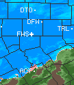
Radar indicates Denton could be seeing some good flurry action. Can anyone confirm it?
0 likes
The above post and any post by Ntxw is NOT an official forecast and should not be used as such. It is just the opinion of the poster and may or may not be backed by sound meteorological data. It is NOT endorsed by any professional institution including Storm2k. For official information, please refer to NWS products.
Help support Storm2K!
Help support Storm2K!
-
downsouthman1
- Category 2
- Posts: 706
- Age: 46
- Joined: Fri Jan 07, 2011 8:14 pm
- Location: Rowlett, TX
Re:
Ntxw wrote:Radar indicates Denton could be seeing some good flurry action. Can anyone confirm it?
What Radar are you observing? I don't see it on FWS: http://www.wunderground.com/radar/radbl ... ightning=0, nor surrounding Radars.
0 likes
Not a professional MET! My posts are merely speculation.
Re: Re:
downsouthman1 wrote:What Radar are you observing? I don't see it on FWS: http://www.wunderground.com/radar/radbl ... ightning=0, nor surrounding Radars.
http://radar.weather.gov/radar.php?rid=FWS&product=NCR&overlay=11101111&loop=yes
Probably isn't reaching the ground, but you never know. Maybe someone out there saw a stray flurry in the darker band!
0 likes
The above post and any post by Ntxw is NOT an official forecast and should not be used as such. It is just the opinion of the poster and may or may not be backed by sound meteorological data. It is NOT endorsed by any professional institution including Storm2k. For official information, please refer to NWS products.
Help support Storm2K!
Help support Storm2K!
-
WacoWx
- Category 2
- Posts: 692
- Joined: Mon Dec 28, 2009 4:14 pm
- Location: NOT Waco, TX ----> Dallas, TX
Re: Texas Winter 2010-2011
According to this radar, DFW is getting hammered right now. Waco, on the other hand, may see some flurry action later o...oh, wait, thats Ntxw's avatar.....again
Portastorm, I'm gonna go with the 'expect the worst and hope for the best' attitude as well. Sure do like hearing about an arctic plunge and a cut off low, just for discussion sake!
0 likes
-
downsouthman1
- Category 2
- Posts: 706
- Age: 46
- Joined: Fri Jan 07, 2011 8:14 pm
- Location: Rowlett, TX
Re: Re:
Ntxw wrote:downsouthman1 wrote:What Radar are you observing? I don't see it on FWS: http://www.wunderground.com/radar/radbl ... ightning=0, nor surrounding Radars.
http://radar.weather.gov/radar.php?rid=FWS&product=NCR&overlay=11101111&loop=yes
Probably isn't reaching the ground, but you never know. Maybe someone out there saw a stray flurry in the darker band!
O, I see. It's because you're looking at Composite & I'm looking at Base. I guess Composite probably is more applicable when the precip is occurring in the mid-levels as opposed to the surface layer.
0 likes
Not a professional MET! My posts are merely speculation.
-
HockeyTx82
- S2K Supporter
- Posts: 2790
- Joined: Tue Oct 27, 2009 11:17 am
- Location: Ponder, TX
Re:
Ntxw wrote:Radar indicates Denton could be seeing some good flurry action. Can anyone confirm it?
I just looked out the window. Nothing is falling; still some snow around and man is it cold. I would say this air mass has delivered on some levels. I don't think Denton has been above freezing since Sunday!!!!!!
0 likes
Don't hold me accountable for anything I post on this forum. Leave the real forecasting up to the professionals.
Location: Ponder, TX (all observation posts are this location unless otherwise noted)
Location: Ponder, TX (all observation posts are this location unless otherwise noted)
Re: Texas Winter 2010-2011
WacoWx wrote:According to this radar, DFW is getting hammered right now. Waco, on the other hand, may see some flurry action later o...oh, wait, thats Ntxw's avatar.....again
Portastorm, I'm gonna go with the 'expect the worst and hope for the best' attitude as well. Sure do like hearing about an arctic plunge and a cut off low, just for discussion sake!

I apologize for the torture but the this radar shows much of the same also! (oops for got it was Sunday's)
No seriously, you should keep an eye out for that stray flake today!
Last edited by Ntxw on Wed Jan 12, 2011 2:46 pm, edited 1 time in total.
0 likes
The above post and any post by Ntxw is NOT an official forecast and should not be used as such. It is just the opinion of the poster and may or may not be backed by sound meteorological data. It is NOT endorsed by any professional institution including Storm2k. For official information, please refer to NWS products.
Help support Storm2K!
Help support Storm2K!
Who is online
Users browsing this forum: No registered users and 79 guests