
TXZ118-133-021100-
/O.EXB.KFWD.WW.Y.0001.190102T0900Z-190102T1800Z/
Tarrant-Johnson-
Including the cities of Fort Worth, Arlington, Cleburne,
and Burleson
900 PM CST Tue Jan 1 2019
...WINTER WEATHER ADVISORY IN EFFECT FROM 3 AM TO NOON CST
WEDNESDAY...
* WHERE...Tarrant and Johnson Counties.
* WHAT...Freezing rain expected. Total ice accumulations of a
light glaze expected on bridges, overpasses, and fly-overs.
* ACCUMULATION...A trace to a couple hundredths of an inch of ice
are possible.
* WHEN...From 3 AM to noon CST Wednesday.
* ADDITIONAL DETAILS...Plan on slick conditions on bridges,
overpasses, and fly-overs. The hazardous conditions could impact
the morning commute.
Texas Winter 2018-2019
Moderator: S2k Moderators
Forum rules
 The posts in this forum are NOT official forecast and should not be used as such. They are just the opinion of the poster and may or may not be backed by sound meteorological data. They are NOT endorsed by any professional institution or STORM2K.

The posts in this forum are NOT official forecast and should not be used as such. They are just the opinion of the poster and may or may not be backed by sound meteorological data. They are NOT endorsed by any professional institution or STORM2K.
Re: Texas Winter 2018-2019
0 likes
-
Texas Snow

- S2K Supporter

- Posts: 817
- Joined: Mon Oct 19, 2015 12:06 pm
- Location: N. Dallas & Cedar Creek Lake
Re: Texas Winter 2018-2019
This provides interesting insight...
AFDFWD
Area Forecast Discussion
National Weather Service Fort Worth TX
859 PM CST Tue Jan 1 2019
.UPDATE...
The 00z FWD sounding shows a pretty substantial sub-freezing
layer just above the surface in the lowest 3000 feet with coldest
temps down to about -4C. The NAM forecasted this type of profile
and the other models are a bit warmer which means we are liking
the NAM output through Wednesday the best. The issue that we are
wrestling with is that if precipitation originates in this layer
it would be drizzle due to the very shallow region of lift below
the frontal inversion, and it would also be supercooled - meaning
that it will be more effective at coating elevated objects with a
glaze of ice if it`s substantial enough. We are within the time
range where we can slice the onion pretty thin and it appears that
temperatures near or just below freezing will occur in
northwestern and western Tarrant county and western Johnson county
where the terrain is just a little bit higher. The current wet
bulb temperatures (representing how cold actual temperatures could
fall via evaporational cooling) are already at 32F and expected
to fall another degree by sunrise in this area.
The numerous bridges and overpasses (and some of the flyovers
reach 100 feet above the surface where temps will be even cooler)
makes us a little more wary of the traffic impacts of even a
trace of icing could have. So we will be adding Tarrant and
Johnson counties to the winter weather advisory as we believe that
those commuting on the bridges and overpasses in the morning
should be wary of icy spots and probably need to adjust their
daily routine - whether that means just adding more time for their
commute or choosing a route that doesn`t involve a high bridge or
interchange.
Once the true rain reaches the area (that is forming higher up in
and a much warmer part of the atmosphere) we expect that surface
temperatures will warm above freezing. These rain drops will be
above freezing and would even serve to help melt any ice that did
collect. Thus the 2 county addition to the winter weather
advisory will only be from 3 am to noon. Plain old cold rain is
expected for the afternoon hours.
It must be stressed that we are talking about very light amounts
of icing and only on elevated surfaces, and essentially the
forecasted meteorological variables are hardly changed from the
previous forecast. What we`re trying to forecast here are the
impacts of those variables on society (weather is hard enough,
but impacts are another layer of uncertainty). Regardless we`ve
seen enough in the current data to make us concerned that the
weather could cause a disruption in parts of Tarrant and Johnson
counties. The remainder of the forecast remains unchanged.
TR.92
2 likes
"Don't let wishcastin get in the way of your forecastin"

-
SouthernMet

- Category 3

- Posts: 857
- Joined: Sun Aug 29, 2010 8:23 pm
- Location: fort worth, tx
Re: Texas Winter 2018-2019
rwfromkansas wrote:Tarrant added to advisory.
And Johnson county.
1 likes
Nothing that SouthernMet posts, is an official forecast,nor does it reflect views of STORM2K.. SouthernMet is just adding to the great discussions on STORM2K.. Refer to NWS for official forecasts.
-
orangeblood
- S2K Supporter
- Posts: 3895
- Joined: Tue Dec 15, 2009 6:14 pm
- Location: Fort Worth, TX
Re: Texas Winter 2018-2019
SouthernMet wrote:rwfromkansas wrote:Tarrant added to advisory.
And Johnson county.
I believe Tarrant County currently has a 3 in a row winter weather advisory/warning bust streak, hopefully that is broken this time around
3 likes
-
Captmorg70
- Tropical Storm

- Posts: 206
- Age: 38
- Joined: Mon Dec 18, 2017 12:07 am
- Location: Highland Village Tx
Re: Texas Winter 2018-2019
So the 00z RGEM wouldnt be great for Dallas Co, but that run has nice potential for the counties N and W of Dallas. It looks like the coldest model atm
0 likes
Location - Highland Village
-
Texas Snow
- S2K Supporter
- Posts: 817
- Joined: Mon Oct 19, 2015 12:06 pm
- Location: N. Dallas & Cedar Creek Lake
Re: Texas Winter 2018-2019
Looks like tropical tidbits is currently down, at least the mobile version.
0 likes
"Don't let wishcastin get in the way of your forecastin"

Re: Texas Winter 2018-2019
Texas Snow wrote:Looks like tropical tidbits is currently down, at least the mobile version.
Changed servers last night. Need to delete your old bookmark.
1 likes
-
HockeyTx82
- S2K Supporter
- Posts: 2774
- Joined: Tue Oct 27, 2009 11:17 am
- Location: Ponder, TX
Re: Texas Winter 2018-2019
Well folks. I'm off to bed. While I would love to stay up it's back to work tomorrow after the Christmas and New Year break. Perhaps a delayed start or one more day off. Keep the trends going and everyone stay warm and safe out there. Just remember how fortunate we are to have these models to look at and this forum to chat about it. There are those out there tonight just looking for a place to stay warm and dry. Happy New Year eveyone. Looking forward to one more year of S2K.
9 likes
Don't hold me accountable for anything I post on this forum. Leave the real forecasting up to the professionals.
Location: Ponder, TX (all observation posts are this location unless otherwise noted)
Location: Ponder, TX (all observation posts are this location unless otherwise noted)
-
orangeblood
- S2K Supporter
- Posts: 3895
- Joined: Tue Dec 15, 2009 6:14 pm
- Location: Fort Worth, TX
Re: Texas Winter 2018-2019
Captmorg70 wrote:So the 00z RGEM wouldnt be great for Dallas Co, but that run has nice potential for the counties N and W of Dallas. It looks like the coldest model atm
Yep, the RGEM has been very intriguing (and temp wise the most accurate) for several runs now
1 likes
-
hamburgerman7070
- Category 1

- Posts: 253
- Joined: Sat Dec 02, 2017 7:39 pm
- Location: Jonesboro ar
Re: Texas Winter 2018-2019
Happy New year everyone. This question is mainly for Ntxw or Bubba Hotep. The mjo looks to be on the move to different phases and we had the major SSW took effect earlier today. I want to know how long before we know if we can get into a colder pattern based on what i mentioned? Just been hearing alot about it lately.
0 likes
-
Ralph's Weather
- S2K Supporter
- Posts: 3371
- Age: 38
- Joined: Fri Dec 13, 2013 11:55 am
- Location: Lindale, TX
- Contact:
Re: Texas Winter 2018-2019
orangeblood wrote:Captmorg70 wrote:So the 00z RGEM wouldnt be great for Dallas Co, but that run has nice potential for the counties N and W of Dallas. It looks like the coldest model atm
Yep, the RGEM has been very intriguing (and temp wise the most accurate) for several runs now
These meso scale models sure can be helpful in situations like this. They can lead you astray if they are not matching reality but in a situation like this they are, esp the RGEM.
0 likes
Follow on Facebook at Ralph's Weather.
-
Ralph's Weather
- S2K Supporter
- Posts: 3371
- Age: 38
- Joined: Fri Dec 13, 2013 11:55 am
- Location: Lindale, TX
- Contact:
Re: Texas Winter 2018-2019
For me in E TX I am very interested in what the NAM and RGEM say tomorrow about the snow potential under the upper low core. Hoping to see the low track a bit S of I-20 as I am right on I-20 NW of Tyler. Before that though I have another 2 or 3 inches of rain coming so I expect many back roads and even some major roads across E TX to flood. Ready for an interesting set of commutes over these next few days with various weather threats on tap.
0 likes
Follow on Facebook at Ralph's Weather.
-
orangeblood
- S2K Supporter
- Posts: 3895
- Joined: Tue Dec 15, 2009 6:14 pm
- Location: Fort Worth, TX
Re: Texas Winter 2018-2019
hamburgerman7070 wrote:Happy New year everyone. This question is mainly for Ntxw or Bubba Hotep. The mjo looks to be on the move to different phases and we had the major SSW took effect earlier today. I want to know how long before we know if we can get into a colder pattern based on what i mentioned? Just been hearing alot about it lately.
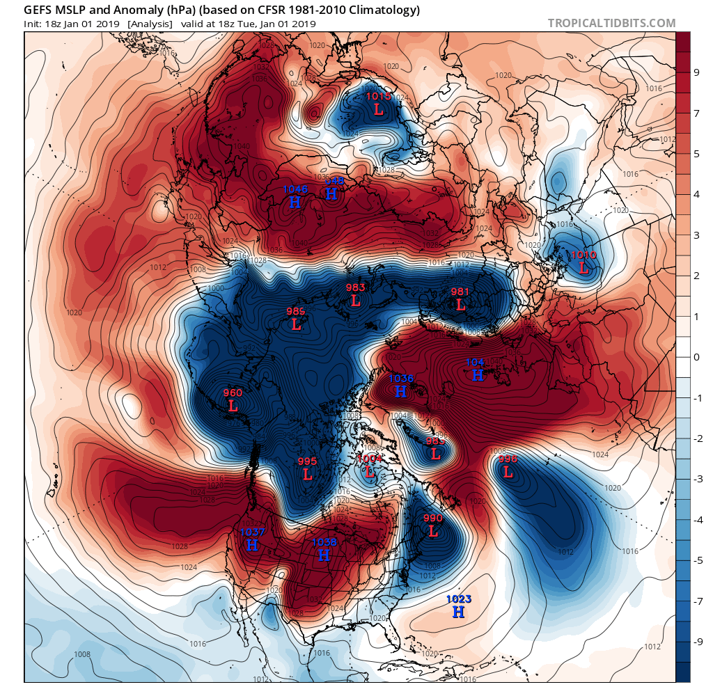
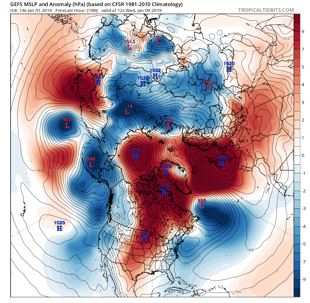
If you want a cold pattern, this is exactly what you want to see on the long range ens....that could become a brutally cold pattern

0 likes
-
rwfromkansas
- Category 5

- Posts: 3010
- Joined: Sat Aug 27, 2005 12:47 am
- Location: North Fort Worth
Re: Texas Winter 2018-2019
Temp drop stalled at 34.3 in north FW but freezing very close. Wet bulb around 30-31, so hopefully it will drop to full potential once deeper night sets in.
1 likes
-
Texas Snowman

- Storm2k Moderator

- Posts: 6197
- Joined: Fri Jan 25, 2008 11:29 am
- Location: Denison, Texas
Re: Texas Winter 2018-2019
Happy New Year’s everyone!!!!!!
5 likes
The above post and any post by Texas Snowman is NOT an official forecast and should not be used as such. It is just the opinion of the poster and may or may not be backed by sound meteorological data. It is NOT endorsed by any professional institution including storm2k.org. For official information, please refer to NWS products.

Re: Texas Winter 2018-2019
Texas Snowman wrote:Happy New Year’s everyone!!!!!!
Happy New Year! Just need some snow and Texas to finish off Georgia to make it a great start ..
1 likes

Re: Texas Winter 2018-2019
hamburgerman7070 wrote:Happy New year everyone. This question is mainly for Ntxw or Bubba Hotep. The mjo looks to be on the move to different phases and we had the major SSW took effect earlier today. I want to know how long before we know if we can get into a colder pattern based on what i mentioned? Just been hearing alot about it lately.
The SSW is a top->down event (vs bottom-up) thus why the lag between the NAM (not the model but the oscillation) shifts. The SSW is still occurring and it's evident the NAO will feel its grip first. Ignoring the Pacific for a moment, which is implicated by the MJO for another discussion, The AO will reverse course not long after. Dispersion of cold air into the mid latitudes is probable if not likely not long from now.
The reversal of MSLP in the North Atlantic and Arctic regions is a signal the SSW is taking a grip.
With higher mslp gearing towards North America vs Eurasia maybe we will (finally) be the benefactor of it. The past several years the SSW events have mainly generated a Barents/Kara ridge that drove higher mslp into Eurasia.
2 likes
The above post and any post by Ntxw is NOT an official forecast and should not be used as such. It is just the opinion of the poster and may or may not be backed by sound meteorological data. It is NOT endorsed by any professional institution including Storm2k. For official information, please refer to NWS products.
Help support Storm2K!
-
weatherdude1108
- Category 5
- Posts: 4228
- Joined: Tue Dec 13, 2011 1:04 pm
- Location: Northwest Austin/Cedar Park, TX
Re: Texas Winter 2018-2019
HAPPY NEW YEAR all! Hope everyone has a great year, and I hope to see snow at some point.


2 likes
The preceding post is NOT an official forecast, and should not be used as such. It is only the opinion of the poster and may or may not be backed by sound meteorological data. It is NOT endorsed by any professional institution including storm2k.org. For Official Information please refer to the NHC and NWS products.
-
cctxhurricanewatcher

- Category 5
- Posts: 1206
- Joined: Sun Sep 12, 2004 8:53 pm
- Location: Corpus Christi, Texas
-
orangeblood
- S2K Supporter
- Posts: 3895
- Joined: Tue Dec 15, 2009 6:14 pm
- Location: Fort Worth, TX
Re: Texas Winter 2018-2019
cctxhurricanewatcher wrote:Happy New year and what a great win for the Horns!
Yes it was...Hook Em'!!
Next system in the chamber just popped up....FV3 has another system for us to track for next weekend. Hopefully, the Euro latches on as well!

3 likes
Who is online
Users browsing this forum: cstrunk, Google [Bot] and 96 guests