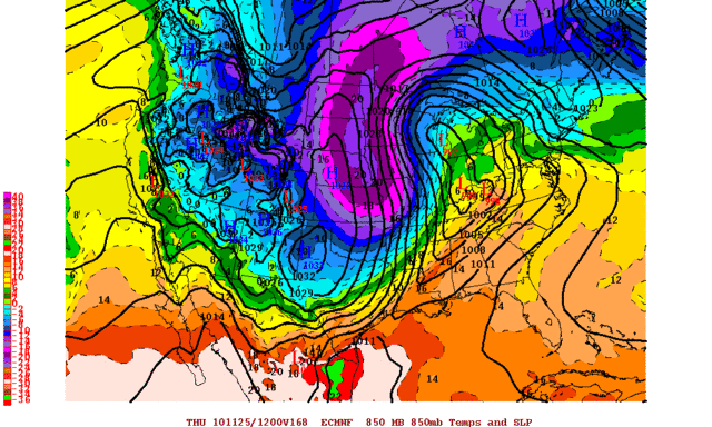
I will be in central Missouri for Thanksgiving day, and if this scenario proves correct then 850mb temperatures over my location will reach -14 to -16C or colder! I will definitely be bringing the heavy coat.. lol

Moderator: S2k Moderators
 The posts in this forum are NOT official forecast and should not be used as such. They are just the opinion of the poster and may or may not be backed by sound meteorological data. They are NOT endorsed by any professional institution or STORM2K.


In general, 850mb temperatures will be colder than the surface during the daylight hours and warmer than the surface during the nighttime hours. This is based on an idealized situation though; which features a run-of-the-mill sunny, not too windy day followed by a clear, light wind night. During the daylight hours, incoming solar radiation heats the surface much more quickly than the upper levels causing warmer temperatures, and during the nighttime hours, outgoing long wave radiation has the opposite effect; cooling the surface much more quickly.fogbreath wrote:Never had to worry much about really cold air being in the SF Bay Area, but now I've got some regularly scheduled travel going into typically colder regions of the US going now, so I've been following this thread with interest lately.
Is there a standard guideline how the 850 mb plot temps translate in terms of what the temperature would be closer to sea level?


SUB-ZERO ARCTIC AIR HAS ALREADY SLIPPED SOUTH OF THE CANADIAN
BORDER...BUT THE AIR MASS OF INTEREST REMAINS IN NORTHERN CANADA.
SITE ON ELLESMERE ISLAND IS CURRENTLY AT -35F. THIS BITTER COLD
WILL SPILL SOUTH INTO THE PRAIRIE PROVINCES EARLY NEXT WEEK.
LITTLE CHANGE TO FROPA TIMING IN NORTH TEXAS WEDNESDAY. RATHER
UNCHARACTERISTICALLY...GFS REMAINS AMONG THE FASTEST SOLUTIONS.
SHALLOW ARCTIC FRONTS TYPICALLY ARRIVE MORE QUICKLY THAN THE
VERTICAL RESOLUTION OF THE GFS CAN PREDICT...BUT LOOKING AT THE
LIKELY EVOLUTION OF THE SURFACE FRONT EARLY NEXT WEEK...ARCTIC
AIR WOULD BE HARD PRESSED TO ARRIVE MUCH SOONER THAN CURRENT
FORECAST. PATTERN SHOULD ASSURE THAT COLDEST AIR IMPACTS GREAT
LAKES AND NORTHEAST STATES...BUT THANKSGIVING WILL BE A CHILLY ONE
FOR NORTH TEXAS.


wall_cloud wrote:These are my thoughts on what I'm looking at this morning. If its "common knowledge" to you, please disregard. Its mainly meant for the novice forecasters that want to know what goes on inside the head of a met on a midnight shift! Keep in mind that these thoughts are my own and do not necessarily reflect those of NOAA/NWS (or the individual responsible for that portion of the forecast).
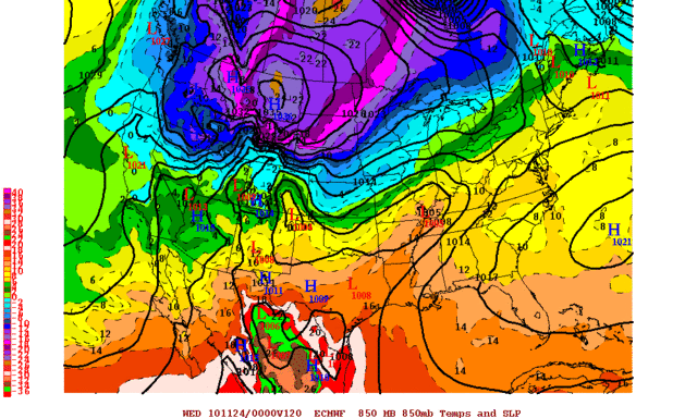
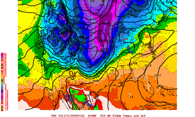
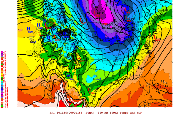
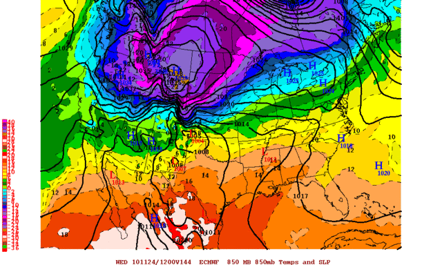
The medium range models are coming into better agreement on the timing of this system although the 00z ECMWF is again the cooler of the two. This ECMWF run shows a much stronger (and well timed) vort lobe rounding the base of the trof is it swings into the Plains. The GFS shows a similar wave but it is delayed by about 24 hrs. The 00z GEM appears to be very much in line with the ECMWF. The GFS ensemble suite still offers a wide range of solutions and is toward the bottom of my trust ladder at this time so I'm going to focus more on the ECMWF/GEM solutions.
The strong southwest flow aloft ahead of the main trof will support strong lee cyclogenesis. This should bump the southwest winds up across west TX early in the week with highs around 80 in my neck of the woods. However, it looks like a wave train of shortwaves will move out of the southwest almost daily beginning Monday. This will eject the lee cyclone off to the east, keeping the primary baroclinic zone waffling over the central plains. By Tuesday, the cold air dislodges and begins its trek south, aided by another surface low moving out into the plains.
*Now for what I was waiting to see (hoping the ECMWF pans out)* The main trof slowly moves east with the surface low preceding. As the strong vort lobe rotates around the southwest periphery of the main trof, surface cyclogenesis is induced over the southern plains. I think this low (in addition to the mass aspect) will be the main factor in whether or not this cold air blasts all the way through TX. The GFS being out of phases does not have time to reinforce the initial push and really slows the front as it approaches the gulf coast while the ECMWF brings north winds to our friends on the Yucatan by Friday. Look for this shortwave/vort lobe rounding the main trof in the coming days. It will be key.
I wouldn't trust any MOS out this far even if the model solution looked good. Take the GFS MOS. We are looking at days 6-7 for west central TX (SJT area). At these stages, there is way too much climatology built into the model to account for a strong fropa. It is spouting off a max of 53 for Thursday and we could easily be 10 degrees cooler.


kb75007 wrote:When is this cold air expected to arrive? I've noticed some of you on here are saying maybe highs in the 30's for Dallas on thursday or friday but weather.com is saying high 50 and sunny on Thanksgiving. Also, the news is saying high 47. No one really seems to have a grip on what is going to happen. Is this front going to have moisture coming in behind it at all? Or does it look like just sunny or cloudy skies? Whats the latest on this front?! Im hoping for
The following post is NOT an official forecast and should not be used as such. It is just the opinion of the poster and may or may not be backed by sound meteorological data. It is NOT endorsed by any professional institution including storm2k.org. For official information, please refer to NWS products.
Ntxw wrote:kb75007 wrote:When is this cold air expected to arrive? I've noticed some of you on here are saying maybe highs in the 30's for Dallas on thursday or friday but weather.com is saying high 50 and sunny on Thanksgiving. Also, the news is saying high 47. No one really seems to have a grip on what is going to happen. Is this front going to have moisture coming in behind it at all? Or does it look like just sunny or cloudy skies? Whats the latest on this front?! Im hoping for
I never use the weather channel anymore. Their data is simply straight out of the models without much human input and in depth analysis. The NWS is the best choice to go a few days out.
It will get cold in Dallas Weds-Friday. Can't pinpoint the exact timing (looks like Weds currently but will it be morning, midday or evening is yet to be seen) because dense air masses can travel faster than what models depict typically. 30s-40s for highs on Thurs is a real possibility.The following post is NOT an official forecast and should not be used as such. It is just the opinion of the poster and may or may not be backed by sound meteorological data. It is NOT endorsed by any professional institution including storm2k.org. For official information, please refer to NWS products.
THERE WERE HINTS IN THE MODELS YESTERDAY THAT THE MAIN UPPER
TROUGH AXIS WOULD HANG BACK AND NOT CLEAR THE AREA UNTIL THURSDAY
EVENING. ALL OF THE GUIDANCE CONTINUES TO SEEMINGLY TREND IN THIS
DIRECTION TODAY...WITH THE UPPER TROUGH AXIS LOOKING SHARPER AND
MORE POTENT. SOME OF THE GEM AND GFS MODEL ENSEMBLES ACTUALLY
CLOSE OFF A LOW AT THE BASE OF THE TROUGH OVER THE DESERT SW. THE
INTENSIFICATION OF THE TROUGH AXIS APPEARS TO BE RELATED TO A
TROPOPAUSE FOLDING EVENT AS A STRONG RIDGE OVER THE WESTERN
PACIFIC PUSHES ONSHORE. STRATOSPHERIC AIR IS HIGH IN POTENTIAL
VORTICITY...AND DETERMINING JUST HOW MUCH OF THIS AIR DESCENDS IS
IMPOSSIBLE AT THIS POINT. HOWEVER THE POSSIBILITY EXISTS THAT THE
LAGGING DISTURBANCE WILL INDUCE ENOUGH OF A DYNAMIC RESPONSE TO
RESULT IN ISENTROPIC LIFT OVER THE AREA THURSDAY. THE LOW LEVEL
AIR MASS WILL BE FAIRLY DRY...BUT SATURATION ALOFT AND SOME
ELEVATED INSTABILITY ARE INDICATED IN THE VARIOUS SOLUTIONS. WILL
SHOW A LOW CHANCE OF A VERY COLD RAIN THURSDAY OVER THE CENTRAL
AND SOUTHEAST HALF OF THE AREA.


srainhoutx wrote::uarrow:
It certainly can not be ruled out, IMO. The 'wrinkle' started showing itself with the 00Z yesterday runs and with todays output, you can almost sense a move toward biting on a stronger/slower progression of the Upper Air feature coming through Thanksgiving Day/night. I suspect there will be some model watching in the days ahead.
Users browsing this forum: No registered users and 437 guests