IF THE GFS IS RIGHT THE WEATHER WILL BE VERY
INTERESTING IN THE LOWER MS VALLEY FRI WITH A POSSIBLE SIGNIFICANT
WINTER SYSTEM ON OUR HANDS.
Thats from the Area Forecast Discussion for the Jackson WFO's service area........quite interesting. No cause for alarm but wouldn't hurt to watch and see what this might/might not do. Local mets all saying to watch out for this later this week (which it is VERY VERY rare for all 3 to say the same thing)
Winter Weather in the deep south thread
Moderator: S2k Moderators
Forum rules
 The posts in this forum are NOT official forecast and should not be used as such. They are just the opinion of the poster and may or may not be backed by sound meteorological data. They are NOT endorsed by any professional institution or STORM2K.

The posts in this forum are NOT official forecast and should not be used as such. They are just the opinion of the poster and may or may not be backed by sound meteorological data. They are NOT endorsed by any professional institution or STORM2K.
-
MississippiHurricane

- ChatStaff

- Posts: 648
- Age: 41
- Joined: Sat Jul 16, 2005 12:20 am
- Location: Hanover, Maryland
- Contact:
-
Brent
- S2K Supporter

- Posts: 38714
- Age: 37
- Joined: Sun May 16, 2004 10:30 pm
- Location: Tulsa Oklahoma
- Contact:
Re: Snow in the deep south Mid January?
From NWS BMX:
WEAK RIDGING BUILDS INTO THE SOUTHEAST ON WEDNESDAY...TURNING LOW
LEVEL FLOW SOUTHERLY. A TROUGH MOVING OUT OF PLAINS WILL PROMPT
SURFACE CYCLOGENESIS IN THE NORTHWEST GULF OF MEXICO. AS THE LOW
MOVES NORTHEASTWARD AND ACROSS THE BIG BEND REGION OF
FLORIDA...MOISTURE AND RAIN WILL BEGIN TO SPREAD NORTHWARD INTO
CENTRAL ALABAMA WEDNESDAY. MODELS BEGIN TO DIFFER AT THIS POINT WITH
TIMING OF THE UPPER LEVEL TROUGH...WITH THE OPERATIONAL GFS BEING
THE OUTLIER AND QUICKER THAN THE REST OF THE MEMBERS. TOOK A BIT
MORE OF A ECMWF SOLUTION...AND KEPT MENTION OF PRECIPITATION IN THE
FORECAST THROUGH FRIDAY NIGHT.
THIS SETUP OF OVERRUNNING FROM A GULF LOW AND ARCTIC AIR FLOW INTO
THE REGION IS THE BEST SCENARIO FOR LOCAL SNOWFALL. FOR THIS
SITUATION...THE LOW LOOKS TO TRACK A BIT TO FAR TO THE EAST AND THE
AIR IN PLACE IS NOT QUITE COLD ENOUGH FOR WIDESPREAD SNOW SHOWERS.
WITH THAT SAID...FLURRIES WILL BE POSSIBLE THURSDAY NIGHT AND EARLY
FRIDAY MORNING AS TEMPERATURES DROP BELOW FREEZING. AS THE UPPER
LEVEL TROUGH AXIS SWINGS THROUGH FRIDAY NIGHT...THERE WILL BE A
SLIGHT CHANCE OF FLURRIES ACROSS THE NORTHERN TWO-THIRDS OF THE
FORECAST AREA...AND DRIZZLE ELSEWHERE. MOST OF THE PRECIPITATION
WILL REMAIN LIQUID.
and from FFC:
.LONG TERM /TUESDAY THROUGH SATURDAY/...
MAIN CONCERN FOR THE LONG TERM CONTINUES TO BE THE POTENTIALLY
SIGNIFICANT SYSTEM THAT WILL IMPACT OUR AREA THURSDAY. 12Z MODELS
HAVE TRENDED A LITTLE SLOWER WITH THE SYSTEM...BRINGING IT IN A
LITTLE LATER IN THE DAY ON THURSDAY THAN IN PREVIOUS RUNS. THERE
ARE DIFFERENCES BETWEEN THE EXTENDED MODELS...BUT HAVE LEANED
TOWARDS A GFS SOLUTION AT THIS POINT. GIVEN THE SITE OF
CYCLOGENESIS IN THE CENTRAL GULF OF MEXICO...THIS SYSTEM WILL HAVE
THE POTENTIAL TO BRING SOME WINTER WEATHER INTO THE AREA...HOWEVER
THIS FAR OUT IT IS STILL TO EARLY TO TELL WHAT EXACTLY WILL
HAPPEN...SO HAVE CONTINUED THE MENTION OF A RAIN/SNOW MIX ONLY IN
THE NORTHEAST MOUNTAINS. LOOKS LIKE THIS SYSTEM COULD BRING HEAVY
SNOW...FREEZING RAIN...OR JUST RAIN FOR NORTH GEORGIA...ESPECIALLY
IN THE NORTHEAST MOUNTAINS. ALL AREAS SOUTH OF ATLANTA AND ATHENS
WILL LIKELY SEE ALL RAIN...WITH SOME SIGNIFICANT AMOUNTS CERTAINLY
POSSIBLE. WHAT EXACTLY FALLS WILL DEPEND ON HOW FAR SOUTH THIS
SYSTEM TRACKS...WILL SEE HOW LATER RUNS HANDLE THINGS TO SEE IF
ANY CONSISTENCY CAN COME ABOUT BEFORE BUYING OFF ON ANY
SIGNIFICANT WINTER WEATHER.
GFS at Midnight Wednesday Night, looks like a very close call.

The big blizzard projected for Friday is a much smaller event now(and has been since this morning apparently, I've been gone all day).
WEAK RIDGING BUILDS INTO THE SOUTHEAST ON WEDNESDAY...TURNING LOW
LEVEL FLOW SOUTHERLY. A TROUGH MOVING OUT OF PLAINS WILL PROMPT
SURFACE CYCLOGENESIS IN THE NORTHWEST GULF OF MEXICO. AS THE LOW
MOVES NORTHEASTWARD AND ACROSS THE BIG BEND REGION OF
FLORIDA...MOISTURE AND RAIN WILL BEGIN TO SPREAD NORTHWARD INTO
CENTRAL ALABAMA WEDNESDAY. MODELS BEGIN TO DIFFER AT THIS POINT WITH
TIMING OF THE UPPER LEVEL TROUGH...WITH THE OPERATIONAL GFS BEING
THE OUTLIER AND QUICKER THAN THE REST OF THE MEMBERS. TOOK A BIT
MORE OF A ECMWF SOLUTION...AND KEPT MENTION OF PRECIPITATION IN THE
FORECAST THROUGH FRIDAY NIGHT.
THIS SETUP OF OVERRUNNING FROM A GULF LOW AND ARCTIC AIR FLOW INTO
THE REGION IS THE BEST SCENARIO FOR LOCAL SNOWFALL. FOR THIS
SITUATION...THE LOW LOOKS TO TRACK A BIT TO FAR TO THE EAST AND THE
AIR IN PLACE IS NOT QUITE COLD ENOUGH FOR WIDESPREAD SNOW SHOWERS.
WITH THAT SAID...FLURRIES WILL BE POSSIBLE THURSDAY NIGHT AND EARLY
FRIDAY MORNING AS TEMPERATURES DROP BELOW FREEZING. AS THE UPPER
LEVEL TROUGH AXIS SWINGS THROUGH FRIDAY NIGHT...THERE WILL BE A
SLIGHT CHANCE OF FLURRIES ACROSS THE NORTHERN TWO-THIRDS OF THE
FORECAST AREA...AND DRIZZLE ELSEWHERE. MOST OF THE PRECIPITATION
WILL REMAIN LIQUID.
and from FFC:
.LONG TERM /TUESDAY THROUGH SATURDAY/...
MAIN CONCERN FOR THE LONG TERM CONTINUES TO BE THE POTENTIALLY
SIGNIFICANT SYSTEM THAT WILL IMPACT OUR AREA THURSDAY. 12Z MODELS
HAVE TRENDED A LITTLE SLOWER WITH THE SYSTEM...BRINGING IT IN A
LITTLE LATER IN THE DAY ON THURSDAY THAN IN PREVIOUS RUNS. THERE
ARE DIFFERENCES BETWEEN THE EXTENDED MODELS...BUT HAVE LEANED
TOWARDS A GFS SOLUTION AT THIS POINT. GIVEN THE SITE OF
CYCLOGENESIS IN THE CENTRAL GULF OF MEXICO...THIS SYSTEM WILL HAVE
THE POTENTIAL TO BRING SOME WINTER WEATHER INTO THE AREA...HOWEVER
THIS FAR OUT IT IS STILL TO EARLY TO TELL WHAT EXACTLY WILL
HAPPEN...SO HAVE CONTINUED THE MENTION OF A RAIN/SNOW MIX ONLY IN
THE NORTHEAST MOUNTAINS. LOOKS LIKE THIS SYSTEM COULD BRING HEAVY
SNOW...FREEZING RAIN...OR JUST RAIN FOR NORTH GEORGIA...ESPECIALLY
IN THE NORTHEAST MOUNTAINS. ALL AREAS SOUTH OF ATLANTA AND ATHENS
WILL LIKELY SEE ALL RAIN...WITH SOME SIGNIFICANT AMOUNTS CERTAINLY
POSSIBLE. WHAT EXACTLY FALLS WILL DEPEND ON HOW FAR SOUTH THIS
SYSTEM TRACKS...WILL SEE HOW LATER RUNS HANDLE THINGS TO SEE IF
ANY CONSISTENCY CAN COME ABOUT BEFORE BUYING OFF ON ANY
SIGNIFICANT WINTER WEATHER.
GFS at Midnight Wednesday Night, looks like a very close call.
The big blizzard projected for Friday is a much smaller event now(and has been since this morning apparently, I've been gone all day).
0 likes
Re: Snow in the deep south Mid January?
Please keep us posted... I just moved to GA from Florida and we're not use to snow. We live on a mountain and the roads are quite hilly and treacherous. I just heard on the local news that we might get snow either Thurs. or Friday... Thanks for any information you can provide me...
0 likes
-
Ivanhater

- Storm2k Moderator

- Posts: 11221
- Age: 39
- Joined: Fri Jul 01, 2005 8:25 am
- Location: Pensacola
Re: Snow in the deep south Mid January?
Cutting it real close for heavy wintry precip for the gulfcoast on 18z..and only 5 days away!

0 likes
-
JonathanBelles
- Professional-Met

- Posts: 11430
- Age: 35
- Joined: Sat Dec 24, 2005 9:00 pm
- Location: School: Florida State University (Tallahassee, FL) Home: St. Petersburg, Florida
- Contact:
http://www.nco.ncep.noaa.gov/pmb/nwprod ... n_162l.gif
This is interesting for me. Close call, only one frame though.
This is interesting for me. Close call, only one frame though.
0 likes
Re: Snow in the deep south Mid January?
to ivanhater or anyone on this blog,
i'm new to this site and don't know how to read the maps nor have any clue as to what the 18z is? is this system going to have any effect on north georgia? thanks!
i'm new to this site and don't know how to read the maps nor have any clue as to what the 18z is? is this system going to have any effect on north georgia? thanks!
0 likes
-
Brent
- S2K Supporter
- Posts: 38714
- Age: 37
- Joined: Sun May 16, 2004 10:30 pm
- Location: Tulsa Oklahoma
- Contact:
Re: Snow in the deep south Mid January?
Cristina wrote:to ivanhater or anyone on this blog,
i'm new to this site and don't know how to read the maps nor have any clue as to what the 18z is? is this system going to have any effect on north georgia? thanks!
Right now the only storm that looks to affect North Georgia(in the next week) is on Wednesday/Thursday and it appears to primarily be a rain event, possibly a wintry mix to start, but not looking like a big deal.
Subject to change however.
0 likes
Re: Snow in the deep south Mid January?
Thank you very much... some of our local stations are calling it a wintry mix on Thurs and possible snow on Thurs after 11 PM. Please keep us posted if you feel conditions will deteriorate. Sometimes our local stations tell us is going to snow when it doesn't and vice versa... very confusing to us ex-Floridians! We're familiar w/hurricanes, not snow.... thanks again!
Last edited by Cristina on Sun Jan 13, 2008 7:17 pm, edited 1 time in total.
0 likes
-
Brent
- S2K Supporter
- Posts: 38714
- Age: 37
- Joined: Sun May 16, 2004 10:30 pm
- Location: Tulsa Oklahoma
- Contact:
Re: Snow in the deep south Mid January?
Cristina wrote:Thank you very much... some of our local stations are calling it a wintry mix on Thurs and possible snow on Thurs after 11 PM. Please keep us posted if you feel conditions will deteriorate. Sometimes our local stations tell us is going to snow when it doesn't and vice versa... very confusing! thanks again!
Will do.
Forecasting snow in this area is EXTREMELY difficult. I've seen snow events not pan out even at the last minute(as in the same day), and then I've seen totally unexpected snow events that no one expected.
0 likes
-
Brent
- S2K Supporter
- Posts: 38714
- Age: 37
- Joined: Sun May 16, 2004 10:30 pm
- Location: Tulsa Oklahoma
- Contact:
Re: Snow in the deep south Mid January?
Well, well, well! 
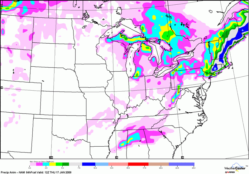
The blue is around 2 inches, the yellow is 3-4 inches. The purple is 1 to 2 inches.
The blue is around 2 inches, the yellow is 3-4 inches. The purple is 1 to 2 inches.
0 likes
-
Lowpressure

- S2K Supporter
- Posts: 2032
- Age: 58
- Joined: Sun Sep 14, 2003 9:17 am
- Location: Charlotte, North Carolina
Re: Snow in the deep south Mid January?
I am watching it here in Charlotte as well Brent. Trend has been colder lately reversing a warming trend predicted earlier. Lets hope the trend is our friend. Our window of interest will be Wednesday night thru Thursday night. High Thursday currently forecasted at 38.
0 likes
Re: Snow in the deep south Mid January?
I am hoping that it will trend colder here in central SC as well. However, right now it appears as if it will be too warm for winter precip. It will take a big reversal in the temps to give us hope..............
0 likes
-
Lowpressure
- S2K Supporter
- Posts: 2032
- Age: 58
- Joined: Sun Sep 14, 2003 9:17 am
- Location: Charlotte, North Carolina
Re: Snow in the deep south Mid January?
We seem to be marginal here with 31 WED PM- 38 THURS-32 THURSDAY PM. They are going with 30%-70%-30%. So it appears as though something will fall from the sky, probably one of those starts off as snow then turns to cold rain for the rest of the event deals. Afternoon runs will be interesting, hopefully they trend colder for us- you too Brent.
0 likes
-
VoodooCadillac
- Tropical Depression

- Posts: 82
- Joined: Wed Dec 14, 2005 8:56 pm
- Location: Fort Collins, Colorado
Re: Snow in the deep south Mid January?
This is the classic good set-up for the Central and Southern mountains of WNC, instead of the Northern and Tennessee border mountain areas that do so well in the NW CAA events. Look for a good swath of snow from Highlands > Cashiers > Rosman > Brevard > Hendersonville/Saluda > Black Mountain - with a little less in Asheville. It looks like a cold week ahead - especially this weekend (1/19, 1/20).
0 likes
-
Brent
- S2K Supporter
- Posts: 38714
- Age: 37
- Joined: Sun May 16, 2004 10:30 pm
- Location: Tulsa Oklahoma
- Contact:
Re: Snow in the deep south Mid January?
NEXT! 
Wednesday Night...A chance of rain early in the evening...then snow likely between 9 pm and 2 am. Rain in the late evening and overnight. No snow accumulation.

Wednesday Night...A chance of rain early in the evening...then snow likely between 9 pm and 2 am. Rain in the late evening and overnight. No snow accumulation.
0 likes
-
southerngale

- Retired Staff

- Posts: 27418
- Joined: Thu Oct 10, 2002 1:27 am
- Location: Southeast Texas (Beaumont area)
Re: Snow in the deep south Mid January?
Brent wrote:NEXT!
Wednesday Night...A chance of rain early in the evening...then snow likely between 9 pm and 2 am. Rain in the late evening and overnight. No snow accumulation.
It's not like you're sleeping at that time. You just might get more than they predict. I like your forecast better than mine:
Tuesday Night: Rain likely, mainly after midnight. Cloudy, with a low around 43. South wind 5 to 10 mph becoming east. Chance of precipitation is 60%.
Wednesday: Periods of rain. High near 48. North wind between 5 and 10 mph. Chance of precipitation is 80%.
Wednesday Night: A 30 percent chance of rain, mainly before midnight. Mostly cloudy, with a low around 39. North wind around 5 mph
0 likes
-
Brent
- S2K Supporter
- Posts: 38714
- Age: 37
- Joined: Sun May 16, 2004 10:30 pm
- Location: Tulsa Oklahoma
- Contact:
Re: Snow in the deep south Mid January?
southerngale wrote:Brent wrote:NEXT!
Wednesday Night...A chance of rain early in the evening...then snow likely between 9 pm and 2 am. Rain in the late evening and overnight. No snow accumulation.
It's not like you're sleeping at that time. You just might get more than they predict. I like your forecast better than mine:
Tuesday Night: Rain likely, mainly after midnight. Cloudy, with a low around 43. South wind 5 to 10 mph becoming east. Chance of precipitation is 60%.
Wednesday: Periods of rain. High near 48. North wind between 5 and 10 mph. Chance of precipitation is 80%.
Wednesday Night: A 30 percent chance of rain, mainly before midnight. Mostly cloudy, with a low around 39. North wind around 5 mph
True...
I'm actually thinking if we get anything frozen, it'll be sleet or maybe freezing rain(which is what the local mets are mostly playing up now), and I'd just rather have rain than that. I'm really not convinced there will be even a brief period of snow.
0 likes
Re: Snow in the deep south Mid January?
Brent wrote:NEXT!
Wednesday Night...A chance of rain early in the evening...then snow likely between 9 pm and 2 am. Rain in the late evening and overnight. No snow accumulation.
Is this prediction for NC? thanks!
0 likes
-
Lowpressure
- S2K Supporter
- Posts: 2032
- Age: 58
- Joined: Sun Sep 14, 2003 9:17 am
- Location: Charlotte, North Carolina
Re: Snow in the deep south Mid January?
Cristina wrote:Brent wrote:NEXT!
Wednesday Night...A chance of rain early in the evening...then snow likely between 9 pm and 2 am. Rain in the late evening and overnight. No snow accumulation.
Is this prediction for NC? thanks!
No, I think Brent lives in Northern Alabama.
0 likes
-
Lowpressure
- S2K Supporter
- Posts: 2032
- Age: 58
- Joined: Sun Sep 14, 2003 9:17 am
- Location: Charlotte, North Carolina
Re: Snow in the deep south Mid January?
This is for the Charlotte area- out of Greer, SC.
LONG TERM /WEDNESDAY NIGHT THROUGH MONDAY/...
AS OF 300 PM MONDAY...LATEST RUNS OF THE OP NAM/GFS/ECMWF IN GOOD
AGREEMENT WITH RESPECT TO FCST LOW POSITION OVER THE NORTHERN GULF
AT 00 UTC THU...THEN TRACKING NE TOWARD THE FLORIDA PANHANDLE INTO
THU MORNING. THERE CONTINUES TO BE TIMING DIFFERENCES WITH RESPECT
TO HOW FAST INCREASED LAYER RH OVERSPREADS THE CWFA...AND WILL
BASE THE WED NITE POPS ON THE 14/15 UTC SREF...WHICH WARRANTS AN
INCREASE TO LIKELY...ESPECIALLY ACRS THE SW CWFA. TAKING A BLEND OF
MODEL PARTIAL THICKNESS VALUES...YIELDS MOSTLY SNOW FOR THE P-TYPE
DURING THE NIGHT...WITH MIXED PCPN BECOMING INCREASINGLY PROBABLE
TOWARD 12 UTC STARTING THE SOUTHEAST PIEDMONT. THRU 12 UTC
THU...WOULD NOT BE SURPRISED TO SEE ADVISORY LVL SNOW ACCUMS ACRS
THE MTNS...NE GA AND THE WESTERN UPSTATE.
SFC LOW SHOULD GRADUALLY DEEPEN AS IT TRACKS NE NEAR THE CAROLINA
COAST THRU THURSDAY. THERE SEEMS TO BE SOME TIMING CONCERNS HOW JUST
HOW FAST THE LOW TRACKS AND HOW MUCH SFC WEDGE WILL WEAKEN
THROUGHOUT THE DAY. IT CERTAINLY LOOKS LIKE THE MORNING HOURS WOULD
STAND THE GREATEST PCPN CHANCE AND WILL BUMP UP TO CATEGORICAL THRU
NOON AND THEN TAPER TO CHANCE BY LATE AFTERNOON WITH DRY SLOT MOVING
UP FROM THE SW. SLOW WARMING IS LIKELY ALL DAY FROM THE SFC TO 700
MB...BUT JUST HOW QUICKLY THIS OCCURS REMAINS UNCERTAIN. FOR
NOW...WILL TRANSITION FROM FROZEN TO LIQUID/FREEZING FROM THE SOUTH
THROUGHOUT THE MORNING WITH DIMINISHING RAIN AND MIXED PCPN AS THE
AFTERNOON WEARS ON...WITH SFC TEMPS RISING TO THE MIDDLE 30S AT
MOST. QPF AMTS ON THE COLD SIDE OF THIS SYSTEM NOT TERRIBLY
IMPRESSIVE AND GIVEN THE FCST SPEED AND POTENTIAL FOR CONVECTIVE
RAINFALL ALONG THE COAST...IT SEEMS THAT THIS COULD BE THE LIMITING
FACTOR FOR WIDESPREAD WARNING CRITERIA BEING MET...BUT
WILL CERTAINLY REFINE THIS FCST AS WE DRAW CLOSER TO THE EVENT.
JUST SOME TOKEN SMALL OR SLIGHT CHANCE POP WILL BE CARRIED THU NITE
WITHIN WEAK WRAP-AROUND AND JUST SLIGHT CHANCE MTN SNOW SHOWER
CHANCES WILL BE LEFT ON FRIDAY AS ADDITIONAL ENERGY WRAPS BACK IN
ALONG FRONT SIDE OF DEVELOPING L/WV TROUGH. PATTERN LOOKS TO BE
PROGRESSIVE ENUF FOR JUST ONE MORE DAY OF MTN SNOW SHOWER CHANCES ON
SATURDAY BEFORE QUASI-ZONAL FLOW DEVELOPS ACRS THE EASTERN CONUS ON
SUNDAY. STILL EXPECTING BELOW NORMAL TEMPS FOR THE WEEKEND.
DEBATABLE ON HOW QUICKLY RETURN FLOW DEVELOPS AHEAD OF THE SYSTEM
NEXT MONDAY...BUT WILL KEEP THINGS DRY FOR NOW.
&&
0 likes
Who is online
Users browsing this forum: cajungal, Stratton23 and 52 guests