Texas Winter 2018-2019
Moderator: S2k Moderators
Forum rules
 The posts in this forum are NOT official forecast and should not be used as such. They are just the opinion of the poster and may or may not be backed by sound meteorological data. They are NOT endorsed by any professional institution or STORM2K.

The posts in this forum are NOT official forecast and should not be used as such. They are just the opinion of the poster and may or may not be backed by sound meteorological data. They are NOT endorsed by any professional institution or STORM2K.
-
TheProfessor

- Professional-Met

- Posts: 3506
- Age: 29
- Joined: Tue Dec 03, 2013 10:56 am
- Location: Wichita, Kansas
Re: Texas Winter 2018-2019
The CMC's ice storm would rival the 2013 ice storm in West Texas.
0 likes
An alumnus of The Ohio State University.
Your local National Weather Service office is your best source for weather information.
Your local National Weather Service office is your best source for weather information.
Re: Texas Winter 2018-2019
I am late to the party. Wife is snoring, drinking wine, watching Midnight Run. Happy winter everyone. Looking forward to an exciting season with cold and snow. Please oh please oh please.
3 likes
-
Brent
- S2K Supporter

- Posts: 38769
- Age: 37
- Joined: Sun May 16, 2004 10:30 pm
- Location: Tulsa Oklahoma
- Contact:
Re: Texas Winter 2018-2019
the 0z Euro looks like mostly a cold rain(and a lot of it!) with an icy mess in Oklahoma and the Panhandle
If these globals are too warm like they usually are this could definitely be problematic
If these globals are too warm like they usually are this could definitely be problematic
2 likes
#neversummer

Re: Texas Winter 2018-2019
Brent wrote:the 0z Euro looks like mostly a cold rain(and a lot of it!) with an icy mess in Oklahoma and the Panhandle
If these globals are too warm like they usually are this could definitely be problematic
They’re underestimating the cold air, no doubt. Especially with the snowpack being built in the plains from this weekends blizzard up there.


These two maps make absolutely no sense. It’s basically saying from hour 144 to hour 168 the front gets hung up in far NTX and Oklahoma and almost seems to move it back north as a warm front. With the snowpack being deep up north that should help strengthen the high and once that cold air gets moving south, there’s nothing that’s going to stop it from going south like depicted in the 0z Euro.
0 likes
-
TeamPlayersBlue

- Category 5

- Posts: 3531
- Joined: Tue Feb 02, 2010 1:44 am
- Location: Denver/Applewood, CO
Re: Texas Winter 2018-2019
Cpv17 wrote:Brent wrote:the 0z Euro looks like mostly a cold rain(and a lot of it!) with an icy mess in Oklahoma and the Panhandle
If these globals are too warm like they usually are this could definitely be problematic
They’re underestimating the cold air, no doubt. Especially with the snowpack being built in the plains from this weekends blizzard up there.
https://www.tropicaltidbits.com/analysis/mo%20dels/ecmwf/2018120100/ecmwf_T850a_us_7.png
https://www.tropicaltidbits.com/analysis/mo%20dels/ecmwf/2018120100/ecmwf_T850a_us_8.png
These two maps make absolutely no sense. It’s basically saying from hour 144 to hour 168 the front gets hung up in far NTX and Oklahoma and almost seems to move it back north as a warm front. With the snowpack being deep up north that should help strengthen the high and once that cold air gets moving south, there’s nothing that’s going to stop it from going south like depicted in the 0z Euro.
I dont know much about the details of the data, but the map is showing 850mb (approx. 5k ft up). Its possible the cold air is very shallow and may not be present at the 850 level.
0 likes
Personal Forecast Disclaimer:
The posts in this forum are NOT official forecast and should not be used as such. They are just the opinion of the poster and may or may not be backed by sound meteorological data. They are NOT endorsed by any professional institution or storm2k.org. For official information, please refer to the NHC and NWS products.
The posts in this forum are NOT official forecast and should not be used as such. They are just the opinion of the poster and may or may not be backed by sound meteorological data. They are NOT endorsed by any professional institution or storm2k.org. For official information, please refer to the NHC and NWS products.
Re: Texas Winter 2018-2019
TeamPlayersBlue wrote:Cpv17 wrote:Brent wrote:the 0z Euro looks like mostly a cold rain(and a lot of it!) with an icy mess in Oklahoma and the Panhandle
If these globals are too warm like they usually are this could definitely be problematic
They’re underestimating the cold air, no doubt. Especially with the snowpack being built in the plains from this weekends blizzard up there.
https://www.tropicaltidbits.com/analysis/mo%20dels/ecmwf/2018120100/ecmwf_T850a_us_7.png
https://www.tropicaltidbits.com/analysis/mo%20dels/ecmwf/2018120100/ecmwf_T850a_us_8.png
These two maps make absolutely no sense. It’s basically saying from hour 144 to hour 168 the front gets hung up in far NTX and Oklahoma and almost seems to move it back north as a warm front. With the snowpack being deep up north that should help strengthen the high and once that cold air gets moving south, there’s nothing that’s going to stop it from going south like depicted in the 0z Euro.
I dont know much about the details of the data, but the map is showing 850mb (approx. 5k ft up). Its possible the cold air is very shallow and may not be present at the 850 level.
Hello ice storm lol
1 likes
-
Ralph's Weather
- S2K Supporter
- Posts: 3374
- Age: 38
- Joined: Fri Dec 13, 2013 11:55 am
- Location: Lindale, TX
- Contact:
Re: Texas Winter 2018-2019
06Z GFS shows less phasing with northern stream keeping things warmer around here. 0Z Euro and its ensembles shifted north though some members still show a good snow down here.
1 likes
Follow on Facebook at Ralph's Weather.


Re: Texas Winter 2018-2019
12zGFS is a milder storm largely cutoff from cold air. 12zCMC, naturally, is colder.
0 likes
The above post and any post by Ntxw is NOT an official forecast and should not be used as such. It is just the opinion of the poster and may or may not be backed by sound meteorological data. It is NOT endorsed by any professional institution including Storm2k. For official information, please refer to NWS products.
Help support Storm2K!
Re: Texas Winter 2018-2019
Ntxw wrote:12zGFS is a milder storm largely cutoff from cold air. 12zCMC, naturally, is colder.
Right before the storm system impacts us, there’s a pocket of well below normal temps pushing towards Texas and then it just fizzles out and is overtaken by warm air. Why would such a strong airmass of cold air just fizzle out like that?
0 likes


Re: Texas Winter 2018-2019
Welcome everyone from the fall post!
I'm hopeful for December 8/9th. But I'm even more hopeful for January! I agree it will be a mild mid-December. But January should be very interesting! Cheers to a good winter everyone! Believe!!!!
I'm hopeful for December 8/9th. But I'm even more hopeful for January! I agree it will be a mild mid-December. But January should be very interesting! Cheers to a good winter everyone! Believe!!!!
2 likes
Re: Texas Winter 2018-2019
Cpv17 wrote:Ntxw wrote:12zGFS is a milder storm largely cutoff from cold air. 12zCMC, naturally, is colder.
Right before the storm system impacts us, there’s a pocket of well below normal temps pushing towards Texas and then it just fizzles out and is overtaken by warm air. Why would such a strong airmass of cold air just fizzle out like that?
At the same time warm, moist (rain) air is being advected north from the EPAC. Of course this is what this particular model run sees we don't actually know yet how exactly it will play out. Often there is a zone with fine line that the two meet.
No doubt though the rain is coming particularly the southern half of the state from the deep tropics out of the Pacific with such a south digging shortwave.
2 likes
The above post and any post by Ntxw is NOT an official forecast and should not be used as such. It is just the opinion of the poster and may or may not be backed by sound meteorological data. It is NOT endorsed by any professional institution including Storm2k. For official information, please refer to NWS products.
Help support Storm2K!
Help support Storm2K!
-
starsfan65

- Category 2

- Posts: 738
- Age: 48
- Joined: Thu Dec 17, 2015 1:18 pm
- Location: Garland,Tx
Re: Texas Winter 2018-2019
i hope this 12z is a outlier.Ntxw wrote:Cpv17 wrote:Ntxw wrote:12zGFS is a milder storm largely cutoff from cold air. 12zCMC, naturally, is colder.
Right before the storm system impacts us, there’s a pocket of well below normal temps pushing towards Texas and then it just fizzles out and is overtaken by warm air. Why would such a strong airmass of cold air just fizzle out like that?
At the same time warm, moist (rain) air is being advected north from the EPAC. Of course this is what this particular model run sees we don't actually know yet how exactly it will play out. Often there is a zone with fine line that the two meet.
No doubt though the rain is coming particularly the southern half of the state from the deep tropics out of the Pacific with such a south digging shortwave.
1 likes
Re: Texas Winter 2018-2019
Ntxw wrote:Cpv17 wrote:Ntxw wrote:12zGFS is a milder storm largely cutoff from cold air. 12zCMC, naturally, is colder.
Right before the storm system impacts us, there’s a pocket of well below normal temps pushing towards Texas and then it just fizzles out and is overtaken by warm air. Why would such a strong airmass of cold air just fizzle out like that?
At the same time warm, moist (rain) air is being advected north from the EPAC. Of course this is what this particular model run sees we don't actually know yet how exactly it will play out. Often there is a zone with fine line that the two meet.
No doubt though the rain is coming particularly the southern half of the state from the deep tropics out of the Pacific with such a south digging shortwave.
Do you think the FV3 is a better model? It seems to be a bit more aggressive with our chances for wintry weather.
1 likes
Re: Texas Winter 2018-2019
Cpv17 wrote:Do you think the FV3 is a better model? It seems to be a bit more aggressive with our chances for wintry weather.
It has consistently better skill scores than the normal GFS. It might have quirks in it but broadly speaking it is a better model. For years the GFS during colder outbreaks has been way out of touch even compared to real time data. It also doesn't perform well with high impact QPF events that the FV3 so far looks like it is doing better. It won't matter though in about a month the GFS as we know it is no more.
1 likes
The above post and any post by Ntxw is NOT an official forecast and should not be used as such. It is just the opinion of the poster and may or may not be backed by sound meteorological data. It is NOT endorsed by any professional institution including Storm2k. For official information, please refer to NWS products.
Help support Storm2K!
Help support Storm2K!
Re: Texas Winter 2018-2019
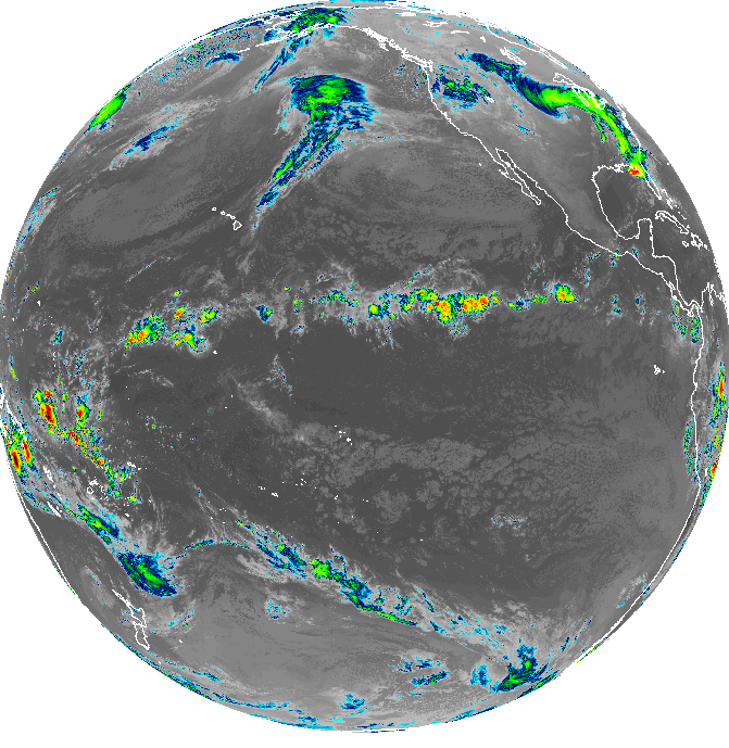
Here is GOES WEST image of the storm we are all watching just northeast of Hawaii and in the GOA. It will merge with an Aleutian trough the coming days before diving southward towards SoCal/Baja.
2 likes
The above post and any post by Ntxw is NOT an official forecast and should not be used as such. It is just the opinion of the poster and may or may not be backed by sound meteorological data. It is NOT endorsed by any professional institution including Storm2k. For official information, please refer to NWS products.
Help support Storm2K!
Help support Storm2K!
-
Haris

- Category 5
- Posts: 1814
- Joined: Mon Nov 27, 2017 8:19 pm
- Location: ( Bee Cave) West Austin, Texas
Re: Texas Winter 2018-2019


2 likes
Weather geek and a storm spotter in West Austin. Not a degreed meteorologist. Big snow fan. Love rain and cold! Despise heat!
Re: Texas Winter 2018-2019
As a new fun tool we also have the GOES 17 satellite pre-operational (future goes west). Reminds us El Nino is definitely still out there with near linear convection close to the Equator. Storms that dig enough south to tap it become high qpf events.
1 likes
The above post and any post by Ntxw is NOT an official forecast and should not be used as such. It is just the opinion of the poster and may or may not be backed by sound meteorological data. It is NOT endorsed by any professional institution including Storm2k. For official information, please refer to NWS products.
Help support Storm2K!
Help support Storm2K!
-
spencer817

- Tropical Storm

- Posts: 197
- Age: 27
- Joined: Thu Nov 17, 2016 3:22 pm
- Location: Coppell, TX
Re: Texas Winter 2018-2019
12z ensembles are encouraging for an ice storm, many of them just west of DFW. A couple have an ice storm here, and a few with back end snow! 
3 likes
I'm going to go to school for this stuff 
Re: Texas Winter 2018-2019
It digs really far south on that run. Central part of the Baja..pretty wild.
0 likes
Re: Texas Winter 2018-2019
FV3 is colder than the GFS. Everything is west and North of DFW but is a blizzard for West, NW Texas, and Oklahoma.
7 days out! Don't be in the bulls-eye
7 days out! Don't be in the bulls-eye
2 likes
The above post and any post by Ntxw is NOT an official forecast and should not be used as such. It is just the opinion of the poster and may or may not be backed by sound meteorological data. It is NOT endorsed by any professional institution including Storm2k. For official information, please refer to NWS products.
Help support Storm2K!
Help support Storm2K!
Who is online
Users browsing this forum: No registered users and 199 guests