Texas Winter 2011-2012...
Moderator: S2k Moderators
Forum rules
 The posts in this forum are NOT official forecast and should not be used as such. They are just the opinion of the poster and may or may not be backed by sound meteorological data. They are NOT endorsed by any professional institution or STORM2K.

The posts in this forum are NOT official forecast and should not be used as such. They are just the opinion of the poster and may or may not be backed by sound meteorological data. They are NOT endorsed by any professional institution or STORM2K.

Breaking News: On Thursday February 2nd, Houston is forecasted in the lower 70s under partly sunny skies. With this it is expected that Wxman57 will see his shadow riding his bike bringing 6 more weeks of winter (+ 1 extra day in Feb since it's a leap year  ). However depending on the timing of the weekend system clouds may spread ahead of this time, stay tuned!
0 likes
The above post and any post by Ntxw is NOT an official forecast and should not be used as such. It is just the opinion of the poster and may or may not be backed by sound meteorological data. It is NOT endorsed by any professional institution including Storm2k. For official information, please refer to NWS products.
Help support Storm2K!
-
weatherdude1108
- Category 5

- Posts: 4228
- Joined: Tue Dec 13, 2011 1:04 pm
- Location: Northwest Austin/Cedar Park, TX
It may not be Winter precip, but I'm happy for the rain prospects for central Texas!

000
FXUS64 KEWX 302102
AFDEWX
AREA FORECAST DISCUSSION
NATIONAL WEATHER SERVICE AUSTIN/SAN ANTONIO TX
302 PM CST MON JAN 30 2012
.DISCUSSION...
AN ACTIVE SOUTHERN STREAM WILL KEEP AREA MOIST FOR THE NEXT SEVERAL
DAYS. MUCH WARMER TONIGHT WITH THE INCREASED SOUTHERLY FLOW OF GULF
MOISTURE. LOWS TONIGHT NEAR 50 HILLS TO THE MID AND UPPER 50S ELSE-
WHERE. SOME LOW CHANCES OF SHOWERS POSSIBLE TONIGHT AS WEAK UPPER
DISTURBANCES TRAVERSE NORTHEAST. PATCHY FOG WILL ALSO DEVELOP MAINLY
ALONG AND EAST OF THE I-35 CORRIDOR. AFTER SUNRISE CONTINUED MOIST
ADVECTION AND LIGHT SOUTHERLY FLOW UPLIFTING ALONG THE ESCARPMENT
MAY BRING DENSE FOG TO ESCARPMENT AREAS...LIFTING RAPIDLY BY LATE
MORNING. AGAIN...A SLIGHT CHANCE OF SHOWERS MAINLY EAST OF THE
I-35 CORRIDOR DURING THE DAY TUESDAY WHILE BECOMING PARTLY CLOUDY
WESTERN PORTIONS DURING THE AFTERNOON. UNDER INCREASINGLY ZONAL
FLOW ALOFT...CONTINUED LIGHT SOUTHERLY FLOW AT THE SURFACE AND
RADIATIONAL COOLING ALOFT WILL PROMOTE WIDESPREAD AREAS OF DENSE
FOG DEVELOPING LATE TUESDAY NIGHT/EARLY WEDNESDAY MORNING AND
CONTINUING THROUGH LATE WEDNESDAY MORNING. A WEAK COLD FRONT/DRY
LINE WILL PUSH INTO WEST PORTIONS WEDNESDAY MORNING IN ASSOCIATION
WITH A FAST MOVING SHORT WAVE SWEEPING OVER NORTHERN TEXAS. THE
FRONT WILL PUSH THROUGH THE AREA BY 00Z THURSDAY (6 PM WEDNESDAY).
MOISTURE WILL OVERRUN THE SHALLOW COOL BOUNDARY EARLY THURSDAY
WITH POTENTIAL FOG PROBLEMS AGAIN ALONG PORTIONS OF THE ESCARPMENT
THURSDAY MORNING. THE NEXT SYSTEM...DIGGING SOUTH INTO THE
SOUTHERN ROCKIES THURSDAY WILL RESULT IN STRONG AND MOIST LOW
LEVEL WARM ADVECTION THURSDAY NIGHT INTO FRIDAY MORNING WITH LOWS
ONLY IN THE LOW TO MID 60S. A SLIGHT CHANCE FOR SHOWERS THURSDAY
NIGHT IN THE ACTIVE SOUTHERN STREAM. INCREASING CHANCES FOR SHOWERS
FRIDAY AS THE SYSTEM APPROACHES AND GULF MOISTURE CONTINUES TO
BUILD. BOTH EUROPEAN AND GFS MODELS SIMILAR IN PRODUCING AN
ELONGATED LOW PRESSURE PATTERN ALOFT FROM THE SOUTHWEST U.S. TO
THE PLAINS WITH THE GFS A LITTLE LESS PROGRESSIVE AND DUG A LITTLE
LESS. NONETHELESS...BOTH MODELS MAINTAIN A MOIST SOUTHWEST FLOW
ALOFT. BOTH MODELS ALSO PUSH A COLD FRONT INTO THE AREA LATE
FRIDAY INTO SATURDAY MORNING. THUNDERSTORMS SHOULD DEVELOP ALONG
THE FRONT AS IT MOVES THROUGH THE REGION WITH SOME OF THESE STORMS
POTENTIALLY GIVING US SOME BENEFICIAL RAINS AND EVEN POSSIBLY SOME
SMALL HAIL. WITH PASSAGE OF THE COLD FRONT SATURDAY...OVERRUNNING
RAINS AND ELEVATED SHOWERS ARE EXPECTED WITH A CONTINUED SOUTHWEST
FLOW PATTERN ALOFT.
0 likes
The preceding post is NOT an official forecast, and should not be used as such. It is only the opinion of the poster and may or may not be backed by sound meteorological data. It is NOT endorsed by any professional institution including storm2k.org. For Official Information please refer to the NHC and NWS products.
-
weatherdude1108
- Category 5
- Posts: 4228
- Joined: Tue Dec 13, 2011 1:04 pm
- Location: Northwest Austin/Cedar Park, TX
Bob Rose thinks some interesting (colder) weather may be in store for central Texas in 10 days to two weeks. 
http://www.lcra.org/water/conditions/we ... olumn.html
http://www.lcra.org/water/conditions/we ... olumn.html
0 likes
The preceding post is NOT an official forecast, and should not be used as such. It is only the opinion of the poster and may or may not be backed by sound meteorological data. It is NOT endorsed by any professional institution including storm2k.org. For Official Information please refer to the NHC and NWS products.
-
HockeyTx82
- S2K Supporter

- Posts: 2774
- Joined: Tue Oct 27, 2009 11:17 am
- Location: Ponder, TX
Re: Texas Winter 2011-2012...
Me being a runner, I got a kick out of this story. Wxman, what's your take on this? I know how you bikers can't stand the cold. 
http://newsminer.com/bookmark/17330613- ... celations-
Five runners brave -49 for Chilly Buns Run; extreme cold postpones, cancels other races
by Bob Eley/beley@newsminer.com Fairbanks Daily News Miner
Jan 28, 2012 | 13253 views | 0 | 16 | | FAIRBANKS—Six Fairbanks runners proved to be nearly superhuman or maybe insane, by completing Running Club North’s Chilly Buns Mid-winter Fun Run Saturday morning.
The temperature was 49 below when the 6.4-mile race began at the University of Alaska Fairbanks Patty Center parking lot, with thick ice fog shrouding low lying portions of the hilly course.
Five of the six participants insisted on running the entire course, which follows Sheep Creek, Mill Hill, Yankovich, Ballaine roads and returns to the starting line via Farmers Loop and campus roads. The low-lying areas of the course
All finished safely and in good spirits, according to finisher Jane Lanford.
Dirk Nickish was the first finisher in 50 minutes and 14 seconds, followed closely by Bruce Sackinger in 50:51.
Lanford, the only female participant, finished third in 57:02. Don Kiely crossed the line in 58:06 and Bob Vitale finished in 60:52.
Paul Reynolds ran a 2.5-mile course in 30 minutes.
0 likes
Don't hold me accountable for anything I post on this forum. Leave the real forecasting up to the professionals.
Location: Ponder, TX (all observation posts are this location unless otherwise noted)
Location: Ponder, TX (all observation posts are this location unless otherwise noted)
-
Tireman4

- S2K Supporter
- Posts: 5903
- Age: 60
- Joined: Fri Jun 30, 2006 1:08 pm
- Location: Humble, Texas
- Contact:
Re: Texas Winter 2011-2012...
HockeyTx82 wrote:Me being a runner, I got a kick out of this story. Wxman, what's your take on this? I know how you bikers can't stand the cold.
http://newsminer.com/bookmark/17330613- ... celations-
Five runners brave -49 for Chilly Buns Run; extreme cold postpones, cancels other races
by Bob Eley/beley@newsminer.com Fairbanks Daily News Miner
Jan 28, 2012 | 13253 views | 0 | 16 | | FAIRBANKS—Six Fairbanks runners proved to be nearly superhuman or maybe insane, by completing Running Club North’s Chilly Buns Mid-winter Fun Run Saturday morning.
The temperature was 49 below when the 6.4-mile race began at the University of Alaska Fairbanks Patty Center parking lot, with thick ice fog shrouding low lying portions of the hilly course.
Five of the six participants insisted on running the entire course, which follows Sheep Creek, Mill Hill, Yankovich, Ballaine roads and returns to the starting line via Farmers Loop and campus roads. The low-lying areas of the course
All finished safely and in good spirits, according to finisher Jane Lanford.
Dirk Nickish was the first finisher in 50 minutes and 14 seconds, followed closely by Bruce Sackinger in 50:51.
Lanford, the only female participant, finished third in 57:02. Don Kiely crossed the line in 58:06 and Bob Vitale finished in 60:52.
Paul Reynolds ran a 2.5-mile course in 30 minutes.
Me, being a runner as well ( for over 30 years) aint never run in anything that cold. The coldest I have run in has been 29 degrees. Nope, not for me. LOL
0 likes
-
wxman57

- Moderator-Pro Met

- Posts: 23170
- Age: 68
- Joined: Sat Jun 21, 2003 8:06 pm
- Location: Houston, TX (southwest)
Re:
Ntxw wrote:Breaking News: On Thursday February 2nd, Houston is forecasted in the lower 70s under partly sunny skies. With this it is expected that Wxman57 will see his shadow riding his bike bringing 6 more weeks of winter (+ 1 extra day in Feb since it's a leap year
I must protest the added day of winter this year (Feb. 29th). Why not add an extra day to June?
Remember 15 days ago when the GFS was forecasting that big pattern change and an Arctic front arriving on the 2nd? Today's 12Z GFS run was clearly an extreme run. It's not likely to happen. 18Z GFS says "what cold front"? My vote is for persistence of pattern until something other than the 12-15 day GFS says so.
0 likes
-
Portastorm

- Storm2k Moderator

- Posts: 9954
- Age: 63
- Joined: Fri Jul 11, 2003 9:16 am
- Location: Round Rock, TX
- Contact:
Re: Re:
wxman57 wrote:Ntxw wrote:Breaking News: On Thursday February 2nd, Houston is forecasted in the lower 70s under partly sunny skies. With this it is expected that Wxman57 will see his shadow riding his bike bringing 6 more weeks of winter (+ 1 extra day in Feb since it's a leap year
I must protest the added day of winter this year (Feb. 29th). Why not add an extra day to June?
Remember 15 days ago when the GFS was forecasting that big pattern change and an Arctic front arriving on the 2nd? Today's 12Z GFS run was clearly an extreme run. It's not likely to happen. 18Z GFS says "what cold front"? My vote is for persistence of pattern until something other than the 12-15 day GFS says so.
The Euro weeklies and the CFS-2 models some two to three weeks out also show some impressive cold air on the way. That should qualify as "something other than the 12-15 day GFS ..."
But I will give you props wxman57 if your warm pattern is helping to create these rain chances. If it was below normal cold here, I bet it would be drier. So you see ... I'm trying to find something positive to say about the lack of winter this year.
0 likes
Any forecasts under my name are to be taken with a grain of salt. Get your best forecasts from the National Weather Service and National Hurricane Center.


Re: Re:
wxman57 wrote:Ntxw wrote:Breaking News: On Thursday February 2nd, Houston is forecasted in the lower 70s under partly sunny skies. With this it is expected that Wxman57 will see his shadow riding his bike bringing 6 more weeks of winter (+ 1 extra day in Feb since it's a leap year
I must protest the added day of winter this year (Feb. 29th). Why not add an extra day to June?
Remember 15 days ago when the GFS was forecasting that big pattern change and an Arctic front arriving on the 2nd? Today's 12Z GFS run was clearly an extreme run. It's not likely to happen. 18Z GFS says "what cold front"? My vote is for persistence of pattern until something other than the 12-15 day GFS says so.
You're not going to like the Euro weeklies for weeks 2,3, and 4. Reports are they are showing a -EPO, +PNA, -NAO pattern. This is significant, according to DT (David Tolleris with Wxrisk), because this is the first time they have wavered from their warm forecasts in quite some time. This, together with the forecasted MJO progression and teleconnection index trends, lends more credence to the idea of a pattern flip, which may be able to lock in.
0 likes
Re: Re:
wxman57 wrote:
I must protest the added day of winter this year (Feb. 29th). Why not add an extra day to June?
Well every year except in leap years you get an extra day of summer already. Both July AND August have 31 while we cold mongerers are left with 28 in our best winter month
I do like the teleconnection indices this time better. The AO is very negative and has staying power being so low. It may or may not get super cold but I think February will be a far cry from the warm winter thus far. I'll take normal chill at this point
0 likes
The above post and any post by Ntxw is NOT an official forecast and should not be used as such. It is just the opinion of the poster and may or may not be backed by sound meteorological data. It is NOT endorsed by any professional institution including Storm2k. For official information, please refer to NWS products.
Help support Storm2K!
Help support Storm2K!
-
Rgv20

- S2K Supporter
- Posts: 2466
- Age: 39
- Joined: Wed Jan 05, 2011 5:42 pm
- Location: Edinburg/McAllen Tx
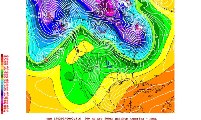
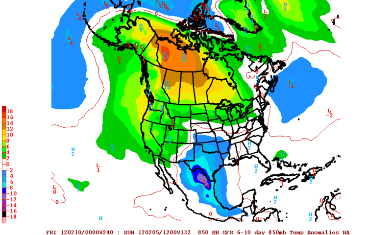
Interesting that the 0zGFS has a 1045mb high in Nebraska by 216hrs which is 2 days earlier than the 12zGFS which earlier showed a monster 1061mb high in Nebraska......IMO What it looks like in the 0zGFS run is that this High pressure does not tap in to some Arctic air. Of course in these long ranges one can not get caught up in details and just take note that the GFS is hinting at some cooler temperatures in 7 days and beyond.
0zGFS forecast...note the 1045mb high in Nebraska 216 hrs out
0zGFS forecast 850mb Temperature Anomalies shows cool weather sticking around in the 6 to 10 day time frame.
0zGFS forecast...note the 1045mb high in Nebraska 216 hrs out
0zGFS forecast 850mb Temperature Anomalies shows cool weather sticking around in the 6 to 10 day time frame.
0 likes
The following post is NOT an official forecast and should not be used as such. It is just the opinion of the poster and may or may not be backed by sound meteorological data. It is NOT endorsed by any professional institution including storm2k.org For Official Information please refer to the NHC and NWS products.
-
Portastorm
- Storm2k Moderator
- Posts: 9954
- Age: 63
- Joined: Fri Jul 11, 2003 9:16 am
- Location: Round Rock, TX
- Contact:
Re: Texas Winter 2011-2012...
Medium-range models still struggling mightily with the upcoming pattern. Here's a good read:
PRELIMINARY EXTENDED FORECAST DISCUSSION
NWS HYDROMETEOROLOGICAL PREDICTION CENTER CAMP SPRINGS MD
359 AM EST TUE JAN 31 2012
VALID 12Z SAT FEB 04 2012 - 12Z TUE FEB 07 2012
CONFIDENCE IN THE MEDIUM RANGE FCST CONTINUES TO BE LOWER THAN
AVERAGE WITH EXPECTED COMPLEX FLOW OVER NORTH AMERICA LEADING TO
SIGNIFICANT SPREAD AND RUN TO RUN/DAY TO DAY CONTINUITY CHANGES
WITH IMPORTANT DETAILS. FROM THE LARGE SCALE MEAN PERSPECTIVE
THERE HAS BEEN SOME DEGREE OF PERSISTENCE WITH RESPECT TO A WRN
NOAM MEAN RIDGE BUT SIGNIFICANT VARIABILITY HAS BEEN NOTED WITH
THE EXTENT TO WHICH EJECTING ERN PAC MEAN TROF ENERGY MAY INTRUDE
UPON THE MEAN RIDGE AND THE AMPLITUDE OF FLOW DOWNSTREAM FROM THE
RIDGE. THESE ISSUES IMPACT THE EVENTUAL PROGRESSION/EVOLUTION OF
THE STRONG SYSTEM OVER THE ROCKIES/PLAINS LATE THIS WEEK.
MEANWHILE MULTI-DAY TRENDS APPEAR TO BE DELAYING AMPLIFICATION OF
AN ERN NOAM MEAN TROF EXPECTED TO DEVELOP IN RESPONSE TO THE CORE
OF POSITIVE HGT ANOMALIES OVER WRN CANADA.
AT THE START OF THE PERIOD FRI THERE CONTINUES TO BE CONVERGENCE
TOWARD THE SLOWER SIDE OF THE ENVELOPE FOR THE TROF AMPLIFYING
OVER THE ROCKIES AND PLAINS SFC LOW PRESSURE... WITH THE GFS/ECMWF
OFFERING REASONABLE SOLNS. HOWEVER THE GFS IS A DEEP EXTREME WITH
ENERGY OVER/NEAR THE N-CNTRL ROCKIES AND THE GFS/GEFS MEAN APPEAR
TOO AGGRESSIVE IN BRINGING HGT FALLS FROM OFF THE PAC NW COAST
INTO SWRN CANADA FRI-SUN SO THOSE SOLNS HAVE THE POTENTIAL TO BE
TOO FAST WITH THE PLAINS SYSTEM AFTER EARLY FRI. THE CMC ALREADY
STARTS OUT ON THE FAST SIDE OF GUIDANCE EARLY FRI AND WHILE THE
UKMET ALSO BRINGS ITS SYSTEM ACROSS THE PLAINS FASTER THAN THE
ECMWF... THE DEGREE TO WHICH HGTS RISE OVER SRN CANADA AND THE NRN
PLAINS WOULD SEEM TO SUPPORT RATHER SLOW PROGRESSION OF THE PLAINS
CLOSED LOW. AS A RESULT THE DAYS 3-4 FRI-SAT FCST IS BASED ON THE
00Z ECMWF.
BY DAYS 5-7 SUN-TUE GFS/GEFS MEAN REMAIN MORE PROGRESSIVE THAN THE
ECMWF OVER THE CNTRL/ERN STATES DUE TO THE FLOW WHICH THE GFS/GEFS
MEAN BRING INTO SWRN CANADA AROUND MID-PERIOD. ON THE POSITIVE
SIDE BY DAY 7 THEY REBUILD THE WRN NOAM RIDGE TO THE STRENGTH
DEPICTED BY OTHER SOLNS... THOUGH THE GFS SHOWS GREATER EWD EXTENT
OF THE RIDGE THAN CONSENSUS. CONTINUITY TO SOME DEGREE AND
TELECONNECTIONS RELATIVE TO WRN CANADA POSITIVE HGT ANOMALIES
FAVOR SOME INCLUSION OF THE 12Z ECMWF ENSEMBLE MEAN WHICH SHOWS
MORE ERN CONUS TROFFING THAN SEEN IN THE 00Z ECMWF. INITIALLY
PREFER AN EVEN BLEND FOR DAY 5 AND A 70 PCT WEIGHTING OF THE 12Z
ECMWF MEAN VERSUS THE 00Z ECMWF BY DAYS 6-7 AS CONFIDENCE IN
OPERATIONAL DETAILS BECOMES QUITE LOW.
RAUSCH
0 likes
Any forecasts under my name are to be taken with a grain of salt. Get your best forecasts from the National Weather Service and National Hurricane Center.
-
wxman57
- Moderator-Pro Met
- Posts: 23170
- Age: 68
- Joined: Sat Jun 21, 2003 8:06 pm
- Location: Houston, TX (southwest)
Re: Texas Winter 2011-2012...
It's becoming clear that yesterday's 12Z GFS run was a very extreme run. While models do indicate some Canadian/Arctic air moving south into the U.S. next week, they're not indicating a flow pattern that would bring it south down the Plains but rather southeast across the Great Lakes. The latest runs of the GFS don't even have any freezing temps in Texas (except for the panhandle) over the next 2 weeks. Euro agrees with that.
0 likes
-
orangeblood
- S2K Supporter
- Posts: 3895
- Joined: Tue Dec 15, 2009 6:14 pm
- Location: Fort Worth, TX
Re: Texas Winter 2011-2012...
Watch out wxman57....for the first time all winter the Polar Vortex looks like it's forecast by most models to split over the next 7-10 days, with a huge chunk diving down into Hudson Bay. That should set the stage for a Major pattern change!!
0 likes
Re: Texas Winter 2011-2012...
orangeblood wrote:Watch out wxman57....for the first time all winter the Polar Vortex looks like it's forecast by most models to split over the next 7-10 days, with a huge chunk diving down into Hudson Bay. That should set the stage for a Major pattern change!!
And once the Hudson Bay vortex provides the cold pool in Canada, we wait for the MJO to translate the +PNA into a -EPO. This is the classic configuration for an arctic attack. It's going to take some time yet...sigh. Also this weekend's blizzard is going to lay a substantial amount of snow into the the northern and central plains in a double barrell low type set up.
You know it's mild in Indy right now for super bowl week. Jerry just can't catch a break with his major sporting events lol.
0 likes
The above post and any post by Ntxw is NOT an official forecast and should not be used as such. It is just the opinion of the poster and may or may not be backed by sound meteorological data. It is NOT endorsed by any professional institution including Storm2k. For official information, please refer to NWS products.
Help support Storm2K!
Help support Storm2K!
-
Portastorm
- Storm2k Moderator
- Posts: 9954
- Age: 63
- Joined: Fri Jul 11, 2003 9:16 am
- Location: Round Rock, TX
- Contact:
Re: Texas Winter 2011-2012...
Interestingly enough, I was telling my boys last night that the pattern which should be upon us around February 10th reminded me a lot of the pattern we saw last February during the first week. I'm anticipating an Arctic outbreak into Texas and at least one decent frozen precip threat.
0 likes
Any forecasts under my name are to be taken with a grain of salt. Get your best forecasts from the National Weather Service and National Hurricane Center.
-
wxman57
- Moderator-Pro Met
- Posts: 23170
- Age: 68
- Joined: Sat Jun 21, 2003 8:06 pm
- Location: Houston, TX (southwest)
Re: Texas Winter 2011-2012...
orangeblood wrote:Watch out wxman57....for the first time all winter the Polar Vortex looks like it's forecast by most models to split over the next 7-10 days, with a huge chunk diving down into Hudson Bay. That should set the stage for a Major pattern change!!
I'm watching. Hopefully, the cold just tracks SE across the NE U.S. and not south down the Plains. I'll worry about it when it gets closer. Today's Euro is a bit more scary than the GFS, as it indicates at least the potential for a southward transport vs. E-SE. But that's all at close to 10 days out, and the models are still having lots of trouble just 4-5 days out.
0 likes
-
MGC

- S2K Supporter
- Posts: 5940
- Joined: Sun Mar 23, 2003 9:05 pm
- Location: Pass Christian MS, or what is left.
Re: Texas Winter 2011-2012...
How many time this winter have the models in the medium to long range forecast a major arctic intrusion into the deep south only to be proven wrong? I for one don't put much faith in the models right now. I know they will eventually get it right but given the models track record this winter I'd hedge my bets. Hopefully the cold air will stay over in Europe and Asia the remainder of this winter......MGC
0 likes
Re: Texas Winter 2011-2012...
MGC wrote:How many time this winter have the models in the medium to long range forecast a major arctic intrusion into the deep south only to be proven wrong? I for one don't put much faith in the models right now. I know they will eventually get it right but given the models track record this winter I'd hedge my bets. Hopefully the cold air will stay over in Europe and Asia the remainder of this winter......MGC
Models are wrong
0 likes
The above post and any post by Ntxw is NOT an official forecast and should not be used as such. It is just the opinion of the poster and may or may not be backed by sound meteorological data. It is NOT endorsed by any professional institution including Storm2k. For official information, please refer to NWS products.
Help support Storm2K!
Help support Storm2K!

Re: Texas Winter 2011-2012...
Ntxw wrote:MGC wrote:How many time this winter have the models in the medium to long range forecast a major arctic intrusion into the deep south only to be proven wrong? I for one don't put much faith in the models right now. I know they will eventually get it right but given the models track record this winter I'd hedge my bets. Hopefully the cold air will stay over in Europe and Asia the remainder of this winter......MGC
Models are wrong. They currently are not showing a major outbreak of cold. We are banking on the teleconnections to come through. I hope it does get cold and snowy even if it's not for Texas or the south. I had a friend call from the upper midwest and the lack of snow cover there is hurting the farmers and will be hard felt come melting season (if there is anything to melt). This is going to effect our pockets even more as drought has already taking a toll on the cattle industry and soon the midwest farming industry.
That has me concerned.
0 likes
Who is online
Users browsing this forum: SnowyOwl31 and 62 guests