Texas Winter 2018-2019
Moderator: S2k Moderators
Forum rules
 The posts in this forum are NOT official forecast and should not be used as such. They are just the opinion of the poster and may or may not be backed by sound meteorological data. They are NOT endorsed by any professional institution or STORM2K.

The posts in this forum are NOT official forecast and should not be used as such. They are just the opinion of the poster and may or may not be backed by sound meteorological data. They are NOT endorsed by any professional institution or STORM2K.


Re: Texas Winter 2018-2019
You know the Northeast folks are watching this like a hawk also. A bigger, snowier storm in Texas also likely translates to a KU nor'easter event for them.
1 likes
The above post and any post by Ntxw is NOT an official forecast and should not be used as such. It is just the opinion of the poster and may or may not be backed by sound meteorological data. It is NOT endorsed by any professional institution including Storm2k. For official information, please refer to NWS products.
Help support Storm2K!

Re: Texas Winter 2018-2019
Ntxw wrote:You know the Northeast folks are watching this like a hawk also. A bigger, snowier storm in Texas also likely translates to a KU nor'easter event for them.
Snow totals in Missouri over 2 feet on that run lol
0 likes
-
TeamPlayersBlue

- Category 5

- Posts: 3531
- Joined: Tue Feb 02, 2010 1:44 am
- Location: Denver/Applewood, CO
Re: Texas Winter 2018-2019
www.fantasyblizzard.com I just signed up, looks like lots of fun!
0 likes
Personal Forecast Disclaimer:
The posts in this forum are NOT official forecast and should not be used as such. They are just the opinion of the poster and may or may not be backed by sound meteorological data. They are NOT endorsed by any professional institution or storm2k.org. For official information, please refer to the NHC and NWS products.
The posts in this forum are NOT official forecast and should not be used as such. They are just the opinion of the poster and may or may not be backed by sound meteorological data. They are NOT endorsed by any professional institution or storm2k.org. For official information, please refer to the NHC and NWS products.
-
Brent
- S2K Supporter

- Posts: 38769
- Age: 37
- Joined: Sun May 16, 2004 10:30 pm
- Location: Tulsa Oklahoma
- Contact:
Re: Texas Winter 2018-2019
Ntxw wrote:FV3 is colder than the GFS. Everything is west and North of DFW but is a blizzard for West, NW Texas, and Oklahoma.
7 days out! Don't be in the bulls-eye
Yeah being in the bullseye 7 days out doesn't usually work
0 likes
#neversummer
Re: Texas Winter 2018-2019
12z Euro looks a lot like the FV3 and a tad colder than 0z. Now just get this thing inside 100 hours. 144+ hours still...Going to be another long week with gnashing of teeth.
One thing I am noticing (given far out caveat per usual) the models are developing surface low in Central and Southeast Texas. Generally there is a sharp cutoff once you get inside very high resolution instead of the broad qpf shield. This is why you don't want to be in the bulls-eye 7 days out. If that surface low track manifests, historically the precip shield doesn't end up much north of the Red River. Okahoma storms usually have a surface low that travels from Lubbock->Dallas->Texarkana.
One thing I am noticing (given far out caveat per usual) the models are developing surface low in Central and Southeast Texas. Generally there is a sharp cutoff once you get inside very high resolution instead of the broad qpf shield. This is why you don't want to be in the bulls-eye 7 days out. If that surface low track manifests, historically the precip shield doesn't end up much north of the Red River. Okahoma storms usually have a surface low that travels from Lubbock->Dallas->Texarkana.
2 likes
The above post and any post by Ntxw is NOT an official forecast and should not be used as such. It is just the opinion of the poster and may or may not be backed by sound meteorological data. It is NOT endorsed by any professional institution including Storm2k. For official information, please refer to NWS products.
Help support Storm2K!
Help support Storm2K!
-
srainhoutx

- S2K Supporter
- Posts: 6919
- Age: 68
- Joined: Sun Jan 14, 2007 11:34 am
- Location: Haywood County, NC
- Contact:
Re: Texas Winter 2018-2019
Saturday midday briefing from Jeff:
Overall pretty much a temperature forecast for the next several days as moisture has been scoured out of the area by recent frontal passages.
Temperatures today and Sunday will run near to above normal with clear skies and a dry air mass in place with highs in the 70’s and lows in the 40’s and 50’s. A stronger cold front will move across the area late Sunday into early Monday with strong cold air advection and a noticeable drop in temperatures. Highs Monday-Tuesday will drop into the 50’s with lows falling back into the 30’s and 40’s over the region. Could see a light freeze Tuesday or Wednesday morning over our northern and northeastern counties. Southerly flow begins to return to the area on Wednesday with moisture deepening. Not expecting any rainfall today-Wednesday.
Late Next Week:
Forecast models including the GFS, ECMWF, and CMC all pointing to a fairly strong storm system digging far south into northern MX and then ejecting eastward across TX around Friday-Saturday. There are still some timing differences…although the major global models are really not that far apart from each other…pointing toward a Friday afternoon into early Saturday event. Models are however handling a surging arctic cold front differently and track of a surface low pressure system differently as one would expect at this long range. CMC is much faster with the intrusion of a shallow cold air mass down the plains and into TX and has much more winter precipitation across NC/NW TX where the GFS and ECMWF is slower and warmer. Will side with the ECWMF and GFS solutions for now, but these shallow cold air masses tend to plow southward faster than models usually suggest and this could make for a tricky temperature forecast on Friday with a warm and humid air mass near the coast and a cold arctic air mass sliding into our NW counties. Looks to be plenty of moisture with this system with the most recent GFS run showing a rainfall at IAH of around 3 inches and both the ECWMF and CMC models are also fairly wet. Formation and track of the surface low/coastal trough near the coast or inland this time may bring both a heavy rainfall and possible severe threat. Still some questions to be answered and models this time of year tend to overdo longer range depths of systems…so something to watch for the Thursday-Saturday time period.
1 likes
Carla/Alicia/Jerry(In The Eye)/Michelle/Charley/Ivan/Dennis/Katrina/Rita/Wilma/Ike/Harvey
Member: National Weather Association
Wx Infinity Forums
http://wxinfinity.com/index.php
Facebook.com/WeatherInfinity
Twitter @WeatherInfinity
Member: National Weather Association
Wx Infinity Forums
http://wxinfinity.com/index.php
Facebook.com/WeatherInfinity
Twitter @WeatherInfinity
-
spencer817

- Tropical Storm

- Posts: 197
- Age: 27
- Joined: Thu Nov 17, 2016 3:22 pm
- Location: Coppell, TX
Re: Texas Winter 2018-2019
NWS Forecaster's discussion is interesting:
Isolated to scattered light showers may begin to develop across
the area on Thursday as warm advection begins to increase ahead of the aformentioned disturbance. Precipitation coverage willgradually expand through Thursday night as forcing slowly ticks upwards. At the same time, an arctic cold front is forecast to
drop swiftly southward through the Great Plains, and may be
knocking on our doorstep as early as late Thursday night. The
speed/progression and depth/magnitude of the cold air associated
with this next front will obviously play a crucial role in our
forecast towards the end of the week. Forecast soundings show the
associated frontal inversion may only be about 1 kft deep, and
coarse resolution guidance does tend to have a hard time handling
the southward push of these dense, cold, and shallow airmasses.
For now, we`ll just be indicating a cold rain through Friday and
Friday night. In addition, instability may be just high enough to
support some thunder ahead of the cold front, so we`ll indicate
embedded isolated storms across much of the region on Friday.
While this system looks quite dynamic, moisture and instability
return looks pretty meager at this point which should help keep
the severe threat relatively low.
0 likes
I'm going to go to school for this stuff 
-
TheProfessor

- Professional-Met

- Posts: 3506
- Age: 29
- Joined: Tue Dec 03, 2013 10:56 am
- Location: Wichita, Kansas
Re: Texas Winter 2018-2019
Ntxw wrote:You know the Northeast folks are watching this like a hawk also. A bigger, snowier storm in Texas also likely translates to a KU nor'easter event for them.
It's going to be a tricky system for those north of the mid-Atlantic. If the timing is wrong the storm will likely either become suppressed or the storm is late and the cold air retreats.
0 likes
An alumnus of The Ohio State University.
Your local National Weather Service office is your best source for weather information.
Your local National Weather Service office is your best source for weather information.
-
Brent
- S2K Supporter
- Posts: 38769
- Age: 37
- Joined: Sun May 16, 2004 10:30 pm
- Location: Tulsa Oklahoma
- Contact:
Re: Texas Winter 2018-2019
the GFS is so warm lol. Even most of Oklahoma is rain. Can't help and think of all those times the GFS has missed the cold before
0 likes
#neversummer
Re: Texas Winter 2018-2019
Brent wrote:the GFS is so warm lol. Even most of Oklahoma is rain. Can't help and think of all those times the GFS has missed the cold before
Yeah. Cold dome comes Thursday and that's likely the day we get cold timing right.
18z GFS warm (relative to snow) but storm is colder than 12Z
0 likes
The above post and any post by Ntxw is NOT an official forecast and should not be used as such. It is just the opinion of the poster and may or may not be backed by sound meteorological data. It is NOT endorsed by any professional institution including Storm2k. For official information, please refer to NWS products.
Help support Storm2K!
Help support Storm2K!
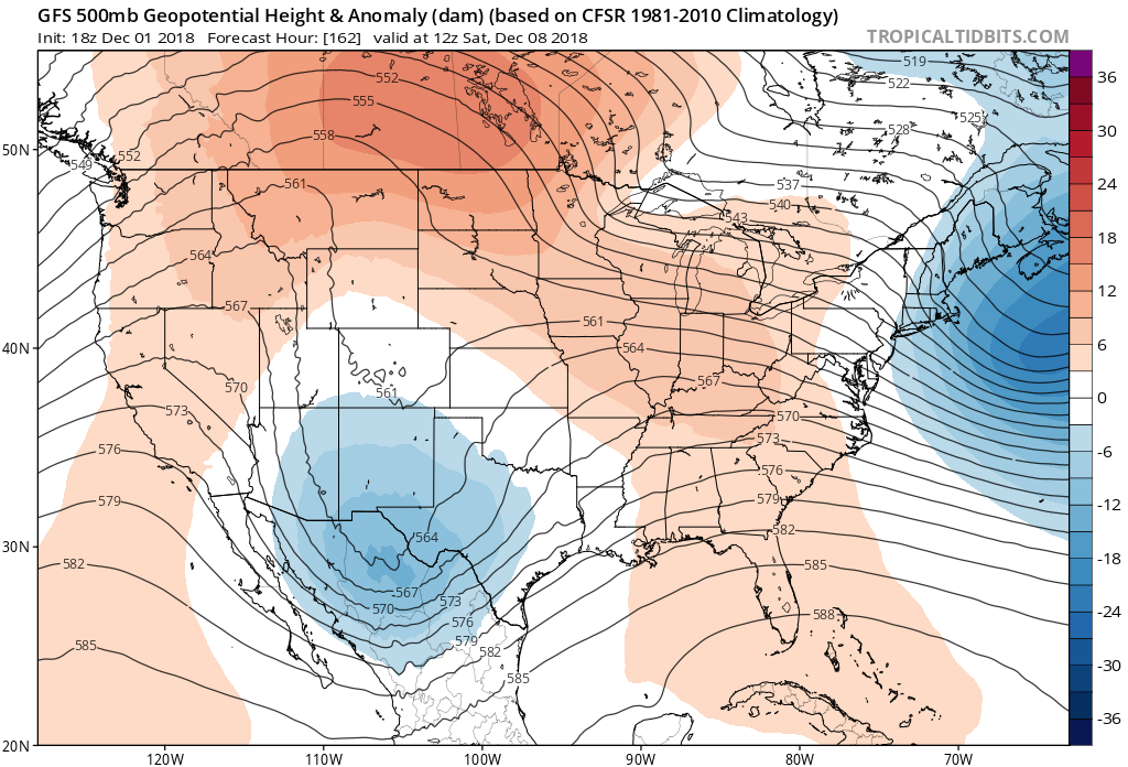
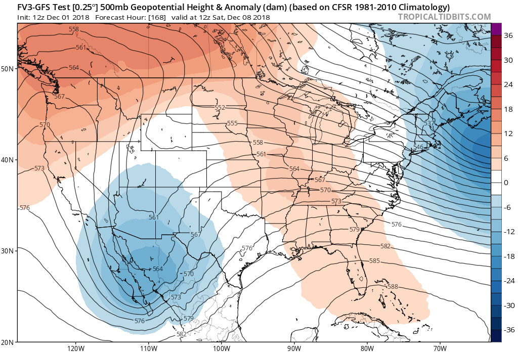
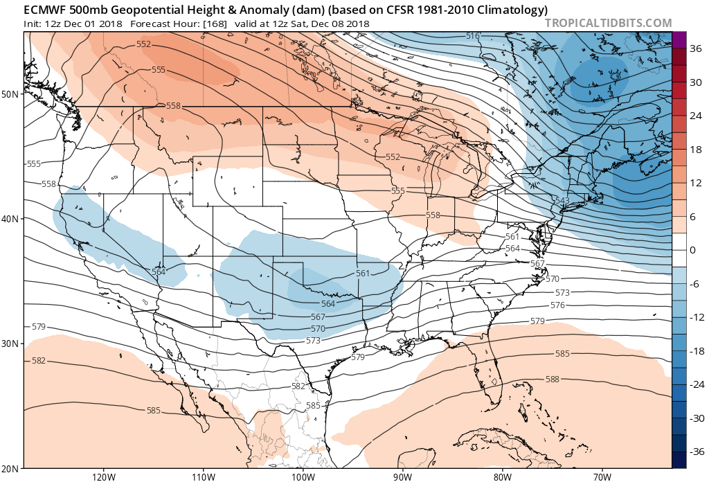
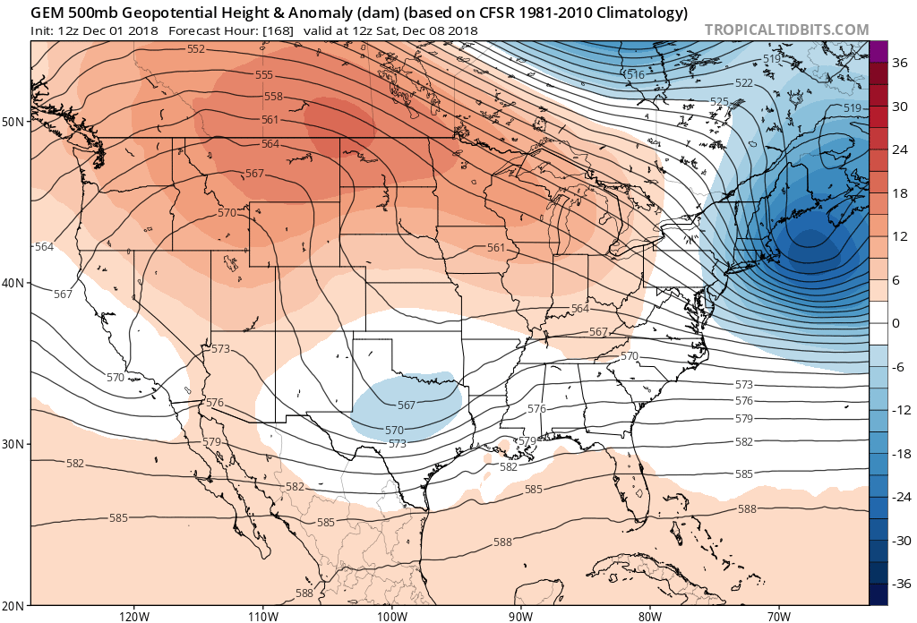
Re: Texas Winter 2018-2019
Below are the panels for 12z SAT for the latest GFS/FV3/Euro/CMC. You can see timing, depth of cold aloft, ejection location is not in lock step. Lots of changes to be had.
2 likes
The above post and any post by Ntxw is NOT an official forecast and should not be used as such. It is just the opinion of the poster and may or may not be backed by sound meteorological data. It is NOT endorsed by any professional institution including Storm2k. For official information, please refer to NWS products.
Help support Storm2K!
Help support Storm2K!
-
Brent
- S2K Supporter
- Posts: 38769
- Age: 37
- Joined: Sun May 16, 2004 10:30 pm
- Location: Tulsa Oklahoma
- Contact:
Re: Texas Winter 2018-2019
the FV is close to snowing Saturday Night, still a week out
0 likes
#neversummer
-
TeamPlayersBlue
- Category 5
- Posts: 3531
- Joined: Tue Feb 02, 2010 1:44 am
- Location: Denver/Applewood, CO
Re: Texas Winter 2018-2019
Still a bit of ways out but the Euro is so diff from the GFS
0 likes
Personal Forecast Disclaimer:
The posts in this forum are NOT official forecast and should not be used as such. They are just the opinion of the poster and may or may not be backed by sound meteorological data. They are NOT endorsed by any professional institution or storm2k.org. For official information, please refer to the NHC and NWS products.
The posts in this forum are NOT official forecast and should not be used as such. They are just the opinion of the poster and may or may not be backed by sound meteorological data. They are NOT endorsed by any professional institution or storm2k.org. For official information, please refer to the NHC and NWS products.
-
BTAYLOR5021
- Tropical Depression

- Posts: 53
- Joined: Mon Jan 09, 2017 9:34 am
Re: Texas Winter 2018-2019
Can someone please advise why the temps are warmer for N Texas vs the southeast. Dallas and ATL are same latitude yet Atl is mostly colder and have been getting more winter storms the passed few years.
0 likes
-
Brent
- S2K Supporter
- Posts: 38769
- Age: 37
- Joined: Sun May 16, 2004 10:30 pm
- Location: Tulsa Oklahoma
- Contact:
Re: Texas Winter 2018-2019
BTAYLOR5021 wrote:Can someone please advise why the temps are warmer for N Texas vs the southeast. Dallas and ATL are same latitude yet Atl is mostly colder and have been getting more winter storms the passed few years.
a lot of it is just luck honestly as it always is with snow in this part of the country... I'm from back east not far from Atlanta and its just as hard if not harder to get winter storms there, but the pattern just has lined up better for them especially last year. They've had plenty of years with nothing too. We'll make up for it eventually, just like when Dallas had the footer some years ago. I lived there 25+ years and had exactly one storm over 3 inches...
Last edited by Brent on Sun Dec 02, 2018 12:17 am, edited 3 times in total.
1 likes
#neversummer
-
spencer817
- Tropical Storm
- Posts: 197
- Age: 27
- Joined: Thu Nov 17, 2016 3:22 pm
- Location: Coppell, TX
Re: Texas Winter 2018-2019
GEFS ensembles are the best they have been for DFW!!! 
2 likes
I'm going to go to school for this stuff
Re: Texas Winter 2018-2019
BTAYLOR5021 wrote:Can someone please advise why the temps are warmer for N Texas vs the southeast. Dallas and ATL are same latitude yet Atl is mostly colder and have been getting more winter storms the passed few years.
+PNA .. here in Texas we need a neutral to slightly negative PNA to get some fun.
0 likes
-
Brent
- S2K Supporter
- Posts: 38769
- Age: 37
- Joined: Sun May 16, 2004 10:30 pm
- Location: Tulsa Oklahoma
- Contact:
Re: Texas Winter 2018-2019
spencer817 wrote:GEFS ensembles are the best they have been for DFW!!!
noticed that and also the op GFS has gotten colder today each run Friday Night
1 likes
#neversummer
-
spencer817
- Tropical Storm
- Posts: 197
- Age: 27
- Joined: Thu Nov 17, 2016 3:22 pm
- Location: Coppell, TX
Re: Texas Winter 2018-2019
Brent wrote:spencer817 wrote:GEFS ensembles are the best they have been for DFW!!!
noticed that and also the op GFS has gotten colder today each run Friday Night
GEFS also dropped mean temps Friday from 50 to 41! Talk about a shift.
1 likes
I'm going to go to school for this stuff
Who is online
Users browsing this forum: No registered users and 126 guests