Temperatures across north Texas this morning range from 71°F in Corsicana to 35°F in Wichita Falls behind the cold front which is currently moving into Dallas County and will clear the 4-County Metroplex within the next hour.
Showers and a few claps of thunder are forming well in advance of the cold front but will be mainly - but not only - concentrated east of the DFW area.
Temperatures will fall into the 30s for everyone this afternoon with subfreezing readings along the Red River, but the precip will have ended before this happens.
Bundle up - wind chill factors will be in the teens and twenties this afternoon with gusty NW winds in excess of 30 mph and thend down into the single digits to around 10°F tonight as actual air temperatures fall into the teens and twenties.
Stay tuned for updates on the possible winter storm moving in for Thursday and Friday.
The latest from Steve McCauley
Texas Winter 2024-2025
Moderator: S2k Moderators
Forum rules
 The posts in this forum are NOT official forecast and should not be used as such. They are just the opinion of the poster and may or may not be backed by sound meteorological data. They are NOT endorsed by any professional institution or STORM2K.

The posts in this forum are NOT official forecast and should not be used as such. They are just the opinion of the poster and may or may not be backed by sound meteorological data. They are NOT endorsed by any professional institution or STORM2K.
Re: Texas Winter 2024-2025
2 likes
-
txtwister78

- Category 5

- Posts: 2136
- Joined: Wed Jan 30, 2019 12:56 pm
- Location: San Antonio
Re: Texas Winter 2024-2025
Overnight NWS Austin/San Antonio forecast discussion. Still a ton of uncertainty further south even despite the warm nose factor as addressed below.
A cold week ahead with below normal climate temperatures and several
nights and mornings below freezing.
- There is low to moderate potential for wintry precipitation sometime
Wednesday afternoon to Friday.
South-Central Texas will be underneath a frigid ridge of high
pressure Monday night and Tuesday morning. With calmer winds and
relatively clear skies, efficient radiational cooling will result in
a frigid night with freezing temperatures across our entire region.
Lows will be in the 20s over much of the area, with valley
temperatures in the Hill Country and southern Edwards Plateau
potentially dropping into the teens. Clear to mostly sunny skies
will allow daytime highs in the upper-40s and 50s Tuesday afternoon.
Lows Tuesday night into Wednesday morning drop into the 20s across
the Hill Country to the mid and upper 20s and perhaps lower 30s
along the Rio Grande and in the San Antonio metro.
By Wednesday, an upper-level low is expected to be over the Baja
California, bringing the southern branch of the polar jet stream
across our area. This will push clouds across Central Texas,
preventing temperatures from rising much during the daytime. Highs
Wednesday and Thursday may reach only the upper-30s to mid-40s for
most areas.
Out ahead of the upper-level disturbance, the steady influx of
moisture with divergent flow aloft and mild isentropic lift will
result in gradually increasing precipitation chances. During the
initial stages on Wednesday, sub-freezing air aloft is expected to
be in place over our area with a dry subcloud layer. If enough
moisture streams into our area, some flurries of wintry mix are
possible mainly over the Rio Grande, southern Edwards Plateau, and
Hill Country including the Austin metro area, though with the dry
layer these will likely be light at most with minimal accumulations.
The upper-level low should evolve into an open trough and begin to
work its way east into Texas Thursday into Friday. This will
significantly increase synoptic-scale ascent and the influx of
moisture into our area. At the same time, winds out ahead of the
trough will be advecting warmer air aloft. While the overall picture
supports precipitation, there remains ample uncertainty regarding
the extent to which warming occurs, which is pivotal in determining
precipitation type. Wednesday night into Thursday morning, low
temperatures are still expected to reach below freezing for much of
the region. A wintry mix is possible for the aforementioned areas,
with rain favored south of US 90. However, given the dry layer, wet-
bulb temperatures could be consistently below 32F at least overnight.
This may allow for temporary transitions into wintry precipitation
for areas initially seeing rain. On Thursday, a prominent warm nose
takes shape aloft on the long-range mean guidance, and we expect
temperature profiles in most areas to support rain. However, with
cold daytime temperatures, not much evaporative cooling would need to
occur to complicate the precipitation picture considerably.
Precipitation may continue into Friday with widespread lift, with the
exact precipitation types depending on the amount of warming
experienced, as well as any dynamic cooling from precipitation. All
in all, our region`s likely position straddling the cold/dry polar
airmass to the north and the warmer and humid maritime airmass to the
south could set up a complex mix of back-and-forth precipitation
types near and along the line of freezing temperatures. In addition,
the evolution of the upper-level low remains subject to considerable
run-to-run variability. All forms of precipitation continue to remain
viable possibilities during this period.
2 likes
-
Brandon8181
- S2K Supporter

- Posts: 431
- Age: 42
- Joined: Tue Jan 04, 2011 4:52 pm
- Location: Tyler, TX
- Contact:
Re: Texas Winter 2024-2025
Ntxw wrote:NWS FW discussion over night (before the 6z suite.) Sometimes it is good to read these discussions rather than just a point forecast. Pretty much highlights everything discussed here..LONG TERM... /Issued 329 AM CST Sun Jan 5 2025/
/Monday Night and Beyond/
Our period of cold temperatures will continue into midweek with
lows dipping into the 20s region wide Monday night, Tuesday night,
and Wednesday night with a few readings in the teens possible
along the Red River. Expect afternoon highs to only peak in the
mid 30s to mid 40s each afternoon Tuesday through Thursday. It is
becoming increasingly likely that a few locations north of I-20
and across the Big Country will struggle to get above freezing on
Wednesday (30-40% chance). This could put further strain on any
vulnerable and unprotected pipes, so prepare accordingly!
By Wednesday, our well advertised upper-level low will slide over
northwestern Mexico. 700mb-300mb Pacific moisture and shortwave
disturbances downstream of the parent low may be sufficient for
the development of light showers or snow over parts of West Texas
during the day, potentially extending into our western North and
Central counties. However, very dry air below 700 mb will prevent
much, if not all, of this precipitation from reaching the ground.
Still, cannot rule out a few sprinkles or flurries during the day
Wednesday west of Highway 281.
Our main event is still expected to occur in the Thursday-Friday
timeframe (Day 5 and Day 6). We are still monitoring for an
increasingly likely period of wintry weather late in the work
week. The ultimate result will depend upon the track and strength
of the aforementioned upper low. Roughly a 1/3 of the most recent
suite of ensemble members (heavy GEFS and GEPS) indicate a warmer
and less favorable for winter weather over North and Central Texas
solution with the cut-off low meandering near Baja California
detached from the main flow aloft until the weekend. A majority
~2/3 of members (heavy EPS) paint a colder, more favorable
scenario for wintry precipitation over our region with the cut-off
low transitioning into an open wave then quickly shifting into the
Southern Plains in that Thursday-Friday timeframe.
As you all know, most Texas winter weather events are a game of
just a few degrees and radically different outcomes can occur with
just slightly colder or slightly warmer temperatures. This event
will be no different. Right now our forecast leans toward the
colder scenario, therefore we have a rain/snow mix over much of
North and Central Texas in the Thursday morning to Friday morning
time frame. There is now a 60-70% chance that our entire forecast
area observes at least measurable (>0.1" of snowfall). We are also
noticing a northward trend in the heavier snow potential with a
majority of GEFS, GEPS, and EPS members painting an area of 2-3"
of snow generally along and just south of the I-20 and I-30
corridors. Portions of Central Texas and the Brazos Valley will
likely see warmer temperatures and more rainfall, potentially a
quick period of freezing rain Thursday night, which would eat into
final snow amounts. Do not take these amounts at face value just
yet! Monitor the trends until we get a bit closer to the event.
Potential failure modes: If we end up just 2-3 degrees warmer than
currently forecast, the potential for wintry weather accumulations
will drastically decrease. Additionally, if our beloved cut-off
low does remain displaced to the southwest, the better lift and
moisture will remain just south of our area, and we could see very
little precipitation extend into our forecast area.
Again, the forecast at this moment does favor wintry precipitation
over North and Central Texas and potentially some larger snowfall
accumulations in the Thursday-Friday time frame. In the next
couple of days, we will start to get some help from additional
medium-range model guidance and hopefully we can obtain a clearer
vision on how this event will unfold. But for now, prepare for the
cold (it starts today!) and keep up-to-date with the most current
forecast.
Langfeld
Very good and in-depth discussion there!
1 likes
I am not a meteorologist. Any post from me should be taken as hobby or fun educational information, but not an accurate source for weather information. Please, refer to your local weather station or National Weather Service for the most up to date information. 


Re: Texas Winter 2024-2025
That's a good front! Winter is here to stay for awhile.

6 likes
The above post and any post by Ntxw is NOT an official forecast and should not be used as such. It is just the opinion of the poster and may or may not be backed by sound meteorological data. It is NOT endorsed by any professional institution including Storm2k. For official information, please refer to NWS products.
Help support Storm2K!
Re: Texas Winter 2024-2025
3 likes
The above post and any post by Ntxw is NOT an official forecast and should not be used as such. It is just the opinion of the poster and may or may not be backed by sound meteorological data. It is NOT endorsed by any professional institution including Storm2k. For official information, please refer to NWS products.
Help support Storm2K!
Help support Storm2K!
-
bubba hotep

- S2K Supporter
- Posts: 6012
- Joined: Wed Dec 28, 2016 1:00 am
- Location: Collin County Texas
Re: Texas Winter 2024-2025
I'm getting nervous about temp profiles even as far north as DFW. Whoever can avoid flipping to freezing rain or sleet will jackpot big time with this one.
3 likes
Winter time post are almost exclusively focused on the DFW area.
-
rwfromkansas
- Category 5
- Posts: 3009
- Joined: Sat Aug 27, 2005 12:47 am
- Location: North Fort Worth
Re: Texas Winter 2024-2025
Brent wrote:Already near blizzard conditions in Kansas City
This is gonna be one of the worst snowstorms on record here
My hometown on HRRR, RAP, even Euro etc. is near/over 20 inches. Just jaw-dropping.
The biggest storm I ever had as a kid was 12. They had 14 after I moved, but nowhere near this.
This is stunning.
On another forum one of the posters is in my hometown, McPherson. Lol.
2 likes
-
bubba hotep
- S2K Supporter
- Posts: 6012
- Joined: Wed Dec 28, 2016 1:00 am
- Location: Collin County Texas
Re: Texas Winter 2024-2025
Brent wrote:From the frozen tundra of Kansas City
https://i.postimg.cc/ppbtsR5p/IMG-20250105-091352994.jpg
I lived through numerous historic Noreasters, but the Front Range Blizzard from a few years ago took the cake. There is just something different about a Plains Blizzard. We were on vacation, and the blizzard hit as we packed up to leave. Needless to say, we got a few extra days in CO lol
2 likes
Winter time post are almost exclusively focused on the DFW area.
-
ThunderSleetDreams

- S2K Supporter
- Posts: 1510
- Age: 43
- Joined: Tue Dec 20, 2011 4:42 pm
- Location: S of Weimar, TX
Re: Texas Winter 2024-2025
rwfromkansas wrote:Brent wrote:Already near blizzard conditions in Kansas City
This is gonna be one of the worst snowstorms on record here
My hometown on HRRR, RAP, even Euro etc. is near/over 20 inches. Just jaw-dropping.
The biggest storm I ever had as a kid was 12. They had 14 after I moved, but nowhere near this.
This is stunning.
On another forum one of the posters is in my hometown, McPherson. Lol.
Go Bullpups!
2 likes
#NeverSummer
I hibernate when it gets above 75 degrees!
I hibernate when it gets above 75 degrees!
-
txtwister78
- Category 5
- Posts: 2136
- Joined: Wed Jan 30, 2019 12:56 pm
- Location: San Antonio
Re: Texas Winter 2024-2025
ICON a little slower with the evolution of the low than previous runs and as a result shifts snow access further north across West Central Texas Wednesday evening into Thursday morning.
2 likes
-
HockeyTx82
- S2K Supporter
- Posts: 2774
- Joined: Tue Oct 27, 2009 11:17 am
- Location: Ponder, TX
Re: Texas Winter 2024-2025
bubba hotep wrote:I'm getting nervous about temp profiles even as far north as DFW. Whoever can avoid flipping to freezing rain or sleet will jackpot big time with this one.
What are you seeing to say this? Just a few posts above said we are in a bullseye for record snow?
And don't we always say the models are slow and warm with cold temps?
Last edited by HockeyTx82 on Sun Jan 05, 2025 10:42 am, edited 1 time in total.
0 likes
Don't hold me accountable for anything I post on this forum. Leave the real forecasting up to the professionals.
Location: Ponder, TX (all observation posts are this location unless otherwise noted)
Location: Ponder, TX (all observation posts are this location unless otherwise noted)
Re: Texas Winter 2024-2025
bubba hotep wrote:I'm getting nervous about temp profiles even as far north as DFW. Whoever can avoid flipping to freezing rain or sleet will jackpot big time with this one.
Whoever is close but just a littler colder will jackpot big time. This is big ticket could be top 5 snowfall event for North Texas.
6 likes
The above post and any post by Ntxw is NOT an official forecast and should not be used as such. It is just the opinion of the poster and may or may not be backed by sound meteorological data. It is NOT endorsed by any professional institution including Storm2k. For official information, please refer to NWS products.
Help support Storm2K!
Help support Storm2K!
Re: Texas Winter 2024-2025
12z ICON is heavy snow for much of North Texas and parts of Central Texas.
5 likes
The above post and any post by Ntxw is NOT an official forecast and should not be used as such. It is just the opinion of the poster and may or may not be backed by sound meteorological data. It is NOT endorsed by any professional institution including Storm2k. For official information, please refer to NWS products.
Help support Storm2K!
Help support Storm2K!
Re: Texas Winter 2024-2025
gpsnowman wrote:Temperatures across north Texas this morning range from 71°F in Corsicana to 35°F in Wichita Falls behind the cold front which is currently moving into Dallas County and will clear the 4-County Metroplex within the next hour.
Showers and a few claps of thunder are forming well in advance of the cold front but will be mainly - but not only - concentrated east of the DFW area.
Temperatures will fall into the 30s for everyone this afternoon with subfreezing readings along the Red River, but the precip will have ended before this happens.
Bundle up - wind chill factors will be in the teens and twenties this afternoon with gusty NW winds in excess of 30 mph and thend down into the single digits to around 10°F tonight as actual air temperatures fall into the teens and twenties.
Stay tuned for updates on the possible winter storm moving in for Thursday and Friday.
The latest from Steve McCauley
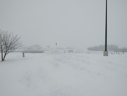
At least it's already Sunny and the winds have done a good job of quickly eroding the residual stratocumulus.
0 likes
Re: Texas Winter 2024-2025
Ntxw wrote:12z ICON is heavy snow for much of North Texas and parts of Central Texas.
With a bullseye near/just SW of DFW.
It's pretty similar-looking to the 06z GFS from Saturday morning.
2 likes

Re: Texas Winter 2024-2025
What is it looking like for OKC? Seems like the heavier precip will be in Texas, but hoping for a little something. We haven't had a significant snow in a few years.
1 likes
Who is online
Users browsing this forum: cheezyWXguy and 88 guests