
Uploaded with ImageShack.us
Moderator: S2k Moderators
 The posts in this forum are NOT official forecast and should not be used as such. They are just the opinion of the poster and may or may not be backed by sound meteorological data. They are NOT endorsed by any professional institution or STORM2K.


Portastorm wrote:Taking my moderator hat off and putting on my winter weather fandom hat ... and sharing some Saturday morning thoughts out of the Portastorm Weather Center:
1) The extensive dialogue over the last two weeks in this forum regarding Sudden Stratospheric Warming (SSW) has been educational, entertaining, and, at times, frustrating. Let's be honest with each other ... we're all amateurs and while some of us are more advanced than others, talking about SSW is like talking about nuclear physics. It's a VERY complicated topic which even degreed pro mets on other forums acknowledge a tall learning curve. We know a little bit about this subject, at best.
2) With that in mind, any calls here for a certain weather pattern to develop based on yours or my understanding of SSW are flawed at best. Unfortunately expectations get raised when we make those posts and then people get disappointed when it doesn't happen.
3) Yes, this is a forum for us to bandy about our various ideas, share humor, and otherwise comiserate or celebrate whatever weather the good Lord is allowing to happen. My thoughts here are not meant to discourage that. I would just encourage people to put a filter on your expectations if you're basing them on anything other than comments from a pro met here, the NWS, or a pro met whose word you trust. Sometimes us amateurs know what we're talking about ... more times, we know a little. If you allow your winter weather hopes to soar and plummet based on the daily dialogue here, it'll kill ya! Trust me, I know. I've died a thousand deaths over the years.
4) Yes, I still believe some major-league cold is coming down the pike. The polar vortex, or a piece of it, is progged by the GFS and the Euro to come down into Canada and maybe even the Great Lakes around Jan 20-22. If that happens, it's gonna get VERY COLD here. No doubt about it. I think the late January period into February is going to provide some real excitement for many of us. And as many here have already posted, February has provided some of our best winter weather events over the years.
5) This coming week’s storm system(s) look less impressive than a few days ago. There may be a smattering of wintry precip in the mornings in some select areas but probably nothing widespread.
6) And finally … personally, one of the great things about Storm2K is the ability for rank amateurs such as myself to talk weather with more educated amateurs and even professional meteorologists. We do so in an environment which is devoid of criticism. Hopefully that encourages lurkers and first timers to post questions and comments. Don’t stop, gang! Jump in.
 That will probably be almost as warm as we get the rest of the week. My guess is that this is the first step in the "step down" to the possible "extreme" cold we may see in the next several weeks.


dhweather wrote:It's sure looking like the EPAC ridge will break down in 5-7 days. For ease of use, look at the GFS/ECMWF/CMC and even NOGAPS: http://moe.met.fsu.edu/tcgengifs/
Looks like the ridge breaks down, and late some strong high pressure builds across Alaska, into western Canada, and starts heading south towards the upper plains/great lakes.

Ntxw wrote:Second run in a row from the GFS showing record U.S cold (yes vodka even into Texas). Not the range we want but it is a good building foundation to work with

BigB0882 wrote:Ntxw wrote:Second run in a row from the GFS showing record U.S cold (yes vodka even into Texas). Not the range we want but it is a good building foundation to work with
Is that map showing temps only at the time posted on the map or are those the high temps for that day? I forget how that works sometimes. I see the 0c line down to my area but it makes a big difference if it is a high temp or just the temp which might be in the middle of the night. A light freeze wouldn't be anything too exciting for my area but a high below freezing sure would be.

Portastorm wrote::uarrow:
Big O, if you are going to copy a post from someone, please indicate where you saw this and from where you are copying. Another forum? Please edit your post and give credit to where it's coming from. Thanks.
I'm quite familiar with Jorge (wxmx) and his stellar reputation as a very knowledgable amateur. I don't doubt at all what he's saying. He's one smart weather dude.


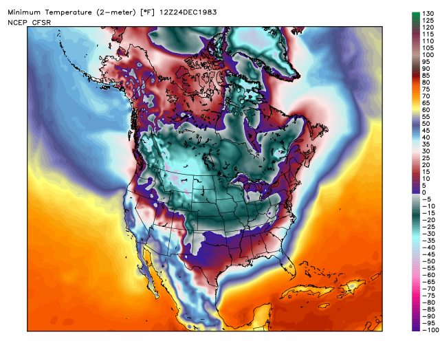
orangeblood wrote:If anyone wants to see what coast to coast Vodka Cold looks like, check out this NCEP reanalysis map from one of the coldest nights for the North American continent you'll ever find......the morning of December 24, 1983. Where the entire US temperature averaged out to be around 4 deg F!!!!

Users browsing this forum: Cpv17, Google Adsense [Bot], SnowyOwl31 and 96 guests


