HPC:
THE GLOBAL DETERMINISTIC AND ENSEMBLE GUIDANCE IS IN GOOD
AGREEMENT THAT A DEEP CYCLONE WILL BE SLOWLY PROGRESSING THROUGH
THE NORTHEAST PACIFIC...AND THAT A NEGATIVELY TILTED TROUGH WITH
AN EMBEDDED DEEP CYCLONE WILL LURK NEAR NEW ENGLAND AND ATLANTIC
CANADA THROUGH THE PERIOD /THE 00Z CANADIAN HAS ISSUES WITH THIS
LATTER SYSTEM DUE TO ITS UNIQUE SOLUTION IN CENTRAL CANADA EARLY
TO MID NEXT WEEK/.
THERE ARE PAIR OF FORECAST ISSUES EARLY THIS MORNING. THE FIRST
ISSUE REVOLVES AROUND A PACIFIC SHORTWAVE MOVING OVER THE TOP OF
THE BROAD/INCREASINGLY STRONG RIDGE CENTERED ACROSS THE SOUTHERN
STATES WHICH MOVES NEAR THE US/CANADIAN BORDER BEFORE DIVING
EAST-SOUTHEAST INTO THE MID-ATLANTIC STATES. THE 00Z CANADIAN/00Z
ECMWF MOVE THE SYSTEM THROUGH THE NORTH AND EAST ABOUT A DAY
QUICKER THAN THE 00Z GFS...AS THE GFS USES ADDITIONAL NORTHERN
STREAM ENERGY MOVING THROUGH WESTERN CANADA TO SLOW ITS PACE AS IT
MOVES THROUGH AN OTHERWISE QUICK QUASI-ZONAL/SUPERGEOSTROPHIC
FLOW. ALSO...BY THE TIME IS MOVES NEAR THE MID-ATLANTIC
STATES...THE GFS BRINGS 500 HPA HEIGHTS 4.5-5 STANDARD DEVIATIONS
BELOW NORMAL FOR THIS TIME OF THE YEAR BETWEEN CHARLESTON SC AND
JACKSONVILLE FL...WHICH IS IMPROBABLE. SINCE THE ECMWF ENSEMBLE
MEMBER TIMING HAS BEEN REASONABLY CONSISTENT OVER ITS PAST FEW
DAYS OF RUNS...AND INDICATE A QUICKER PROGRESSION...WILL CONTINUE
TO GO WITH THIS IDEA BY FAVORING A 00Z ECMWF-LIKE SOLUTION...WHICH
LOOKS MUCH MORE PLAUSIBLE THAN ITS PRIOR COUPLE DAYS OF RUNS.
THE SECOND ISSUE INVOLVES A POTENTIALLY CLOSED LOW MOVING THROUGH
THE SOUTHWEST...WHICH BOTH THE 00Z CANADIAN/00Z ECMWF ADVERTISE.
THE 00Z GFS HAS A CLOSED LOW WHICH IT DEVELOPS MUCH FARTHER
OFFSHORE THE SOUTHERN CALIFORNIA COAST...WHICH TAKES AN EXTRA
COUPLE DAYS TO GET INTO THE SOUTHWEST. THE GFS SOLUTION IS SLOWER
THAN THE EITHER CLUSTER OF THE BIMODAL 00Z GEFS MEAN AND MUCH
SLOWER THAN THE 12Z ECMWF ENSEMBLE MEAN SOLUTION. A SLOWLY
PROGRESSIVE NORTHERN STREAM RIDGE IN SOUTHWEST CANADA FAVORS A
PROGRESSIVE CLOSED CYCLONE 20 DEGREES UNDER ITS BASE MOVING
THROUGH THE SOUTHWEST...SO CONFIDENCE IS HIGHER THAN NORMAL IN ITS
EXISTENCE...BUT TIMING IS AN ISSUE...AS IS USUALLY THE CASE LATE
IN THE MEDIUM RANGE PERIOD. SINCE THE CLOSED MEMBERS OF THE 12Z
GEFS MEAN /USING 5520 METER 500 HPA HEIGHT LINE SPAGHETTIS/ WERE
IN LINE WITH A BULK OF THE 12Z ECMWF ENSEMBLE MEMBERS...AND THE
NORTHERN STREAM RIDGE IS ONLY SLOWLY PROGRESSIVE...THINK A QUICKER
PROGRESSION OF THE CLOSED LOW IS ADVISABLE...WHICH IS BEST IN LINE
WITH THE 00Z CANADIAN SOLUTION. THIS FITS INTO THE 00Z GEFS
MEAN/00Z ECMWF COMPROMISE PREFERENCE QUITE WELL.
Winter 2010-11 for the Southern Plains
Moderator: S2k Moderators
Forum rules
 The posts in this forum are NOT official forecast and should not be used as such. They are just the opinion of the poster and may or may not be backed by sound meteorological data. They are NOT endorsed by any professional institution or STORM2K.

The posts in this forum are NOT official forecast and should not be used as such. They are just the opinion of the poster and may or may not be backed by sound meteorological data. They are NOT endorsed by any professional institution or STORM2K.
-
srainhoutx

- S2K Supporter

- Posts: 6919
- Age: 68
- Joined: Sun Jan 14, 2007 11:34 am
- Location: Haywood County, NC
- Contact:
Re: Winter 2010-11 for the Southern Plains
0 likes
Carla/Alicia/Jerry(In The Eye)/Michelle/Charley/Ivan/Dennis/Katrina/Rita/Wilma/Ike/Harvey
Member: National Weather Association
Wx Infinity Forums
http://wxinfinity.com/index.php
Facebook.com/WeatherInfinity
Twitter @WeatherInfinity
Member: National Weather Association
Wx Infinity Forums
http://wxinfinity.com/index.php
Facebook.com/WeatherInfinity
Twitter @WeatherInfinity
-
WeatherGuesser
- Category 5

- Posts: 2672
- Joined: Tue Jun 29, 2010 6:46 am
Alright all you fortune tellers, what do your crystal balls tell you about the chances for another ice storm for the Ohio River Valley? We had two back to back in '07/'08 and '08/'09. One more and there won't be a whole lot of trees left. Damage was so bad in the way of broken branches and limbs in '09 we lost about 20' off the top of the canopy for hundreds of miles.
Improved cell phone service though , less branches and leaves to block signals.
Improved cell phone service though
0 likes
-
TwisterFanatic

- Category 5
- Posts: 1041
- Joined: Mon Jun 28, 2010 12:43 pm
- Location: Sallisaw, Oklahoma
Well, the Weatherchannel now has for next Tuesday SNOW for my town.
0 likes
Personal Forecast Disclaimer:
The posts in this forum are NOT official forecast and should not be used as such. They are just the opinion of the poster and may or may not be backed by sound meteorological data. They are NOT endorsed by any professional institution or storm2k.org. For official information, please refer to the NHC and NWS products.
The posts in this forum are NOT official forecast and should not be used as such. They are just the opinion of the poster and may or may not be backed by sound meteorological data. They are NOT endorsed by any professional institution or storm2k.org. For official information, please refer to the NHC and NWS products.
-
Extremeweatherguy

- Category 5
- Posts: 11095
- Joined: Mon Oct 10, 2005 8:13 pm
- Location: Florida
Re: Winter 2010-11 for the Southern Plains
The 00z GFS is the most bullish run for snowfall that we have seen in several days. It is showing snow breaking out across northern sections of the southern plains (Oklahoma, Texas panhandle, extreme north Texas) on Monday afternoon, and then lasting into early Tuesday...
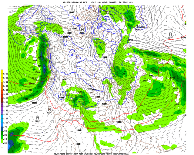
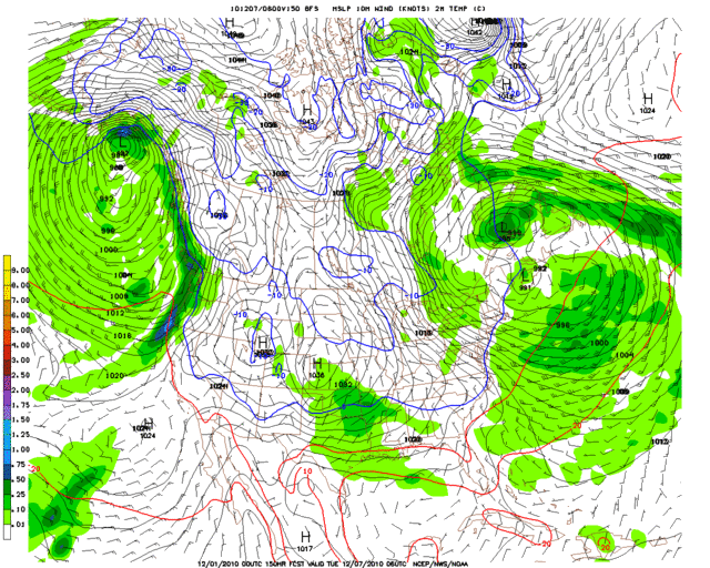
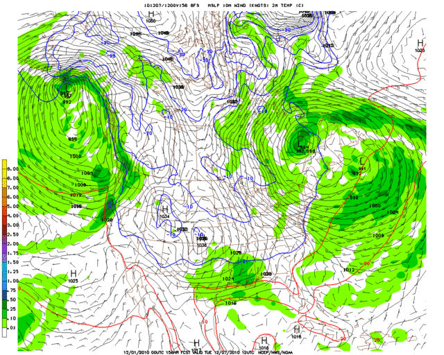
The blue line on these images is the surface freezing line. The 850mb (5000 ft) freezing line is located slightly further south, and the 540 thickness line is generally somewhere in between.
Snowfall accumulations at hour 156 (6am Tuesday morning):
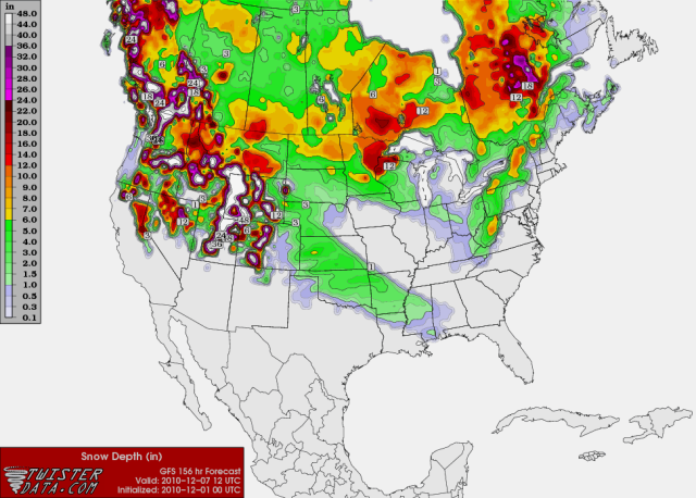
More than an inch of snow is shown over most of Oklahoma and into parts of extreme northeast Texas on this run, with over 3 inches across north-central Oklahoma up into Kansas. A dusting extends into areas slightly further south, including most of the Red River region.
The blue line on these images is the surface freezing line. The 850mb (5000 ft) freezing line is located slightly further south, and the 540 thickness line is generally somewhere in between.
Snowfall accumulations at hour 156 (6am Tuesday morning):
More than an inch of snow is shown over most of Oklahoma and into parts of extreme northeast Texas on this run, with over 3 inches across north-central Oklahoma up into Kansas. A dusting extends into areas slightly further south, including most of the Red River region.
0 likes
-
TwisterFanatic
- Category 5
- Posts: 1041
- Joined: Mon Jun 28, 2010 12:43 pm
- Location: Sallisaw, Oklahoma
Yea, its getting into that timeframe where the GFS should start coming back to reality instead of showing absolutely nothing. I do think the GFS is a little fast also.
0 likes
Personal Forecast Disclaimer:
The posts in this forum are NOT official forecast and should not be used as such. They are just the opinion of the poster and may or may not be backed by sound meteorological data. They are NOT endorsed by any professional institution or storm2k.org. For official information, please refer to the NHC and NWS products.
The posts in this forum are NOT official forecast and should not be used as such. They are just the opinion of the poster and may or may not be backed by sound meteorological data. They are NOT endorsed by any professional institution or storm2k.org. For official information, please refer to the NHC and NWS products.
-
Extremeweatherguy
- Category 5
- Posts: 11095
- Joined: Mon Oct 10, 2005 8:13 pm
- Location: Florida
As compared to the GFS, the 00z ECMWF doesn't look so good for winter precipitation...a big contrast to its earlier solutions.
The big difference in the ECMWF is that it holds back the upper level energy about 24 hours behind the GFS. It also doesn't show a very strong piece of 500mb energy by the time it reaches the southern plains, which is also a change from earlier runs**. With the ECMWF being 24 hours slower than GFS, the upper level energy misses the coldest air (which comes through late Sunday through early Tuesday on the ECMWF), meaning yet another negative.
All in all, it looks like the model wars continue. As one flips one way, the other goes another. Hopefully they will merge on a common solution regarding timing, system strength, etc by the end of this week.
** = It should be noted that the GFS doesn't really show a strong piece of 500mb energy either.
EDIT: Upon looking at the ECMWF text output, it actually does show 0.01" of liquid equivalent precipitation falling across parts of the region late Sunday night/early Monday morning in an atmosphere capable of supporting snow (specifically at OKC and OUN). 0.01" is laughable though, and would equate to only some flurries or a very very light dusting of snow if lucky. Definitely not enough to count as a "storm", and still far removed from the GFS solution, which shows closer to 0.30" of liquid equivalent precipitation (30 times the ECMWF!).
Last edited by Extremeweatherguy on Wed Dec 01, 2010 2:18 am, edited 2 times in total.
0 likes


Re:
Extremeweatherguy wrote:As compared to the GFS, the 00z ECMWF doesn't look so good for winter precipitation...a big contrast to its earlier solutions.
The big difference in the ECMWF is that it holds back the upper level energy about 24 hours behind the GFS. It also doesn't show a very strong piece of 500mb energy by the time it reaches the southern plains, which is also a change from earlier runs**. With the ECMWF being 24 hours slower than GFS, the upper level energy misses the coldest air (which comes through late Sunday through early Tuesday on the ECMWF), meaning yet another negative.
All in all, it looks like the model wars continue. As one flips one way, the other goes another. Hopefully they will merge on a common solution regarding timing, system strength, etc by the end of this week.
** = It should be noted that the GFS doesn't really show a strong piece of 500mb energy either.
It's so maddening
Edit: Tonight's theme is to shunt the cold air east, and kill off the shortwave coming into California.
Last edited by Ntxw on Wed Dec 01, 2010 2:14 am, edited 1 time in total.
0 likes
The above post and any post by Ntxw is NOT an official forecast and should not be used as such. It is just the opinion of the poster and may or may not be backed by sound meteorological data. It is NOT endorsed by any professional institution including Storm2k. For official information, please refer to NWS products.
Help support Storm2K!
-
TwisterFanatic
- Category 5
- Posts: 1041
- Joined: Mon Jun 28, 2010 12:43 pm
- Location: Sallisaw, Oklahoma
I hate model wars even though they're fun to watch. I remember last year the GFS and the NAM had a huge one going showing a 10" of snow difference with the NAM showing the least. The GFS ended up winning, and i had 14" of snow the next morning.
0 likes
Personal Forecast Disclaimer:
The posts in this forum are NOT official forecast and should not be used as such. They are just the opinion of the poster and may or may not be backed by sound meteorological data. They are NOT endorsed by any professional institution or storm2k.org. For official information, please refer to the NHC and NWS products.
The posts in this forum are NOT official forecast and should not be used as such. They are just the opinion of the poster and may or may not be backed by sound meteorological data. They are NOT endorsed by any professional institution or storm2k.org. For official information, please refer to the NHC and NWS products.
-
Extremeweatherguy
- Category 5
- Posts: 11095
- Joined: Mon Oct 10, 2005 8:13 pm
- Location: Florida
lol, to add to the current "model war" is the once consistent Canadian model. It had been showing a nice winter storm traversing north Texas and Oklahoma into Arkansas for the past several runs, but the latest 00z run has changed. It still keeps the upper level energy much stronger than the GFS and ECMWF, but it sends the center of the upper level low much further south; over south-central Texas and eventually into the Gulf. The cold air is lacking on this run though, so the precipitation associated with the storm would mainly be rain, perhaps mixing with sleet at times directly beneath the upper level low. The precipitation in this run is also shown staying south of the Oklahoma border.
0 likes
The Ensembles aren't much help either...absolutely all over the place. Every other plot has either a storm or no storm (both in the so-plains and California coast.)
0 likes
The above post and any post by Ntxw is NOT an official forecast and should not be used as such. It is just the opinion of the poster and may or may not be backed by sound meteorological data. It is NOT endorsed by any professional institution including Storm2k. For official information, please refer to NWS products.
Help support Storm2K!
Help support Storm2K!
-
Extremeweatherguy
- Category 5
- Posts: 11095
- Joined: Mon Oct 10, 2005 8:13 pm
- Location: Florida
Re: Winter 2010-11 for the Southern Plains
OUN morning discussion...
The last three paragraphs are the most important in regards to next weeks winter weather threat.
The last three paragraphs are the most important in regards to next weeks winter weather threat.
.PREV DISCUSSION... /ISSUED 433 AM CST WED DEC 1 2010/
DISCUSSION...SEASONABLY COOL WEATHER IN THE SHORT TERM...WITH LESS
WIND THAN THE PAST TWO DAYS. THEN A COLD FRONT ARRIVING SATURDAY IS
COMING INTO BETTER FOCUS....AND WILL MEAN SEVERAL DAYS OF COLD
WEATHER. THE POSSIBILITY OF A STORM SYSTEM TAKING SHAPE EARLY NEXT
WEEK STILL CARRIES AN UNUSUALLY LARGE AMOUNT OF UNCERTAINTY...BUT WE
HAVE TRENDED TOWARD A CHANCE OF LIGHT SNOW MONDAY AND TUESDAY.
EARLY MORNING SURFACE ANALYSIS SHOWED A FRONT PLUNGING INTO THE
GULF...AND EXCEPTIONALLY DRY AIR OVER MOST OF THE CONTINENTAL
INTERIOR. A BOUNDARY OF ARCTIC ORIGIN WAS STRETCHED ACROSS THE
CENTRAL PLAINS...AND PROGRESSING INTO THE SOUTHEAST STATES. THIS
BOUNDARY WILL STAY NORTH OF OUR FORECAST AREA...BUT A MID LEVEL WAVE
MOVING THROUGH THE BAROCLINIC ZONE WILL DRAG A TROUGH AND WIND SHIFT
INTO OUR REGION WEDNESDAY NIGHT. THIS WILL HAVE MINIMAL IMPACT ON
TEMPERATURE FORECASTS...AS THE AIR REMAINS TOO DRY FOR LOW CLOUD
FORMATION AND MID LEVELS WILL EXPERIENCE LARGER SCALE WARM ADVECTION
THROUGH FRIDAY. GENERALLY EXPECT LOWS AROUND OR JUST BELOW FREEZING
EACH NIGHT...AND HIGHS WARMING A BIT INTO THE 50S AND 60S EACH DAY.
THE MODELS ARE NOW IN BETTER AGREEMENT THAT A SHORT WAVE TROUGH IN
THE NORTHERN JET STREAM WILL CUT THROUGH RIDGING OVER THE WESTERN
U.S...AND BRING A COLD FRONT INTO THE PLAINS ON SATURDAY. COLD AIR
WILL THEN DEEPEN STEADILY THROUGH MONDAY AS THE SHORT WAVE HELPS TO
AMPLIFY THE LARGER SCALE TROUGH IN PLACE OVER THE EASTERN STATES...
WHICH IS HELD IN PLACE BY A STOUT OMEGA BLOCK IN THE NORTHERN
ATLANTIC. WHILE THIS STRETCH OF COLD WEATHER FROM SATURDAY TO MID
NEXT WEEK IS RELATIVELY CERTAIN...THE MODELS CONTINUE TO STRUGGLE
WITH THE EXACT TIMING OF THE FRONT AND EVENTUAL AMPLITUDE OF THE
EASTERN TROUGH. THE OPERATIONAL MODELS ARE ALSO WILDLY INCONSISTENT
WITH THEIR HANDLING OF AN IMPORTANT SOUTHERN STREAM TROUGH THAT MAY
OR MAY NOT CUT UNDER THE WESTERN U.S. RIDGE AND EMERGE OVER THE
SOUTHERN PLAINS NEXT WEEK. IN FOLLOWING THE TRENDS OF THE
OPERATIONAL AND ENSEMBLE RUNS...ALONG WITH HPC DISCUSSIONS...WE
CONTINUE IN FAVOR OF SOLUTIONS THAT LOOK LIKE YESTERDAYS 12Z ECMWF
AND TODAYS 00Z GFS ENSEMBLE PERTURBATION 10...WHICH BRING A SHORT
WAVELENGTH...PROGRESSIVE TROUGH INTO THE SOUTHERN PLAINS LATE MONDAY
INTO TUESDAY.
THE OPERATIONAL MODELS AND NOW THE ENSEMBLE MEMBERS INDICATE AIR
THAT IS COLD/DRY ENOUGH TO SUPPORT MAINLY LIGHT SNOW RATHER THAN
RAIN. WE INTRODUCED CHANCE POPS FOR LIGHT SNOW MONDAY NIGHT TO
TUESDAY...ESPECIALLY FOR AREAS SOUTH OF INTERSTATE 40...GIVEN THE
EXPECTED TRACK OF THE TROUGH. THE PATTERN FAVORS A PROGRESSIVE
SYSTEM...AND VERY DRY LOW LEVELS AT THE ONSET OF THE FORECAST
PRECIPITATION WOULD CERTAINLY HAMPER ITS ABILITY TO ACCUMULATE. AS
IT STANDS NOW...IT LOOKS AS THOUGH A WINTER ADVISORY EVENT COULD
OCCUR...BUT NOT LIKELY A SIGNIFICANT STORM. OF COURSE...GIVEN THE
UNUSUAL AMOUNT OF UNCERTAINTY...THE FORECAST MAY CHANGE QUITE A BIT
IN ONE DIRECTION OR ANOTHER BETWEEN NOW AND THEN.
ONE OTHER ITEM OF NOTE. ON SUNDAY AND EARLY MONDAY OUR REGION WILL
SIT BENEATH THE ENTRANCE REGION TO A WELL DEFINED UPPER JET...AND
THIS MAY SUPPORT BANDS OF LIGHT SNOW OR RAIN/SNOW MIX. THIS IS
REFLECTED IN THE MONDAY DAYTIME GRIDS...BUT COULD BEGIN EARLIER IN
NORTHERN OKLAHOMA.
0 likes
-
Extremeweatherguy
- Category 5
- Posts: 11095
- Joined: Mon Oct 10, 2005 8:13 pm
- Location: Florida
Re: Winter 2010-11 for the Southern Plains
The general trend, based on the 12z models, looks to be away from a significant winter storm early next week. It still looks to get pretty chilly though, and late Monday into Tuesday could feature periods of overcast skies and perhaps a few light snow/sleet showers north of the Red River. Scattered light accumulations cannot be ruled out either, but overall this is looking like a low-impact event based on the latest trends. There is still time for the models to change again though, so the situation is still worth keeping a very close eye on. By the end of the week we will probably have a very good idea of how this will all play out.
0 likes
My guess is the models will be doing a 180 a few more times before we have a clear picture. It's going to get cold that I'm fairly positive. 18z continues what the 12z trends have gone.
For long term interests, there's a large/strong area of disturbance very pronounced near Hawaii. This feature doesn't seem to be in the model's depiction very well. I suspect somewhere down the road (sooner than we may think), it will have big implications on weather around the country depending on how it traverses. It's strange to have such features being depicted in La Nina (el nino anyone?) years in these parts. Perhaps a pro met can further explain any connections?
The cold in Alaska is now on the move and spilling over into NW Canada with readings near -40 below along the border!!. Very large dome of cold air. The talk of a storm has somewhat neglected the air mass that could accompany it.
0 likes
The above post and any post by Ntxw is NOT an official forecast and should not be used as such. It is just the opinion of the poster and may or may not be backed by sound meteorological data. It is NOT endorsed by any professional institution including Storm2k. For official information, please refer to NWS products.
Help support Storm2K!
Help support Storm2K!
-
TwisterFanatic
- Category 5
- Posts: 1041
- Joined: Mon Jun 28, 2010 12:43 pm
- Location: Sallisaw, Oklahoma
Had a email conversation with the here meteorologist earlier, and he doesn't buy that there will be only little to no precip. He believes the wave is still way too far out to be sampled well by the models, and if something significant is going happen the model won't pick up on it for a couple more days. He says to take what the models say right now with a grain of salt.
0 likes
Personal Forecast Disclaimer:
The posts in this forum are NOT official forecast and should not be used as such. They are just the opinion of the poster and may or may not be backed by sound meteorological data. They are NOT endorsed by any professional institution or storm2k.org. For official information, please refer to the NHC and NWS products.
The posts in this forum are NOT official forecast and should not be used as such. They are just the opinion of the poster and may or may not be backed by sound meteorological data. They are NOT endorsed by any professional institution or storm2k.org. For official information, please refer to the NHC and NWS products.
-
TwisterFanatic
- Category 5
- Posts: 1041
- Joined: Mon Jun 28, 2010 12:43 pm
- Location: Sallisaw, Oklahoma
Re:
frigidice77 wrote:So your saying that their will be more precip with the storm next week?
Possible
0 likes
Personal Forecast Disclaimer:
The posts in this forum are NOT official forecast and should not be used as such. They are just the opinion of the poster and may or may not be backed by sound meteorological data. They are NOT endorsed by any professional institution or storm2k.org. For official information, please refer to the NHC and NWS products.
The posts in this forum are NOT official forecast and should not be used as such. They are just the opinion of the poster and may or may not be backed by sound meteorological data. They are NOT endorsed by any professional institution or storm2k.org. For official information, please refer to the NHC and NWS products.
0z GFS still isn't our friend as it continues to show a weak disturbance. Much colder run than previous with a strong high settling in the southern plains. Doesn't look friendly for frozen precip.
Maybe a little bit of snow for parts of eastern Oklahoma and Arkansas if the GFS is to be believed.

Maybe a little bit of snow for parts of eastern Oklahoma and Arkansas if the GFS is to be believed.
0 likes
The above post and any post by Ntxw is NOT an official forecast and should not be used as such. It is just the opinion of the poster and may or may not be backed by sound meteorological data. It is NOT endorsed by any professional institution including Storm2k. For official information, please refer to NWS products.
Help support Storm2K!
Help support Storm2K!
-
Extremeweatherguy
- Category 5
- Posts: 11095
- Joined: Mon Oct 10, 2005 8:13 pm
- Location: Florida
Re: Winter 2010-11 for the Southern Plains
Yeah, the 00z GFS continues the trend of the 12z runs in showing only a minor winter event for Oklahoma, perhaps just enough for a winter weather advisory in a few areas. As stated earlier though, further changes are likely, and a trend toward wetter/drier in the coming days is certainly possible. Regardless of precipitation though, the cold is definitely coming; and this could easily be our chilliest airmass of the season.
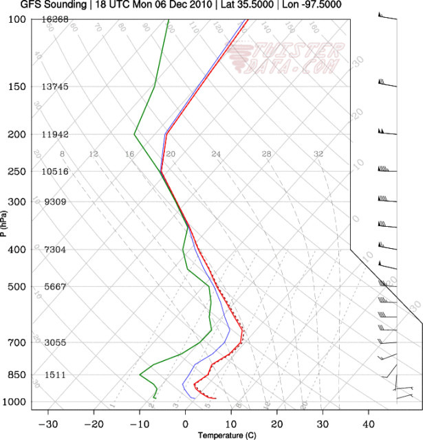
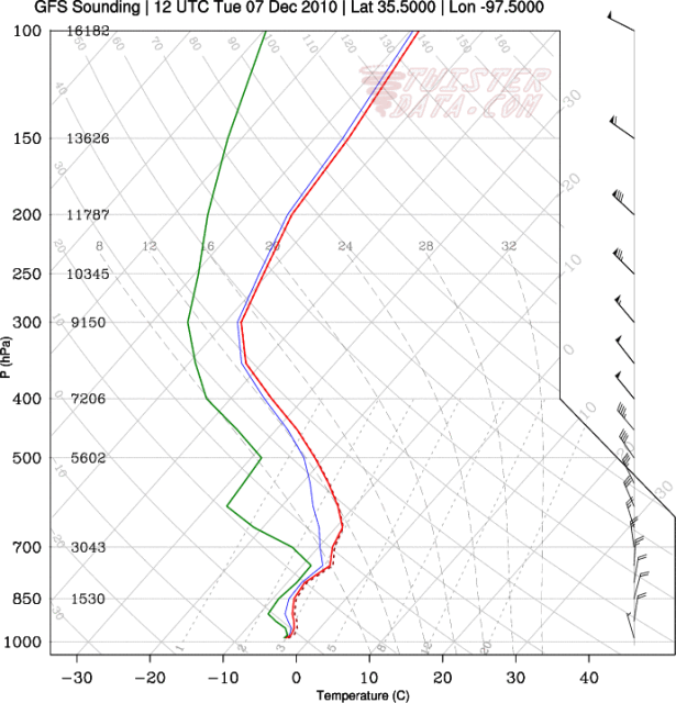
Just for fun, I have posted the skew-T/log-P output of the 00z GFS for the Oklahoma City region below (and briefly analyzed it). This is what central Oklahoma would experience "if" tonight's GFS run played out exactly. Take it with a grain of salt though, because as mentioned above, further changes are quite possible.
12pm Monday
http://i43.photobucket.com/albums/e371/ ... 75000W.png
Increasing upper level clouds, with a surface temperature close to 40F. Light surface winds out of the E/ENE and no precipitation.
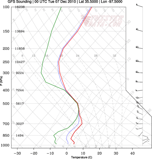
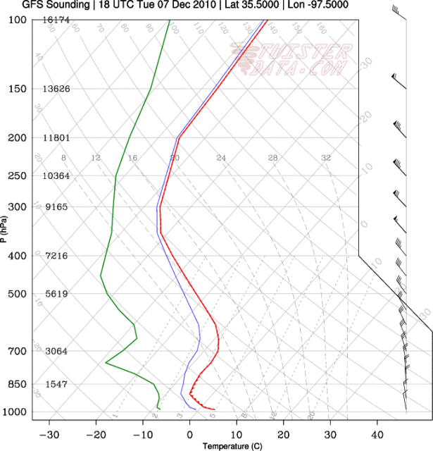
6pm Monday
http://i43.photobucket.com/albums/e371/ ... 75000W.png
Mid to upper level cloudiness continuing to increase. Surface temperature in the mid 30s. Surface winds out of the NE. Might be some flurries around the region, but the surface is too dry for precipitation at this particular sounding location.
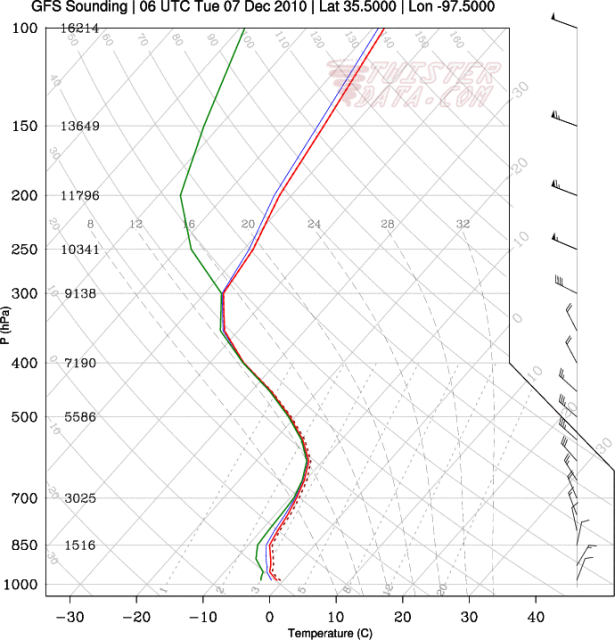
12am Tuesday
http://i43.photobucket.com/albums/e371/ ... 75000W.png
Overcast with a surface temperature just below freezing. The entire atmospheric column is also below freezing. Surface winds increasing out of NNE. The sounding is fairly saturated here, so snow would be falling at this time.
6am Tuesday
http://i43.photobucket.com/albums/e371/ ... 75000W.png
Clouds breaking with a surface temperature in the mid 20s. Surface winds generally out of a N/NNW direction. Snow has ended.
12pm Tuesday
http://i43.photobucket.com/albums/e371/ ... 75000W.png
Mostly sunny skies with a surface temperature in the mid 30s. Surface winds out of the NNW. No precipitation.
Just for fun, I have posted the skew-T/log-P output of the 00z GFS for the Oklahoma City region below (and briefly analyzed it). This is what central Oklahoma would experience "if" tonight's GFS run played out exactly. Take it with a grain of salt though, because as mentioned above, further changes are quite possible.
12pm Monday
http://i43.photobucket.com/albums/e371/ ... 75000W.png
Increasing upper level clouds, with a surface temperature close to 40F. Light surface winds out of the E/ENE and no precipitation.
6pm Monday
http://i43.photobucket.com/albums/e371/ ... 75000W.png
Mid to upper level cloudiness continuing to increase. Surface temperature in the mid 30s. Surface winds out of the NE. Might be some flurries around the region, but the surface is too dry for precipitation at this particular sounding location.
12am Tuesday
http://i43.photobucket.com/albums/e371/ ... 75000W.png
Overcast with a surface temperature just below freezing. The entire atmospheric column is also below freezing. Surface winds increasing out of NNE. The sounding is fairly saturated here, so snow would be falling at this time.
6am Tuesday
http://i43.photobucket.com/albums/e371/ ... 75000W.png
Clouds breaking with a surface temperature in the mid 20s. Surface winds generally out of a N/NNW direction. Snow has ended.
12pm Tuesday
http://i43.photobucket.com/albums/e371/ ... 75000W.png
Mostly sunny skies with a surface temperature in the mid 30s. Surface winds out of the NNW. No precipitation.
0 likes
-
Extremeweatherguy
- Category 5
- Posts: 11095
- Joined: Mon Oct 10, 2005 8:13 pm
- Location: Florida
The 00z ECMWF is showing 0.10" of liquid equivalent precipitation falling on OKC between late Monday evening and Tuesday morning (same timeframe of GFS precipitation). The ECMWF is a little warmer than the GFS though, and seems to keep the cold air shallower in nature over the southern plains. It sends the coldest upper-level air just to our east, meaning only marginal thicknesses and temperatures are in place during the precipitation. Because of this, the precipitation in this particular run would likely be in the form of a light wintry mix instead of just plain snow as the GFS is showing.
The 00z CMC is also targeting Monday evening into Tuesday morning for light precipitation across Oklahoma. It is leaning more towards the GFS in terms of cold air though, so this would mostly fall in the form of snow...

The 00z CMC is also targeting Monday evening into Tuesday morning for light precipitation across Oklahoma. It is leaning more towards the GFS in terms of cold air though, so this would mostly fall in the form of snow...
Last edited by Extremeweatherguy on Thu Dec 02, 2010 2:03 am, edited 3 times in total.
0 likes
As hard as it is for me to say this, but basically the globals and ensembles have diverged on a general solution less than a week now out, (minus the finer details) which usually means that's how it will likely end up. Barring something major to change, doesn't look like a significant winter storm is brewing for the southern plains...hope I am dead wrong.
*Insignificant note: Euro is barking at another storm late next weekend, but I've been burned enough this week to take that without any meaning
*Insignificant note: Euro is barking at another storm late next weekend, but I've been burned enough this week to take that without any meaning
0 likes
The above post and any post by Ntxw is NOT an official forecast and should not be used as such. It is just the opinion of the poster and may or may not be backed by sound meteorological data. It is NOT endorsed by any professional institution including Storm2k. For official information, please refer to NWS products.
Help support Storm2K!
Help support Storm2K!
Who is online
Users browsing this forum: No registered users and 52 guests