Texas Winter 2012-2013

Winter Weather Discussion

Moderator: S2k Moderators

Forum rules

The posts in this forum are NOT official forecast and should not be used as such. They are just the opinion of the poster and may or may not be backed by sound meteorological data. They are NOT endorsed by any professional institution or STORM2K.

Help Support Storm2K
Message
Author
User avatar
Ntxw
Storm2k Moderator
Storm2k Moderator
Posts: 22787
Joined: Wed Oct 21, 2009 6:34 pm
Location: DFW, Texas

Re: Texas Winter 2012-2013

#3321 Postby Ntxw » Mon Jan 21, 2013 3:13 pm

wxman57 wrote:Of course, that MJO long-range forecast is made by the same model that many have said can't be trusted even out to next week - the GFS. If you can't believe it as far as next week's general warmth in Texas, you can't believe it's MJO forecast.


You are right sir! But that is mostly true when the MJO is incoherent. Not completely true when there is a defined wave even without the models one can conclude that there is a pretty good chance it propagates in principle alone. The models are probably wrong on intensity though currently.

***
Snippet from the HPC today

IN THE WEST... A DEEP UPPER LOW IN THE LOW LATITUDES WELL SW OF
CALIFORNIA IN THE SHORT TERM WILL GRADUALLY FILL AND MOVE INTO THE
SW STATES. THE GEFS ENSEMBLE MEMBERS ARE GENERALLY QUICKER THAN
THE ECMWF MEMBERS TO MOVE THIS WEAKENING SYSTEM INLAND... WHICH
GENERALLY FIT THEIR BIASES. PREFER TO SIDE WITH THE SLOWER ECMWF
SOLUTION BASED ON BETTER VERIFICATION OF SW CLOSED LOWS WITH THE
ECMWF ENSEMBLES OVER THE GEFS ENSEMBLES. RELATIVE MEASURE OF
PREDICTABILITY VALUES PER THE GEFS MEMBERS WERE VERY LOW NEAR
SOUTHERN CALIFORNIA EARLY NEXT WEEK INDICATING LOW CONFIDENCE
WITHIN THE GEFS SYSTEM. ON THE CONTRARY... THE NORMALIZED STANDARD
DEVIATION AMONG THE ECMWF ENSEMBLES IMPLIED BETTER THAN AVERAGE
/30 DAYS OF RUNS/ PREDICTABILITY IN THE SAME LOCATION. THIS
SEPARATION SHOULD SLOWLY RESOLVE ITSELF OVER TIME AND GENERALLY
WOULD SEE A SHIFT IN THE GUIDANCE ONCE IT IT GETS WITHIN SEVERAL
DAYS OUT /F132 OR SO/. INTERESTING TO NOTE THAT THE 00Z CANADIAN
LIED SQUARELY IN BETWEEN THE GEFS AND ECENS MEANS. THE EFFECT
DOWNSTREAM OF A SLOWER MOVEMENT OF THE UPPER LOW EASTWARD INTO THE
SW WOULD BE LOWER HEIGHTS IN THE EAST WITH MORE NORTHERN STREAM
FLOW.


FRACASSO
0 likes   
The above post and any post by Ntxw is NOT an official forecast and should not be used as such. It is just the opinion of the poster and may or may not be backed by sound meteorological data. It is NOT endorsed by any professional institution including Storm2k. For official information, please refer to NWS products.

  Help support Storm2K!
Help Support Storm2K

User avatar
wxman57
Moderator-Pro Met
Moderator-Pro Met
Posts: 22980
Age: 67
Joined: Sat Jun 21, 2003 8:06 pm
Location: Houston, TX (southwest)

Re: Texas Winter 2012-2013

#3322 Postby wxman57 » Mon Jan 21, 2013 3:16 pm

Ntxw wrote:
wxman57 wrote:Of course, that MJO long-range forecast is made by the same model that many have said can't be trusted even out to next week - the GFS. If you can't believe it as far as next week's general warmth in Texas, you can't believe it's MJO forecast.


You are right sir! But that is mostly true when the MJO is incoherent. Not completely true when there is a defined wave even without the models one can conclude that there is a pretty good chance it propagates in principle alone. The models are probably wrong on intensity though currently.

***
Snippet from the HPC today

IN THE WEST... A DEEP UPPER LOW IN THE LOW LATITUDES WELL SW OF
CALIFORNIA IN THE SHORT TERM WILL GRADUALLY FILL AND MOVE INTO THE
SW STATES. THE GEFS ENSEMBLE MEMBERS ARE GENERALLY QUICKER THAN
THE ECMWF MEMBERS TO MOVE THIS WEAKENING SYSTEM INLAND... WHICH
GENERALLY FIT THEIR BIASES. PREFER TO SIDE WITH THE SLOWER ECMWF
SOLUTION BASED ON BETTER VERIFICATION OF SW CLOSED LOWS WITH THE
ECMWF ENSEMBLES OVER THE GEFS ENSEMBLES. RELATIVE MEASURE OF
PREDICTABILITY VALUES PER THE GEFS MEMBERS WERE VERY LOW NEAR
SOUTHERN CALIFORNIA EARLY NEXT WEEK INDICATING LOW CONFIDENCE
WITHIN THE GEFS SYSTEM. ON THE CONTRARY... THE NORMALIZED STANDARD
DEVIATION AMONG THE ECMWF ENSEMBLES IMPLIED BETTER THAN AVERAGE
/30 DAYS OF RUNS/ PREDICTABILITY IN THE SAME LOCATION. THIS
SEPARATION SHOULD SLOWLY RESOLVE ITSELF OVER TIME AND GENERALLY
WOULD SEE A SHIFT IN THE GUIDANCE ONCE IT IT GETS WITHIN SEVERAL
DAYS OUT /F132 OR SO/. INTERESTING TO NOTE THAT THE 00Z CANADIAN
LIED SQUARELY IN BETWEEN THE GEFS AND ECENS MEANS. THE EFFECT
DOWNSTREAM OF A SLOWER MOVEMENT OF THE UPPER LOW EASTWARD INTO THE
SW WOULD BE LOWER HEIGHTS IN THE EAST WITH MORE NORTHERN STREAM
FLOW.


FRACASSO


What I see on that MJO forecast (image above) is a general trend toward a weakening, non-progressive MJO signal right up until the GFS takes over and forecasts it to suddenly strengthen and progress eastward. We'll see.
0 likes   

User avatar
Ntxw
Storm2k Moderator
Storm2k Moderator
Posts: 22787
Joined: Wed Oct 21, 2009 6:34 pm
Location: DFW, Texas

#3323 Postby Ntxw » Mon Jan 21, 2013 3:26 pm

Here's a forecast you will like wxman57, CFSv2 went complete 180 from yesterday to warmth in Feb :lol:

http://origin.cpc.ncep.noaa.gov/product ... /cfs_fcst/
0 likes   
The above post and any post by Ntxw is NOT an official forecast and should not be used as such. It is just the opinion of the poster and may or may not be backed by sound meteorological data. It is NOT endorsed by any professional institution including Storm2k. For official information, please refer to NWS products.


  Help support Storm2K!

Help Support Storm2K


User avatar
Portastorm
Storm2k Moderator
Storm2k Moderator
Posts: 9914
Age: 63
Joined: Fri Jul 11, 2003 9:16 am
Location: Round Rock, TX
Contact:

Re: Texas Winter 2012-2013

#3324 Postby Portastorm » Mon Jan 21, 2013 3:33 pm

wxman57 wrote:What I see on that MJO forecast (image above) is a general trend toward a weakening, non-progressive MJO signal right up until the GFS takes over and forecasts it to suddenly strengthen and progress eastward. We'll see.


I can see someone had a helping of hater tots and washed it down with some hater-aid over lunch! :wink:

Sure, the MJO forecast we've been discussing is based off of a GFS forecast but doesn't one have to grant it a little more credit when you look at the ensemble means in that forecast? Furthermore, the link below will take folks to the discussion about the MJO and where it may be headed. The experts at the Climate Prediction Center believe the MJO will continue to propogate eastward into our realm of the globe with a "moderate" strength.

http://www.cpc.ncep.noaa.gov/products/precip/CWlink/MJO/mjoupdate.pdf
0 likes   
Any forecasts under my name are to be taken with a grain of salt. Get your best forecasts from the National Weather Service and National Hurricane Center.

User avatar
TeamPlayersBlue
Category 5
Category 5
Posts: 3445
Joined: Tue Feb 02, 2010 1:44 am
Location: Denver/Applewood, CO

#3325 Postby TeamPlayersBlue » Mon Jan 21, 2013 3:44 pm

Isnt the MJO fairly easy to predict though? Amiright?
0 likes   
Personal Forecast Disclaimer:
The posts in this forum are NOT official forecast and should not be used as such. They are just the opinion of the poster and may or may not be backed by sound meteorological data. They are NOT endorsed by any professional institution or storm2k.org. For official information, please refer to the NHC and NWS products.

orangeblood
S2K Supporter
S2K Supporter
Posts: 3714
Joined: Tue Dec 15, 2009 6:14 pm
Location: Fort Worth, TX

Re: Texas Winter 2012-2013

#3326 Postby orangeblood » Mon Jan 21, 2013 4:04 pm

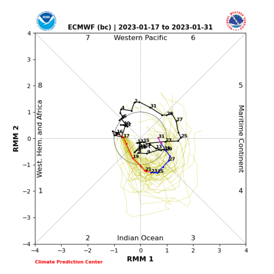
Euro MJO ensembles are in fairly good agreement with the GFS, just not as intense of a wave

Image

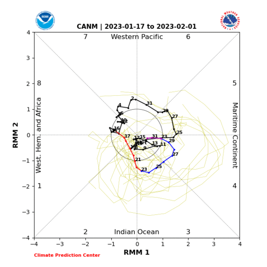
Canadian, on the other hand, is all over the place

Image
0 likes   

Yukon Cornelius
S2K Supporter
S2K Supporter
Posts: 1798
Age: 41
Joined: Thu Dec 20, 2012 9:23 pm
Location: Dean, TX/Westcliffe, CO

#3327 Postby Yukon Cornelius » Mon Jan 21, 2013 4:28 pm

Hello winter? Where did you go?
0 likes   
#neversummer

User avatar
vbhoutex
Storm2k Executive
Storm2k Executive
Posts: 29113
Age: 73
Joined: Wed Oct 09, 2002 11:31 pm
Location: Cypress, TX
Contact:

Re:

#3328 Postby vbhoutex » Mon Jan 21, 2013 6:09 pm

Yukon Cornelius wrote:Hello winter? Where did you go?

About 300 miles North of you.
0 likes   
Skywarn, C.E.R.T.
Please click below to donate to STORM2K to help with the expenses of keeping the site going:
Image

User avatar
wxman57
Moderator-Pro Met
Moderator-Pro Met
Posts: 22980
Age: 67
Joined: Sat Jun 21, 2003 8:06 pm
Location: Houston, TX (southwest)

Re:

#3329 Postby wxman57 » Mon Jan 21, 2013 8:12 pm

Ntxw wrote:Here's a forecast you will like wxman57, CFSv2 went complete 180 from yesterday to warmth in Feb :lol:

http://origin.cpc.ncep.noaa.gov/product ... /cfs_fcst/


I choose to believe that forecast. Thanks!
0 likes   

User avatar
Ntxw
Storm2k Moderator
Storm2k Moderator
Posts: 22787
Joined: Wed Oct 21, 2009 6:34 pm
Location: DFW, Texas

Re:

#3330 Postby Ntxw » Mon Jan 21, 2013 9:39 pm

TeamPlayersBlue wrote:Isnt the MJO fairly easy to predict though? Amiright?


The MJO is a different animal once it reaches the western hemisphere. Land masses like NA and SA get in the way so it weakens without the big open water like the IO and PAC. It may stay intact it may not and it may even jump over into Africa. That is where models can overdo its strength, the bigger the wave the better chance it has.

Edit: I found a great site from the Australian bureau of Meteorology that has archived information of the MJO. We can go back and see what phases our favorite winter events occurred. It goes back to the 1970s.

http://www.bom.gov.au/climate/mjo/
0 likes   
The above post and any post by Ntxw is NOT an official forecast and should not be used as such. It is just the opinion of the poster and may or may not be backed by sound meteorological data. It is NOT endorsed by any professional institution including Storm2k. For official information, please refer to NWS products.


  Help support Storm2K!

Help Support Storm2K


User avatar
wxman57
Moderator-Pro Met
Moderator-Pro Met
Posts: 22980
Age: 67
Joined: Sat Jun 21, 2003 8:06 pm
Location: Houston, TX (southwest)

Re: Texas Winter 2012-2013

#3331 Postby wxman57 » Tue Jan 22, 2013 8:13 am

I'm really liking the 06Z GFS forecast for Houston over the next week. It matches what the Euro has been forecasting as far as 850mb and surface temps:

Image
0 likes   

orangeblood
S2K Supporter
S2K Supporter
Posts: 3714
Joined: Tue Dec 15, 2009 6:14 pm
Location: Fort Worth, TX

Re: Texas Winter 2012-2013

#3332 Postby orangeblood » Tue Jan 22, 2013 9:37 am

:uarrow: wxman57 - it appears that the heat misers are winning at halftime of the winter season and by a pretty substantial margin (over 4 degrees above normal for most of Texas). So it's going to take quite a turnaround in order for you to blow this lead....
0 likes   

User avatar
Portastorm
Storm2k Moderator
Storm2k Moderator
Posts: 9914
Age: 63
Joined: Fri Jul 11, 2003 9:16 am
Location: Round Rock, TX
Contact:

Re: Texas Winter 2012-2013

#3333 Postby Portastorm » Tue Jan 22, 2013 9:53 am

My goodness does the 0z Euro ensemble means look cold and stormy for much of the Plains/Texas in about 8-9 days!

Image

Uploaded with ImageShack.us

Image

Uploaded with ImageShack.us


And even the experts are throwing out the GFS op runs as being useless and going with King Euro and his ensembles. Read on:

EXTENDED FORECAST DISCUSSION
NWS HYDROMETEOROLOGICAL PREDICTION CENTER COLLEGE PARK MD
204 AM EST TUE JAN 22 2013

VALID 12Z FRI JAN 25 2013 - 12Z TUE JAN 29 2013

...BECOMING WETTER ACROSS THE WEST...
...WINTER STORM AND COLD IN THE EAST...

MODELS CONTINUE TO HAVE ABOVE AVERAGE DIFFICULTY IN RESOLVING THE
FINE DETAILED STRUCTURE OF THE SPLIT UPPER TROUGH BETWEEN HAWAII
AND THE WEST COAST AND THE UPPER VORTEX NEAR HUDSON BAY...BASED ON
HIGHER THAN USUAL SPREAD AND LACK OF RUN-TO-RUN CONTINUITY WITH
HOW THEY INTERACT WITH ONE ANOTHER IN THE MEDIUM RANGE PERIOD.
THESE CONSIDERATIONS GENERALLY RESULT IN BELOW AVERAGE CONFIDENCE
IN THE DAY-TO-DAY DETAILS FOR NEARLY ALL AREAS EXCEPT FOR PERHAPS
FLORIDA...WITH A EMPHASIS TOWARD THE 12Z ECMWF ENSEMBLE MEAN
ACROSS THE WEST...AND A 12Z ECMWF ENSEMBLE MEAN/18Z GEFS MEAN
COMPROMISE ACROSS THE EAST.

ACROSS THE WEST...THE 00Z GFS WAS ABANDONED ON DAYS
3-4/FRI-SAT...DUE TO RAPID PROGRESSION AND POOR MODEL SUPPORT FOR
NORTHERN PORTIONS OF THE SPLIT UPPER TROUGH MOVING INLAND. AT
LEAST THROUGH SATURDAY...THERE WAS NEARLY EQUAL AGREEMENT FOR AN
ECMWF ENSEMBLE MEAN/GEFS MEAN MIX...WITH THE GEFS SLIGHTLY FASTER
BUT NOT UNREASONABLE. HOWEVER...BEGINNING DAY 5/SUN...THE
AMPLIFYING NATURE OF THE UPPER TROUGH FAVORS A SLOWER
SCENARIO...WHICH A MAJORITY OF SOLUTIONS SHOW. THUS...HAVE
SWITCHED TO AN ECMWF ENSEMBLE MEAN FROM SUNDAY ONWARD. IF THE
OPERATIONAL 12Z ECMWF/12Z CANADIAN VERIFY....WHICH ARE SLOWER AND
MORE AMPLIFIED...A MORE CONCENTRATED REGION OF RAINFALL WILL
INFLUENCE CALIFORNIA AND THE INTERMOUNTAIN WEST THAN CURRENTLY
FORECAST...WHICH IS BASED MORE ON THE ENSEMBLE MEANS.

ACROSS THE EAST...USED A COMBINATION OF THE 18Z GEFS MEAN/00Z
(YESTERDAY) UKMET FOR THE LOW MOVING TOWARD THE OHIO VALLEY ON
FRIDAY...WITH THE SLOWER 12Z ECMWF AND FASTER 12Z GFS FURTHER FROM
THE CONSENSUS BUT STILL PLAUSIBLE SOLUTIONS. THE LARGE ARRAY OF
SOLUTIONS APPEARS PARTIALLY RELATED TO HOW NORTHERN STREAM FLOW
CROSSING THE GREAT LAKES INTERACTS WITH THE APPROACHING SYSTEM.
BY FRIDAY NIGHT...THE LOW SHOULD BEGIN TO REFORM NEAR THE
BAROCLINIC ZONE OVER THE CAROLINA PIEDMONT BEFORE CONSOLIDATING
WITH THE PARENT LOW NEAR THE NORTHEAST COAST. THE SUBFREEZING
ANTECEDENT CONDITIONS AHEAD OF THE LOW'S APPROACH FAVORS A
SIGNIFICANT SWATH OF FREEZING AND FROZEN PRECIPITATION...WITH THE
TIMING/AMOUNTS STILL SOMEWHAT UNCLEAR BASED ON THE LARGE SOLUTION
SPREAD...BUT PRESENTLY APPEARS MOST LIKELY FROM THE TENNESSEE
RIVER VALLEY/APPALACHIANS/CAROLINA FOOTHILLS AND PIEDMONT
NORTHWARD INTO NEW ENGLAND FRIDAY AND SATURDAY.

JAMES
0 likes   
Any forecasts under my name are to be taken with a grain of salt. Get your best forecasts from the National Weather Service and National Hurricane Center.

orangeblood
S2K Supporter
S2K Supporter
Posts: 3714
Joined: Tue Dec 15, 2009 6:14 pm
Location: Fort Worth, TX

Re: Texas Winter 2012-2013

#3334 Postby orangeblood » Tue Jan 22, 2013 10:24 am

Unfortunately, looking at the latest Stratospheric forecast, it appears the window is closing for any severe sustained cold as the Polar Vortex split is now forecast to consolidate back into one PV over much higher latitudes in the 8-10 day period. The SSW did some damage to the PV but it doesn't look like it will last too much longer. Majority of the severe cold caused by the latest SSW is staying off to the northeast of us

Image


The following post is NOT an official forecast and should not be used as such. It is just the opinion of the poster and may or may not be backed by sound meteorological data. It is NOT endorsed by any professional institution including storm2k.org. For official information, please refer to NWS products.
0 likes   

User avatar
Ntxw
Storm2k Moderator
Storm2k Moderator
Posts: 22787
Joined: Wed Oct 21, 2009 6:34 pm
Location: DFW, Texas

#3335 Postby Ntxw » Tue Jan 22, 2013 12:38 pm

^ I don't see it, that looks to me like the lower strat is being attacked and you see three vorts. There is no consolidation in the upper levels (30-70hpa) are thoroughly destroyed, top down event.

We go through this every year even 2010 and 2011 late Jan. Last year even had a slight turn around in Feb, don't call the end game until every quarter is played!
0 likes   
The above post and any post by Ntxw is NOT an official forecast and should not be used as such. It is just the opinion of the poster and may or may not be backed by sound meteorological data. It is NOT endorsed by any professional institution including Storm2k. For official information, please refer to NWS products.


  Help support Storm2K!

Help Support Storm2K


orangeblood
S2K Supporter
S2K Supporter
Posts: 3714
Joined: Tue Dec 15, 2009 6:14 pm
Location: Fort Worth, TX

Re:

#3336 Postby orangeblood » Tue Jan 22, 2013 1:10 pm

Ntxw wrote:^ I don't see it, that looks to me like the lower strat is being attacked and you see three vorts. There is no consolidation in the upper levels (30-70hpa) are thoroughly destroyed, top down event.

We go through this every year even 2010 and 2011 late Jan. Last year even had a slight turn around in Feb, don't call the end game until every quarter is played!


Not calling the end of winter by any means but we need a heck of a sustained cold snap just to get back to normal for the winter....somewhere in the magnitude of 4-5 deg below normal from here on out. If you look at the numbers, temp wise we are right where we were last year up to this point with the only difference being a little more snow. Hopefully, February makes a big turn!!
0 likes   

User avatar
CaptinCrunch
S2K Supporter
S2K Supporter
Posts: 8728
Age: 57
Joined: Mon Nov 03, 2003 4:33 pm
Location: Kennedale, TX (Tarrant Co.)

#3337 Postby CaptinCrunch » Tue Jan 22, 2013 1:36 pm

Feburary is going to be cold the first half, then warm up and then cold going into March before spring takes over in late March.

Trust me..... :ggreen:
0 likes   

User avatar
Tireman4
S2K Supporter
S2K Supporter
Posts: 5853
Age: 59
Joined: Fri Jun 30, 2006 1:08 pm
Location: Humble, Texas
Contact:

Re:

#3338 Postby Tireman4 » Tue Jan 22, 2013 1:43 pm

Ntxw wrote:^ I don't see it, that looks to me like the lower strat is being attacked and you see three vorts. There is no consolidation in the upper levels (30-70hpa) are thoroughly destroyed, top down event.

We go through this every year even 2010 and 2011 late Jan. Last year even had a slight turn around in Feb, don't call the end game until every quarter is played!


Yeah but Wxman57 said "Winter cancel"...LOL
0 likes   

User avatar
Ntxw
Storm2k Moderator
Storm2k Moderator
Posts: 22787
Joined: Wed Oct 21, 2009 6:34 pm
Location: DFW, Texas

Re:

#3339 Postby Ntxw » Tue Jan 22, 2013 1:43 pm

CaptinCrunch wrote:Feburary is going to be cold the first half, then warm up and then cold going into March before spring takes over in late March.

Trust me..... :ggreen:


Someone's been peeping in PWC's secret analog box!
0 likes   
The above post and any post by Ntxw is NOT an official forecast and should not be used as such. It is just the opinion of the poster and may or may not be backed by sound meteorological data. It is NOT endorsed by any professional institution including Storm2k. For official information, please refer to NWS products.


  Help support Storm2K!

Help Support Storm2K


User avatar
Ntxw
Storm2k Moderator
Storm2k Moderator
Posts: 22787
Joined: Wed Oct 21, 2009 6:34 pm
Location: DFW, Texas

Re: Re:

#3340 Postby Ntxw » Tue Jan 22, 2013 1:55 pm

Tireman4 wrote:
Ntxw wrote:^ I don't see it, that looks to me like the lower strat is being attacked and you see three vorts. There is no consolidation in the upper levels (30-70hpa) are thoroughly destroyed, top down event.

We go through this every year even 2010 and 2011 late Jan. Last year even had a slight turn around in Feb, don't call the end game until every quarter is played!


Yeah but Wxman57 said "Winter cancel"...LOL


I canceled winter earlier this month, it snowed/sleeted in dfw a week later. Now it's wxman's turn, he just jinxed himself :ggreen:
0 likes   
The above post and any post by Ntxw is NOT an official forecast and should not be used as such. It is just the opinion of the poster and may or may not be backed by sound meteorological data. It is NOT endorsed by any professional institution including Storm2k. For official information, please refer to NWS products.


  Help support Storm2K!

Help Support Storm2K


Return to “Winter Weather”

Who is online

Users browsing this forum: No registered users and 11 guests