Texas Winter 2016-2017

Winter Weather Discussion

Moderator: S2k Moderators

Forum rules

The posts in this forum are NOT official forecast and should not be used as such. They are just the opinion of the poster and may or may not be backed by sound meteorological data. They are NOT endorsed by any professional institution or STORM2K.

Help Support Storm2K
Message
Author
User avatar
northjaxpro
S2K Supporter
S2K Supporter
Posts: 8900
Joined: Mon Sep 27, 2010 11:21 am
Location: Jacksonville, FL

Re: Texas Winter 2016-2017

#3701 Postby northjaxpro » Fri Jan 13, 2017 9:10 pm

TeamPlayersBlue wrote:Wow, im surprised you get that many freezes there. We have had 3 so far in SW Houston.


Well, I am in the Jacksonville /Northern Jax area in Northeast Florida. Yes, we get our fair share of freezes here, but my.point in the previous post is that the average number of freezes has reduced considerably over the past six years . The Big Bend region and the Panhandle areas typically get a few more freezes than here in Northeast Florida because of the moderating influence at times when the surface winds become onshore from the Atlantic.
0 likes   
NEVER, EVER SAY NEVER in the tropics and weather in general, and most importantly, with life itself!!

________________________________________________________________________________________

Fay 2008 Beryl 2012 Debby 2012 Colin 2016 Hermine 2016 Julia 2016 Matthew 2016 Irma 2017 Dorian 2019

User avatar
wxman57
Moderator-Pro Met
Moderator-Pro Met
Posts: 22980
Age: 67
Joined: Sat Jun 21, 2003 8:06 pm
Location: Houston, TX (southwest)

Re: Texas Winter 2016-2017

#3702 Postby wxman57 » Fri Jan 13, 2017 9:10 pm

South Texas Storms wrote:It's interesting to note that no models indicate snow anywhere in TX with that storm system next weekend. Thicknesses are surely cold enough, but there doesn't appear to be any moisture left to ring out when it moves across the state. Something to monitor over the next several days though as this system will have a lot of energy to work with.


What's missing is cold air. Lows above freezing next weekend through the Panhandle. Freezing level between 5000-10000 ft = no snow.
1 likes   

User avatar
South Texas Storms
Professional-Met
Professional-Met
Posts: 4227
Joined: Thu Jun 24, 2010 12:28 am
Location: Houston, TX

Re: Texas Winter 2016-2017

#3703 Postby South Texas Storms » Fri Jan 13, 2017 9:20 pm

wxman57 wrote:
South Texas Storms wrote:It's interesting to note that no models indicate snow anywhere in TX with that storm system next weekend. Thicknesses are surely cold enough, but there doesn't appear to be any moisture left to ring out when it moves across the state. Something to monitor over the next several days though as this system will have a lot of energy to work with.


What's missing is cold air. Lows above freezing next weekend through the Panhandle. Freezing level between 5000-10000 ft = no snow.


Yep that's another missing ingredient. Moisture and surface cold air are lacking.
0 likes   

weatherdude1108
Category 5
Category 5
Posts: 4228
Joined: Tue Dec 13, 2011 1:04 pm
Location: Northwest Austin/Cedar Park, TX

Re: Texas Winter 2016-2017

#3704 Postby weatherdude1108 » Fri Jan 13, 2017 9:24 pm

JDawg512 wrote:
Ntxw wrote:There's definitely a front in central Texas, SPC surface frontogenesis map

http://i67.tinypic.com/1t8s41.gif

The really shallow low level cold is having a hard time crossing the Ouachita mountains though in east and northeast Texas


Good graph to show why an F-0 tornado touched down briefly in Williamson County from a rain shower with no lighting.

Front has stalled. Stayed in the 70s all day here. Was very pleased to see 0.85" of rain fell in my yard. Looking forward to more rain this weekend!


It is 58 here at the house now! I got about 0.4"
0 likes   
The preceding post is NOT an official forecast, and should not be used as such. It is only the opinion of the poster and may or may not be backed by sound meteorological data. It is NOT endorsed by any professional institution including storm2k.org. For Official Information please refer to the NHC and NWS products.

User avatar
Ntxw
Storm2k Moderator
Storm2k Moderator
Posts: 22787
Joined: Wed Oct 21, 2009 6:34 pm
Location: DFW, Texas

Re: Texas Winter 2016-2017

#3705 Postby Ntxw » Fri Jan 13, 2017 9:43 pm

South Texas Storms wrote:It's interesting to note that no models indicate snow anywhere in TX with that storm system next weekend. Thicknesses are surely cold enough, but there doesn't appear to be any moisture left to ring out when it moves across the state. Something to monitor over the next several days though as this system will have a lot of energy to work with.


If it's really 546dm heights or less then it will likely have snow. From past I've noticed two things when models show something like that. Either the surface gets colder as the time frame moves up or the models overestimated the cold air aloft to start. If indeed it is that deep and that strong then I'd assume there would be a deformation band dynamic system. It's beyond 200 hours though.
0 likes   
The above post and any post by Ntxw is NOT an official forecast and should not be used as such. It is just the opinion of the poster and may or may not be backed by sound meteorological data. It is NOT endorsed by any professional institution including Storm2k. For official information, please refer to NWS products.

  Help support Storm2K!
Help Support Storm2K

User avatar
Ptarmigan
Category 5
Category 5
Posts: 5313
Joined: Wed Aug 16, 2006 9:06 pm

Re: Texas Winter 2016-2017

#3706 Postby Ptarmigan » Fri Jan 13, 2017 10:38 pm

Ntxw wrote:For fun and stirring up the pot just because

DFW's 500mb pattern for the two biggest footer snowstorms

http://i64.tinypic.com/28b9saw.gif

Houston's 1895 megastorm
http://i63.tinypic.com/nyzki0.gif

Who, if any, will hit the jackpot in the upcoming pattern?
http://i65.tinypic.com/2mmzhtz.png
http://i67.tinypic.com/ezevlx.png


Interesting to notice ridging over Greenland or Hudson Bay and snow. A negative North Atlantic Oscillation (NAO) is more favorable for snow.

I figured the 1895 Houston snow was due to a strong upper level low pressure system.
0 likes   

User avatar
bubba hotep
S2K Supporter
S2K Supporter
Posts: 5837
Joined: Wed Dec 28, 2016 1:00 am
Location: Collin County Texas

Re: Texas Winter 2016-2017

#3707 Postby bubba hotep » Fri Jan 13, 2017 10:44 pm

As Ntwx posted, the H5 setup on the 12z Euro looks pretty good but as wxman57 noted there is no cold air to be had. Still, with perfect timing there would probably be some snow and a few 12z EPS members get snow for N. Texas beyond D10. Below is a series of big N. Texas snow events and it looks like a blend of the two maps that Ntwx posted, no surprise.

Image

The main problem is that there is no cold air to be had. A typically January -NAO temp anomaly should look something like this:

Image

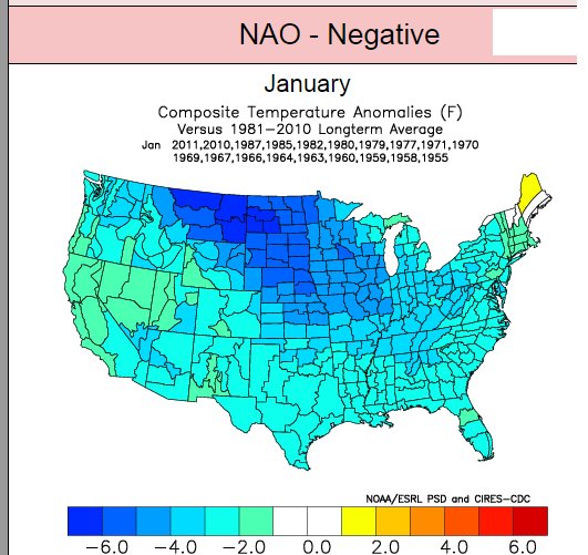
One possible reason for the surface temp anaomlies not matching up, this current Pacific jet extension appears to be shifted poleward. As it starts the process of relaxing, the lower heights start to retrograde towards the Aleutian Islands with amplification of heights across the Hudson Bay. All the while, Pacific air has been flooding N. American and downsloping off the Rockies into Canada. There just isn't any cold air to "block" for a storm. Will that change? We've seen some big -EPO dumps of cold so far this winter but -ENSO -EPO dumps typically are associated with big positive tilted troughs, nothing like the snow composite above. We were able to squeak out some snow out of the last system but that was a perfect timing setup with forcing and moisture briefly overlapping allowing for some snow (On a side note, a southerly shifted Pacific jet extension has been shown favor a pattern that allows cross polar flow when it relaxes).

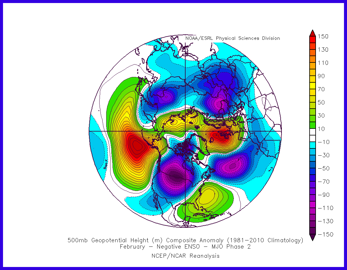
We probably need a shakeup in the low frequency background state before we see some cold in the southern plains that isn't driven by big -EPO. The MJO could certainly kick that process off but that probably won't happen until March, which is too late for most of Texas. There is pretty good consensus emerging that the MJO will pulse into Phase 1 but is that a true MJO and will it propagate? If it were to get into Phase 2 in early February, then that could be a very cold look.

Image

Only problem, that looks more "McFarlandish" than it does big Texas snow. Who knows what will actually happen but February should at least be interesting. Oh, and don't forget any possible SSW.
1 likes   
Winter time post are almost exclusively focused on the DFW area.

Golf7070
Tropical Storm
Tropical Storm
Posts: 115
Joined: Sun Oct 30, 2016 8:58 pm

Re: Texas Winter 2016-2017

#3708 Postby Golf7070 » Fri Jan 13, 2017 11:13 pm

Bubba, my gut tells me things fixing to get real interesting but I could be wrong. I believe changes are starting to take place in pacific that should allow the ball to be rolling, if you will. Also, like you mentioned, the possible SSW or some type of it. I'm not -removed- but from what I've read so far, it looks OK so far.
0 likes   

User avatar
JDawg512
Category 5
Category 5
Posts: 1077
Age: 45
Joined: Mon Aug 26, 2013 8:56 pm
Location: Austin
Contact:

Re: Texas Winter 2016-2017

#3709 Postby JDawg512 » Fri Jan 13, 2017 11:20 pm

Okay must be on the move again cause the temp has dropped to 59.
0 likes   
Resident Rain Miser

I am a weather hobbyist living 3.5 miles south of Downtown Austin and in no way or fashion should anything I say concerning forecasts be taken seriously. Please check your local NWS for accurate weather forecasting and conditions.

User avatar
bubba hotep
S2K Supporter
S2K Supporter
Posts: 5837
Joined: Wed Dec 28, 2016 1:00 am
Location: Collin County Texas

Re: Texas Winter 2016-2017

#3710 Postby bubba hotep » Fri Jan 13, 2017 11:24 pm

Golf7070 wrote:
Bubba, my gut tells me things fixing to get real interesting but I could be wrong. I believe changes are starting to take place in pacific that should allow the ball to be rolling, if you will. Also, like you mentioned, the possible SSW or some type of it. I'm not -removed- but from what I've read so far, it looks OK so far.


We are going on two years of the Pacific not really doing us any favors here in N. Texas, winter weather wise. That has started to change but I'm not convinced that those changes are rapidly occurring. The models are notorious for rushing pattern changes and we could just see a repeat of the current pattern with a PJR, big -EPO dump, PJE, +EPO and big warm up. That would be major bummer b/c that cycle would end up wasting most of February.
0 likes   
Winter time post are almost exclusively focused on the DFW area.

User avatar
bubba hotep
S2K Supporter
S2K Supporter
Posts: 5837
Joined: Wed Dec 28, 2016 1:00 am
Location: Collin County Texas

Re: Texas Winter 2016-2017

#3711 Postby bubba hotep » Fri Jan 13, 2017 11:31 pm

Hide your eyes!

Image
0 likes   
Winter time post are almost exclusively focused on the DFW area.

User avatar
Ntxw
Storm2k Moderator
Storm2k Moderator
Posts: 22787
Joined: Wed Oct 21, 2009 6:34 pm
Location: DFW, Texas

Re: Texas Winter 2016-2017

#3712 Postby Ntxw » Fri Jan 13, 2017 11:37 pm

I agree it could change to a Pacific EPO dominate look. The NAO has really failed to materialize with any significant duration. Especially the Euro which has been too -NAO happy. But to mention again SOI is giving me some optimism in that department, it won't be a fleeting negative reading should be some sustained duration of -SOI. Give me Feb climo, 33F and heavy qpf with cold air aloft :D. I feel the cold will be there somehow, getting cold hasn't been the issue this season, really it's more timing of shortwaves but anecdotal at best.
0 likes   
The above post and any post by Ntxw is NOT an official forecast and should not be used as such. It is just the opinion of the poster and may or may not be backed by sound meteorological data. It is NOT endorsed by any professional institution including Storm2k. For official information, please refer to NWS products.


  Help support Storm2K!

Help Support Storm2K


Golf7070
Tropical Storm
Tropical Storm
Posts: 115
Joined: Sun Oct 30, 2016 8:58 pm

Re: Texas Winter 2016-2017

#3713 Postby Golf7070 » Fri Jan 13, 2017 11:41 pm

Bubba, do you think we will want to see the models start to show interesting things if the mjo is actually going to the colder phases for real? I personally don't want another transient cold shot but that's not my decision. It makes it very difficult to see snow/ice chances here with transient type regime
0 likes   

User avatar
bubba hotep
S2K Supporter
S2K Supporter
Posts: 5837
Joined: Wed Dec 28, 2016 1:00 am
Location: Collin County Texas

Re: Texas Winter 2016-2017

#3714 Postby bubba hotep » Fri Jan 13, 2017 11:44 pm

Ntxw wrote:I agree it could change to a Pacific EPO dominate look. The NAO has really failed to materialize to of any significant duration. Especially the Euro which has been too -NAO happy. But to mention again SOI is giving me some optimism in that department, it won't be a fleeting negative reading should be some sustained duration of -SOI. Give me Feb climo, 33F and heavy qpf with cold air aloft :D. I feel the cold will be there somehow, getting cold hasn't been the issue this season, really it's more timing of shortwaves but anecdotal at best.


Yea, late Jan or Feb climo with a proper H5 pass can bring a dump to N. Texas. We don't need bitter cold to get a legit snow storm but we need at least climo. I'm not a huge fan of the SOI, it can't be played in the short range by transient features. Climo suggest that any MJO driven Pacific transition from -ENSO probably won't happen until March or April. The atmospheric ENSO footprint can lag the SST, they aren't always nicely coupled.
0 likes   
Winter time post are almost exclusively focused on the DFW area.

User avatar
Ntxw
Storm2k Moderator
Storm2k Moderator
Posts: 22787
Joined: Wed Oct 21, 2009 6:34 pm
Location: DFW, Texas

Re: Texas Winter 2016-2017

#3715 Postby Ntxw » Fri Jan 13, 2017 11:49 pm

bubba hotep wrote:Yea, late Jan or Feb climo with a proper H5 pass can bring a dump to N. Texas. We don't need bitter cold to get a legit snow storm but we need at least climo. I'm not a huge fan of the SOI, it can't be played in the short range by transient features. Climo suggest that any MJO driven Pacific transition from -ENSO probably won't happen until March or April. The atmospheric ENSO footprint can lag the SST, they aren't always nicely coupled.


The SOI can be a noisy signal. Especially when you see a tropical system in the vicinity of either Tahiti or Darwin but this seems to be because of larger scale pressure changes which is more legit driver of large scale convection. It's probably why the +PNA signal has been showing up for a little bit now. We need to get the convection out of Indonesia.
0 likes   
The above post and any post by Ntxw is NOT an official forecast and should not be used as such. It is just the opinion of the poster and may or may not be backed by sound meteorological data. It is NOT endorsed by any professional institution including Storm2k. For official information, please refer to NWS products.


  Help support Storm2K!

Help Support Storm2K


User avatar
Ntxw
Storm2k Moderator
Storm2k Moderator
Posts: 22787
Joined: Wed Oct 21, 2009 6:34 pm
Location: DFW, Texas

Re: Texas Winter 2016-2017

#3716 Postby Ntxw » Fri Jan 13, 2017 11:57 pm

Before any of that though, it's going to be warm the next week to week and a half. 60s and 70s for highs, 40s and 50s for lows which in January is well above normal. Heat Miser cranking up the thermostat again. Anything interesting aside from the rain next few days will wait until after next weekend.
0 likes   
The above post and any post by Ntxw is NOT an official forecast and should not be used as such. It is just the opinion of the poster and may or may not be backed by sound meteorological data. It is NOT endorsed by any professional institution including Storm2k. For official information, please refer to NWS products.


  Help support Storm2K!

Help Support Storm2K


User avatar
TeamPlayersBlue
Category 5
Category 5
Posts: 3445
Joined: Tue Feb 02, 2010 1:44 am
Location: Denver/Applewood, CO

Re: Texas Winter 2016-2017

#3717 Postby TeamPlayersBlue » Sat Jan 14, 2017 3:50 am

northjaxpro wrote:
TeamPlayersBlue wrote:Wow, im surprised you get that many freezes there. We have had 3 so far in SW Houston.


Well, I am in the Jacksonville /Northern Jax area in Northeast Florida. Yes, we get our fair share of freezes here, but my.point in the previous post is that the average number of freezes has reduced considerably over the past six years . The Big Bend region and the Panhandle areas typically get a few more freezes than here in Northeast Florida because of the moderating influence at times when the surface winds become onshore from the Atlantic.


We havent had much -NAO instances in the last 7 years, I think this has alot to do with it.
0 likes   
Personal Forecast Disclaimer:
The posts in this forum are NOT official forecast and should not be used as such. They are just the opinion of the poster and may or may not be backed by sound meteorological data. They are NOT endorsed by any professional institution or storm2k.org. For official information, please refer to the NHC and NWS products.

User avatar
northjaxpro
S2K Supporter
S2K Supporter
Posts: 8900
Joined: Mon Sep 27, 2010 11:21 am
Location: Jacksonville, FL

Re: Texas Winter 2016-2017

#3718 Postby northjaxpro » Sat Jan 14, 2017 8:49 am

TeamPlayersBlue wrote:
northjaxpro wrote:
TeamPlayersBlue wrote:Wow, im surprised you get that many freezes there. We have had 3 so far in SW Houston.


Well, I am in the Jacksonville /Northern Jax area in Northeast Florida. Yes, we get our fair share of freezes here, but my.point in the previous post is that the average number of freezes has reduced considerably over the past six years . The Big Bend region and the Panhandle areas typically get a few more freezes than here in Northeast Florida because of the moderating influence at times when the surface winds become onshore from the Atlantic.


We havent had much -NAO instances in the last 7 years, I think this has alot to do with it.


I mentioned the positive NAO and its influence on a previous post in this thread. I think it is on the previous page from this one.
1 likes   
NEVER, EVER SAY NEVER in the tropics and weather in general, and most importantly, with life itself!!

________________________________________________________________________________________

Fay 2008 Beryl 2012 Debby 2012 Colin 2016 Hermine 2016 Julia 2016 Matthew 2016 Irma 2017 Dorian 2019

User avatar
TexasF6
S2K Supporter
S2K Supporter
Posts: 816
Joined: Mon Aug 09, 2004 9:33 pm
Location: Austin, TX

Re: Texas Winter 2016-2017

#3719 Postby TexasF6 » Sat Jan 14, 2017 9:22 am

Well, sneaky cold air has it chilly at the LonghornWxCenter, 49* wasn't forecasted yesterday! #SneakyColdAir
0 likes   

User avatar
Ntxw
Storm2k Moderator
Storm2k Moderator
Posts: 22787
Joined: Wed Oct 21, 2009 6:34 pm
Location: DFW, Texas

Re: Texas Winter 2016-2017

#3720 Postby Ntxw » Sat Jan 14, 2017 10:36 am

So 12z GFS yesterday had the cold front come through, says we should be at or just above 50 degrees by 9am this morning. It's 40 and drizzling at DFW. The run had DFW warming up to 65 by this afternoon that run. Today's runs are a little better but still wasn't cold enough. #outtolunch

Image

Image

The core of the arctic high has already moved on east, but the wedge of low level cold has hung on in the southern plains. Been textbook case of coarse guidance not delivering cold and eroding it too fast.
0 likes   
The above post and any post by Ntxw is NOT an official forecast and should not be used as such. It is just the opinion of the poster and may or may not be backed by sound meteorological data. It is NOT endorsed by any professional institution including Storm2k. For official information, please refer to NWS products.


  Help support Storm2K!

Help Support Storm2K


Return to “Winter Weather”

Who is online

Users browsing this forum: No registered users and 12 guests