NWS FTW TX
THE ATMOSPHERE WILL TEMPORARILY DRY OUT OVER NORTH TEXAS THURSDAY
THOUGH FRIDAY BEFORE THE NEXT UPPER SYSTEM ARRIVES IN SOUTHWEST
TEXAS SOMETIME ON SATURDAY. THE ECMWF AND GFS MODELS ARE STILL NOT
IN COMPLETE AGREEMENT ON THE TRACK OF THE UPPER LOW OR HOW COLD IT
WILL BE...BUT BOTH AGREE THAT PRECIPITATION WILL BE POSSIBLE
ACROSS NORTH TEXAS OVER THE HOLIDAY WEEKEND. AT THIS POINT IN TIME WE
ARE INCLINED TO BELIEVE THE WARMER ECM SOLUTION...SO WE WILL KEEP
A CHANCE OF RAIN AND THUNDERSTORMS IN THE FORECAST FOR SATURDAY
AND SUNDAY. WE WILL BE WATCHING THIS SYSTEM CLOSELY IN THE COMING
DAYS.
Texas Winter Weather Thread #3 - GFS showing cold christmas
Moderator: S2k Moderators
Forum rules
 The posts in this forum are NOT official forecast and should not be used as such. They are just the opinion of the poster and may or may not be backed by sound meteorological data. They are NOT endorsed by any professional institution or STORM2K.

The posts in this forum are NOT official forecast and should not be used as such. They are just the opinion of the poster and may or may not be backed by sound meteorological data. They are NOT endorsed by any professional institution or STORM2K.
-
CaptinCrunch

- S2K Supporter

- Posts: 8776
- Age: 57
- Joined: Mon Nov 03, 2003 4:33 pm
- Location: Kennedale, TX (Tarrant Co.)
right now I will go with them on the forecast
0 likes
-
Lowpressure

- S2K Supporter
- Posts: 2032
- Age: 58
- Joined: Sun Sep 14, 2003 9:17 am
- Location: Charlotte, North Carolina
Looking from a non Texan perspective, I think this really bears watching, but more inland than some might want to admit. The potential is there, but the speed of the system might outrun the really cold air along the coast. It looks like NWS Austin has a good handle on this and may be the key to the evolution of the situation( from a forecast standpoint). Look at it this way, at least you have the chance for something, here in Charlotte it is getting ridiculous.
0 likes

Lowpressure wrote:Looking from a non Texan perspective, I think this really bears watching, but more inland than some might want to admit. The potential is there, but the speed of the system might outrun the really cold air along the coast. It looks like NWS Austin has a good handle on this and may be the key to the evolution of the situation( from a forecast standpoint). Look at it this way, at least you have the chance for something, here in Charlotte it is getting ridiculous.
I think it will be hard to have snow with temperatures in the 40's for highs in central and south Texas. As much as I want to have snow for Christmas, I don't see really cold air coming down. Highs in Amarillo for next weekend are in the upper 30's, which means that it will be at least 10 degrees warmer for us in central and southeast Texas. Also the EURO is warmer than the GFS and only shows a cold rain and no snow. At the very least it looks like it will be much cooler and feel like Christmas instead of Easter.
0 likes
-
jasons2k

- Storm2k Executive

- Posts: 8290
- Age: 52
- Joined: Wed Jul 06, 2005 12:32 pm
- Location: The Woodlands, TX
I sure was surprised to see RAIN this morning.
Anyway, my thoughts on the upcoming event are what's been echoed by so many - it's still way too early to pinpoint anything. Jeff is right, things will change.
I'll certainly be watching as we'll be in Dallas (Allen) for Christmas, but if I were staying in Houston I really don't think there'd be anything to get excited about - other than it being cool enough to burn a fire.
0 likes
I'd have to agree with jschlitz, I just don't see it getting cold enough for us here in Southeast, Texas to get snow out of this. What I see coming out of this is a cold rain/sleet with some snow flurries across the hill country and central Texas. For us here in Southeast, Texas it looks like a cold rain. As long as it is cold enough to get a fire going I'll be happy.
0 likes
-
cctxhurricanewatcher

- Category 5

- Posts: 1206
- Joined: Sun Sep 12, 2004 8:53 pm
- Location: Corpus Christi, Texas
Johnny wrote:I'd have to agree with jschlitz, I just don't see it getting cold enough for us here in Southeast, Texas to get snow out of this. What I see coming out of this is a cold rain/sleet with some snow flurries across the hill country and central Texas. For us here in Southeast, Texas it looks like a cold rain. As long as it is cold enough to get a fire going I'll be happy.
Same here. Cloudy, Cold and damp would do the trick.
0 likes
-
Portastorm

- Storm2k Moderator

- Posts: 9954
- Age: 63
- Joined: Fri Jul 11, 2003 9:16 am
- Location: Round Rock, TX
- Contact:
All enthusiasm aside ... meteorological reality demands caution here. These upper-low scenarios are dicey to forecast so far out. In fact, I think its prudent to wait until about 36-48 hrs before the actual event before sounding any alarms.
I wouldn't be surprised to get my usual "cloudy and cold" out of this while my buddy CC in Corpus gets 10 inches of snow!
That's how it usually happens ...
I wouldn't be surprised to get my usual "cloudy and cold" out of this while my buddy CC in Corpus gets 10 inches of snow!
That's how it usually happens ...
0 likes
-
aggiecutter
- Category 5
- Posts: 1755
- Joined: Thu Oct 14, 2004 9:22 pm
- Location: Texarkana
There is way too much smoke with this scenario for there not to be a fire. I would bet a lot of money that an area north of Austin to Lufkin is going to have a very significant winter storm this weekend. I have no doubt there will be enough cold air in place over the northern half of the state as Canada is currently reloading with arctic air. The key will be the track of the low. If it forms in the NW Gulf, there will be ample moisture available for a very significant event. It forms farther south and to the east, then the winter event will be much less significant. A definitive answer to this question won't be answered until, as portastorm pointed out, 36-48 hours before the event. I also agree with someone who mentioned above that this will be an inland event for the most part.
Current Canadian Temperatures:
http://twister.sbs.ohio-state.edu/surface/ustemp.gif
Current Canadian Temperatures:
http://twister.sbs.ohio-state.edu/surface/ustemp.gif
0 likes
-
Extremeweatherguy

- Category 5
- Posts: 11095
- Joined: Mon Oct 10, 2005 8:13 pm
- Location: Florida
keep in mind, those forecast highs are for 6-7 days out and the NWS is being cautious at this point. They (the forecasted temperatures) will drop further if the models look the same by the end of the week.double D wrote:Lowpressure wrote:Looking from a non Texan perspective, I think this really bears watching, but more inland than some might want to admit. The potential is there, but the speed of the system might outrun the really cold air along the coast. It looks like NWS Austin has a good handle on this and may be the key to the evolution of the situation( from a forecast standpoint). Look at it this way, at least you have the chance for something, here in Charlotte it is getting ridiculous.
I think it will be hard to have snow with temperatures in the 40's for highs in central and south Texas. As much as I want to have snow for Christmas, I don't see really cold air coming down. Highs in Amarillo for next weekend are in the upper 30's, which means that it will be at least 10 degrees warmer for us in central and southeast Texas. Also the EURO is warmer than the GFS and only shows a cold rain and no snow. At the very least it looks like it will be much cooler and feel like Christmas instead of Easter.
BTW: The 12z run of the GFS continues to show a very, very cold Christmas period with the first shot of cold air reaching us on the 23rd, then another (possibly stronger) shot reaching us on the 26th or so. This is now the 7th run in a row to advertise possible winter weather and cold. A consistant trend like this cannot be ignored.
0 likes
I undertand the trend EWG and it's very encouraging but another met pointed out 3 factors that will come into play. The first is that their is no snow pack off to the north of us. Secondly, we have had very warm weather thoughout the country for the past week so any cold air that does come in will be greatly modified and thirdly...we presently don't have any cold air over us right now. The third one doesn't mean much but I think they other two will be what keeps us from getting any wintry precipitation out of this.
Any thoughts on this anyone?
Any thoughts on this anyone?
0 likes

-
Extremeweatherguy
- Category 5
- Posts: 11095
- Joined: Mon Oct 10, 2005 8:13 pm
- Location: Florida
Here is a detailed look at the 12z:
http://www.nco.ncep.noaa.gov/pmb/nwprod/analysis/namer/gfs/12/fp1_126.shtml
^^cold front pushing down state as low pressure spins up along S. Texas coast on the afternoon of the 23rd.^^
http://www.nco.ncep.noaa.gov/pmb/nwprod ... _132.shtml
^^By the evening of the 23rd, most of the state is below 50F and NW parts are below freezing. Upper level air will be cold enough for some ice/snow to begin falling in north and central TX.^^
http://www.nco.ncep.noaa.gov/pmb/nwprod ... _138.shtml
^^Temperature continue to fall and by about 12am on Christmas eve it is cold enough for winter weather in many places (as the 850mb temps. go below 0C and the 540 thickness line shoots south). However, by this point, most of the heavy precip. should be on it's way out.^^
http://www.nco.ncep.noaa.gov/pmb/nwprod ... _144.shtml
^^By sunrise Christmas eve, most places are cold enough for snow/ice but only light wrap-around precip. should remain.^^
http://www.nco.ncep.noaa.gov/pmb/nwprod ... _150.shtml
^^The high on Christmas eve should be below 50F.^^
http://www.nco.ncep.noaa.gov/pmb/nwprod ... _168.shtml
^^Temperatures fall to near or below freezing by Christmas morning north of I-10.^^
http://www.nco.ncep.noaa.gov/pmb/nwprod ... _174.shtml
^^Highs on Christmas should also be below 50F with VERY cold upper-level temperatures (perfect for snow). However, at this point, most of the precip. should be gone.^^
http://www.nco.ncep.noaa.gov/pmb/nwprod ... _180.shtml
^^Some flurries may re-develop over parts of the state by Christmas eve.^^
http://www.nco.ncep.noaa.gov/pmb/nwprod ... _192.shtml
^^Another freeze likely the day after Christmas with some winter weather off to our east.^^
At this point, it looks like cold air is a good bet. The thing I will be watching closely is the speed and location of the low. If it is slower, then we could be looking at a MAJOR winter storm all the way to the coast...if it is faster, then we may be seeing possibly a brief mix-over, but nothing extreme...mostly cold rain for east TX. We will have to watch closely!
0 likes
-
Extremeweatherguy
- Category 5
- Posts: 11095
- Joined: Mon Oct 10, 2005 8:13 pm
- Location: Florida
-
jasons2k
- Storm2k Executive
- Posts: 8290
- Age: 52
- Joined: Wed Jul 06, 2005 12:32 pm
- Location: The Woodlands, TX
Hey Johnny,
You're right and Jeff alluded to some of that in his most recent email. Temps just above the surface may get below 0C but it will be hard to get to freezing right at the surface before the precip leaves without some dynamic cooling or raging mad CAA in place.
One thing that JB likes to harp on is source regions and I think that will come into play with this system. The air's source region isn't the type of setup where we see S. Texas snowstorms. It looks like the ULL will have enough dymamic cooling in place for some scattered winter precip with a fairly narrow band of decent accumulations...but it doesn't look like it will be cold enough, or track far south enough for anything frozen in the Houston area. Just my $.02 - and that's all it's worth this far away.
0 likes
-
southerngale

- Retired Staff

- Posts: 27418
- Joined: Thu Oct 10, 2002 1:27 am
- Location: Southeast Texas (Beaumont area)
Highs in the 40's? Wasn't it showing highs in the 30's the other day?
jschlitz...I care. lol
I checked Accuweather's 15-day forecast last night, just to see. That was the first time I'd checked it since last year, I believe. I think I was looking for that snow icon then too. hehe
At least I won't be running my A/C on Christmas!!
jschlitz...I care. lol
I checked Accuweather's 15-day forecast last night, just to see. That was the first time I'd checked it since last year, I believe. I think I was looking for that snow icon then too. hehe
At least I won't be running my A/C on Christmas!!
0 likes
-
jasons2k
- Storm2k Executive
- Posts: 8290
- Age: 52
- Joined: Wed Jul 06, 2005 12:32 pm
- Location: The Woodlands, TX
Extremeweatherguy wrote:Don't forget though that those forecasts are computer generated.jschlitz wrote:Thought for the day:
I find it a bit humorous that when neither TWC nor AccuWx show any kind of snow/ice in the forecast NOBODY seems to care or mention it.
EXACTLY. And that just goes to my point.
When they don't show anything - funny how the silence is defeaning, but when the first flake pops on a graphic, it'll get posted 10X from every source.
0 likes
-
Extremeweatherguy
- Category 5
- Posts: 11095
- Joined: Mon Oct 10, 2005 8:13 pm
- Location: Florida
This cold air is actually going to be coming from the currently cold and snowy NW though. That area has not been very warm lately, so I think it may have less of an influence than if it was going to come from straight north of here. However, this airmass will also not be truly arctic, so extremely cold air is not likely. With that said though, evaporative cooling may (hopefully) do just enough to bring us a burst of winter weather before all is said and done.Johnny wrote:I undertand the trend EWG and it's very encouraging but another met pointed out 3 factors that will come into play. The first is that their is no snow pack off to the north of us. Secondly, we have had very warm weather thoughout the country for the past week so any cold air that does come in will be greatly modified and thirdly...we presently don't have any cold air over us right now. The third one doesn't mean much but I think they other two will be what keeps us from getting any wintry precipitation out of this.
Any thoughts on this anyone?
At this point I am just hoping that the model trends continue and that everything plays out perfectly.
BTW, here is the current U.S. high temperature departure from normal map so you can see what I am talking about. The area this airmass will be moving across is actually a bit colder than normal right now:
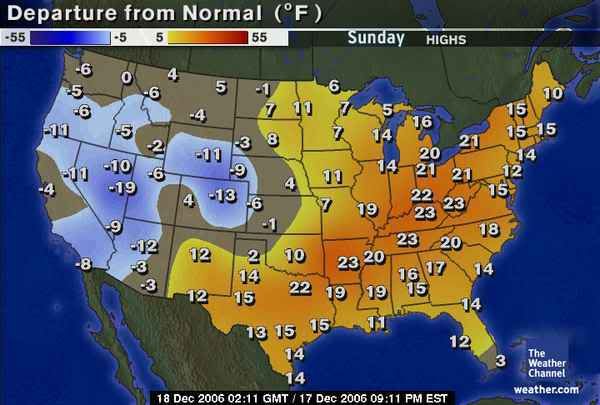
Also don't forget the snow/ice expected for the panhandle the next few days.
Last edited by Extremeweatherguy on Mon Dec 18, 2006 2:16 pm, edited 2 times in total.
0 likes
-
Extremeweatherguy
- Category 5
- Posts: 11095
- Joined: Mon Oct 10, 2005 8:13 pm
- Location: Florida
The possible 30s was based on the fact that it also showed precip. falling that day. Now, the latest run brings in the precip. much sooner and exits it much sooner which may allow for a little Christmas day clearing..thus warmer high temperatures.southerngale wrote:Highs in the 40's? Wasn't it showing highs in the 30's the other day?
jschlitz...I care. lol
I checked Accuweather's 15-day forecast last night, just to see. That was the first time I'd checked it since last year, I believe. I think I was looking for that snow icon then too. hehe
At least I won't be running my A/C on Christmas!!
It all really depends on cloud cover, precip. and the exact amount of cold air in place. We should know more about the exact forecast in a few days.
0 likes
-
Brent
- S2K Supporter
- Posts: 38714
- Age: 37
- Joined: Sun May 16, 2004 10:30 pm
- Location: Tulsa Oklahoma
- Contact:
WOW. This is a big change.
SPC 4-8 day outlook:
...DISCUSSION...
PROGRESSIVE UPPER AIR PATTERN FCST THROUGH PERIOD AS SERIES OF
HIGH-AMPLITUDE WAVES MOVES ACROSS CONUS. UPPER LOW NOW DEVELOPING
OVER SRN CA WILL EJECT NEWD ACROSS CENTRAL PLAINS DAY-3 THEN WEAKEN
OVER GREAT LAKES AND ST LAWRENCE VALLEY DAYS 4-5/THU-FRI.
MRGL/CONDITIONAL SVR POTENTIAL MAY ACCOMPANY OR PRECEDE ASSOCIATED
COLD FRONT THU OVER GULF COAST. LARGE SEPARATION LIKELY BETWEEN
MOST FAVORABLE LOW LEVEL AIR MASS AND STRONGEST DEEP-LAYER FORCING
PRECLUDES CATEGORICAL OUTLOOK. THEREAFTER...MOST PROGS INDICATE
DEEP TROUGH DIGGING SEWD OVER GREAT BASIN THEN PIVOTING EWD ACROSS
TX OR EXTREME NRN MEX...WITH CONSIDERABLE VARIATION IN EVOLUTION
THEREAFTER. GIVEN MORE NRN TRACK OF SPECTRAL AND SOME MREF ENSEMBLE
MEMBERS...COMPARED TO LOW-LATITUDE ECMWF/UKMET PROGS...SOME SVR
POTENTIAL MAY MOVE INLAND SERN CONUS DURING DAYS 6-8/SAT-MON.
HOWEVER CONFIDENCE IS TOO LOW ATTM FOR SVR OUTLOOK.
Heh.
Last edited by Brent on Mon Dec 18, 2006 1:15 pm, edited 1 time in total.
0 likes
#neversummer
Who is online
Users browsing this forum: AnnularCane, bohaiboy, Quixotic, sandral, SnowyOwl31 and 71 guests