2007/2008 Snow coverage graphics
Moderator: S2k Moderators
Forum rules
 The posts in this forum are NOT official forecast and should not be used as such. They are just the opinion of the poster and may or may not be backed by sound meteorological data. They are NOT endorsed by any professional institution or STORM2K.

The posts in this forum are NOT official forecast and should not be used as such. They are just the opinion of the poster and may or may not be backed by sound meteorological data. They are NOT endorsed by any professional institution or STORM2K.


Re: 2006/2007 Snow coverage graphics
It looks like the Marine Summer Solstice (September 10) has come. After today, the hurricane season will wane, the bath water in the Gulf of Mexico and off the Atlantic will begin to cool, and the sea ice in the Arctic will begin to increase. I have already seen some snow start to form in northeastern Russia, and parts of the Arctic sea ice may be increasing. But two days ago there was a dramatic decrease, with a lot of iceberging. Today there was a modest increase near the Russian shore. So now the question is, when will the ice sheet start to increase, and how far will it melt before it does so?
0 likes
-
gboudx

- S2K Supporter

- Posts: 4090
- Joined: Thu Sep 04, 2003 1:39 pm
- Location: Rockwall, Tx but from Harvey, La
Re:
bob rulz wrote:Yes, I have noticed. It is projected that we will see a new all-time ice coverage low come September.
Here's an article about that:
http://www.cnn.com/2007/TECH/science/09 ... index.html
Arctic sea ice cover at record low
BOULDER, Colorado (CNN) -- Ice cover in the Arctic Ocean, long held to be an early warning of a changing climate, has shattered the all-time low record this summer, according to scientists from the National Snow and Ice Data Center in Boulder.
Using satellite data and imagery, NSIDC now estimates the Arctic ice pack covers 4.24 million square kilometers (1.63 million square miles) -- equal to just less than half the size of the United States. This figure is about 20 percent less than the previous all-time low record of 5.32 million square kilometers (2.05 million square miles) set in September 2005
Mark Serreze, senior research scientist at NSIDC, termed the decline "astounding."
"It's almost an exclamation point on the pronounced ice loss we've seen in the past 30 years," he said.
Most researchers had anticipated that the complete disappearance of the Arctic ice pack during summer months would happen after the year 2070, he said, but now, "losing summer sea ice cover by 2030 is not unreasonable."
0 likes
Re: 2006/2007 Snow coverage graphics: Less Ice but More Snow
An interesting sidelight on this melting of Arctic sea ice is that the sea ice is STILL melting - yesterday I saw a reduction - but now the snow in the Arctic lands is INCREASING. Further, comparison with last year at this time shows that this year has less sea ice but also more snow. The entire tip of Quebec is covered with snow this year, but not last year. Perhaps the warm Arctic waters are colliding with cold air masses forming in the interior of the land to form the snow.
0 likes
-
CaptinCrunch

- S2K Supporter
- Posts: 8776
- Age: 58
- Joined: Mon Nov 03, 2003 4:33 pm
- Location: Kennedale, TX (Tarrant Co.)
Re: 2006/2007 Snow coverage graphics
You are correct, with the increased tempretures of the arctic ocean you get a sort of ocean effect snow, much like the lake effect snows around the great lakes. So seeing more snow cover is the result of the warmer arctic waters.
0 likes
-
CaptinCrunch
- S2K Supporter
- Posts: 8776
- Age: 58
- Joined: Mon Nov 03, 2003 4:33 pm
- Location: Kennedale, TX (Tarrant Co.)
Re: 2006/2007 Snow coverage graphics
Here's 2 good link's to see and keep track of the polor ice cap as it compares to last year on the same date.
http://arctic.atmos.uiuc.edu/CT/animate.arctic.0.html
http://polar.ncep.noaa.gov/seaice/nh.html


Left pic: Oct 3, 2007................................Right pic: Oct 3, 2006
http://arctic.atmos.uiuc.edu/CT/animate.arctic.0.html
http://polar.ncep.noaa.gov/seaice/nh.html
Left pic: Oct 3, 2007................................Right pic: Oct 3, 2006
0 likes
-
Extremeweatherguy

- Category 5

- Posts: 11095
- Joined: Mon Oct 10, 2005 8:13 pm
- Location: Florida

^^Current date^^

^^Dec. 19th, 2006^^
Last edited by Extremeweatherguy on Wed Dec 19, 2007 12:53 am, edited 28 times in total.
0 likes
Re: 2006/2007 Snow coverage graphics
This is what I have been noticing. I think the increased snowcover may be partially due to the icefree warm Arctic evaporating its water into the atmosphere which later comes down as snow. What will this mean for the weather? I suspect that highs to form in central Siberia and northeastern part of Hudson Bay towards Baffin Island and a low in the icefree Arctic Ocean. I don't know what it means for our winter weather, except that it may be warmer than usual, with more snow.
0 likes
-
Extremeweatherguy
- Category 5
- Posts: 11095
- Joined: Mon Oct 10, 2005 8:13 pm
- Location: Florida
Ice pack starting to build in along the NW coast of Canada and the northern coast of Alaska. If you compare to the map from 2006, you can see that that same area had little to no ice at the same point last year. There is also a lot more snow this year too (compared to 2006) in the NW Canada and Alaska region. Considering that region is usually the source for most of our cold spells in TX, I am definitely watching closely to see if the potential will be there for a strong arctic blast sometime this winter. It certainly looks like the stage is being set...
0 likes
Re: 2006/2007 Snow coverage graphics
The stage is also set for abnormally warm weather in the US as well. You folks in Texas may have 96 degrees on January 15, followed by 48 inches on the 16th.
0 likes
Re: 2006/2007 Snow coverage graphics
I know that the alternating sun and clouds can play tricks on you, but was that ice I saw on the horizon from the Barrow webcam at http://www.gi.alaska.edu/snowice/sea-la ... ebcam.html ? In the latest image you can't see it because of darkness and haze, but earlier I saw a white line on the horizon to the left.
I note now that ice is beginning to form at several places along the coasts of both Siberia and the North American continent. In addition, someone in Ontario must have had a snowstorm.
I note now that ice is beginning to form at several places along the coasts of both Siberia and the North American continent. In addition, someone in Ontario must have had a snowstorm.
0 likes
Re: 2006/2007 Snow coverage graphics
Yes it should. How do you do that? Maybe it should be 2006-2008.
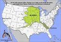
It seems that the Arctic sea ice is about the same as it was on 2006 November 20, a year ago. It has rapidly moved from losing nearly half its area near Siberia in September to about normal now. In fact, Hudson Bay is starting to ice over, and it did not do that last year until November 24. The snow cover seems the same or more than last year, and I note that the first incursion of widespread snow into the western US has occurred.
However, we are getting some really warm temperatures in the Arctic. According to Wunderground, Barrow, AK, should have a high of 3 and a low of -9 (F) at this time of the year. Instead it is 10 degrees there, and it is supposed to warm up to 15 tonight and remain around 15 for some days, and no below-zero weather is expected in this period. Alert, way up on the tip of Ellesmere Island, has an average high of -11 and an average low of -24 right now. Instead, it is 6 degrees (above zero) there, and it is supposed to warm up to 12 and stay there for some time.
This suggests that we may get Arctic cold outbreaks, but they will not be severe, and as a result, warm air from the South may prevail, giving us a warmer (but rainier, or maybe snowier) winter than normal.
0 likes
-
Extremeweatherguy
- Category 5
- Posts: 11095
- Joined: Mon Oct 10, 2005 8:13 pm
- Location: Florida
Re: 2006/2007 Snow coverage graphics
The reason they are warm right now is because of a building ridge. As this ridge builds north, it will help push a trough into the United States, and this is very common to see. Usually, when we are cooler than normal down here, they are warmer than normal up there due to this ridge/trough relationship. That is why it is probably not wise to use short term temperature trends in predicting patterns for the winter as a whole. There is a decent chance, in fact, that with it being a La Nina year, Alaska will return to a near normal or even slightly below normal temperature regime by late December and into January while the eastern and central United States begin to warm up some. As the cold air builds back to our north though, all it will take is a small slip in the jet to bring the cold crashing into the country during the winter. These events will be few and far between (thus the reason that overall this winter should be mild), but personally I feel they will actually be more severe than usual when they do occur (since the source region should be seeing near or below normal temperatures during the heart of the winter). Definitely seems interesting, IMO. We shall see what happens..jimvb wrote:Yes it should. How do you do that? Maybe it should be 2006-2008.
It seems that the Arctic sea ice is about the same as it was on 2006 November 20, a year ago. It has rapidly moved from losing nearly half its area near Siberia in September to about normal now. In fact, Hudson Bay is starting to ice over, and it did not do that last year until November 24. The snow cover seems the same or more than last year, and I note that the first incursion of widespread snow into the western US has occurred.
However, we are getting some really warm temperatures in the Arctic. According to Wunderground, Barrow, AK, should have a high of 3 and a low of -9 (F) at this time of the year. Instead it is 10 degrees there, and it is supposed to warm up to 15 tonight and remain around 15 for some days, and no below-zero weather is expected in this period. Alert, way up on the tip of Ellesmere Island, has an average high of -11 and an average low of -24 right now. Instead, it is 6 degrees (above zero) there, and it is supposed to warm up to 12 and stay there for some time.
This suggests that we may get Arctic cold outbreaks, but they will not be severe, and as a result, warm air from the South may prevail, giving us a warmer (but rainier, or maybe snowier) winter than normal.
BTW, You can see the current building ridge at these links:
24 hrs. from now - http://www.nco.ncep.noaa.gov/pmb/nwprod ... 0_024l.gif
48 hrs. from now - http://www.nco.ncep.noaa.gov/pmb/nwprod ... 0_048l.gif
0 likes
-
CajunMama
- Retired Staff

- Posts: 10791
- Joined: Thu Feb 06, 2003 9:57 pm
- Location: 30.22N, 92.05W Lafayette, LA
Re: 2007/2008 Snow coverage graphics
f5 wrote:what took so long to update this post
Which members post are you talking about?
0 likes
-
Aquawind

- Category 5
- Posts: 6714
- Age: 62
- Joined: Mon Jun 16, 2003 10:41 pm
- Location: Salisbury, NC
- Contact:
Re: 2007/2008 Snow coverage graphics
I thought a new thread would have been started for the new snow season but it doesn't matter. Looks like we will have some widespread depth added this weekend.
Here is November 30th 2007.

Here is November 30th 2007.
0 likes

-
Extremeweatherguy
- Category 5
- Posts: 11095
- Joined: Mon Oct 10, 2005 8:13 pm
- Location: Florida

-
MCorder
- Professional-Met

- Posts: 42
- Joined: Wed Aug 02, 2006 4:58 pm
- Location: Kodiak Alaska
- Contact:
Re: 2007/2008 Snow coverage graphics
Figured I'd chime in on this...
Alaska Snow Coverage...

Alaska Sea Ice Coverage...

My favorite Arctic ice coverage map...

Thanks
MCorder
Kodiak Alaska
KodiakWX.com
Alaska Snow Coverage...
Alaska Sea Ice Coverage...
My favorite Arctic ice coverage map...
Thanks
MCorder
Kodiak Alaska
KodiakWX.com
0 likes
Who is online
Users browsing this forum: No registered users and 124 guests