Southern Plains winter wx thread (2009-2010)

Winter Weather Discussion

Moderator: S2k Moderators

Forum rules

The posts in this forum are NOT official forecast and should not be used as such. They are just the opinion of the poster and may or may not be backed by sound meteorological data. They are NOT endorsed by any professional institution or STORM2K.

Help Support Storm2K
Message
Author
Peanut432
Tropical Storm
Tropical Storm
Posts: 119
Joined: Mon Jan 25, 2010 10:21 pm
Location: Hollis Ok

Re: Southern Plains winter wx thread (2009-2010)

#401 Postby Peanut432 » Wed Jan 27, 2010 12:01 am

Extremeweatherguy wrote:The Cobb Output based on the 00z NAM shows the following accumulations for Oklahoma City and Norman...

OKLAHOMA CITY
Snow = 2.6"+
Sleet = 1.07"
Frz Rain = 1.58" :eek:

NORMAN
Snow = 1.4"+
Sleet = 1.13"
Frz Rain = 1.83" :eek:

We better hope and pray that the NAM is wrong! Over 1.5" of freezing rain would be absolutely devastating if it verified! I really, really hope that we switch over to snow/sleet more quickly than the NAM is showing and avoid this disaster!

I will post the 00z GFS Cobb output once it becomes available. As of right now I predict, based on what i'm seeing, that the GFS output will include more in the way of snow/sleet accumulations and less in the way of ice (which is VERY GOOD).

(BTW: This is where I am obtaining the above information -> http://www.meteor.iastate.edu/~ckarsten ... index.html )


When does the GFS come out exactly? Which is more accurate for this time frame
0 likes   

User avatar
srainhoutx
S2K Supporter
S2K Supporter
Posts: 6919
Age: 67
Joined: Sun Jan 14, 2007 11:34 am
Location: Haywood County, NC
Contact:

Re: Southern Plains winter wx thread (2009-2010)

#402 Postby srainhoutx » Wed Jan 27, 2010 12:04 am

Junia wrote:Could someone give me an educated guess at this point for Memphis, TN? Thanks!


Going to be real close on p-type issues for Memphis. You are in an area outlined by the HPC so pay close attention to the NWS tomorrow.
0 likes   
Carla/Alicia/Jerry(In The Eye)/Michelle/Charley/Ivan/Dennis/Katrina/Rita/Wilma/Ike/Harvey

Member: National Weather Association
Wx Infinity Forums
http://wxinfinity.com/index.php

Facebook.com/WeatherInfinity
Twitter @WeatherInfinity

User avatar
Extremeweatherguy
Category 5
Category 5
Posts: 11095
Joined: Mon Oct 10, 2005 8:13 pm
Location: Florida

Re: Southern Plains winter wx thread (2009-2010)

#403 Postby Extremeweatherguy » Wed Jan 27, 2010 12:06 am

Peanut432 wrote:
Extremeweatherguy wrote:The Cobb Output based on the 00z NAM shows the following accumulations for Oklahoma City and Norman...

OKLAHOMA CITY
Snow = 2.6"+
Sleet = 1.07"
Frz Rain = 1.58" :eek:

NORMAN
Snow = 1.4"+
Sleet = 1.13"
Frz Rain = 1.83" :eek:

We better hope and pray that the NAM is wrong! Over 1.5" of freezing rain would be absolutely devastating if it verified! I really, really hope that we switch over to snow/sleet more quickly than the NAM is showing and avoid this disaster!

I will post the 00z GFS Cobb output once it becomes available. As of right now I predict, based on what i'm seeing, that the GFS output will include more in the way of snow/sleet accumulations and less in the way of ice (which is VERY GOOD).

(BTW: This is where I am obtaining the above information -> http://www.meteor.iastate.edu/~ckarsten ... index.html )


When does the GFS come out exactly? Which is more accurate for this time frame
The GFS has already run, but the COBB precipitation amount data has not been generated yet. It will be probably arrive sometime soon though. As for accuracy, I am not really sure which of the two models does better in a storm situation like this one. I am sure they both have their strengths and weaknesses in a setup such as this. May be somebody else could answer that for you.
0 likes   

Junia
Tropical Wave
Tropical Wave
Posts: 8
Joined: Tue Jan 26, 2010 11:49 pm
Location: Memphis, TN

Re: Southern Plains winter wx thread (2009-2010)

#404 Postby Junia » Wed Jan 27, 2010 12:13 am

srainhoutx wrote:
Junia wrote:Could someone give me an educated guess at this point for Memphis, TN? Thanks!


Going to be real close on p-type issues for Memphis. You are in an area outlined by the HPC so pay close attention to the NWS tomorrow.


Thanks, srainhoutx, will do. Looks like a mess Thursday night into Friday so far.
0 likes   
"The heavens declare the glory of God, and the sky above proclaims his handiwork" (Psalm 19:1).

User avatar
Extremeweatherguy
Category 5
Category 5
Posts: 11095
Joined: Mon Oct 10, 2005 8:13 pm
Location: Florida

#405 Postby Extremeweatherguy » Wed Jan 27, 2010 12:26 am

The Cobb Output based on the 00z GFS shows the following accumulations for Oklahoma City and Norman...

OKLAHOMA CITY
Snow = 13.0"
Sleet = 0.13"
Frz Rain = 1.16"

NORMAN
Snow = 5.9"
Sleet = 0.94"
Frz Rain = 0.82"

The GFS, while showing less icing than the NAM overall, is still depicting a dangerously high level of freezing rain for central Oklahoma on Thursday. On top of the ice it also drops upwards of 6-12" of snow/sleet! Overall, this scenario might actually be just as bad if not worse than the NAM.
0 likes   

User avatar
Extremeweatherguy
Category 5
Category 5
Posts: 11095
Joined: Mon Oct 10, 2005 8:13 pm
Location: Florida

#406 Postby Extremeweatherguy » Wed Jan 27, 2010 12:30 am

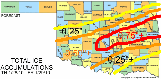
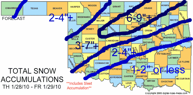
Here is my current personal forecast for the event. At the moment I am not going quite as extreme as the models, but I am still depicting a very severe storm for the area. A heavy glazing of ice followed by snow and gusty winds will likely lead to widespread downed trees, power outages, and impassable roads. It is not going to be pretty!

Image

Image

The following post is NOT an official forecast and should not be used as such. It is just the opinion of the poster and may or may not be backed by sound meteorological data. It is NOT endorsed by any professional institution including storm2k.org. For official information, please refer to NWS products.
Last edited by Extremeweatherguy on Wed Jan 27, 2010 12:57 am, edited 1 time in total.
0 likes   

Peanut432
Tropical Storm
Tropical Storm
Posts: 119
Joined: Mon Jan 25, 2010 10:21 pm
Location: Hollis Ok

#407 Postby Peanut432 » Wed Jan 27, 2010 12:41 am

I have to believe that the 1.5 freezing rain in OKC = some week long power outages
0 likes   

User avatar
somethingfunny
ChatStaff
ChatStaff
Posts: 3926
Age: 37
Joined: Thu May 31, 2007 10:30 pm
Location: McKinney, Texas

Re: Southern Plains winter wx thread (2009-2010)

#408 Postby somethingfunny » Wed Jan 27, 2010 1:11 am

I have never seen anything appraching 1.5" of freezing rain in my life. Maybe .25"-.5" during my worst ice storms. That would be horrific if it verifies. :eek:

Sure hope the Oklahoma National Guard is being mobilized, it sounds like they're going to be busy this weekend.
0 likes   

User avatar
Extremeweatherguy
Category 5
Category 5
Posts: 11095
Joined: Mon Oct 10, 2005 8:13 pm
Location: Florida

#409 Postby Extremeweatherguy » Wed Jan 27, 2010 1:18 am

What really makes the ice with this storm scary is the fact that there will be breezy winds throughout the event. Usually ice storms tend to be accompanied by fairly light winds, but not this one! The winds will help to add extra stress to the already ice loaded trees and power lines. This will mean a chance of horrific damage across the region if we see the freezing rain totals currently being predicted by the models.
0 likes   

Peanut432
Tropical Storm
Tropical Storm
Posts: 119
Joined: Mon Jan 25, 2010 10:21 pm
Location: Hollis Ok

#410 Postby Peanut432 » Wed Jan 27, 2010 1:35 am

The GFS cobb only show 2.6 inches of snow in Childress and .45 inch of sleet. Yet it has the total qpf at 1.66. Am i missing something? How much mostiure is in a .5 in of sleet?

The Nam on the other hand shows 1.30 of freezing rain :froze:
0 likes   

User avatar
Extremeweatherguy
Category 5
Category 5
Posts: 11095
Joined: Mon Oct 10, 2005 8:13 pm
Location: Florida

Re:

#411 Postby Extremeweatherguy » Wed Jan 27, 2010 1:42 am

Peanut432 wrote:The GFS cobb only show 2.6 inches of snow in Childress and .45 inch of sleet. Yet it has the total qpf at 1.66. Am i missing something? How much mostiure is in a .5 in of sleet?

The Nam on the other hand shows 1.30 of freezing rain :froze:
The other QPF is shown falling as normal rain before the temperature cools enough to support wintry precipitation according to the GFS. The NAM on the other hand brings the cold air in slightly faster and thus drops the freezing rain depicted on its output.
0 likes   

BlueIce
S2K Supporter
S2K Supporter
Posts: 194
Age: 37
Joined: Mon Sep 01, 2008 10:05 pm
Location: Oklahoma City, Oklahoma

Re:

#412 Postby BlueIce » Wed Jan 27, 2010 2:00 am

Extremeweatherguy wrote:What really makes the ice with this storm scary is the fact that there will be breezy winds throughout the event. Usually ice storms tend to be accompanied by fairly light winds, but not this one! The winds will help to add extra stress to the already ice loaded trees and power lines. This will mean a chance of horrific damage across the region if we see the freezing rain totals currently being predicted by the models.


Looks like emergency management is getting prepared for the event.

Koco.com wrote: OEM is working with FEMA to preposition industrial size generators in McAlester and Oklahoma City . The generators will be used in the event of power outages requiring shelters and to provide power to water treatment facilities in the event of electric service disruptions. The FEMA generators will augment the industrial size generators OEM already has positioned around the state
0 likes   

User avatar
Extremeweatherguy
Category 5
Category 5
Posts: 11095
Joined: Mon Oct 10, 2005 8:13 pm
Location: Florida

Re: Southern Plains winter wx thread (2009-2010)

#413 Postby Extremeweatherguy » Wed Jan 27, 2010 8:45 am

06z NAM cobb winter precipitation accumulation output...

OKLAHOMA CITY
Snow accumulation = 2.4"+
Sleet accumulation = 0.79"
Freezing rain accumulation = 2.36" :eek:

NORMAN
Snow accumulation = 1.8"+
Sleet accumulation = 0.44"
Freezing rain accumulation = 2.30" :eek:

06z GFS cobb winter precipitation accumulation output...

OKLAHOMA CITY
Snow accumulation = 9.4"
Sleet accumulation = 0.0"
Freezing rain accumulation = 1.05"

NORMAN
Snow accumulation = 4.8"
Sleet accumulation = 0.75"
Freezing rain accumulation = 0.85"


Overall I would say that the GFS totals look a little more realistic to me right now. The NAM verifying is not impossible though, and if it does then everyone needs to prepare for extreme damage. 2+ inches of ice plus wind would equal a top level extreme ice storm. The GFS thankfully is not as extreme, showing the snow/sleet line arriving sooner and thus ending the ice. The GFS is by no means "good" though. It is still showing about an inch or so of ice across most of the area, which with the wind would be capable of generating extensive tree damage.
0 likes   

Weatherdude20

Re: Southern Plains winter wx thread (2009-2010)

#414 Postby Weatherdude20 » Wed Jan 27, 2010 8:53 am

Wow, be careful Oklahoma, good luck national guard and Governer Henry.
0 likes   

msstateguy83

#415 Postby msstateguy83 » Wed Jan 27, 2010 9:19 am

if that low dont start going a bit more north or turn north there is gonna be probs to the south.. watchin it closely on sat image i know there is still plenty of time for a northward movement but i have not seen it yet...
0 likes   

User avatar
Extremeweatherguy
Category 5
Category 5
Posts: 11095
Joined: Mon Oct 10, 2005 8:13 pm
Location: Florida

Re: Southern Plains winter wx thread (2009-2010)

#416 Postby Extremeweatherguy » Wed Jan 27, 2010 11:08 am

Luckily the 12z NAM has come down just a bit in freezing rain totals. Instead of the incredible 2+ inch amounts that the 6z showed, the latest 12z run is closer to 1.00-1.25 inches of freezing rain. That would still be a very severe storm, especially with the wind, but not quite as "epic" as 2+ inches would be. Hopefully this trend toward less freezing rain continues.
0 likes   

brewskymc
Tropical Depression
Tropical Depression
Posts: 57
Joined: Mon Jan 05, 2009 5:49 pm
Location: Rowlett, TX

Re: Southern Plains winter wx thread (2009-2010)

#417 Postby brewskymc » Wed Jan 27, 2010 11:19 am

Extremeweatherguy wrote:Luckily the 12z NAM has come down just a bit in freezing rain totals. Instead of the incredible 2+ inch amounts that the 6z showed, the latest 12z run is closer to 1.00-1.25 inches of freezing rain. That would still be a very severe storm, especially with the wind, but not quite as "epic" as 2+ inches would be. Hopefully this trend toward less freezing rain continues.


True... I hope that those higher ice totals don't come to pass.
0 likes   

User avatar
Tireman4
S2K Supporter
S2K Supporter
Posts: 5853
Age: 59
Joined: Fri Jun 30, 2006 1:08 pm
Location: Humble, Texas
Contact:

#418 Postby Tireman4 » Wed Jan 27, 2010 12:30 pm

Stay safe folks.
0 likes   

msstateguy83

Re: Southern Plains winter wx thread (2009-2010)

#419 Postby msstateguy83 » Wed Jan 27, 2010 1:55 pm

LIVE WEATHER BRIEFING FROM KOCO TV CHIEF METEOROLOGIST RICK MITCHELL @ 1 PM

http://www.koco.com/video/22356041/index.html
0 likes   

User avatar
Extremeweatherguy
Category 5
Category 5
Posts: 11095
Joined: Mon Oct 10, 2005 8:13 pm
Location: Florida

Re: Southern Plains winter wx thread (2009-2010)

#420 Postby Extremeweatherguy » Wed Jan 27, 2010 2:17 pm

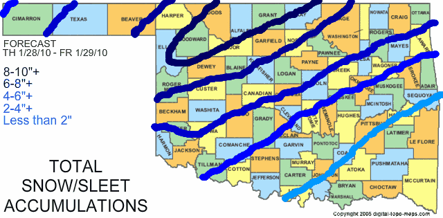
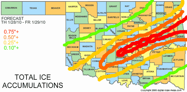
Here is my latest personal prediction for the storm...

Image

Image

It looks like the best chance for significant snows will be in northern and northwest Oklahoma, and the best chance for significant ice will be across central Oklahoma extending from the SW to the NE part of the state. There is likely to be a narrow strip of very significant icing within the larger ice storm zone, with amounts exceeding 0.75" within that corridor. Ice amounts of that magnitude coupled with breezy winds will likely cause significant damage to trees and power lines.


The following post is NOT an official forecast and should not be used as such. It is just the opinion of the poster and may or may not be backed by sound meteorological data. It is NOT endorsed by any professional institution including storm2k.org. For official information, please refer to NWS products.
0 likes   


Return to “Winter Weather”

Who is online

Users browsing this forum: No registered users and 18 guests