 Well it backed off a lot compared to the 12z run lol
Deep South Winterwx Discussion 2015-2016
Moderator: S2k Moderators
Forum rules
 The posts in this forum are NOT official forecast and should not be used as such. They are just the opinion of the poster and may or may not be backed by sound meteorological data. They are NOT endorsed by any professional institution or STORM2K.
 The posts in this forum are NOT official forecast and should not be used as such. They are just the opinion of the poster and may or may not be backed by sound meteorological data. They are NOT endorsed by any professional institution or STORM2K.
-
Metalicwx220
-
Metalicwx220
- Ivanhater
- Storm2k Moderator

- Posts: 11221
- Age: 39
- Joined: Fri Jul 01, 2005 8:25 am
- Location: Pensacola
Re: Deep South Winterwx thread: Mid February Warm-Up
Both Pensacola and Mobile broke a record high yesterday.
Looking at the latest GFS and Euro, there is no cold shot coming as the SE Ridge is too strong and shunts the cold air off to the north. Well have to see how this works out.
Looking at the latest GFS and Euro, there is no cold shot coming as the SE Ridge is too strong and shunts the cold air off to the north. Well have to see how this works out.
0 likes
Michael
Re: Deep South Winterwx thread: Mid February Warm-Up
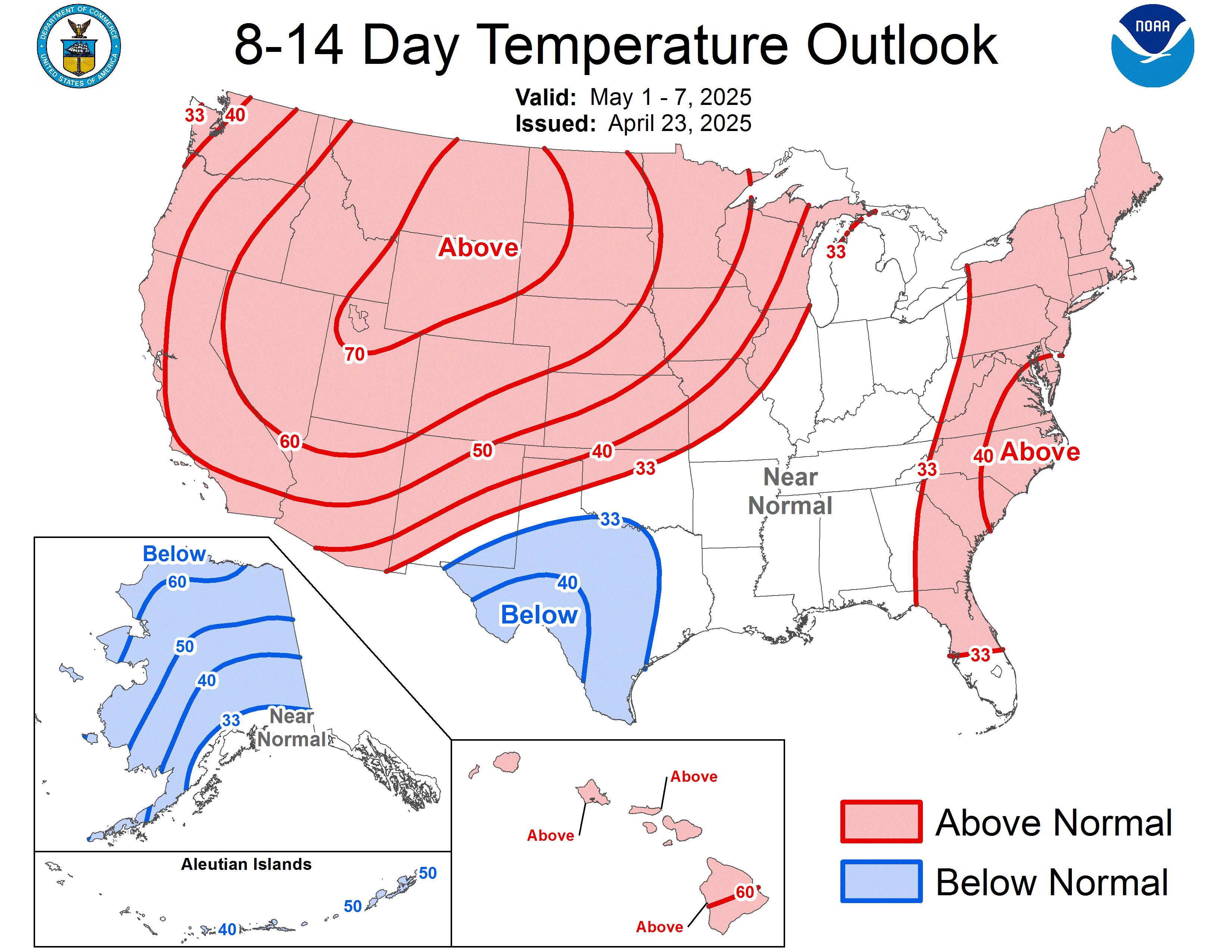
8-14 Day Temp Outlook shows continued above normal temps in the deep south.....once we move beyond march 5....barring an exceptional event like the superstorm of '93....all indications point to spring in these parts...but any cold fronts after March 5 south of I-10 are a gift.....we all know what awaits for month after month this summer...


0 likes
- MississippiWx
- S2K Supporter

- Posts: 1720
- Joined: Sat Aug 14, 2010 1:44 pm
- Location: Hattiesburg, Mississippi
Re: Deep South Winterwx thread: Mid February Warm-Up
A little off-topic, but not really...
The Southeast Ridge pattern that is setting up seems very ominous for the coming hurricane season. If it bridges with the A/B High, then we might see several tropical systems steered right into the heart of the Gulf of Mexico. Just something to keep you thinking during our warm spell.
The Southeast Ridge pattern that is setting up seems very ominous for the coming hurricane season. If it bridges with the A/B High, then we might see several tropical systems steered right into the heart of the Gulf of Mexico. Just something to keep you thinking during our warm spell.
0 likes
This post is not an official forecast and should not be used as such. It is just the opinion of MississippiWx and may or may not be backed by sound meteorological data. It is not endorsed by any professional institution including storm2k.org. For Official Information please refer to the NHC and NWS products.
- MGC
- S2K Supporter

- Posts: 5940
- Joined: Sun Mar 23, 2003 9:05 pm
- Location: Pass Christian MS, or what is left.
Re: Deep South Winterwx thread: Mid February Warm-Up
Yea, we need a pattern shift back to the EC trough by late July to November the back to SE ridge for the remainder of winter 11-12......MGC
0 likes
-
Metalicwx220
- northjaxpro
- S2K Supporter

- Posts: 8900
- Joined: Mon Sep 27, 2010 11:21 am
- Location: Jacksonville, FL
The large Southeastern U.S. ridge is really entrenched right now for sure. I was taking a look at those long range runs you posted above Metalicwx220 and I think it would take something strong and extreme to displace this ridge at this point. If it is going to happen, it won't be for at least another 10-12 days or so.
However, I still feel that we will get one last shot of cold weather into the Deep South during the first half of March. It seems to always happen every year.
However, I still feel that we will get one last shot of cold weather into the Deep South during the first half of March. It seems to always happen every year.
0 likes
NEVER, EVER SAY NEVER in the tropics and weather in general, and most importantly, with life itself!!
________________________________________________________________________________________
Fay 2008 Beryl 2012 Debby 2012 Colin 2016 Hermine 2016 Julia 2016 Matthew 2016 Irma 2017 Dorian 2019
________________________________________________________________________________________
Fay 2008 Beryl 2012 Debby 2012 Colin 2016 Hermine 2016 Julia 2016 Matthew 2016 Irma 2017 Dorian 2019
-
Metalicwx220
Yeah AccuWeather's long range forecast has us back in the 50s and 60s for highs. According to them a strong front will come through Wednesday March 2nd.
thunderstorms
Hi 80° RealFeel® 77° Day
SSW at 13 mph
Gusts: 28 mph
A couple of morning thunderstorms around; otherwise, partly sunny and very warm
Thunderstorm Probability: 60%
Amount of Precipitation: 0.02 in
Amount of Rain: 0.02 in
Amount of Snow: 0.0 in
Amount of Ice: 0.00 in
Hours of Precipitation: 2 hrs
Hours of Rain: 2 hrs
Rain
Lo 35° RealFeel® 32° Night
W at 8 mph
Gusts: 29 mph
Colder with rain
Thunderstorm Probability: 0%
Amount of Precipitation: 1.24 in
Amount of Rain: 1.24 in
Amount of Snow: 0.0 in
Amount of Ice: 0.00 in
Hours of Precipitation: 6 hrs
Thursday
Mar 3
Sunny and colder 60°Lo 35°
Friday
Mar 4
Mostly sunny 58°Lo 33°
Saturday
Mar 5
Sunshine 57°Lo 35°
Sunday
Mar 6
Plenty of clouds 58°Lo 36°
Monday
Mar 7
Sunshine 59°Lo 37°
0 likes
Re: Deep South Winterwx thread: Mid February Warm-Up
Our local channels are saying the same thing. Around the first of March (next week) the temps will drop but not as frigid cold as it was before. Just in time for Mardi Gras so I can freeze to death at the Ball. Grrr!
0 likes
-
Metalicwx220
Re: Deep South Winterwx thread: Mid February Warm-Up
Certainly a very nice weekend for the end of February. And yes it was quite warm today here in Baton Rouge and other areas of the Gulf Coast. Next Sunday we may struggle to reach 60. Almost certainly a couple of frosty mornings Monday, and perhaps Tuesday. While Mardi Gras day may start cool, it should warm by the afternoon.
0 likes
Who is online
Users browsing this forum: No registered users and 56 guests

 I assume a few flakes for central florida l don't know. I like the 12z run a whole lot better. I wonder what the 0z run will have.
 Winter is back for northern deep south. LOL


 OH MY GOD look at this! LOl Is this a mini version of a 1993 superstorm? Models can predict big storms well in advance. Could this be one?


 I find this interesting LOL but it is way out.


 Im tired of these snow maps so far out with snow in the deep south. Why did I even post this?
