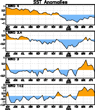
Last Week Numbers
Niño 4= +1.5ºC
Niño 3.4= +1.7ºC
Niño 3= +1.1ºC
Niño1+2= +0.3ºC
This Week Numbers
Niño 4= +1.4ºC
Niño 3.4= +1.4ºC
Niño 3= +0.8ºC
Niño1+2= +0.1ºC
http://www.cpc.ncep.noaa.gov/products/a ... ts-web.pdf

Moderator: S2k Moderators
 The posts in this forum are NOT official forecast and should not be used as such. They are just the opinion of the poster and may or may not be backed by sound meteorological data. They are NOT endorsed by any professional institution or STORM2K.


Ntxw wrote:One thing to note there is very cold air building and moving in northwest\central Canada.
Edit: This storm also wants to close off which could change some thingsvs the open wave it had prior.
BrokenGlass wrote:Ntxw, can you explain what you're saying in layman's terms for this relative noob:Ntxw wrote:One thing to note there is very cold air building and moving in northwest\central Canada.
Edit: This storm also wants to close off which could change some thingsvs the open wave it had prior.

The following post is NOT an official forecast and should not be used as such. It is just the opinion of the poster and may or may not be backed by sound meteorological data. It is NOT endorsed by any professional institution including storm2k.org. For official information, please refer to NWS products.

wxman57 wrote:It's not looking like much of a storm for NE TX (Dallas to Tyler). Moisture there decreases quickly after frontal passage. Have to go north of the Red River into Oklahoma for major problems. Farther north, say central OK to northeast OK and east of there through Arkansas/Tennessee/Kentucky and ENE could see heavy amounts.

Ntxw wrote:wxman57 wrote:It's not looking like much of a storm for NE TX (Dallas to Tyler). Moisture there decreases quickly after frontal passage. Have to go north of the Red River into Oklahoma for major problems. Farther north, say central OK to northeast OK and east of there through Arkansas/Tennessee/Kentucky and ENE could see heavy amounts.
I think that's quite an underestimate. Even without the winter precip the rain amounts would be no less to laugh about. And with falling temperatures anything left over would create icy problems overnight.
msstateguy83 wrote:ok sorry for the confusion.. my graphic was rushed and is BY NO MEANS perfect i would say more on the order
of no more then a quarter inch of ice for DFW.. but MAXED OUT AT NEAR 1 INCH along the redriver counties in southern ok & far
north tx..
The following post is NOT an official forecast and should not be used as such. It is just the opinion of the poster and may or may not be backed by sound meteorological data. It is NOT endorsed by any professional institution including storm2k.org. For official information, please refer to NWS products.

wxman57 wrote:It's not looking like much of a storm for NE TX (Dallas to Tyler). Moisture there decreases quickly after frontal passage. Have to go north of the Red River into Oklahoma for major problems. Farther north, say central OK to northeast OK and east of there through Arkansas/Tennessee/Kentucky and ENE could see heavy amounts.


msstateguy83 wrote:ok sorry for the confusion.. my graphic was rushed and is BY NO MEANS perfect i would say more on the order
of no more then a quarter inch of ice for DFW.. but MAXED OUT AT NEAR 1 INCH along the redriver counties in southern ok & far
north tx..
The following post is NOT an official forecast and should not be used as such. It is just the opinion of the poster and may or may not be backed by sound meteorological data. It is NOT endorsed by any professional institution including storm2k.org. For official information, please refer to NWS products.

wxman57 wrote:Ntxw wrote:wxman57 wrote:It's not looking like much of a storm for NE TX (Dallas to Tyler). Moisture there decreases quickly after frontal passage. Have to go north of the Red River into Oklahoma for major problems. Farther north, say central OK to northeast OK and east of there through Arkansas/Tennessee/Kentucky and ENE could see heavy amounts.
I think that's quite an underestimate. Even without the winter precip the rain amounts would be no less to laugh about. And with falling temperatures anything left over would create icy problems overnight.
Well, there could be some heavy rain in the warm air, that's true. But I see nothing to indicate an INCH of ice accumulation in the Dallas-Ft. Worth Metroplex. Models indicate that the precip shuts down fairly soon after frontal passage. For example, here's a plot of the 12Z GFS temps/dew points vs. 3-hr precip. Precip is over with by the time temps drop below freezing. And with a brisk NW wind, roads should dry off quickly after the precip ends. So maybe there would be some ice forming in any puddles in ditches, but it's not looking like a problem for roadways in the Dallas area.

Portastorm wrote:I know one thing ... if the 12z Euro from today were to verify ... locales in my part of the state would have a shot at some freezing precip. However, the model has a known bias for holding back too much low pressure and not being progressive enough.
Not getting my kicking shoes on just yet, Lucy! But if I'm living in Amarillo or Lubbock or Wichita Falls, I would be.
Users browsing this forum: South Texas Storms and 46 guests