Texas Winter 2012-2013

Winter Weather Discussion

Moderator: S2k Moderators

Forum rules

The posts in this forum are NOT official forecast and should not be used as such. They are just the opinion of the poster and may or may not be backed by sound meteorological data. They are NOT endorsed by any professional institution or STORM2K.

Help Support Storm2K
Message
Author
User avatar
~FlipFlopGirl~
Tropical Depression
Tropical Depression
Posts: 52
Age: 46
Joined: Sat Jul 24, 2010 7:43 pm
Location: Waco,TX

Re: Texas Winter 2012-2013

#421 Postby ~FlipFlopGirl~ » Sun Dec 02, 2012 6:54 pm

AggieSpirit wrote:Ladies and Gentlemen: Winter 2012/2013 has been cancelled. We are going to stick with quasi-fall weather through next March. Enjoy many 75+ degree days to come!


NOOOOO....... My poor yard looks so confused- Piles of leaves yet bright green as a summer day- :sun:
0 likes   

User avatar
wxman57
Moderator-Pro Met
Moderator-Pro Met
Posts: 22978
Age: 67
Joined: Sat Jun 21, 2003 8:06 pm
Location: Houston, TX (southwest)

Re:

#422 Postby wxman57 » Sun Dec 02, 2012 9:07 pm

SaskatchewanScreamer wrote:I can tell there weren't any farmers/ranchers in your family Wxman. ;)

Strange how your area of Houston has done so well and other areas haven't.


No farmers in Houston. The rest of Texas could use a good bit of rain, particularly central parts of the state.
0 likes   

User avatar
Ntxw
Storm2k Moderator
Storm2k Moderator
Posts: 22785
Joined: Wed Oct 21, 2009 6:34 pm
Location: DFW, Texas

#423 Postby Ntxw » Sun Dec 02, 2012 9:57 pm

HPC had a great discussion today regarding the changes that are occurring/will occur. Question will be if the pattern holds and we get a prolonged period to round out the month or will things be transient?

_____________________________
EXTENDED FORECAST DISCUSSION
NWS HYDROMETEOROLOGICAL PREDICTION CENTER COLLEGE PARK MD
230 PM EST SUN DEC 02 2012

VALID 12Z WED DEC 05 2012 - 12Z SUN DEC 09 2012

...SYNOPSIS...

THE WESTERN U.S. STORM RELAXES DURING THE MEDIUM RANGE PERIOD. IN
THE EASTERN U.S...A SLOW MOVING FRONT WILL BRING A CHANCE OF RAIN
AND POSSIBLY A ZONE OF WINTRY MIX BY NEXT WEEKEND.

THE MEDIUM RANGE FORECAST FEATURES A GRADUAL CHANGE IN THE LARGE
SCALE PATTERN. A LONG-LIVED REX BLOCK AND SPLIT FLOW REGIME NEAR
AND SOUTH OF THE ALEUTIAN ISLANDS WILL BREAK DOWN. THIS ALLOWS
MORE COLD AIR TO SPILL OFF OF CONTINENTAL ASIA AND DEEPEN A
LONGWAVE TROUGH OVER THE CENTRAL PACIFIC. THIS...IN TURN...PROPS
UP A DOWNSTREAM RIDGE OVER THE EASTERN PACIFIC...BRINGING AN END
TO THE PROLONGED HEAVY RAIN EVENT ALONG THE WEST COAST OF THE U.S.
FARTHER DOWNSTREAM INTO NORTH AMERICA...MODELS AND TELECONNECTIONS
PREDICT DEVELOPMENT OF A BROAD SCALE POSITIVELY TILTED
TROUGH...SUPPORTED BY INTRUSIONS OF ARCTIC AND MODIFIED ARCTIC AIR
INTO THE CENTRAL/EASTERN STATES.
0 likes   
The above post and any post by Ntxw is NOT an official forecast and should not be used as such. It is just the opinion of the poster and may or may not be backed by sound meteorological data. It is NOT endorsed by any professional institution including Storm2k. For official information, please refer to NWS products.

  Help support Storm2K!
Help Support Storm2K

SaskatchewanScreamer

#424 Postby SaskatchewanScreamer » Sun Dec 02, 2012 11:20 pm

re A/C I have to ask if this is true. An Albertan that goes to Houston often says the A/C is set so cold down there that people's glasses fog up when they go outside??? That would be the exact opposite of here (come winter).
0 likes   

User avatar
Ntxw
Storm2k Moderator
Storm2k Moderator
Posts: 22785
Joined: Wed Oct 21, 2009 6:34 pm
Location: DFW, Texas

#425 Postby Ntxw » Sun Dec 02, 2012 11:32 pm

GFS/Canadian and somewhat Euro all suggest/trend that we may see our first legit major winter storm threat around the 10th or just after.

http://mag.ncep.noaa.gov/NCOMAGWEB/appc ... mageSize=M
0 likes   
The above post and any post by Ntxw is NOT an official forecast and should not be used as such. It is just the opinion of the poster and may or may not be backed by sound meteorological data. It is NOT endorsed by any professional institution including Storm2k. For official information, please refer to NWS products.


  Help support Storm2K!

Help Support Storm2K


Shoshana
Category 5
Category 5
Posts: 1414
Joined: Thu Sep 09, 2004 7:50 pm
Location: NE Austin

Re:

#426 Postby Shoshana » Sun Dec 02, 2012 11:35 pm

SaskatchewanScreamer wrote:re A/C I have to ask if this is true. An Albertan that goes to Houston often says the A/C is set so cold down there that people's glasses fog up when they go outside??? That would be the exact opposite of here (come winter).


Houston is really humid, I wouldn't be surprised that glasses would fog. Buildings aren't as cold as they used to be in summer though, not since the threat of rolling blackouts.
0 likes   

User avatar
cheezyWXguy
Category 5
Category 5
Posts: 6108
Joined: Mon Feb 13, 2006 12:29 am
Location: Dallas, TX

Re:

#427 Postby cheezyWXguy » Mon Dec 03, 2012 1:00 am

Ntxw wrote:GFS/Canadian and somewhat Euro all suggest/trend that we may see our first legit major winter storm threat around the 10th or just after.

http://mag.ncep.noaa.gov/NCOMAGWEB/appc ... mageSize=M

Yeah, really looks like it, and it also sets up another big surge of arctic air later in the period too. of course thats just fantasy land, but it does sort of give the idea that this pattern change may stick around for a bit.
0 likes   

User avatar
Rgv20
S2K Supporter
S2K Supporter
Posts: 2466
Age: 38
Joined: Wed Jan 05, 2011 5:42 pm
Location: Edinburg/McAllen Tx

#428 Postby Rgv20 » Mon Dec 03, 2012 1:22 am

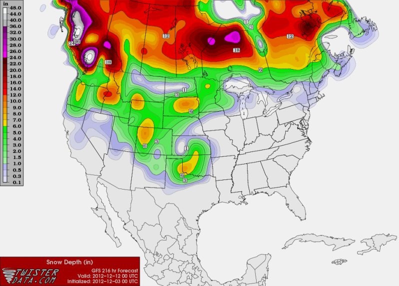
0zGFS brings some Winter fun for North and the Panhandle of Texas in 9 to 10 days (December 11th) from now. 12zECMWF forecast a light dusting of snow for the Panhandle, going to be interesting what the 0z shows tonight.

Image
0 likes   
The following post is NOT an official forecast and should not be used as such. It is just the opinion of the poster and may or may not be backed by sound meteorological data. It is NOT endorsed by any professional institution including storm2k.org For Official Information please refer to the NHC and NWS products.

User avatar
gboudx
S2K Supporter
S2K Supporter
Posts: 4080
Joined: Thu Sep 04, 2003 1:39 pm
Location: Rockwall, Tx but from Harvey, La

Re: Texas Winter 2012-2013

#429 Postby gboudx » Mon Dec 03, 2012 8:06 am

From DFW NWS:

Image
Texas has been in a very warm weather pattern for the last two weeks, but big changes are on the way. The extended period of warm weather is because an upper level low has been stationary over the northeast Pacific Ocean which has kept cold air bottled up in Canada. The upper level low is forecast to move across the United States this weekend and early next week, which will allow the cold air to head south. Just how cold will it get for North Texas? Right now it looks like low temps will be in the 20s and highs may only be in the 40s by next Tuesday. Stayed tuned for further updates as we will be closely watching how this system evolves.
0 likes   

User avatar
wxman57
Moderator-Pro Met
Moderator-Pro Met
Posts: 22978
Age: 67
Joined: Sat Jun 21, 2003 8:06 pm
Location: Houston, TX (southwest)

Re: Texas Winter 2012-2013

#430 Postby wxman57 » Mon Dec 03, 2012 9:00 am

It's a change from the 80s next week, but nothing major. Should bring our temps closer to normal for the 2nd week of December - at least for a few days.
0 likes   

User avatar
Portastorm
Storm2k Moderator
Storm2k Moderator
Posts: 9914
Age: 63
Joined: Fri Jul 11, 2003 9:16 am
Location: Round Rock, TX
Contact:

Re: Texas Winter 2012-2013

#431 Postby Portastorm » Mon Dec 03, 2012 11:12 am

wxman57 wrote:It's a change from the 80s next week, but nothing major. Should bring our temps closer to normal for the 2nd week of December - at least for a few days.


Uh ... not really there HeatMiser. The 0z GFS output numbers for Austin next week show high temperatures by midweek lowering to about 5-8 degrees below normal. Early in the week the temps would be close to normal.

And I guess you didn't see the forecast discussion out of the NWS office in Fort Worth. With progged high temps in the 30s or 40s next Tuesday that is well below normal for the DFW metroplex.

Look, we know this will be hard on you, especially after you ruled last "winter." But it's gonna be ok. You can make it through the next few months and warm temperatures will return to make you happy. :cheesy:
0 likes   
Any forecasts under my name are to be taken with a grain of salt. Get your best forecasts from the National Weather Service and National Hurricane Center.

User avatar
Ntxw
Storm2k Moderator
Storm2k Moderator
Posts: 22785
Joined: Wed Oct 21, 2009 6:34 pm
Location: DFW, Texas

#432 Postby Ntxw » Mon Dec 03, 2012 1:07 pm

Wxman57 is sort of right in that this is not likely to be any earth shattering arctic attack since it's not going to be +PNA/-EPO connect, likely a +EPO. But it will be the front end of a major pattern shift and air will be cold enough and dig a short wave deep enough to bring early season fun and games! And more importantly, the height rises in the East Pacific bodes much better for odds of rain.

However it is still 7 days away so can only guess on temps and possibilities of frozen precip to any confidence!
0 likes   
The above post and any post by Ntxw is NOT an official forecast and should not be used as such. It is just the opinion of the poster and may or may not be backed by sound meteorological data. It is NOT endorsed by any professional institution including Storm2k. For official information, please refer to NWS products.


  Help support Storm2K!

Help Support Storm2K


User avatar
Portastorm
Storm2k Moderator
Storm2k Moderator
Posts: 9914
Age: 63
Joined: Fri Jul 11, 2003 9:16 am
Location: Round Rock, TX
Contact:

Re: Texas Winter 2012-2013

#433 Postby Portastorm » Mon Dec 03, 2012 1:12 pm

Time for me to change the ol' avatar and offset any effects which the HeatMiser is planning!
0 likes   
Any forecasts under my name are to be taken with a grain of salt. Get your best forecasts from the National Weather Service and National Hurricane Center.

User avatar
gboudx
S2K Supporter
S2K Supporter
Posts: 4080
Joined: Thu Sep 04, 2003 1:39 pm
Location: Rockwall, Tx but from Harvey, La

Re: Texas Winter 2012-2013

#434 Postby gboudx » Mon Dec 03, 2012 1:31 pm

Portastorm wrote:Time for me to change the ol' avatar and offset any effects which the HeatMiser is planning!


I went ahead and changed mine too, though I did enjoy the 10 mile ride on my mountain bike yesterday with temps in the upper-70's. However, I have cold gear clothes that I'm itching to use.
0 likes   

User avatar
Portastorm
Storm2k Moderator
Storm2k Moderator
Posts: 9914
Age: 63
Joined: Fri Jul 11, 2003 9:16 am
Location: Round Rock, TX
Contact:

Re: Texas Winter 2012-2013

#435 Postby Portastorm » Mon Dec 03, 2012 1:43 pm

:uarrow:

Somehow, some way ... this has to usher in some good, winter-luvin' karma! :lol:

Meanwhile, I'm here to report that the 12z GFS forecast numbers for Austin next week are even colder than the 0z run. Highs in the low 50s for several days. Not saying it will verify but it's interesting to note the trend.
0 likes   
Any forecasts under my name are to be taken with a grain of salt. Get your best forecasts from the National Weather Service and National Hurricane Center.

User avatar
Ntxw
Storm2k Moderator
Storm2k Moderator
Posts: 22785
Joined: Wed Oct 21, 2009 6:34 pm
Location: DFW, Texas

Re: Texas Winter 2012-2013

#436 Postby Ntxw » Mon Dec 03, 2012 1:46 pm

I see that the euro has been bending to the GFS even today. It was late to the party on showing the change just a few days ago, so if anyone is keeping records make note! ECMWF has done 180s day to day.
0 likes   
The above post and any post by Ntxw is NOT an official forecast and should not be used as such. It is just the opinion of the poster and may or may not be backed by sound meteorological data. It is NOT endorsed by any professional institution including Storm2k. For official information, please refer to NWS products.


  Help support Storm2K!

Help Support Storm2K


User avatar
wxman57
Moderator-Pro Met
Moderator-Pro Met
Posts: 22978
Age: 67
Joined: Sat Jun 21, 2003 8:06 pm
Location: Houston, TX (southwest)

Re: Texas Winter 2012-2013

#437 Postby wxman57 » Mon Dec 03, 2012 2:04 pm

Portastorm wrote:
wxman57 wrote:It's a change from the 80s next week, but nothing major. Should bring our temps closer to normal for the 2nd week of December - at least for a few days.


Uh ... not really there HeatMiser. The 0z GFS output numbers for Austin next week show high temperatures by midweek lowering to about 5-8 degrees below normal. Early in the week the temps would be close to normal.

And I guess you didn't see the forecast discussion out of the NWS office in Fort Worth. With progged high temps in the 30s or 40s next Tuesday that is well below normal for the DFW metroplex.

Look, we know this will be hard on you, especially after you ruled last "winter." But it's gonna be ok. You can make it through the next few months and warm temperatures will return to make you happy. :cheesy:


I was looking at the GFS runs from a week ago predicting very cold temps across TX tomorrow and Wednesday (lows in the 30s). Turns out the GFS was about 15 degrees too cool with tomorrow's front. Let's see how it does with next week's front. I agree, the pattern does indicate lows in the 30s for the middle of next week. Maybe a bit below normal, but I don't see anything to suggest that the cold will last more than a few days. Nothing to suggest any major push of cold air out of western Canada next week or the week after.

Note - the 12Z Euro has quite a different flow pattern than the GFS for later this week through next Wednesday. It has a weak cold front moving through SE TX on Sunday while the GFS has nothing moving through. Then the GFS moves the big upper low across Texas next Tue while the Euro has it stationary well west of TX, indicating not much cold air here.
0 likes   

User avatar
Portastorm
Storm2k Moderator
Storm2k Moderator
Posts: 9914
Age: 63
Joined: Fri Jul 11, 2003 9:16 am
Location: Round Rock, TX
Contact:

Re: Texas Winter 2012-2013

#438 Postby Portastorm » Mon Dec 03, 2012 2:23 pm

:uarrow:

You and I both know that I've fallen on my backside plenty of times (ala Charlie Brown with Lucy) trusting the GFS this far out!

I'm somewhat optimistic temps will cool to seasonal or slightly below but I'm not expecting an Arctic Outbreak either. And yes, the cooler/colder temps don't look to stay around very long. You'll see the "confidence is high" posting from the Portastorm Weather Center come this Friday if things still look promising.
0 likes   
Any forecasts under my name are to be taken with a grain of salt. Get your best forecasts from the National Weather Service and National Hurricane Center.

User avatar
CaptinCrunch
S2K Supporter
S2K Supporter
Posts: 8728
Age: 57
Joined: Mon Nov 03, 2003 4:33 pm
Location: Kennedale, TX (Tarrant Co.)

Re: Texas Winter 2012-2013

#439 Postby CaptinCrunch » Mon Dec 03, 2012 2:25 pm

Well it's been a long time since I was last here, hope everyone has been doing good. Now with a little WINTER hope.

This is the last part of this afternoons AFD from the NWS FTW


HOWEVER...BIG CHANGES ARE ON THE WAY AS THE LARGE UPPER LEVEL
CYCLONE THAT HAS MADE ITS HOME OVER THE GULF OF ALASKA FOR THE
LAST 2 WEEKS GETS KICKED EASTWARD AND ONSHORE BY THE WEEKEND. AS
THE TROUGH HEADS EAST ACROSS THE CONUS...IT WILL UNLEASH ARCTIC
AIR THAT HAS BEEN BOTTLED UP OVER WESTERN CANADA FOR MOST OF
NOVEMBER. THIS UPPER PATTERN IS NOT ANYTHING SPECIAL OR UNIQUE FOR
COLD AIR INTRUSIONS...SO RECORD COLD IS OUT OF THE QUESTION.
HOWEVER THE AIR THE TROUGH TAPS INTO IS FAIRLY COLD AND WILL
CAUSE A QUICK ARRIVAL OF WINTER TYPE WEATHER EARLY NEXT WEEK. THE
00Z GFS DIGS THE UPPER LEVEL ENERGY INTO THE INTER-MOUNTAIN WEST
WHICH HOLDS UP THE FRONT ABOUT A DAY BUT WOULD INCREASE THE CHANCE
OF FROZEN PRECIP. AS OF NOW THE 00Z GFS IS THE OUTLIER...AND THE
ECMWF OFFERS A GOOD COMPROMISE OF 500MB PATTERNS SHOWN BY THE
UKMET...CANADIAN...AND GFS ENSEMBLE MEAN. SO ALL OF THIS POINTS
TO THE COLD FRONT ARRIVING MONDAY...12-24 HOURS FASTER THAN THE
CURRENT 00Z GFS. WINTER PRECIP CANT BE RULED OUT...BUT RIGHT NOW
IT IS A VERY LOW PROBABILITY EVENT. EITHER WAY...TEMPS WILL FALL
DURING THE DAY MONDAY WITH LOWS IN THE 20S BY TUESDAY
MORNING...AND HIGHS TUESDAY LIKELY STUCK IN THE 30S OR 40S.
0 likes   

weatherguy425
Tropical Storm
Tropical Storm
Posts: 180
Joined: Sun Aug 16, 2009 1:06 pm
Location: Houston, TX > Lubbock, TX > Savannah, GA
Contact:

Re: Texas Winter 2012-2013

#440 Postby weatherguy425 » Mon Dec 03, 2012 2:41 pm

At the very least I expect these spring-like temps to end. There's cold air consistently in northwestern Canada and when the Alaskan vortex finally fades and the pna goes positive...I would think such a zonal pattern wouldn't be as likely.
0 likes   


Return to “Winter Weather”

Who is online

Users browsing this forum: No registered users and 9 guests