
Tyler TAF has freezing rain for 6 hours, then ice pellets. 6 hours isn't enough time for serious ice buildup, is it? If it rains too hard, doesn't warmer air get drawn down, or if it's really dry, cooled below freezing?
Our place between mineola and Gilmer has large pines everywhere
Texas Winter 2025-2026
Moderator: S2k Moderators
Forum rules
 The posts in this forum are NOT official forecast and should not be used as such. They are just the opinion of the poster and may or may not be backed by sound meteorological data. They are NOT endorsed by any professional institution or STORM2K.

The posts in this forum are NOT official forecast and should not be used as such. They are just the opinion of the poster and may or may not be backed by sound meteorological data. They are NOT endorsed by any professional institution or STORM2K.
Re: Texas Winter 2025-2026
0 likes
-
Yukon Cornelius
- S2K Supporter

- Posts: 1838
- Age: 42
- Joined: Thu Dec 20, 2012 9:23 pm
- Location: Dean, TX/Westcliffe, CO
Re: Texas Winter 2025-2026
wxman22 wrote:No surprise but Norman has now upped snowfall amounts in WF to the 4-6 inch range.
https://i.ibb.co/DP2pz415/IMG-0623.jpg
I figured it was only a matter of time.
1 likes
#neversummer
-
cheezyWXguy

- Category 5

- Posts: 6282
- Joined: Mon Feb 13, 2006 12:29 am
- Location: Dallas, TX
Re: Texas Winter 2025-2026
Ralph's Weather wrote:Latest HRRR is pretty good on the initial post frontal temps but it is around 4F too warm with the secondary push locates in the northern Panhandle through far north OK.
I’m only just eyeballing it since I’m on mobile atm, but it looks like the freezing line on the doorstep of Wichita Falls and Ardmore. 17z hrrr depiction for 1pm looks like it’s a fair bit north of there
2 likes
-
TomballEd
- Category 5
- Posts: 1268
- Age: 62
- Joined: Wed Aug 16, 2023 4:52 pm
- Location: Spring/Klein area, not Tomball
Re: Texas Winter 2025-2026
Just looked at the total freezing rain totals off the GFS, 0.11 inches for IAH in about a nine hour prediod Sunday morning. Which is big deal for anyone driving where roads haven't been treated. May be enough liquid rain to wash of the CaCl2 unless they reapply within a few hours of the changeover.
I'm sure the exact amounts are fluid but somewhere on the I-35 corridor somewhere near Mexico they will be power pole snapping precipitation. Look at the Southern US...

I'm sure the exact amounts are fluid but somewhere on the I-35 corridor somewhere near Mexico they will be power pole snapping precipitation. Look at the Southern US...
0 likes
-
Yukon Cornelius
- S2K Supporter
- Posts: 1838
- Age: 42
- Joined: Thu Dec 20, 2012 9:23 pm
- Location: Dean, TX/Westcliffe, CO
Re: Texas Winter 2025-2026
cheezyWXguy wrote:Ralph's Weather wrote:Latest HRRR is pretty good on the initial post frontal temps but it is around 4F too warm with the secondary push locates in the northern Panhandle through far north OK.
I’m only just eyeballing it since I’m on mobile atm, but it looks like the freezing line on the doorstep of Wichita Falls and Ardmore. 17z hrrr depiction for 1pm looks like it’s a fair bit north of there
We’re close in WF. It’s currently 33. With the way it’s been dropping we’ll probably be below freezing within the next 30 min or so.
4 likes
#neversummer

Re: Texas Winter 2025-2026
Interesting watching the OK Mesonet observations this morning. Areas E and SE from Tulsa have seen their temps rise through the morning. Even Tulsa has had a slow creep up from their lows around 4 hours ago. The temp decrease further west (and even SW) from there has been steady. With NE/NNE winds will that advect down in DFW area and slow the temp drop?
0 likes
-
rwfromkansas
- Category 5
- Posts: 3028
- Joined: Sat Aug 27, 2005 12:47 am
- Location: North Fort Worth
Re: Texas Winter 2025-2026
Watching a video from Texas Storm Chasers, and they are definitely ramping up the talk of more icing further south. Seeing their HRRR run posted, it looks like may be some brief changeovers to snow in the morning for parts of DFW before going back to sleet.
3 likes

Re: Texas Winter 2025-2026
Yukon Cornelius wrote:cheezyWXguy wrote:Ralph's Weather wrote:Latest HRRR is pretty good on the initial post frontal temps but it is around 4F too warm with the secondary push locates in the northern Panhandle through far north OK.
I’m only just eyeballing it since I’m on mobile atm, but it looks like the freezing line on the doorstep of Wichita Falls and Ardmore. 17z hrrr depiction for 1pm looks like it’s a fair bit north of there
We’re close in WF. It’s currently 33. With the way it’s been dropping we’ll probably be below freezing within the next 30 min or so.
Is that ahead, behind or on schedule with most of the models?
0 likes
Any forecast I make is based on my opinion only. Please refer to the NWS or NHC for official forecasts.
-
Iceresistance

- Category 5
- Posts: 9579
- Age: 22
- Joined: Sat Oct 10, 2020 9:45 am
- Location: Tecumseh, OK/Norman, OK
Re: Texas Winter 2025-2026
You can't be this serious HRRR, Thundersnow!?

https://s12.gifyu.com/images/bk914.png

https://s12.gifyu.com/images/bk918.png
https://s12.gifyu.com/images/bk914.png
https://s12.gifyu.com/images/bk918.png
3 likes
Bill 2015 & Beta 2020
Winter 2020-2021
All observations are in Tecumseh, OK unless otherwise noted.
Winter posts are focused mainly for Oklahoma & Texas.
Take any of my forecasts with a grain of salt, refer to the NWS, SPC, and NHC for official information
Never say Never with weather! Because ANYTHING is possible!
Winter 2020-2021
All observations are in Tecumseh, OK unless otherwise noted.
Winter posts are focused mainly for Oklahoma & Texas.
Take any of my forecasts with a grain of salt, refer to the NWS, SPC, and NHC for official information
Never say Never with weather! Because ANYTHING is possible!
-
ThunderSleetDreams

- S2K Supporter
- Posts: 1510
- Age: 43
- Joined: Tue Dec 20, 2011 4:42 pm
- Location: S of Weimar, TX
Re: Texas Winter 2025-2026
HGX issues Winter Storm Warnings.
The map looks like 2021 all over again.
The map looks like 2021 all over again.
3 likes
#NeverSummer
I hibernate when it gets above 75 degrees!
I hibernate when it gets above 75 degrees!
-
rwfromkansas
- Category 5
- Posts: 3028
- Joined: Sat Aug 27, 2005 12:47 am
- Location: North Fort Worth
Re: Texas Winter 2025-2026
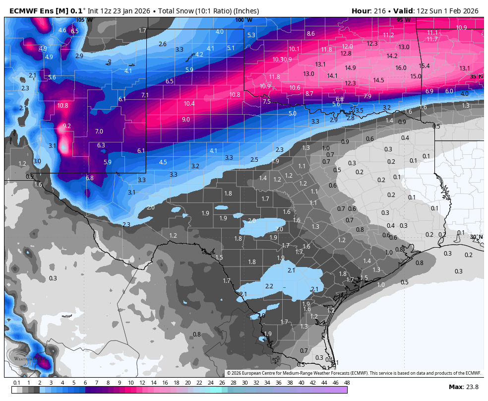
txtwister78 wrote:Bullish signal right there also coming from Euro ENS when you're still 7 days out.
https://images.weatherbell.com/model/ecmwf-ensemble-avg/tx/total_snow_10to1/1769169600/1769947200-3d0UjiQ6FaY.png
Well I wish that was further south to match the other models, but will see. Oh oops nevermind that's total snowfall for the entire time so showing the current storm. But yes, that's exciting to see some snow further south.
0 likes
-
Yukon Cornelius
- S2K Supporter
- Posts: 1838
- Age: 42
- Joined: Thu Dec 20, 2012 9:23 pm
- Location: Dean, TX/Westcliffe, CO
Re: Texas Winter 2025-2026
Snowman67 wrote:Yukon Cornelius wrote:cheezyWXguy wrote:I’m only just eyeballing it since I’m on mobile atm, but it looks like the freezing line on the doorstep of Wichita Falls and Ardmore. 17z hrrr depiction for 1pm looks like it’s a fair bit north of there
We’re close in WF. It’s currently 33. With the way it’s been dropping we’ll probably be below freezing within the next 30 min or so.
Is that ahead, behind or on schedule with most of the models?
I could be wrong but from what I’ve kind of been tracking and have seen it’s ahead of schedule.
2 likes
#neversummer
Re: Texas Winter 2025-2026
DallasAg wrote:Interesting watching the OK Mesonet observations this morning. Areas E and SE from Tulsa have seen their temps rise through the morning. Even Tulsa has had a slow creep up from their lows around 4 hours ago. The temp decrease further west (and even SW) from there has been steady. With NE/NNE winds will that advect down in DFW area and slow the temp drop?
Yeah looking at the SPC Mesoanalysis, the freezing line is roughly located along a line from NW Texas to EC Oklahoma (SW to NE oriented), and then east across northern Arkansas (W to E oriented). With the prevailing surface winds from the northeast, it will take longer to cool off in NC and NE Texas and we have to deal with the Ouachita mountains shadow effect which will slow it down some.
However, I think the models seem to be representing this fairly accurately. The eastern part of the cold front seems to be slow initially, before pushing more quickly south/southwest into the evening hours. The 18Z HRRR shows DFW at freezing around 2 am which is close to what everyone is saying. Sometime around or after midnight.
You can see how this is happening in real time currently with the 3 hour temp change depiction, with NW Texas in an area of stronger low level flow and a drop of -6F. Areas to the east are holding steady or only slightly dropping where the front is.
1 likes


Re: Texas Winter 2025-2026
cstrunk wrote:DallasAg wrote:Interesting watching the OK Mesonet observations this morning. Areas E and SE from Tulsa have seen their temps rise through the morning. Even Tulsa has had a slow creep up from their lows around 4 hours ago. The temp decrease further west (and even SW) from there has been steady. With NE/NNE winds will that advect down in DFW area and slow the temp drop?
Yeah looking at the SPC Mesoanalysis, the freezing line is roughly located along a line from NW Texas to EC Oklahoma (SW to NE oriented), and then east across northern Arkansas (W to E oriented). With the prevailing surface winds from the northeast, it will take longer to cool off in NC and NE Texas and we have to deal with the Ouachita mountains shadow effect which will slow it down some.
However, I think the models seem to be representing this fairly accurately. The eastern part of the cold front seems to be slow initially, before pushing more quickly south/southwest into the evening hours. The 18Z HRRR shows DFW at freezing around 2 am which is close to what everyone is saying. Sometime around or after midnight.
You can see how this is happening in real time currently with the 3 hour temp change depiction, with NW Texas in an area of stronger low level flow and a drop of -6F. Areas to the east are holding steady or only slightly dropping where the front is.
With N/NE winds the air is having to move uphill from the northeast to southwest. Of course the Ouachita just adds to that climb. Area from Western Kansas down to W-Texas is all downhill. If this were NW cold front with high centered squarely in Montana the I-35 corridor would be dropping precipitously.
It isn't just the Ouachita, the Ozarks are also a rise in southwest MO. These two areas of rise slows surface cold some.

6 likes
The above post and any post by Ntxw is NOT an official forecast and should not be used as such. It is just the opinion of the poster and may or may not be backed by sound meteorological data. It is NOT endorsed by any professional institution including Storm2k. For official information, please refer to NWS products.
Help support Storm2K!
-
Ralph's Weather
- S2K Supporter
- Posts: 3371
- Age: 38
- Joined: Fri Dec 13, 2013 11:55 am
- Location: Lindale, TX
- Contact:
Re: Texas Winter 2025-2026
Ntxw wrote:cstrunk wrote:DallasAg wrote:Interesting watching the OK Mesonet observations this morning. Areas E and SE from Tulsa have seen their temps rise through the morning. Even Tulsa has had a slow creep up from their lows around 4 hours ago. The temp decrease further west (and even SW) from there has been steady. With NE/NNE winds will that advect down in DFW area and slow the temp drop?
Yeah looking at the SPC Mesoanalysis, the freezing line is roughly located along a line from NW Texas to EC Oklahoma (SW to NE oriented), and then east across northern Arkansas (W to E oriented). With the prevailing surface winds from the northeast, it will take longer to cool off in NC and NE Texas and we have to deal with the Ouachita mountains shadow effect which will slow it down some.
However, I think the models seem to be representing this fairly accurately. The eastern part of the cold front seems to be slow initially, before pushing more quickly south/southwest into the evening hours. The 18Z HRRR shows DFW at freezing around 2 am which is close to what everyone is saying. Sometime around or after midnight.
You can see how this is happening in real time currently with the 3 hour temp change depiction, with NW Texas in an area of stronger low level flow and a drop of -6F. Areas to the east are holding steady or only slightly dropping where the front is.
With N/NE winds the air is having to move uphill from the northeast to southwest. Of course the Ouachita just adds to that climb. Area from Western Kansas down to W-Texas is all downhill. If this were NW cold front with high centered squarely in Montana the I-35 corridor would be dropping precipitously.
One interesting thing I see in the Hi Res is there is enough of an easterly component that freezing temps slide in to Texarkana and I-30 corridor by this evening while it takes until after midnight for DFW all the way up to Ft Smith, AR. I do not recall seeing that happen before at least not on this scale. Rarely do we get strong enough CAA from a Great Lakes centered trough to see that but with the lowering pressures over W TX it is pulling that cold air in at an unusual trajectory. Being downwind of the mountains has a huge affect on CAA.
3 likes
Follow on Facebook at Ralph's Weather.


-
Stratton23
- Category 5
- Posts: 3525
- Joined: Fri Jul 21, 2023 10:59 pm
- Location: Katy, Tx
Re: Texas Winter 2025-2026
18z HRRR looks like its hinting at a couple of heavy snow bands/ and sleet in se texas, very interesting, its not all ice
4 likes
-
bubba hotep

- S2K Supporter
- Posts: 6013
- Joined: Wed Dec 28, 2016 1:00 am
- Location: Collin County Texas
Re: Texas Winter 2025-2026
18z HRRR brings the hammer down.


4 likes
Winter time post are almost exclusively focused on the DFW area.

Re: Texas Winter 2025-2026
... yikes. This is looking like a fairly significant ice storm for a lot of the state. Maybe not crippling levels, but definitely moderate impacts for lots of people.
2 likes
Re: Texas Winter 2025-2026
Ntxw wrote:cstrunk wrote:DallasAg wrote:Interesting watching the OK Mesonet observations this morning. Areas E and SE from Tulsa have seen their temps rise through the morning. Even Tulsa has had a slow creep up from their lows around 4 hours ago. The temp decrease further west (and even SW) from there has been steady. With NE/NNE winds will that advect down in DFW area and slow the temp drop?
Yeah looking at the SPC Mesoanalysis, the freezing line is roughly located along a line from NW Texas to EC Oklahoma (SW to NE oriented), and then east across northern Arkansas (W to E oriented). With the prevailing surface winds from the northeast, it will take longer to cool off in NC and NE Texas and we have to deal with the Ouachita mountains shadow effect which will slow it down some.
However, I think the models seem to be representing this fairly accurately. The eastern part of the cold front seems to be slow initially, before pushing more quickly south/southwest into the evening hours. The 18Z HRRR shows DFW at freezing around 2 am which is close to what everyone is saying. Sometime around or after midnight.
You can see how this is happening in real time currently with the 3 hour temp change depiction, with NW Texas in an area of stronger low level flow and a drop of -6F. Areas to the east are holding steady or only slightly dropping where the front is.
With N/NE winds the air is having to move uphill from the northeast to southwest. Of course the Ouachita just adds to that climb. Area from Western Kansas down to W-Texas is all downhill. If this were NW cold front with high centered squarely in Montana the I-35 corridor would be dropping precipitously.
It isn't just the Ouachita, the Ozarks are also a rise in southwest MO. These two areas of rise slows surface cold some.
https://i.imgur.com/80f8yGZ.jpeg
The Boston Mountains have more oomph. The altitude west of OKC is higher than the Ouchitas of Ozark Plateau (technically they aren't mountains but effect of erosion over time. There's a phase delay (slowing), but a much greater modifier is the Gulf, just like the Atlantic Ocean in NC. Shreveport is much closer to the Gulf than Dallas. By the time you reach Palestine, any Oauchita or Okark influence is gone due to decays. 2000-2500 ft isn't a large impediment.
1 likes
Who is online
Users browsing this forum: No registered users and 263 guests