Texas Winter 2022-2023
Moderator: S2k Moderators
Forum rules
 The posts in this forum are NOT official forecast and should not be used as such. They are just the opinion of the poster and may or may not be backed by sound meteorological data. They are NOT endorsed by any professional institution or STORM2K.

The posts in this forum are NOT official forecast and should not be used as such. They are just the opinion of the poster and may or may not be backed by sound meteorological data. They are NOT endorsed by any professional institution or STORM2K.
Re: Texas Winter 2022-2023
Hopefully this big storm will cleanse Texas of my number one enemy, mountain cedar pollen. This month has been horrible with allergies.
6 likes
-
ThunderSleetDreams

- S2K Supporter

- Posts: 1510
- Age: 43
- Joined: Tue Dec 20, 2011 4:42 pm
- Location: S of Weimar, TX
Re: Texas Winter 2022-2023
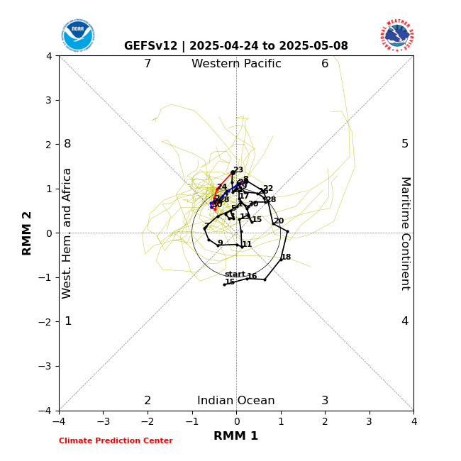
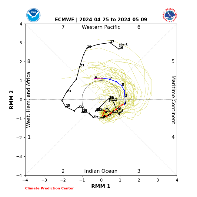
rwfromkansas wrote:orangeblood wrote:Wow, check out the MJO forecast differences b/w GFS and Euro…major implications beyond day 10
https://www.cpc.ncep.noaa.gov/products/precip/CWlink/MJO/CLIVAR/GEFS.png
https://www.cpc.ncep.noaa.gov/products/precip/CWlink/MJO/CLIVAR/ECMF.png
GFS showing potential big warmup into Phase 4 with Euro sinking into null, likely locking in cold for awhile
Come on Euro.
Euro is typically better at this range with systems like this.
0 likes
#NeverSummer
I hibernate when it gets above 75 degrees!
I hibernate when it gets above 75 degrees!

Re: Texas Winter 2022-2023
gpsnowman wrote:Hopefully this big storm will cleanse Texas of my number one enemy, mountain cedar pollen. This month has been horrible with allergies.
Couldn't agree more, been suffering it this month. Flow should be out of the north more than the south in the near future so count is kept at bay
0 likes
The above post and any post by Ntxw is NOT an official forecast and should not be used as such. It is just the opinion of the poster and may or may not be backed by sound meteorological data. It is NOT endorsed by any professional institution including Storm2k. For official information, please refer to NWS products.
Help support Storm2K!

Re: Texas Winter 2022-2023
Lagreeneyes03 wrote:TeamPlayersBlue wrote:Hopefully the Low really pulls in as much moisture as possible so our DFW folk can have some love on the backside of the low.
its too warm
The system is what will be pulling in the colder air.
4 likes
-
rwfromkansas
- Category 5

- Posts: 3010
- Joined: Sat Aug 27, 2005 12:47 am
- Location: North Fort Worth
-
bubba hotep

- S2K Supporter
- Posts: 6012
- Joined: Wed Dec 28, 2016 1:00 am
- Location: Collin County Texas
Re: Texas Winter 2022-2023
18z 3k NAM still going with a band of snow moving across the northern burbs later this afternoon.

1 likes
Winter time post are almost exclusively focused on the DFW area.
-
Iceresistance

- Category 5
- Posts: 9566
- Age: 22
- Joined: Sat Oct 10, 2020 9:45 am
- Location: Tecumseh, OK/Norman, OK
Re: Texas Winter 2022-2023
Went back up to 32°F, and it's not budging.
Everything is still snow covered, saw a report that Tecumseh got 2 inches so far.
Everything is still snow covered, saw a report that Tecumseh got 2 inches so far.
2 likes
Bill 2015 & Beta 2020
Winter 2020-2021
All observations are in Tecumseh, OK unless otherwise noted.
Winter posts are focused mainly for Oklahoma & Texas.
Take any of my forecasts with a grain of salt, refer to the NWS, SPC, and NHC for official information
Never say Never with weather! Because ANYTHING is possible!
Winter 2020-2021
All observations are in Tecumseh, OK unless otherwise noted.
Winter posts are focused mainly for Oklahoma & Texas.
Take any of my forecasts with a grain of salt, refer to the NWS, SPC, and NHC for official information
Never say Never with weather! Because ANYTHING is possible!
-
Texas Snowman

- Storm2k Moderator

- Posts: 6197
- Joined: Fri Jan 25, 2008 11:29 am
- Location: Denison, Texas
Re: Texas Winter 2022-2023
Snow mixing in with the rain here In Denison…
2 likes
The above post and any post by Texas Snowman is NOT an official forecast and should not be used as such. It is just the opinion of the poster and may or may not be backed by sound meteorological data. It is NOT endorsed by any professional institution including storm2k.org. For official information, please refer to NWS products.

-
TropicalTundra

- S2K Supporter
- Posts: 738
- Joined: Wed Oct 16, 2019 12:56 pm
- Location: Temple, Texas
Re: Texas Winter 2022-2023
Rain stopped and temp is hard stuck at 46.
Wishing y'all in Dallas some snow.
Wishing y'all in Dallas some snow.
2 likes
Snow in Texas? What’s that?
Don't use my posts as forecast; I'm not a certified meteorologist! I just endorse cold weather, alright?
All observations I note are for Temple, Texas unless otherwise stated.
-
txtwister78

- Category 5
- Posts: 2139
- Joined: Wed Jan 30, 2019 12:56 pm
- Location: San Antonio
Re: Texas Winter 2022-2023
Looks like a confirmed tornado is on the ground in eastern areas of Houston metro.
Definite debris signature being picked up on radar/CC
Definite debris signature being picked up on radar/CC
0 likes
-
rwfromkansas
- Category 5
- Posts: 3010
- Joined: Sat Aug 27, 2005 12:47 am
- Location: North Fort Worth
-
Iceresistance
- Category 5
- Posts: 9566
- Age: 22
- Joined: Sat Oct 10, 2020 9:45 am
- Location: Tecumseh, OK/Norman, OK
Re: Texas Winter 2022-2023
txtwister78 wrote:Looks like a confirmed tornado is on the ground in eastern areas of Houston metro.
Definite debris signature being picked up on radar/CC
It's PDS Warned now, oh boy
Severe Weather Statement
National Weather Service Houston/Galveston TX
221 PM CST Tue Jan 24 2023
TXC201-242030-
/O.CON.KHGX.TO.W.0007.000000T0000Z-230124T2030Z/
Harris TX-
221 PM CST Tue Jan 24 2023
...A TORNADO WARNING REMAINS IN EFFECT UNTIL 230 PM CST FOR
SOUTHEASTERN HARRIS COUNTY...
At 220 PM CST, a confirmed large and extremely dangerous tornado was
located over southeastern South Belt / Ellington, moving east at 45
mph.
This is a PARTICULARLY DANGEROUS SITUATION. TAKE COVER NOW!
HAZARD...Damaging tornado.
SOURCE...Radar confirmed tornado.
IMPACT...You are in a life-threatening situation. Flying debris may
be deadly to those caught without shelter. Mobile homes
will be destroyed. Considerable damage to homes,
businesses, and vehicles is likely and complete destruction
is possible.
The tornado will be near...
Northern Clear Lake around 230 PM CST.
Western Pasadena around 235 PM CST.
PRECAUTIONARY/PREPAREDNESS ACTIONS...
To repeat, a large, extremely dangerous and potentially deadly
tornado is on the ground. To protect your life, TAKE COVER NOW! Move
to a basement or an interior room on the lowest floor of a sturdy
building. Avoid windows. If you are outdoors, in a mobile home, or in
a vehicle, move to the closest substantial shelter and protect
yourself from flying debris.
&&
LAT...LON 2958 9522 2963 9525 2969 9511 2959 9506
TIME...MOT...LOC 2020Z 250DEG 41KT 2958 9520
TORNADO...OBSERVED
TORNADO DAMAGE THREAT...CONSIDERABLE
MAX HAIL SIZE...<.75 IN
0 likes
Bill 2015 & Beta 2020
Winter 2020-2021
All observations are in Tecumseh, OK unless otherwise noted.
Winter posts are focused mainly for Oklahoma & Texas.
Take any of my forecasts with a grain of salt, refer to the NWS, SPC, and NHC for official information
Never say Never with weather! Because ANYTHING is possible!
Winter 2020-2021
All observations are in Tecumseh, OK unless otherwise noted.
Winter posts are focused mainly for Oklahoma & Texas.
Take any of my forecasts with a grain of salt, refer to the NWS, SPC, and NHC for official information
Never say Never with weather! Because ANYTHING is possible!
-
txtwister78
- Category 5
- Posts: 2139
- Joined: Wed Jan 30, 2019 12:56 pm
- Location: San Antonio

-
Iceresistance
- Category 5
- Posts: 9566
- Age: 22
- Joined: Sat Oct 10, 2020 9:45 am
- Location: Tecumseh, OK/Norman, OK
Re: Texas Winter 2022-2023
Holy Crap . . .
Tornado Warning
TXC071-201-291-242100-
/O.NEW.KHGX.TO.W.0008.230124T2024Z-230124T2100Z/
BULLETIN - EAS ACTIVATION REQUESTED
Tornado Warning
National Weather Service Houston/Galveston TX
224 PM CST Tue Jan 24 2023
...TORNADO EMERGENCY FOR PARTS OF SOUTH HARRIS...
The National Weather Service in League City has issued a
* Tornado Warning for...
Northwestern Chambers County in southeastern Texas...
South central Liberty County in southeastern Texas...
Southeastern Harris County in southeastern Texas...
* Until 300 PM CST.
* At 223 PM CST, a confirmed large and destructive tornado was
observed over northwestern Pasadena, moving northeast at 60 mph.
TORNADO EMERGENCY for parts of SE TEXAS. This is a PARTICULARLY
DANGEROUS SITUATION. TAKE COVER NOW!
HAZARD...Deadly tornado.
SOURCE...Radar confirmed tornado.
IMPACT...You are in a life-threatening situation. Flying debris
may be deadly to those caught without shelter. Mobile
homes will be destroyed. Considerable damage to homes,
businesses, and vehicles is likely and complete
destruction is possible.
* The tornado will be near...
Morgan`s Point and San Jacinto State Park around 230 PM CST.
Baytown, Highlands and Channelview around 235 PM CST.
Barrett around 240 PM CST.
Mont Belvieu and Cove around 245 PM CST.
Old River-Winfree around 250 PM CST.
PRECAUTIONARY/PREPAREDNESS ACTIONS...
To repeat, a large, extremely dangerous and potentially deadly
tornado is on the ground. To protect your life, TAKE COVER NOW! Move
to an interior room on the lowest floor of a sturdy building. Avoid
windows. If in a mobile home, a vehicle or outdoors, move to the
closest substantial shelter and protect yourself from flying debris.
&&
LAT...LON 2960 9517 2967 9523 2998 9489 2992 9478
2982 9475
TIME...MOT...LOC 2023Z 231DEG 51KT 2967 9514
TORNADO...OBSERVED
TORNADO DAMAGE THREAT...CATASTROPHIC
MAX HAIL SIZE...<.75 IN
0 likes
Bill 2015 & Beta 2020
Winter 2020-2021
All observations are in Tecumseh, OK unless otherwise noted.
Winter posts are focused mainly for Oklahoma & Texas.
Take any of my forecasts with a grain of salt, refer to the NWS, SPC, and NHC for official information
Never say Never with weather! Because ANYTHING is possible!
Winter 2020-2021
All observations are in Tecumseh, OK unless otherwise noted.
Winter posts are focused mainly for Oklahoma & Texas.
Take any of my forecasts with a grain of salt, refer to the NWS, SPC, and NHC for official information
Never say Never with weather! Because ANYTHING is possible!
-
txtwister78
- Category 5
- Posts: 2139
- Joined: Wed Jan 30, 2019 12:56 pm
- Location: San Antonio
-
Texas Snowman
- Storm2k Moderator
- Posts: 6197
- Joined: Fri Jan 25, 2008 11:29 am
- Location: Denison, Texas
Re: Texas Winter 2022-2023
BULLETIN - EAS ACTIVATION REQUESTED
Tornado Warning
National Weather Service Houston/Galveston TX
224 PM CST Tue Jan 24 2023
...TORNADO EMERGENCY FOR PARTS OF SOUTH HARRIS...
The National Weather Service in League City has issued a
* Tornado Warning for...
Northwestern Chambers County in southeastern Texas...
South central Liberty County in southeastern Texas...
Southeastern Harris County in southeastern Texas...
* Until 300 PM CST.
* At 223 PM CST, a confirmed large and destructive tornado was
observed over northwestern Pasadena, moving northeast at 60 mph.
TORNADO EMERGENCY for parts of SE TEXAS. This is a PARTICULARLY
DANGEROUS SITUATION. TAKE COVER NOW!
HAZARD...Deadly tornado.
SOURCE...Radar confirmed tornado.
IMPACT...You are in a life-threatening situation. Flying debris
may be deadly to those caught without shelter. Mobile
homes will be destroyed. Considerable damage to homes,
businesses, and vehicles is likely and complete
destruction is possible.
* The tornado will be near...
Morgan's Point and San Jacinto State Park around 230 PM CST.
Baytown, Highlands and Channelview around 235 PM CST.
Barrett around 240 PM CST.
Mont Belvieu and Cove around 245 PM CST.
Old River-Winfree around 250 PM CST.
PRECAUTIONARY/PREPAREDNESS ACTIONS...
To repeat, a large, extremely dangerous and potentially deadly
tornado is on the ground. To protect your life, TAKE COVER NOW! Move
to an interior room on the lowest floor of a sturdy building. Avoid
windows. If in a mobile home, a vehicle or outdoors, move to the
closest substantial shelter and protect yourself from flying debris.
&&
LAT...LON 2960 9517 2967 9523 2998 9489 2992 9478
2982 9475
TIME...MOT...LOC 2023Z 231DEG 51KT 2967 9514
0 likes
The above post and any post by Texas Snowman is NOT an official forecast and should not be used as such. It is just the opinion of the poster and may or may not be backed by sound meteorological data. It is NOT endorsed by any professional institution including storm2k.org. For official information, please refer to NWS products.
-
Iceresistance
- Category 5
- Posts: 9566
- Age: 22
- Joined: Sat Oct 10, 2020 9:45 am
- Location: Tecumseh, OK/Norman, OK
Re: Texas Winter 2022-2023
Severe Weather Statement
National Weather Service Houston/Galveston TX
229 PM CST Tue Jan 24 2023
TXC071-201-291-242100-
/O.CON.KHGX.TO.W.0008.000000T0000Z-230124T2100Z/
Chambers TX-Liberty TX-Harris TX-
229 PM CST Tue Jan 24 2023
...TORNADO EMERGENCY FOR SE HARRIS...
...A TORNADO WARNING REMAINS IN EFFECT UNTIL 300 PM CST FOR
NORTHWESTERN CHAMBERS...SOUTH CENTRAL LIBERTY AND EAST CENTRAL HARRIS
COUNTIES...
At 228 PM CST, a confirmed large and destructive tornado was located
over Deer Park, moving northeast at 40 mph.
TORNADO EMERGENCY for SE HARRIS.
This is a PARTICULARLY DANGEROUS SITUATION. TAKE COVER NOW!
HAZARD...Deadly tornado.
SOURCE...Radar confirmed tornado.
IMPACT...You are in a life-threatening situation. Flying debris may
be deadly to those caught without shelter. Mobile homes
will be destroyed. Considerable damage to homes,
businesses, and vehicles is likely and complete destruction
is possible.
The tornado will be near...
Baytown and Highlands around 240 PM CST.
Barrett around 245 PM CST.
Mont Belvieu and Cove around 255 PM CST.
Old River-Winfree around 300 PM CST.
PRECAUTIONARY/PREPAREDNESS ACTIONS...
To repeat, a large, extremely dangerous, and potentially deadly
tornado is on the ground. To protect your life, TAKE COVER NOW! Move
to an interior room on the lowest floor of a sturdy building. Avoid
windows. If in a mobile home, a vehicle or outdoors, move to the
closest substantial shelter and protect yourself from flying debris.
&&
LAT...LON 2982 9475 2965 9510 2972 9518 2998 9489
2992 9478
TIME...MOT...LOC 2028Z 230DEG 36KT 2970 9511
TORNADO...OBSERVED
TORNADO DAMAGE THREAT...CATASTROPHIC
MAX HAIL SIZE...<.75 IN
0 likes
Bill 2015 & Beta 2020
Winter 2020-2021
All observations are in Tecumseh, OK unless otherwise noted.
Winter posts are focused mainly for Oklahoma & Texas.
Take any of my forecasts with a grain of salt, refer to the NWS, SPC, and NHC for official information
Never say Never with weather! Because ANYTHING is possible!
Winter 2020-2021
All observations are in Tecumseh, OK unless otherwise noted.
Winter posts are focused mainly for Oklahoma & Texas.
Take any of my forecasts with a grain of salt, refer to the NWS, SPC, and NHC for official information
Never say Never with weather! Because ANYTHING is possible!
-
Texas Snowman
- Storm2k Moderator
- Posts: 6197
- Joined: Fri Jan 25, 2008 11:29 am
- Location: Denison, Texas
Re: Texas Winter 2022-2023
Now over the Houston Ship Channel…
Severe Weather Statement
National Weather Service Houston/Galveston TX
234 PM CST Tue Jan 24 2023
TXC071-201-291-242100-
/O.CON.KHGX.TO.W.0008.000000T0000Z-230124T2100Z/
Chambers TX-Liberty TX-Harris TX-
234 PM CST Tue Jan 24 2023
...TORNADO EMERGENCY FOR SE HARRIS COUNTY AND WESTERN CHAMBERS
COUNTY...
...A TORNADO WARNING REMAINS IN EFFECT UNTIL 300 PM CST FOR
NORTHWESTERN CHAMBERS...SOUTH CENTRAL LIBERTY AND EAST CENTRAL HARRIS
COUNTIES...
At 233 PM CST, a confirmed large and destructive tornado was located
over Houston Ship Channel near Deer Park, moving northeast at 45 mph.
TORNADO EMERGENCY for SE HARRIS COUNTY AND WESTERN CHAMBERS COUNTY.
This is a PARTICULARLY DANGEROUS SITUATION. TAKE COVER NOW!
HAZARD...Deadly tornado.
SOURCE...Radar confirmed tornado.
IMPACT...You are in a life-threatening situation. Flying debris may
be deadly to those caught without shelter. Mobile homes
will be destroyed. Considerable damage to homes,
businesses, and vehicles is likely and complete destruction
is possible.
The tornado will be near...
Baytown around 240 PM CST.
Barrett around 245 PM CST.
Cove around 250 PM CST.
Mont Belvieu around 255 PM CST.
Old River-Winfree around 300 PM CST.
PRECAUTIONARY/PREPAREDNESS ACTIONS...
To repeat, a large, extremely dangerous, and potentially deadly
tornado is on the ground. To protect your life, TAKE COVER NOW! Move
to an interior room on the lowest floor of a sturdy building. Avoid
windows. If in a mobile home, a vehicle or outdoors, move to the
closest substantial shelter and protect yourself from flying debris.
0 likes
The above post and any post by Texas Snowman is NOT an official forecast and should not be used as such. It is just the opinion of the poster and may or may not be backed by sound meteorological data. It is NOT endorsed by any professional institution including storm2k.org. For official information, please refer to NWS products.
Who is online
Users browsing this forum: Brent, Hurricane2022, Stratton23, tolakram and 69 guests