Deep South Winterwx Discussion 2015-2016

Winter Weather Discussion

Moderator: S2k Moderators

Forum rules

The posts in this forum are NOT official forecast and should not be used as such. They are just the opinion of the poster and may or may not be backed by sound meteorological data. They are NOT endorsed by any professional institution or STORM2K.

Help Support Storm2K
Message
Author
User avatar
Ivanhater
Storm2k Moderator
Storm2k Moderator
Posts: 11160
Age: 38
Joined: Fri Jul 01, 2005 8:25 am
Location: Pensacola

Re: Deep South Snow/Winterwx thread (2009-2010)

#481 Postby Ivanhater » Wed Dec 02, 2009 3:36 pm

18 z NAM, 60 hours :eek: :eek: :eek:

Image

Image
0 likes   
Michael

User avatar
PTrackerLA
Category 5
Category 5
Posts: 5277
Age: 41
Joined: Thu Oct 10, 2002 8:40 pm
Location: Lafayette, LA

#482 Postby PTrackerLA » Wed Dec 02, 2009 3:41 pm

Ivan that model shows New Orleans getting crushed with snow! Unbelievable!
0 likes   

SunnyThoughts
Category 5
Category 5
Posts: 2263
Joined: Wed Jul 09, 2003 12:42 pm
Location: Pensacola, Florida

#483 Postby SunnyThoughts » Wed Dec 02, 2009 3:42 pm

yay...my hopes are still alive...I think? haha
0 likes   

User avatar
Ivanhater
Storm2k Moderator
Storm2k Moderator
Posts: 11160
Age: 38
Joined: Fri Jul 01, 2005 8:25 am
Location: Pensacola

Re:

#484 Postby Ivanhater » Wed Dec 02, 2009 3:50 pm

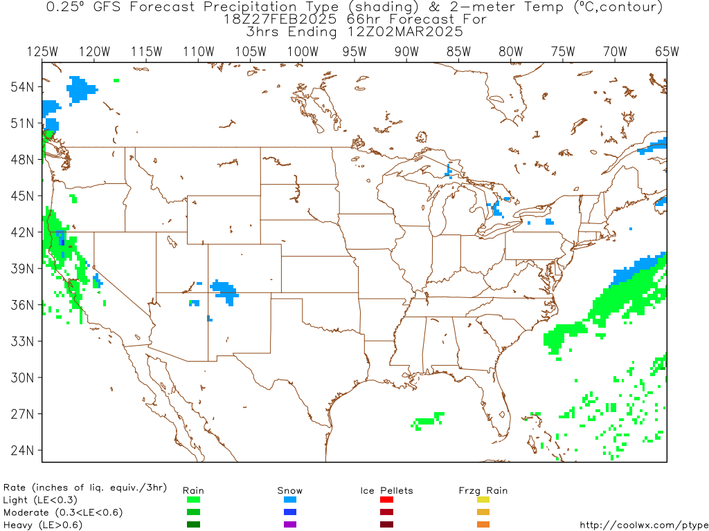
PTrackerLA wrote:Ivan that model shows New Orleans getting crushed with snow! Unbelievable!


Yep PT! And much of the Gulfcoast From Texas to the Florida Panhandle getting in on some moderate snow. You can see on the NAM that it develops a stronger Gulf low, that is the cause for the heavier precip. Gotta love these El nino winters.
0 likes   
Michael

Brent
S2K Supporter
S2K Supporter
Posts: 38087
Age: 36
Joined: Sun May 16, 2004 10:30 pm
Location: Tulsa Oklahoma
Contact:

Re: Deep South Snow/Winterwx thread (2009-2010)

#485 Postby Brent » Wed Dec 02, 2009 4:00 pm

That looks fun. :P
0 likes   
#neversummer

Brent
S2K Supporter
S2K Supporter
Posts: 38087
Age: 36
Joined: Sun May 16, 2004 10:30 pm
Location: Tulsa Oklahoma
Contact:

Re: Deep South Snow/Winterwx thread (2009-2010)

#486 Postby Brent » Wed Dec 02, 2009 4:25 pm

From Birmingham:

BY EARLY FRIDAY EVENING A NOTICEABLE SHORTWAVE SHOULD BE ROUNDING
THE BASE OF THE LONGWAVE TROUGH OVER SOUTHEASTERN TEXAS. AS IT
LIFTS NORTHEAST AND ACROSS THE AREA FRIDAY NIGHT AND SATURDAY
MORNING, SOME MOISTURE WILL GET PULLED FROM THE GULF AND BEGIN TO
OVERSPREAD CENTRAL ALABAMA. THIS IS A BIT DIFFERENT FROM THE 12Z
MODEL RUNS FROM YESTERDAY IN WHICH THE CONSENSUS SHOWED DRIER AND
COOLER CONDITIONS ACROSS THE AREA. THERMAL PROFILES SHOW A WINDOW
FOR SOME LIGHT SNOW TO DEVELOP ON THE NORTH SIDE OF THE
PRECIPITATION SHIELD FROM ROUGHLY 09Z SATURDAY AND POTENTIALLY
LASTING THROUGH 18Z. SO AT THIS POINT I WOULD EXPECT THE NORTHERN
HALF OF THE AREA TO SEE SOME LIGHT SNOWFALL SATURDAY MORNING WITH
A COLD RAIN TO THE SOUTH. SOME VERY LIGHT ACCUMULATIONS MAY BE
POSSIBLE ON ELEVATED SURFACES. NO WEATHER RELATED TRAVEL PROBLEMS
ARE ANTICIPATED.


Friday Night...Cloudy. Chance of snow or slight chance of rain after midnight. Lows in the mid 30s. North winds 5 to 10 mph. Chance of precipitation 50 percent.

Saturday...Cloudy with a 50 percent chance of snow in the morning...then partly cloudy in the afternoon. Highs in the lower 40s.
0 likes   
#neversummer

Stormcenter
S2K Supporter
S2K Supporter
Posts: 6683
Joined: Wed Sep 03, 2003 11:27 am
Location: Houston, TX

#487 Postby Stormcenter » Wed Dec 02, 2009 5:09 pm

This may be legit after all for the deep south.

AREA FORECAST DISCUSSION
NATIONAL WEATHER SERVICE NEW ORLEANS LA
359 PM CST WED DEC 2 2009

.SHORT TERM...

A VERY UNUSUAL SNOW EVENT LOOKS TO DEVELOP OVER PORTIONS OF THE
FORECAST AREA WITHIN THE NEXT 72 HOURS. FOR THIS EVENT TO
DEVELOP...SEVERAL FACTORS MUST COME TOGETHER AT THE RIGHT TIME.
CURRENTLY...FORECAST GUIDANCE HAS A FAIRLY GOOD HANDLE ON THE
MID-UPPER LEVEL DYNAMICS OF THIS SYSTEM...AND ARE IN VERY GOOD
AGREEMENT ON THE TIMING AND STRENGTH OF THE UPPER LEVEL TROUGH. IN
FACT...IT APPEARS THAT SOME VERY VIGOROUS UPPER LEVEL LIFT WILL BE
TAKING PLACE ACROSS THE REGION LATE FRIDAY INTO EARLY SATURDAY.
THIS WILL PLAY A ROLE IN THE SNOWFALL EXPECTED OVER THE NORTHERN
THIRD OF THE CWA. THE DIFFERENCES ARISE IN THE LOW LEVEL
DEVELOPMENT OF THE LOW PRESSURE SYSTEM...AND THE TIMING OF THE DRY AIR
INTRUSION AT AROUND 850MB LATE FRIDAY NIGHT INTO EARLY SATURDAY
MORNING. ALL OF THE MODELS DEPICT A STRONG GULF LOW DEVELOPING
OVER THE WESTERN GULF OF MEXICO ON FRIDAY...AS A POSITIVELY TILTED
UPPER LEVEL TROUGH AXIS DIVES SOUTHWARD THROUGH THE SOUTHERN
PLAINS. THIS LOW WILL FORM IN A REGION OF ENHANCED BAROCLINICITY
CENTERED AROUND A STALLED FRONTAL BOUNDARY. THE LOW WILL CONTINUE
TO DEEPEN IN RESPONSE TO A JET COUPLET THAT IS EXPECTED TO DEVELOP
OVER THE WESTERN GULF FRIDAY AFTERNOON. BY FRIDAY EVENING...THE
LOW WILL BE OVER THE CENTRAL GULF OF MEXICO. STRONG MOISTURE
ADVECTION IN THE MID-LEVELS WILL TAKE PLACE FRIDAY EVENING ACROSS
THE REGION AS THE LOW MOVES THROUGH THE GULF. THIS MID-LEVEL
MOISTURE...COMBINED WITH SOME UPPER LEVEL MOISTURE MOVING IN WITH
THE UPPER LEVEL TROUGH AXIS WILL BE THE FUEL THAT FEEDS THE
PRECIPITATION EVENT FRIDAY NIGHT. AS STATED BEFORE...THE MODELS
ARE IN GOOD AGREEMENT ON THIS SITUATION.

AT THE SAME TIME THAT THE MOISTURE BEGINS TO FEED INTO THE
REGION...COLDER AIR WILL BE DRAWN SOUTHWARD IN RESPONSE TO THE
STRENGTHENING SURFACE LOW IN THE GULF. TEMPERATURES WILL BEGIN TO
FALL ACROSS THE CWA FRIDAY AFTERNOON AS THIS COLDER AIR MOVES IN.
THE MOST NOTICABLE TEMPERATURE CHANGES WILL BE FROM 800MB DOWN TO
THE SURFACE. MODEL SOUNDINGS SHOW A GOOD 5 DEGREE DROP IN
TEMPERATURES FROM 18Z FRIDAY TO 06Z SATURDAY. THIS DROP PLACES THE
LOWER ATMOSPHERE INTO A MORE FAVORABLE ZONE FOR SNOW DEVELOPMENT
FOR AREAS ACROSS SOUTHWEST MISSISSIPPI AND PARTS OF SOUTHEAST
LOUISIANA NORTH OF I-12. AS A RESULT...EXPECT SNOW TO DEVELOP
SOMETIME IN THE LATE EVENING HOURS FRIDAY AND LINGER THROUGH THE
NIGHT. ACCUMULATIONS ARE HARD TO PINPOINT AT THIS TIME...BUT SOME
ACCUMULATION WILL BE POSSIBLE.

THE MAIN DIFFERENCES ARISE IN THE EXACT DURATION OF THE SNOWFALL.
THE GFS AND ECMWF BOTH DEPICT STRONG DRY AIR ADVECTION TAKING HOLD
BY 12Z...WITH THE STRONGEST DRYING IN THE MID-LEVELS.
HOWEVER...THE NAM CONTINUES TO HOLD MID-LEVEL MOISTURE IN THE
REGION FOR A FEW MORE HOURS...BEFORE SHOWING STRONG DRYING AROUND
18Z. AT THIS TIME...HAVE LEANED MORE TOWARD THE GFS AND
ECMWF...WITH DRYING TAKING PLACE EARLY SATURDAY MORNING
0 likes   

User avatar
Ivanhater
Storm2k Moderator
Storm2k Moderator
Posts: 11160
Age: 38
Joined: Fri Jul 01, 2005 8:25 am
Location: Pensacola

Re: Deep South Snow/Winterwx thread (2009-2010)

#488 Postby Ivanhater » Wed Dec 02, 2009 5:14 pm

Heavy Snow :double:

Image
0 likes   
Michael

attallaman

Re: Deep South Snow/Winterwx thread (2009-2010)

#489 Postby attallaman » Wed Dec 02, 2009 7:10 pm

CYCLONE MIKE wrote:If anyone cares to elaborate feel free. I have a feeling this could be more and more like the event we experienced last year down here. A day or two before it happened the nws and local mets finally starting saying mix, then light accum, then an inch, and so on. We ended up with three inches on the ground at my house.
As of this morning word is we could see an inch friday night saturday morning. Cold air seems not to be the issue its how much moisture. They are waiting on more model runs to see if another low will in fact form in the gulf and where it moves and of course how strong. IF it does and stays further south than the one yesterday we could easily see more snow than forecast. Just in wait and see what happens mode. Going to be interesting to say the least.
Get your cameras ready. I was about to say stock up on film but I had to remind myself that we're in the digital age now although I still have an excellent Minolta Freedom Zoom 90 35mm camera that made it through Katrina and still takes excellent pictures along with a Panasonic DMC-FZ20 digicamera.
0 likes   

User avatar
Ivanhater
Storm2k Moderator
Storm2k Moderator
Posts: 11160
Age: 38
Joined: Fri Jul 01, 2005 8:25 am
Location: Pensacola

Re: Deep South Snow/Winterwx thread (2009-2010)

#490 Postby Ivanhater » Wed Dec 02, 2009 7:28 pm

18z GFS

Image
0 likes   
Michael

SunnyThoughts
Category 5
Category 5
Posts: 2263
Joined: Wed Jul 09, 2003 12:42 pm
Location: Pensacola, Florida

#491 Postby SunnyThoughts » Wed Dec 02, 2009 7:34 pm

Oh so closeeeeee :(
0 likes   

attallaman

Re: Deep South Snow/Winterwx thread (2009-2010)

#492 Postby attallaman » Wed Dec 02, 2009 7:38 pm

Ivanhater wrote:18z GFS

Image
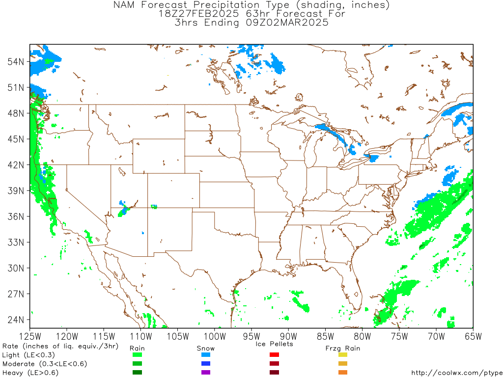
If I'm reading that map right it looks like rain for my area, no snow? Shucks.
0 likes   

User avatar
Ivanhater
Storm2k Moderator
Storm2k Moderator
Posts: 11160
Age: 38
Joined: Fri Jul 01, 2005 8:25 am
Location: Pensacola

Re: Deep South Snow/Winterwx thread (2009-2010)

#493 Postby Ivanhater » Wed Dec 02, 2009 7:43 pm

Take these maps with a grain of salt, With these types of setups, we will probably not know where the snow line will be until it is already here. The NAM is showing heavy snow for the MGC. With the trends in the models, snow is becoming more likely for the Gulfcoast :P
0 likes   
Michael

Jag95
Category 1
Category 1
Posts: 438
Joined: Sat Aug 15, 2009 8:43 pm
Location: Mobile, AL

#494 Postby Jag95 » Wed Dec 02, 2009 8:30 pm

After my last road bust, it's going to have to come to me this time, especially with the SEC CG at 4. It will be a close call for us on the coast, as normal. We probably have a better than average chance this year though, with the Climate Prediction Center predicting below normal temps for the next 3 months. Just have to keep that moisture train going.
0 likes   

User avatar
MGC
S2K Supporter
S2K Supporter
Posts: 5897
Joined: Sun Mar 23, 2003 9:05 pm
Location: Pass Christian MS, or what is left.

Re: Deep South Snow/Winterwx thread (2009-2010)

#495 Postby MGC » Wed Dec 02, 2009 8:49 pm

Yea, I would freak out if that NAM verifies. Still not convinced it will snow. Seems every time snow is forecast it don't happen.....MGC
0 likes   

User avatar
Ivanhater
Storm2k Moderator
Storm2k Moderator
Posts: 11160
Age: 38
Joined: Fri Jul 01, 2005 8:25 am
Location: Pensacola

Re: Deep South Snow/Winterwx thread (2009-2010)

#496 Postby Ivanhater » Wed Dec 02, 2009 8:58 pm

MGC wrote:Yea, I would freak out if that NAM verifies. Still not convinced it will snow. Seems every time snow is forecast it don't happen.....MGC


Unfortunately MGC, our area finds itself easy to get hurricanes, but hard to get snow. Part of living on the Gulfcoast.
0 likes   
Michael

attallaman

Re: Deep South Snow/Winterwx thread (2009-2010)

#497 Postby attallaman » Wed Dec 02, 2009 9:25 pm

Was it last year that it snowed in NOLA?
0 likes   

attallaman

Re: Deep South Snow/Winterwx thread (2009-2010)

#498 Postby attallaman » Wed Dec 02, 2009 9:28 pm

MGC wrote:Yea, I would freak out if that NAM verifies. Still not convinced it will snow. Seems every time snow is forecast it don't happen.....MGC
MGC, you got your digicam all charged up with a new memory card and ready to go?
0 likes   

User avatar
Ivanhater
Storm2k Moderator
Storm2k Moderator
Posts: 11160
Age: 38
Joined: Fri Jul 01, 2005 8:25 am
Location: Pensacola

Re: Deep South Snow/Winterwx thread (2009-2010)

#499 Postby Ivanhater » Wed Dec 02, 2009 9:34 pm

00z Nam...Get your Camera's ready all along the Gulfcoast! :D :D

Image

Image
0 likes   
Michael

attallaman

Re: Deep South Snow/Winterwx thread (2009-2010)

#500 Postby attallaman » Wed Dec 02, 2009 9:55 pm

Ivanhater wrote:00z Nam...Get your Camera's ready all along the Gulfcoast! :D :D

Image

Image
Charging my batteries as we speak.
0 likes   


Return to “Winter Weather”

Who is online

Users browsing this forum: Google Adsense [Bot], Quixotic and 6 guests