Southern Plains winter wx thread (2009-2010)

Winter Weather Discussion

Moderator: S2k Moderators

Forum rules

The posts in this forum are NOT official forecast and should not be used as such. They are just the opinion of the poster and may or may not be backed by sound meteorological data. They are NOT endorsed by any professional institution or STORM2K.

Help Support Storm2K
Message
Author
User avatar
Extremeweatherguy
Category 5
Category 5
Posts: 11095
Joined: Mon Oct 10, 2005 8:13 pm
Location: Florida

Re: Southern Plains winter wx thread (2009-2010)

#521 Postby Extremeweatherguy » Mon Feb 01, 2010 1:18 am

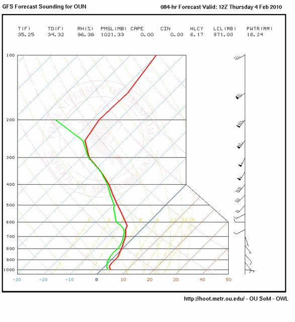
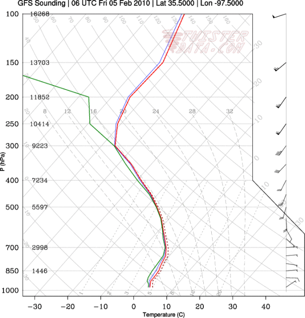
It is going to be very borderline with this midweek event. As of now it seems most likely to be rain, but based on the 00z GFS skew-t output, it could also conceivably mix with or even turn over to snow at some point. Its going to be a very close call! If the GFS output is right on or too cold then it will be rain, but if the GFS output is just a few degrees too warm then it could easily be snow. This will be something to watch closely IMO.

00z GFS skew-t output for the Norman, OK site (OUN) valid 12z Thursday morning:
Image
0 likes   

User avatar
wall_cloud
Professional-Met
Professional-Met
Posts: 401
Age: 48
Joined: Sun Dec 04, 2005 7:32 am
Location: Bartlett, TN
Contact:

Re: Southern Plains winter wx thread (2009-2010)

#522 Postby wall_cloud » Mon Feb 01, 2010 2:44 am

vbhoutex wrote:Wow!! I echo Steve's comment. Even though I knew there were road closures during the storm and that some areas had gotten up to a foot of snow, I didn't know it was like that!! Thanks for posting the pics.

now you understand my disdain for winter weather LOL. Its all good...it comes with the territory and keeps my job interesting. Its a blast to forecast but a nightmare to travel in and/or dig out.
0 likes   
My comments are my own and do not reflect those of NOAA or the National Weather Service.

Weatherdude20

Re: Southern Plains winter wx thread (2009-2010)

#523 Postby Weatherdude20 » Mon Feb 01, 2010 9:14 am

28, and Freezing fog here. Visibility around 3 miles. Its odd how you can see the ice crystals in the fog...
0 likes   

User avatar
Extremeweatherguy
Category 5
Category 5
Posts: 11095
Joined: Mon Oct 10, 2005 8:13 pm
Location: Florida

Re: Southern Plains winter wx thread (2009-2010)

#524 Postby Extremeweatherguy » Mon Feb 01, 2010 5:09 pm

The latest model skew-t guidance for the mid/late week event continues to look very borderline for OKC. It seems as though there will be periods where we are literally straddling the line between rain, snow and a mix. For now the NWS has left the precipitation type as only rain, and that is probably a good move, but I wouldn't be surprised at all to see their forecast change rapidly in the days ahead..especially if the models trend colder.

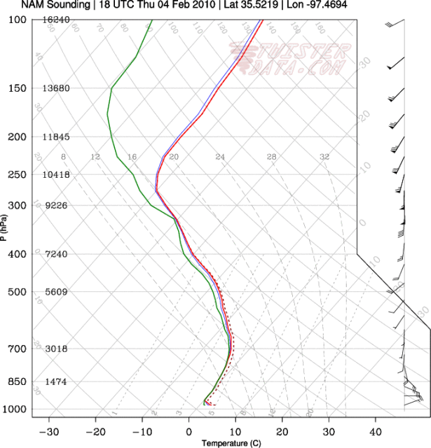
Here is a look at some of the "borderline" 18z skew-t guidance. Very much on the edge between rain and snow...

18z NAM valid 18z Thursday for OKC:
Image


18z GFS valid 06z Friday for OKC:
Image
0 likes   

User avatar
srainhoutx
S2K Supporter
S2K Supporter
Posts: 6919
Age: 67
Joined: Sun Jan 14, 2007 11:34 am
Location: Haywood County, NC
Contact:

Re: Southern Plains winter wx thread (2009-2010)

#525 Postby srainhoutx » Mon Feb 01, 2010 5:36 pm

EWG, the first Pacific RECON data ingest will be in the 00Z runs tonight. Hopefully things will become a bit more clear with that data.
0 likes   
Carla/Alicia/Jerry(In The Eye)/Michelle/Charley/Ivan/Dennis/Katrina/Rita/Wilma/Ike/Harvey

Member: National Weather Association
Wx Infinity Forums
http://wxinfinity.com/index.php

Facebook.com/WeatherInfinity
Twitter @WeatherInfinity

User avatar
Extremeweatherguy
Category 5
Category 5
Posts: 11095
Joined: Mon Oct 10, 2005 8:13 pm
Location: Florida

Re: Southern Plains winter wx thread (2009-2010)

#526 Postby Extremeweatherguy » Mon Feb 01, 2010 11:34 pm

The 00z NAM and GFS have trended closer to just a cold rain with the midweek system, and that is what I am inclined to believe will happen at the moment, but based on surface temperature output it could be a close call. I still wouldn't be surprised to see a little mixing during the colder periods (when surface temperatures are below 37F), but overall I think the winter weather threat level with this storm is low.

What has me much more interested is the system that could arrive this upcoming Sunday into Monday. The GFS is showing much more cold air in place as that storm rolls through, and if things play out right, we could be looking at yet another significant winter storm across the southern plains (including deep into Texas)...

GFS 850mb maps
132hrs: http://www.nco.ncep.noaa.gov/pmb/nwprod ... p_132l.gif
138hrs: http://www.nco.ncep.noaa.gov/pmb/nwprod ... p_138l.gif
144hrs: http://www.nco.ncep.noaa.gov/pmb/nwprod ... p_144l.gif
150hrs: http://www.nco.ncep.noaa.gov/pmb/nwprod ... p_150l.gif
156hrs: http://www.nco.ncep.noaa.gov/pmb/nwprod ... p_156l.gif
162hrs: http://www.nco.ncep.noaa.gov/pmb/nwprod ... p_162l.gif
168hrs: http://www.nco.ncep.noaa.gov/pmb/nwprod ... p_168l.gif
174hrs: http://www.nco.ncep.noaa.gov/pmb/nwprod ... p_174l.gif

GFS Surface maps
132hrs: http://www.nco.ncep.noaa.gov/pmb/nwprod ... n_132l.gif
138hrs: http://www.nco.ncep.noaa.gov/pmb/nwprod ... n_138l.gif
144hrs: http://www.nco.ncep.noaa.gov/pmb/nwprod ... n_144l.gif
150hrs: http://www.nco.ncep.noaa.gov/pmb/nwprod ... n_150l.gif
156hrs: http://www.nco.ncep.noaa.gov/pmb/nwprod ... n_156l.gif
162hrs: http://www.nco.ncep.noaa.gov/pmb/nwprod ... n_162l.gif
168hrs: http://www.nco.ncep.noaa.gov/pmb/nwprod ... n_168l.gif
174hrs: http://www.nco.ncep.noaa.gov/pmb/nwprod ... n_174l.gif
0 likes   

User avatar
Extremeweatherguy
Category 5
Category 5
Posts: 11095
Joined: Mon Oct 10, 2005 8:13 pm
Location: Florida

#527 Postby Extremeweatherguy » Tue Feb 02, 2010 9:50 am

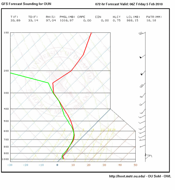
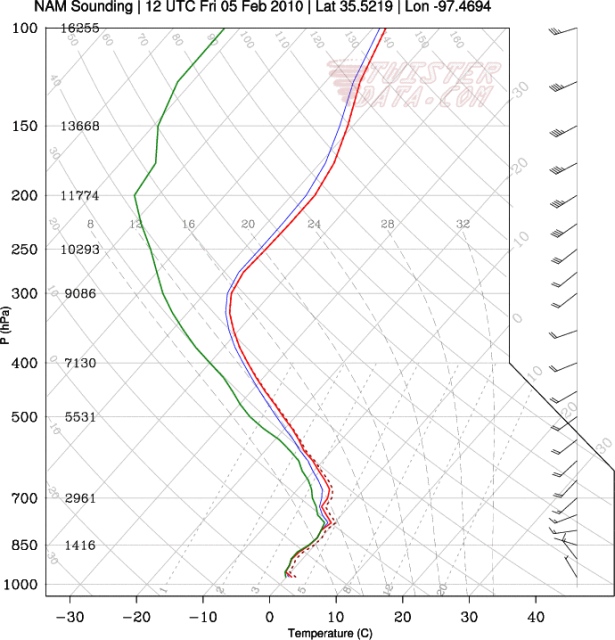
Latest models now once again look to have trended back a little colder with the mid/late week event. Last night the skew-t data indicated cold rain being most likely, but this morning it once again looks very borderline at times.

6z GFS sounding for OUN valid 6z Friday:
Image

12z NAM sounding for OKC valid 12z Friday:
Image

Overall though, I still feel the winter weather disruption threat from this system is low. Might get some mixing or a changeover, might not. Either way it probably won't be too big a deal. The Sunday/Monday/Tuesday storm is the one to watch more closely IMO.
0 likes   

User avatar
Extremeweatherguy
Category 5
Category 5
Posts: 11095
Joined: Mon Oct 10, 2005 8:13 pm
Location: Florida

#528 Postby Extremeweatherguy » Tue Feb 02, 2010 1:35 pm

The 12z GFS is showing 0.8" of new snow accumulation Thursday into Friday for OKC. So hmm, may be this storm will be a little more interesting than first thought. The GFS MOS is also getting colder with each run, showing Thursday only reaching 37F with an 89% chance of precipitation. If this trend continues, then I might have to take back my earlier comment about this event not being all that significant.
0 likes   

BlueIce
S2K Supporter
S2K Supporter
Posts: 194
Age: 37
Joined: Mon Sep 01, 2008 10:05 pm
Location: Oklahoma City, Oklahoma

Re:

#529 Postby BlueIce » Tue Feb 02, 2010 4:52 pm

Extremeweatherguy wrote:The 12z GFS is showing 0.8" of new snow accumulation Thursday into Friday for OKC. So hmm, may be this storm will be a little more interesting than first thought. The GFS MOS is also getting colder with each run, showing Thursday only reaching 37F with an 89% chance of precipitation. If this trend continues, then I might have to take back my earlier comment about this event not being all that significant.


I just saw Mike Armstrong from KWTV post up on his Facebook about the potential for snow over the weekend. Sounds like we may be ready to have round three for Oklahoma City, as of now we are over 19 Inches of snow this season in the metro.
0 likes   

User avatar
Ntxw
Storm2k Moderator
Storm2k Moderator
Posts: 22783
Joined: Wed Oct 21, 2009 6:34 pm
Location: DFW, Texas

#530 Postby Ntxw » Tue Feb 02, 2010 9:45 pm

NWS OKC thinks there will be on and off periods of rain and\or snow. Doesn't look too significant but bears watching.

Thursday: Rain likely, possibly mixed with snow. Cloudy, with a high near 39. East wind between 9 and 13 mph. Chance of precipitation is 70%.

Thursday Night: A chance of rain before midnight, then a chance of rain and snow. Cloudy, with a low around 32. North northwest wind between 5 and 9 mph. Chance of precipitation is 50%.

Friday: A slight chance of rain and snow before 11am, then a slight chance of rain. Mostly cloudy, with a high near 47. Chance of precipitation is 20%.
0 likes   
The above post and any post by Ntxw is NOT an official forecast and should not be used as such. It is just the opinion of the poster and may or may not be backed by sound meteorological data. It is NOT endorsed by any professional institution including Storm2k. For official information, please refer to NWS products.

  Help support Storm2K!
Help Support Storm2K

BlueIce
S2K Supporter
S2K Supporter
Posts: 194
Age: 37
Joined: Mon Sep 01, 2008 10:05 pm
Location: Oklahoma City, Oklahoma

Re: Southern Plains winter wx thread (2009-2010)

#531 Postby BlueIce » Tue Feb 02, 2010 9:51 pm

I am thinking that the next system for Sunday or Monday may be better as far as snow for the Oklahoma City area. Even though precip totals are not looking that impressive at this time IMO.
0 likes   

User avatar
Extremeweatherguy
Category 5
Category 5
Posts: 11095
Joined: Mon Oct 10, 2005 8:13 pm
Location: Florida

#532 Postby Extremeweatherguy » Tue Feb 02, 2010 10:49 pm

The 00z NAM is looking more like just a cold rain for OKC on Thurs/Fri. The 00z GFS, on the other hand, continues to advertise a mixing with or changeover to snow. This is looking more and more like an event that will remain a mystery up until the very end. I wouldn't be at all surprised to see just rain from this, but I also wouldn't be surprised to see mostly snow. It could easily go either way. We probably will not know for sure until the precipitation is actually falling. For now I think the NWS forecast of mostly rain, with the chance of some snow mixing in, looks pretty good.

00z NAM for Thursday at noon: http://i43.photobucket.com/albums/e371/ ... N_9750.png

00z GFS for Thursday at noon: http://i43.photobucket.com/albums/e371/ ... 975000.png

After this minor mid/late event, the GFS continues to look quite impressive for the Sunday into Monday period, showing a much better chance for winter precipitation across the southern plains. If this run of the GFS is correct, then OKC may be in for another round of accumulating snows followed by some very cold air (even colder than what we just experienced). We will have to watch this closely.

00z GFS snow accumulation map for next Monday at noon: http://i43.photobucket.com/albums/e371/ ... SURFAC.png
0 likes   

User avatar
wx247
S2K Supporter
S2K Supporter
Posts: 14279
Age: 41
Joined: Wed Feb 05, 2003 10:35 pm
Location: Monett, Missouri
Contact:

#533 Postby wx247 » Wed Feb 03, 2010 10:17 pm

NAM is still colder even tonight. Plus, could we have a Superbowl storm on the horizon for the Southern Plains? Models seem to think so...
0 likes   
Personal Forecast Disclaimer:
The posts in this forum are NOT official forecast and should not be used as such. They are just the opinion of the poster and may or may not be backed by sound meteorological data. They are NOT endorsed by any professional institution or storm2k.org. For official information, please refer to the NHC and NWS products.

BlueIce
S2K Supporter
S2K Supporter
Posts: 194
Age: 37
Joined: Mon Sep 01, 2008 10:05 pm
Location: Oklahoma City, Oklahoma

Re: Southern Plains winter wx thread (2009-2010)

#534 Postby BlueIce » Thu Feb 04, 2010 12:57 pm

Has anyone checked out the new model runs for the weekend storm? I haven't had a chance to check them out today.
0 likes   

User avatar
Extremeweatherguy
Category 5
Category 5
Posts: 11095
Joined: Mon Oct 10, 2005 8:13 pm
Location: Florida

#535 Postby Extremeweatherguy » Thu Feb 04, 2010 1:20 pm

Well the upper level air column never got moist enough this morning/this afternoon to produce large enough dendrites to make a run for reaching ground level around OKC. Instead we have been stuck with shallower moisture overhead and just a cold drizzle today with temperatures holding in the mid 30s.

Beyond today's non-event, it looks like our next chance of winter precipitation in and around OKC will arrive during the Sunday-Tuesday timeframe and then again around Thursday. As of now the potential Thursday event looks the most impressive, with the Sunday-Tuesday setup being only marginal, but things can (and likely will) change some in the days ahead.

5:55PM UPDATE: As suspected, the model changes are already happening. lol. The 18z run of the GFS now erases the big system on Thursday (except for well south into central Texas), and once again looks pretty decent for Monday, dropping 1-3 inches of windblown powder on OKC.
0 likes   

User avatar
Extremeweatherguy
Category 5
Category 5
Posts: 11095
Joined: Mon Oct 10, 2005 8:13 pm
Location: Florida

#536 Postby Extremeweatherguy » Fri Feb 05, 2010 12:10 am

The 00z GFS is looking a little more impressive with the storm early next week compared to the earlier 12z run. It is advertising a very rapid cooling of the atmospheric column during the day on Monday, and if there is still enough moisture to work with once this happens, then parts of Oklahoma (including OKC) could conceivably receive several inches of windblown snow on the backside of the storm system. For now it looks like most of the moisture might be moving out just as the atmosphere cools enough, (meaning only light amounts of snow at best), but if this gradual model trend toward a wetter/colder solution continues, then the potential of us seeing another significant winter storm will grow. Hopefully the next couple days worth of model runs will help clear things up.

BTW - It is worth noting that the GFS MOS guidance is coming in even colder than the operational output. The operational 00z run doesn't show OKC falling to below freezing until 3-4pm Monday afternoon. The 00z GFS MOS, on the other hand, drops OKC below freezing during the morning hours on Monday with temperatures then holding steady or falling for the entire afternoon. The MOS is also showing a 72% chance of precipitation across the area during the day, which means accumulating snows would be pretty likely.
0 likes   

User avatar
Extremeweatherguy
Category 5
Category 5
Posts: 11095
Joined: Mon Oct 10, 2005 8:13 pm
Location: Florida

#537 Postby Extremeweatherguy » Fri Feb 05, 2010 11:11 am

:uarrow: The 12z GFS continues the trend of colder/wetter, showing a quicker rain/snow transition on Monday across OKC. :uarrow:
0 likes   

User avatar
Extremeweatherguy
Category 5
Category 5
Posts: 11095
Joined: Mon Oct 10, 2005 8:13 pm
Location: Florida

#538 Postby Extremeweatherguy » Fri Feb 05, 2010 1:56 pm

Image
0 likes   

msstateguy83

#539 Postby msstateguy83 » Fri Feb 05, 2010 2:37 pm

Image


this is my latest map for late sunday into monday... current thinking is strong arctic front MAY arrive much earlyer then models
are currently showing therefore have raised snowfall accumulations for the entire region for sunday into monday evening.. most likely
area for heavy snow will be along and nw of interstate 44 from wichita falls to okc to tulsa... HOWEVER this could be changed in
time depending on the track of the system. I said earlyer that i thought the likelyhood of dfw getting anything major was slim to
none i still think that BUT if this comes in quicker it will give the nw area of the metroplex a slight chance of some winter precip.
the amounts on this map MAY have to be raised even higher in later forecast... stay tuned...

EDIT: totally agree w/oun this is a VERY strong arctic front temps behind the front will drop RAPIDLY so there should be a quick change over from rain/to snow
*WHICH COULD LEAD TO VERY HIGH SNOW TOTAL ACCUMULATIONS* i dont wanna go all out and get everyone overly excited just yet BUT this could be a pretty
major snowstorm for oklahoma if everything comes together right.. rightnow i would say from tulsa to okc to lawton to wichita falls points nw from there could see
VERY heavy snow.. my map may actually be abit conservative as far as amounts... i will post more thoughts on this later this evening

The following post is NOT an official forecast and should not be used as such. It is just the opinion of the poster and may or may not be backed by sound meteorological data. It is NOT endorsed by any professional institution including storm2k.org. For official information, please refer to NWS products.
0 likes   

User avatar
wx247
S2K Supporter
S2K Supporter
Posts: 14279
Age: 41
Joined: Wed Feb 05, 2003 10:35 pm
Location: Monett, Missouri
Contact:

#540 Postby wx247 » Fri Feb 05, 2010 5:15 pm

MSStateguy... curious as to your orientation of the snowbands fairly north to south as opposed to more SW to NE... any particular reasoning behind that?
0 likes   
Personal Forecast Disclaimer:
The posts in this forum are NOT official forecast and should not be used as such. They are just the opinion of the poster and may or may not be backed by sound meteorological data. They are NOT endorsed by any professional institution or storm2k.org. For official information, please refer to the NHC and NWS products.


Return to “Winter Weather”

Who is online

Users browsing this forum: No registered users and 12 guests