Texas Winter 2018-2019
Moderator: S2k Moderators
Forum rules
 The posts in this forum are NOT official forecast and should not be used as such. They are just the opinion of the poster and may or may not be backed by sound meteorological data. They are NOT endorsed by any professional institution or STORM2K.

The posts in this forum are NOT official forecast and should not be used as such. They are just the opinion of the poster and may or may not be backed by sound meteorological data. They are NOT endorsed by any professional institution or STORM2K.
-
cheezyWXguy

- Category 5

- Posts: 6280
- Joined: Mon Feb 13, 2006 12:29 am
- Location: Dallas, TX
Re: Texas Winter 2018-2019
cheezyWXguy wrote:18z NAM is dryer for DFW, no precip at all.
I might be reading it wrong but it looks to me like it’s showing 2-4” across tarrant county with temps around 30-31 tomorrow night.
0 likes
-
Texas Snow

- S2K Supporter

- Posts: 817
- Joined: Mon Oct 19, 2015 12:06 pm
- Location: N. Dallas & Cedar Creek Lake
Re: Texas Winter 2018-2019
The 18Z NAM actually expands the snow coverage area slightly over the 12Z. At least on the 12K, to clarify. Where are you looking, the 3K perhaps?
Last edited by Texas Snow on Thu Feb 07, 2019 3:53 pm, edited 1 time in total.
3 likes
"Don't let wishcastin get in the way of your forecastin"

-
Tireman4

- S2K Supporter
- Posts: 5903
- Age: 60
- Joined: Fri Jun 30, 2006 1:08 pm
- Location: Humble, Texas
- Contact:
Re: Texas Winter 2018-2019
1900hurricane wrote:Today, I realized I left my jacket in Houston...
Ooops...Facepalm...
0 likes


Re: Texas Winter 2018-2019
With the streaming STJ the surface cold is probably going to hold in place for a few days. It will be stubborn to kick out. Still seeing some big HPs up in Canada. The -PNA pattern highlights the two risks well that we have seen a big swing in temperature departures. Warm risk ahead of trough but eventually lets loose the cold air in a more favorable position.
5 likes
The above post and any post by Ntxw is NOT an official forecast and should not be used as such. It is just the opinion of the poster and may or may not be backed by sound meteorological data. It is NOT endorsed by any professional institution including Storm2k. For official information, please refer to NWS products.
Help support Storm2K!
-
Brent
- S2K Supporter
- Posts: 38715
- Age: 37
- Joined: Sun May 16, 2004 10:30 pm
- Location: Tulsa Oklahoma
- Contact:
Re: Texas Winter 2018-2019
12km NAM DFW bullseye

3km NAM the snowless streak lives on!

3km NAM the snowless streak lives on!
3 likes
#neversummer
-
Haris

- Category 5
- Posts: 1814
- Joined: Mon Nov 27, 2017 8:19 pm
- Location: ( Bee Cave) West Austin, Texas
Re: Texas Winter 2018-2019

1 likes
Weather geek and a storm spotter in West Austin. Not a degreed meteorologist. Big snow fan. Love rain and cold! Despise heat!
-
weatherdude1108
- Category 5
- Posts: 4228
- Joined: Tue Dec 13, 2011 1:04 pm
- Location: Northwest Austin/Cedar Park, TX
Re: Texas Winter 2018-2019
Too bad it hasn't been colder. Ground temps too warm to stick. We're all wishing for an "ice" day (Inclement Weather Day technically) here at work, especially on a Friday.
1 likes
The preceding post is NOT an official forecast, and should not be used as such. It is only the opinion of the poster and may or may not be backed by sound meteorological data. It is NOT endorsed by any professional institution including storm2k.org. For Official Information please refer to the NHC and NWS products.
-
Ralph's Weather
- S2K Supporter
- Posts: 3371
- Age: 38
- Joined: Fri Dec 13, 2013 11:55 am
- Location: Lindale, TX
- Contact:
Re: Texas Winter 2018-2019
wxman57 wrote:Ralph's Weather wrote: I do not know that that is totally correct. The front is not much ahead of schedule. The cold air behind it is more aggressive than the models have shown though. It remains to be seen if this is just a faster push of the coldest air if the air mass truly is colder. I lean a bit towards the former. Tomorrow's temps are highly dependent on cloud cover, morning sun equals highs near 40 if the clouds move in mid morning and stay thick ten mid 30s at best. Plenty cold enough for snow with mid 30s. The heavier the precip is the moreteps will fall with large DP depressions and cold air aloft.
Looking back at yesterday's 12z GFS run, it had the front reaching the D-FW area around 10am today. Looks like it was through by 7am, about 3 hours earlier. It is moving a bit faster 2-4 hrs and it's also possible that the GFS is too warm with the post-frontal air. Would not be the first time that the GFS is too warm.
looking upstream temps are also much colder than modeled. In Kansas temps this afternoon are buting 5-10 degrees cold. That air is still filtering south. Temps will not be the reason we do not see wintery precip tomorrow. And I love seeing the tail of this front tapping into the low over Hawaii. This pattern looks to be on repeat through Feb with moisture becoming more abundant as time goes on.
2 likes
Follow on Facebook at Ralph's Weather.
-
stormlover2013
Re: Texas Winter 2018-2019
0 likes
-
weatherdude1108
- Category 5
- Posts: 4228
- Joined: Tue Dec 13, 2011 1:04 pm
- Location: Northwest Austin/Cedar Park, TX
Re: Texas Winter 2018-2019
000
FXUS64 KEWX 072036
AFDEWX
Area Forecast Discussion
National Weather Service Austin/San Antonio TX
236 PM CST Thu Feb 7 2019
.SHORT TERM (Tonight through Friday Night)...
The cold front has pushed to the coast and has left behind it breezy
northerly flow and cooling temperatures. This is just the first push
of cold air as the coldest air remains to the north of our area.
Temperatures drop another 20 degrees just 50-75 miles north of our
CWA. The colder temperatures will filter into the area this evening
and overnight with lows reaching the freezing mark for the northern
CWA with middle 30s to middle 40s for the remainder of the CWA.
The focus of the short-term forecast will be on precip chances
tomorrow into Friday night and then the subsequent chances of any of
that possible precip being frozen. Models are showing increasing lift
in the mid levels of the atmosphere beginning tomorrow morning.
Initially, forecast soundings are showing a very dry low-level
airmass left behind in the wake of the cold front with cloud bases
likely remain around 10 kft. Any precip that does develop will have
to overcome this dry air before making into the surface. Lift will
continue throughout the day and into the night and with somewhat steep
mid-level lapse rates in place we could see some heavier elevated
showers develop. These would be the showers that may be able to fight
through the low-level dryness and make it to the surface. This
process of evaporation will also lead to cooling of the low-level
airmass and this would help cool the column to support some sleet
production across the northern areas where surface temperatures will
be coolest. For now, have a possible rain/sleet mix mentioned
beginning tomorrow at noon through Friday night north of a Kerrville
to Austin line. This line could fluctuate with future forecasts. Will
not forecast any ice accumulations as surface temperatures are
expected to remain above freezing and precipitation intensity should
be light.
&&
.LONG TERM (Saturday through Thursday)...
Precipitation chances continue Saturday but am expecting all liquid
as warm air advection commences around 850 mb which will lead to a
larger layer of the low-levels above freezing. This warm air
advection will be the main forcing mechanism for the precip and the
highest chances will remain in the eastern CWA. Rain chances will
remain quite high into Tuesday as the active sub-tropical jet remains
in place over the region bringing subtle disturbances embedded in the
southwest flow. Cloud cover and rain will keep temperatures from
rising too fast with highs Saturday remaining in the 40s and in the
50s on Sunday. Should see a bit less rainfall for the beginning of
the work week and highs should rebound into the 60s and 70s. The next
cold front arrives Tuesday or Wednesday. Upper level heights should
increase as high pressure builds across Mexico shifting the
subtropical jet to our north. Will show a rain free forecast
Wednesday and Thursday.
0 likes
The preceding post is NOT an official forecast, and should not be used as such. It is only the opinion of the poster and may or may not be backed by sound meteorological data. It is NOT endorsed by any professional institution including storm2k.org. For Official Information please refer to the NHC and NWS products.
Re: Texas Winter 2018-2019
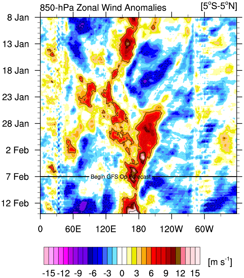
More updates from the ENSO world. Major WWB set to happen over the IDL. This doesn't occur in fading Nino->Nina events. They happen (most of the time) during growing +ENSO (Nino) for the rest of the year, or they are a continuation of a "double dip" event. This is newsworthy for Spring and Summer.
6 likes
The above post and any post by Ntxw is NOT an official forecast and should not be used as such. It is just the opinion of the poster and may or may not be backed by sound meteorological data. It is NOT endorsed by any professional institution including Storm2k. For official information, please refer to NWS products.
Help support Storm2K!
Help support Storm2K!
-
cheezyWXguy
- Category 5
- Posts: 6280
- Joined: Mon Feb 13, 2006 12:29 am
- Location: Dallas, TX
Re: Texas Winter 2018-2019
Texas Snow wrote:The 18Z NAM actually expands the snow coverage area slightly over the 12Z. At least on the 12K, to clarify. Where are you looking, the 3K perhaps?
Yeah I was, I can't believe theyre that different. While I'm happy to see at least the 12km is in our favor, it concerns me that the higher resolution version isn't.
1 likes
-
missygirl810

- Tropical Storm

- Posts: 154
- Joined: Fri Oct 27, 2017 3:07 pm
- Location: Celeste TX Hunt County Fannin Co line
Re: Texas Winter 2018-2019
Ralph's Weather wrote:missygirl810 wrote:orangeblood wrote:
Yep, it is very puzzling to say the least...It's been a long time since I've seen the ENS members this aggressive and we're not talking 10 days out either, it's less than 48 hrs. FW NWS better be on their A game or this could catch a lot of people off guard with their forecast!!
http://i65.tinypic.com/2drcih1.jpg
Ok, I don't understand that graphic at all lol.
It shows the Euro ensemble members snow forecast for DFW. The top graph has each of the 50 members on the y axis and time is the X axis. The colors correspond to the amount of snow predicted by that member through the given time. The bottom graph shows the ensemble mean. Y axis is snow amount and x axis is time in hours from the initial time the model was ran (last night).
Thanks!!!
0 likes
-
Brent
- S2K Supporter
- Posts: 38715
- Age: 37
- Joined: Sun May 16, 2004 10:30 pm
- Location: Tulsa Oklahoma
- Contact:
Re: Texas Winter 2018-2019
cheezyWXguy wrote:Texas Snow wrote:The 18Z NAM actually expands the snow coverage area slightly over the 12Z. At least on the 12K, to clarify. Where are you looking, the 3K perhaps?
Yeah I was, I can't believe theyre that different. While I'm happy to see at least the 12km is in our favor, it concerns me that the higher resolution version isn't.
yeah I'm still concerned it'll be too dry for the metro, could see a lot of virga
That will be why it doesn't snow(if it doesn't), not the temps
2 likes
#neversummer
-
wxman57

- Moderator-Pro Met

- Posts: 23170
- Age: 68
- Joined: Sat Jun 21, 2003 8:06 pm
- Location: Houston, TX (southwest)
Re: Texas Winter 2018-2019
Ntxwx wrote:cheezyWXguy wrote:18z NAM is dryer for DFW, no precip at all.
I might be reading it wrong but it looks to me like it’s showing 2-4” across tarrant county with temps around 30-31 tomorrow night.
Use the total positive snow depth change map:
https://www.tropicaltidbits.com/analysis/models/namconus/2019020718/namconus_asnowd_scus_20.png
1 likes

Re: Texas Winter 2018-2019
National Weather Service Houston/Galveston TX
347 PM CST Thu Feb 7 2019
.DISCUSSION...
Odds are, any
precip that is generated evaporates/sublimates and nothing reaches
the surface. This would be in line with what the HRRR and RAP
suggest. Indeed, the general trend in the models is a drier one.
Still...that dry air allows for a wet bulb profile that is
entirely below zero...and just screams to me, "lots of people are
gonna get cell phone video of about 10 sleet pellets pinging off
tin roofs and cars". So, in deference to the fact that if we get
enough precip to evaporate and saturate a wet bulb profile, a few
sleet pellets might just survive to the ground. Indeed, if we`re
cold enough that ice crystals are generated, there`s an even
smaller chance of a snowflake or two. I begrudgingly added these
to the grids in the morning, on the off chance it happens. Very
high confidence that even if some frozen precip is observed, that
impacts will be nil.
0 likes
-
cheezyWXguy
- Category 5
- Posts: 6280
- Joined: Mon Feb 13, 2006 12:29 am
- Location: Dallas, TX
Re: Texas Winter 2018-2019
Brent wrote:cheezyWXguy wrote:Texas Snow wrote:The 18Z NAM actually expands the snow coverage area slightly over the 12Z. At least on the 12K, to clarify. Where are you looking, the 3K perhaps?
Yeah I was, I can't believe theyre that different. While I'm happy to see at least the 12km is in our favor, it concerns me that the higher resolution version isn't.
yeah I'm still concerned it'll be too dry for the metro, could see a lot of virga
That will be why it doesn't snow(if it doesn't), not the temps
If the 18z 3k NAM is correct, you're right as well. To me, the 12z and 18z 3km look very similar in their soundings, but once precip breaks out in the metro, 850mb and below cools and saturates rapidly. My question is, what is the main difference between the two runs, that causes precip to break out on the 12z, that doesn't happen on the 18z?
0 likes
-
Ralph's Weather
- S2K Supporter
- Posts: 3371
- Age: 38
- Joined: Fri Dec 13, 2013 11:55 am
- Location: Lindale, TX
- Contact:
Re: Texas Winter 2018-2019
I wonder if someone down around Say Henderson or Rusk sees any sleet pellets? The precip is forming at around 925 where it is right around freezing. Doubt it but curious. Fingers crossed that there is enough lift tomorrow to overcome the surface based dry air.
0 likes
Follow on Facebook at Ralph's Weather.

Who is online
Users browsing this forum: No registered users and 62 guests