Southern Plains winter wx thread (2009-2010)
Moderator: S2k Moderators
Forum rules
 The posts in this forum are NOT official forecast and should not be used as such. They are just the opinion of the poster and may or may not be backed by sound meteorological data. They are NOT endorsed by any professional institution or STORM2K.

The posts in this forum are NOT official forecast and should not be used as such. They are just the opinion of the poster and may or may not be backed by sound meteorological data. They are NOT endorsed by any professional institution or STORM2K.
-
Extremeweatherguy

- Category 5

- Posts: 11095
- Joined: Mon Oct 10, 2005 8:13 pm
- Location: Florida

Re: Southern Plains winter wx thread (2009-2010)
Looks like Dallas won't get any snow next week, ugh. This winter has been as good as it has been bad, if that makes sense.
0 likes

Re: Southern Plains winter wx thread (2009-2010)
iorange55 wrote:Looks like Dallas won't get any snow next week, ugh. This winter has been as good as it has been bad, if that makes sense.
I feel your pain. In spite of the favorable pattern; frozen/freezing precip has been hard to come by here on the east side of the metroplex so far this winter. Aside from 1 1/2" of snow on Christmas eve, we've only seen trace amounts. Still, given that many expect for us to be in a pattern that is favorable for winter weather for the next several weeks, I'll be surprised if we don't get at least one moderately disruptive snow or icing event before all is said and done.
0 likes
-
Extremeweatherguy
- Category 5
- Posts: 11095
- Joined: Mon Oct 10, 2005 8:13 pm
- Location: Florida
The 00z NAM is now starting to get on board with the idea of a potentially major winter storm in Oklahoma on Monday..
http://www.nco.ncep.noaa.gov/pmb/nwprod ... p_060l.gif
http://www.nco.ncep.noaa.gov/pmb/nwprod ... p_066l.gif
http://www.nco.ncep.noaa.gov/pmb/nwprod ... p_072l.gif
http://www.nco.ncep.noaa.gov/pmb/nwprod ... p_078l.gif
Earlier runs looked much warmer with mostly just rain, but the 18z and now the 00z have trended progressively colder and look good for snow over a large section of the state.
0 likes
-
msstateguy83
-
Extremeweatherguy
- Category 5
- Posts: 11095
- Joined: Mon Oct 10, 2005 8:13 pm
- Location: Florida
00z model run snow depth maps valid 84 hours from now (next Tuesday morning)..
NAM:
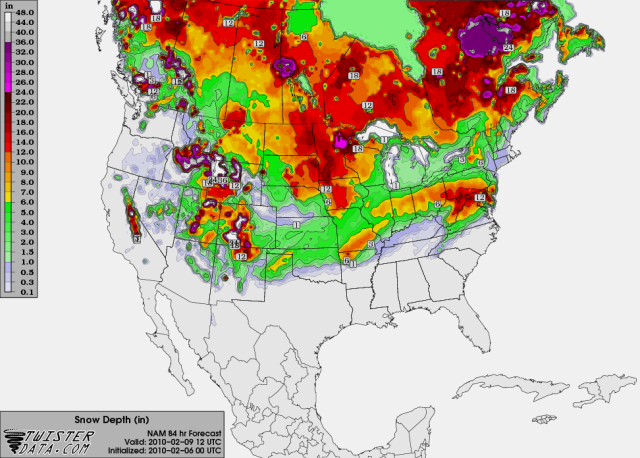
While not overly impressive (3-6" north Oklahoma, 1-3" central Oklahoma, 0-1" south Oklahoma), it should be noted that this is a big shift south from earlier runs. The 12z run of the NAM cut the southern extent of the accumulating snow off near the OK/KS border, whereas this run cuts the southern extent of the accumulations off several hundred miles further south (just north of the Red River).
GFS:
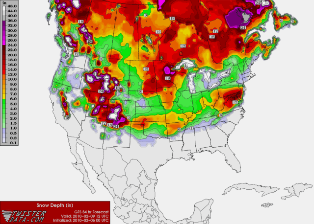
The GFS looks a little more impressive overall than the NAM, showing snow totals topping 12" in northwest Oklahoma and sending the edge of the accumulation line into extreme north Texas. Accumulations for OKC wouldn't be too terrible based on this run, generally just a few inches, but the increased winds on Monday would make it seem a little bit worse since there would be lots of blowing snow and some minor drifting.
NAM:
While not overly impressive (3-6" north Oklahoma, 1-3" central Oklahoma, 0-1" south Oklahoma), it should be noted that this is a big shift south from earlier runs. The 12z run of the NAM cut the southern extent of the accumulating snow off near the OK/KS border, whereas this run cuts the southern extent of the accumulations off several hundred miles further south (just north of the Red River).
GFS:
The GFS looks a little more impressive overall than the NAM, showing snow totals topping 12" in northwest Oklahoma and sending the edge of the accumulation line into extreme north Texas. Accumulations for OKC wouldn't be too terrible based on this run, generally just a few inches, but the increased winds on Monday would make it seem a little bit worse since there would be lots of blowing snow and some minor drifting.
0 likes


Re: Southern Plains winter wx thread (2009-2010)
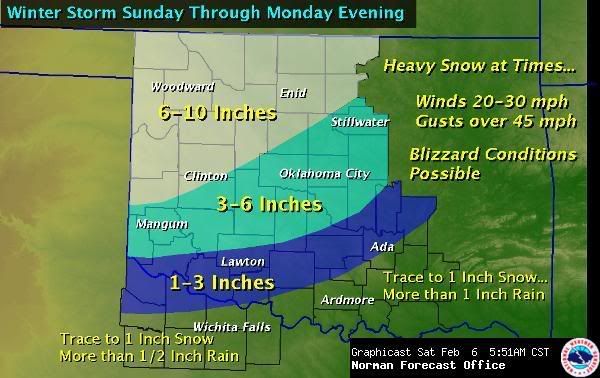
NWS in OKC is using the 'blizzard' word. That storm looks to be impressive even without the high snowfall totals.
.DISCUSSION...
I GUESS TO START THINGS OFF...WE HAVE ISSUED A WINTER STORM WATCH
FOR A LARGE PORTION OF OKLAHOMA. THE WATCH WILL BEGIN SUNDAY
AFTERNOON ACROSS NORTHERN AND WESTERN SECTIONS OF OKLAHOMA...AND
THEN SPREAD INTO SOUTHWEST THROUGH CENTRAL OKLAHOMA ON MONDAY. WE
WERE FAIRLY LIBERAL WITH THE WATCH...BRINGING AS FAR SOUTH AS THE
RED RIVER OF SOUTHWEST OKLAHOMA. TREND OF MODELS HAS BEEN TO SHIFT
AXIS OF HEAVIER SNOW SOUTHWARD DUE TO SLOWER TIMING OF MID-LEVEL
TROUGH AND STEADY PROGRESSION OF COLD AIR. ALTHOUGH THERE WILL
LIKELY BE SOME FAIRLY SIGNIFICANT SNOW TOTALS OVER
OKLAHOMA...THERE IS SOME GOOD NEWS. IT CONTINUES TO APPEAR THAT
THE THREAT OF ANY SIGNIFICANT ICE ACCUMULATIONS IS VERY LOW. THIS
EVEN LOOKS VERY MUCH LIKE A RAIN OR RAIN/SLEET TO SNOW TRANSITION.
HOWEVER...WE ARE BECOMING INCREASINGLY CONCERNED ABOUT BLIZZARD OR
NEAR BLIZZARD CONDITIONS MONDAY AFTERNOON. FOR INSTANCE...WE
CURRENTLY BELIEVE THAT THE METRO AREAS OF LAWTON AND OKC WILL WAKE
UP WITH A COLD RAIN MONDAY MORNING...BUT BY/DURING MONDAY AFTERNOON
SCHOOL/RELEASE-RUSH HOUR...WE VERY WELL COULD SEE SIGNIFICANT SNOW
AND BLOWING SNOW. SOMETHING TO KEEP IN MIND FOR DECISION MAKERS.
THE TRULY CANADIAN AIR WILL SURGE IN MONDAY EVENING AND MONDAY
NIGHT...MAKING FOR VERY COLD CONDITIONS/WIND CHILLS...SOME WELL
BELOW ZERO.
0 likes
The above post and any post by Ntxw is NOT an official forecast and should not be used as such. It is just the opinion of the poster and may or may not be backed by sound meteorological data. It is NOT endorsed by any professional institution including Storm2k. For official information, please refer to NWS products.
Help support Storm2K!
-
Extremeweatherguy
- Category 5
- Posts: 11095
- Joined: Mon Oct 10, 2005 8:13 pm
- Location: Florida
Pretty impressive forecast from the NWS this morning. It seems like they are being a little more bullish than the models (which are currently now showing <1" for OKC)..
Last edited by Extremeweatherguy on Sat Feb 06, 2010 12:27 pm, edited 1 time in total.
0 likes
-
wx247

- S2K Supporter

- Posts: 14279
- Age: 42
- Joined: Wed Feb 05, 2003 10:35 pm
- Location: Monett, Missouri
- Contact:
Models right now are in the "bleh" mode. This time period before an event seems to be when we see them doing some weird things, only to see them right the wrong. Last week's storm had the same thing happen. The system wasn't sampled all that accurately based off of the 12z models. I am curious as to what the 0z does.
0 likes
Personal Forecast Disclaimer:
The posts in this forum are NOT official forecast and should not be used as such. They are just the opinion of the poster and may or may not be backed by sound meteorological data. They are NOT endorsed by any professional institution or storm2k.org. For official information, please refer to the NHC and NWS products.
The posts in this forum are NOT official forecast and should not be used as such. They are just the opinion of the poster and may or may not be backed by sound meteorological data. They are NOT endorsed by any professional institution or storm2k.org. For official information, please refer to the NHC and NWS products.
-
Extremeweatherguy
- Category 5
- Posts: 11095
- Joined: Mon Oct 10, 2005 8:13 pm
- Location: Florida
Hmm. The 00z NAM is odd to say the least. The run looks pretty good for wintry precipitation on Monday for a good chunk of Oklahoma, but the snow accumulation graphic being produced is showing 0" for the central part of the state during the event. Doesn't make too much sense.
Hour 36 = http://www.nco.ncep.noaa.gov/pmb/nwprod ... p_036l.gif
Hour 42 = http://www.nco.ncep.noaa.gov/pmb/nwprod ... p_042l.gif
Hour 48 = http://www.nco.ncep.noaa.gov/pmb/nwprod ... p_048l.gif
Hour 54 = http://www.nco.ncep.noaa.gov/pmb/nwprod ... p_054l.gif
Snow accumulation graphic for hour 54 = http://www.twisterdata.com/data/models/ ... URFACE.png
0 likes
-
wx247
- S2K Supporter
- Posts: 14279
- Age: 42
- Joined: Wed Feb 05, 2003 10:35 pm
- Location: Monett, Missouri
- Contact:
I don't buy that snow depth map. Something has been off on its calculation for the last couple of days.
0 likes
Personal Forecast Disclaimer:
The posts in this forum are NOT official forecast and should not be used as such. They are just the opinion of the poster and may or may not be backed by sound meteorological data. They are NOT endorsed by any professional institution or storm2k.org. For official information, please refer to the NHC and NWS products.
The posts in this forum are NOT official forecast and should not be used as such. They are just the opinion of the poster and may or may not be backed by sound meteorological data. They are NOT endorsed by any professional institution or storm2k.org. For official information, please refer to the NHC and NWS products.
-
Extremeweatherguy
- Category 5
- Posts: 11095
- Joined: Mon Oct 10, 2005 8:13 pm
- Location: Florida
The 00z GFS snowfall map at hour 54 looks a little bit more realistic IMO..
http://www.twisterdata.com/data/models/ ... URFACE.png
It could still be a bit on the low side though if the cold air can work in a little faster and/or the precipitation can hang around a little longer.
http://www.twisterdata.com/data/models/ ... URFACE.png
It could still be a bit on the low side though if the cold air can work in a little faster and/or the precipitation can hang around a little longer.
0 likes
Re:
Extremeweatherguy wrote:The 00z GFS snowfall map at hour 54 looks a little bit more realistic IMO..
http://www.twisterdata.com/data/models/ ... URFACE.png
It could still be a bit on the low side though if the cold air can work in a little faster and/or the precipitation can hang around a little longer.
I think the problem is that the models tonight have trended in lesser amounts of precip which is located mostly in the warm sector further south. Not sure if this is exactly it but could be an explanation.
0 likes
The above post and any post by Ntxw is NOT an official forecast and should not be used as such. It is just the opinion of the poster and may or may not be backed by sound meteorological data. It is NOT endorsed by any professional institution including Storm2k. For official information, please refer to NWS products.
Help support Storm2K!
Help support Storm2K!
-
Extremeweatherguy
- Category 5
- Posts: 11095
- Joined: Mon Oct 10, 2005 8:13 pm
- Location: Florida
Below is my initial snowfall forecast for this event. Currently my forecasted totals lie somewhere in between the lower-end model numbers and the higher-end NWS forecast. It should be noted though that significant shifts are possible during the coming 24-36 hour period depending on how the storm system actually unfolds. If the atmospheric column cools faster than currently predicted, then the area of higher snow totals will need to be expanded southward (and vice versa). This will be something to watch closely.
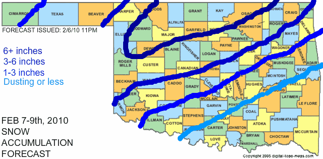
**Snow drifts will be higher than the actual accumulations. Expect drifts to 1' in the 1-6" area and up to 2' in the 6"+ area.**
**Snow drifts will be higher than the actual accumulations. Expect drifts to 1' in the 1-6" area and up to 2' in the 6"+ area.**
The following post is NOT an official forecast and should not be used as such. It is just the opinion of the poster and may or may not be backed by sound meteorological data. It is NOT endorsed by any professional institution including storm2k.org. For official information, please refer to NWS products.
0 likes
-
Extremeweatherguy
- Category 5
- Posts: 11095
- Joined: Mon Oct 10, 2005 8:13 pm
- Location: Florida
The 6z NAM looks to be coming in colder/wetter than the 0z, but the snowfall map only looks slightly better. Instead of showing 0" for central Oklahoma, it now shows a dusting. lol. It still seems a bit odd though. I would expect much higher snow totals if the NAM's 850mb/precipitation output were to play out. I think the problem might be that the NAM expects the drop in surface temperatures to lag behind the drop in 850mb numbers. I somewhat doubt that will happen though. With a low like this and precipitation falling, I suspect that surface temperatures will follow the 850mb temperatures fairly closely during the day on Monday and not lag behind as the NAM seems to be suggesting.
6z NAM output
Hour 30 = http://www.nco.ncep.noaa.gov/pmb/nwprod ... p_030l.gif
Hour 36 = http://www.nco.ncep.noaa.gov/pmb/nwprod ... p_036l.gif
Hour 42 = http://www.nco.ncep.noaa.gov/pmb/nwprod ... p_042l.gif
Hour 48 = http://www.nco.ncep.noaa.gov/pmb/nwprod ... p_048l.gif
Snow accumulation graphic for hour 48 = http://www.twisterdata.com/data/models/ ... URFACE.png
0 likes
-
Extremeweatherguy
- Category 5
- Posts: 11095
- Joined: Mon Oct 10, 2005 8:13 pm
- Location: Florida
The 12z GFS and NAM continue to look more impressive overall, however the NAM snow map is still really strange and shows 0" for a good chunk of Oklahoma even though it has OKC near or north of the 540 thickness line and the 850mb 0C line (with precipitation) for an extended period on Monday. It just doesn't make sense.
odd NAM snow map: http://www.twisterdata.com/data/models/ ... URFACE.png
The latest GFS snow map on the other hand looks a lot better: http://www.twisterdata.com/data/models/ ... URFACE.png
odd NAM snow map: http://www.twisterdata.com/data/models/ ... URFACE.png
The latest GFS snow map on the other hand looks a lot better: http://www.twisterdata.com/data/models/ ... URFACE.png
0 likes
-
Extremeweatherguy
- Category 5
- Posts: 11095
- Joined: Mon Oct 10, 2005 8:13 pm
- Location: Florida
Latest discussion from the Norman NWS office...
AREA FORECAST DISCUSSION
NATIONAL WEATHER SERVICE NORMAN OK
1139 AM CST SUN FEB 7 2010
.UPDATE...
FREEZING TEMPERATURES LATE THIS MORNING (SURFACE) ARE GENERALLY
CONFINED TO WEST CENTRAL/NORTHWEST OKLAHOMA. A FEW AREAS MAY
STRUGGLE TO REACH 33 DEGREES THIS AFTERNOON. MODEL DRY MID LEVELS
SOME THIS AFTERNOON...SO FREEZING DRIZZLE VERY LIGHT FREEZING
RAIN MAY OCCUR THIS AFTERNOON FAR NORTHWEST. UPDATED GRIDS TO
ADD FREEZING PRECIP AND SNOW. BETTER CHANCE OF PRECIP WILL
OCCUR THIS EVENING AND OVERNIGHT AS UPPER TROUGH APPROACHES.
STILL A COMPLICATED FORECAST WITH REGARDS TO RAIN CHANGING TO
SNOW AND SNOWFALL/SNOW DEPTH AMOUNTS. LIKELY WILL SEE A BAND
OR TWO OF MODERATE/HEAVY SNOW LATE SUNDAY INTO MONDAY. HEAVY
PRECIP RATES COULD FAVOR MOD/HEAVY WET SNOW WITH SURFACE TEMPS 32-33.
IMPACT ON ROADS MAY BE HEAVY SLUSH WHICH INITIALLY COULD BE A
MINOR/MODERATE TRAFFIC ISSUE. STRONG COLD AIR ADVECTION MONDAY
NIGHT WILL FREEZE SLUSH/WET ROADS. MOST LIKELY AREA FOR THIS TO
OCCUR...PER GFS...WOULD BE CLINTON...KINGFISHER STILLWATER. A
SOUTHERN PUSH TO THIS AREA IS ALSO POSSIBLE/LIKELY.
SNOWFALL VS SNOW DEPTH WITH WET SNOW...WILL ALSO BE INTERESTING.
FOR NOW...NO MAJOR CHANGES TO SUNDAY NIGHT INTO MONDAY.
0 likes
-
Extremeweatherguy
- Category 5
- Posts: 11095
- Joined: Mon Oct 10, 2005 8:13 pm
- Location: Florida
The NAM continues to have some serious problems IMO. The 850mb temperatures and thicknesses look good for snow tomorrow in central Oklahoma, but for some reason it is trying to show surface temperatures up near 40F for a good chunk of the day and 0 inches of snow accumulation. These surface temperature values seem too high though, and that is being proven this afternoon. The 18z NAM is calling for it to be 45.5F at the Norman, OK site at 3pm today, but as of 2:29pm it is only 37.2F in Norman (according to the mesonet). This means that the NAM will be off by nearly 8-9 degrees! If these same surface temperature errors are present tomorrow, and I think they will be, then the 40F the NAM is forecasting for Monday afternoon will probably wind up being closer to 31-32F. This crucial difference should allow the snow to reach the surface and accumulate, thus verifying the current forecasts being put out by the NWS, myself, and most other sources.
Update: The actual 3pm temperature wound up being 36.7F at the Norman site. The NAM was off by +8.8F.
Update: The actual 3pm temperature wound up being 36.7F at the Norman site. The NAM was off by +8.8F.
Last edited by Extremeweatherguy on Sun Feb 07, 2010 4:09 pm, edited 2 times in total.
0 likes
-
srainhoutx

- S2K Supporter
- Posts: 6919
- Age: 68
- Joined: Sun Jan 14, 2007 11:34 am
- Location: Haywood County, NC
- Contact:
Re: Southern Plains winter wx thread (2009-2010)
I agree EWG. The models are once again under estimating the cold. That will have big implications down the road as well.
0 likes
Carla/Alicia/Jerry(In The Eye)/Michelle/Charley/Ivan/Dennis/Katrina/Rita/Wilma/Ike/Harvey
Member: National Weather Association
Wx Infinity Forums
http://wxinfinity.com/index.php
Facebook.com/WeatherInfinity
Twitter @WeatherInfinity
Member: National Weather Association
Wx Infinity Forums
http://wxinfinity.com/index.php
Facebook.com/WeatherInfinity
Twitter @WeatherInfinity
-
msstateguy83
i was thinking the samething the nam does NOT in any way shape or form add up w/the surface temps NO WAY will temps be that warm by tomorrow afternoon... i would even argue to take the snow line with accum snows as far south as along the redriver even maybe my area.. we will see how this pans out but it could be very interesting to say the least!
edit: further more i think the models in general are having a hard time with the arctic air during the week as awhole, i expect temps to be much colder the next
7 days... which could spell more trouble later in the week...
edit: further more i think the models in general are having a hard time with the arctic air during the week as awhole, i expect temps to be much colder the next
7 days... which could spell more trouble later in the week...
0 likes
Who is online
Users browsing this forum: No registered users and 72 guests