Texas winter wx thread (2009-2010)

Winter Weather Discussion

Moderator: S2k Moderators

Forum rules

The posts in this forum are NOT official forecast and should not be used as such. They are just the opinion of the poster and may or may not be backed by sound meteorological data. They are NOT endorsed by any professional institution or STORM2K.

Help Support Storm2K
Message
Author
User avatar
TrekkerCC
S2K Supporter
S2K Supporter
Posts: 263
Joined: Sat Sep 06, 2003 10:19 pm
Location: North Central Texas (Dallas Area)

Re: Texas winter wx thread (2009-2010)

#5501 Postby TrekkerCC » Mon Feb 08, 2010 12:09 pm

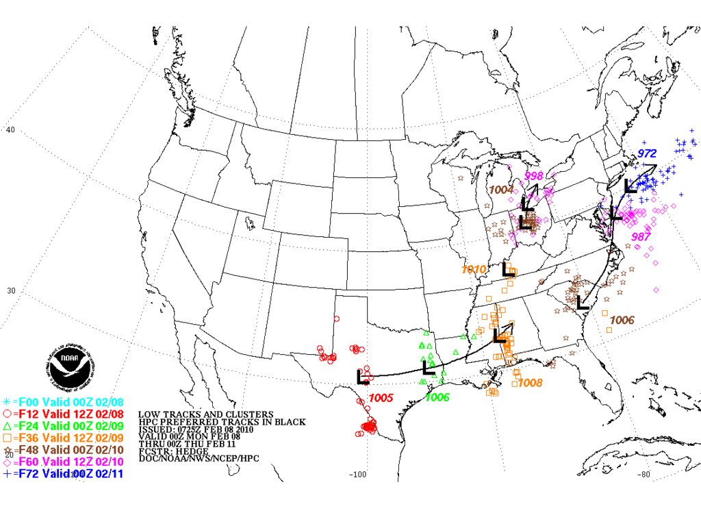
TexasStorm wrote:NWS Fort Worth does not seem to be on board with this whole scenario for Thursday. Afternoon update should be interesting after they have had time to look at the new models.


While the ECMWF and CMC starting to line up with the GFS is encouraging, I doubt they will get real excited until Wednesday or so (more model support would probably make them more confident) as there are still huge questions about moisture availability, track of the upper level low, and other factors critical to forecast this upcoming weather system. I am sure FWD would like to error on the conservative side, rather than calling for a winter storm and then have nothing happen. However, I am becoming a bit more cautiously optimistic right now that we will see at least a half-inch of snow.
0 likes   
Storm2K Forecast Disclaimer:

This post is NOT AN OFFICIAL FORECAST and should not be used as such. It is just the opinion of the poster and may or may not be backed by sound meteorological data. It is NOT endorsed by any professional institution including storm2k.org. For Official Information please refer to the NHC and NWS products.

PineyWoods
Tropical Storm
Tropical Storm
Posts: 120
Joined: Sat Feb 03, 2007 3:39 pm
Location: Tyler

Re: Texas winter wx thread (2009-2010)

#5502 Postby PineyWoods » Mon Feb 08, 2010 12:22 pm

For those in East Texas, just a little snippet from the Shreveport NWS -

"AREA FORECAST DISCUSSION
NATIONAL WEATHER SERVICE SHREVEPORT LA
1022 AM CST MON FEB 8 2010

.DISCUSSION...
COLD AIR WEDGE AT THE SURFACE HOLDING STRONG FROM A TYLER TO
NATCHITOCHES LINE AND WITH THE OVERRUNNING PATTERN SETTING
UP...HAVE A HARD TIME GETTING TEMPS NORTH OF THE I20 CORRIDOR INTO
THE 50S THIS AFTERNOON. HAVE BACKED TEMPS DOWN A FEW DEGREES
ACROSS THE NORTHERN HALF. AREAS SOUTH AND WEST CLOSER TO THE
SURFACE LOW TRACK WILL WARM UP SIGNIFICANTLY TODAY. LFK ALREADY
53 AT 10 AM WITH STRONG WAA IN ADVANCE OF THE SURFACE LOW NEAR
WACO. DONT FORSEE A LOT OF CHANGES TO THE FORECAST WITH SHOWERS
OVERTAKING THE ENTIRE REGION THROUGH THE DAY AND EVEN SOME THUNDER
ACROSS THE SOUTHERN COUNTIES AND PARISHES. TEMPS NORTH OF I30 JUST
BARELY HOLDING ABOVE FREEZING AND WON`T WARM MUCH TODAY. THERE IS
A CHANCE OF A QUICK CHANGEOVER LATE TONIGHT ACROSS THE NORTH BUT
IT APPEARS THAT THE MOISTURE WILL BE EXITING AS THE COLD AIR
FILTERS IN SO NO MAJOR ACCUMULATIONS ARE EXPECTED.


THURSDAY AND FRIDAY CONTINUE TO LOOK INTERESTING FROM A WINTER
WEATHER PERSPECTIVE. NEW 12Z GFS CONTINUES INDICATE PRECIPITATION
FALLING INTO A COLD AIRMASS AHEAD OF ANOTHER SHORTWAVE. WILL
DISCUSS THAT WITH THE AFTERNOON PACKAGE.
"

Would be nice to get a little snow here in the Tyler area. :)
0 likes   

User avatar
Big O
Category 1
Category 1
Posts: 252
Age: 53
Joined: Sun Sep 16, 2007 4:40 pm
Location: McAllen, Texas

Re: Texas winter wx thread (2009-2010)

#5503 Postby Big O » Mon Feb 08, 2010 12:34 pm

I haven't seen this discussed yet, but doesn't the 0z European (days 9-10), show a deep trough over the central CONUS and Texas? What are the implications if this verifies?
0 likes   

User avatar
srainhoutx
S2K Supporter
S2K Supporter
Posts: 6919
Age: 66
Joined: Sun Jan 14, 2007 11:34 am
Location: Haywood County, NC
Contact:

Re: Texas winter wx thread (2009-2010)

#5504 Postby srainhoutx » Mon Feb 08, 2010 12:39 pm

Big O wrote:I haven't seen this discussed yet, but doesn't the 0z European (days 9-10), show a deep trough over the central CONUS and Texas? What are the implications if this verifies?


You are correct Big O. I would like to see another run or two from the ECMWF, but it does fit well with the MMW event as well an a severely tanking AO, NOA -EPO and +PNA seen in ensembles. Don Sutherland has been updating for those that would like to follow. :wink:

viewtopic.php?f=22&t=107373&start=80
0 likes   
Carla/Alicia/Jerry(In The Eye)/Michelle/Charley/Ivan/Dennis/Katrina/Rita/Wilma/Ike/Harvey

Member: National Weather Association
Wx Infinity Forums
http://wxinfinity.com/index.php

Facebook.com/WeatherInfinity
Twitter @WeatherInfinity

User avatar
mike mclennan county
Tropical Wave
Tropical Wave
Posts: 2
Age: 53
Joined: Mon Feb 08, 2010 12:36 pm
Location: Eddy, TX

Re: Texas winter wx thread (2009-2010)

#5505 Postby mike mclennan county » Mon Feb 08, 2010 12:46 pm

Big O wrote:I haven't seen this discussed yet, but doesn't the 0z European (days 9-10), show a deep trough over the central CONUS and Texas? What are the implications if this verifies?

:cold:
0 likes   

User avatar
wxman57
Moderator-Pro Met
Moderator-Pro Met
Posts: 22512
Age: 66
Joined: Sat Jun 21, 2003 8:06 pm
Location: Houston, TX (southwest)

Re: Texas winter wx thread (2009-2010)

#5506 Postby wxman57 » Mon Feb 08, 2010 12:47 pm

Big O wrote:I haven't seen this discussed yet, but doesn't the 0z European (days 9-10), show a deep trough over the central CONUS and Texas? What are the implications if this verifies?


It means I'll be miserable for at least another 2 weeks. I.E., lots of cold air across the country east of the Rockies.
0 likes   

HockeyTx82
S2K Supporter
S2K Supporter
Posts: 2035
Joined: Tue Oct 27, 2009 11:17 am
Location: Ponder, TX

Re: Texas winter wx thread (2009-2010)

#5507 Postby HockeyTx82 » Mon Feb 08, 2010 12:49 pm

wxman57 wrote:
Big O wrote:I haven't seen this discussed yet, but doesn't the 0z European (days 9-10), show a deep trough over the central CONUS and Texas? What are the implications if this verifies?


It means I'll be miserable for at least another 2 weeks. I.E., lots of cold air across the country east of the Rockies.


Forgive my ignorance, but when you say east of the Rockies does that mean Canada all the way down to Texas eastward?
0 likes   
Don't hold me accountable for anything I post on this forum. Leave the real forecasting up to the professionals.

Location: Ponder, TX (all observation posts are this location unless otherwise noted)

User avatar
wxman57
Moderator-Pro Met
Moderator-Pro Met
Posts: 22512
Age: 66
Joined: Sat Jun 21, 2003 8:06 pm
Location: Houston, TX (southwest)

Re: Texas winter wx thread (2009-2010)

#5508 Postby wxman57 » Mon Feb 08, 2010 12:52 pm

HockeyTx82 wrote:
wxman57 wrote:
Big O wrote:I haven't seen this discussed yet, but doesn't the 0z European (days 9-10), show a deep trough over the central CONUS and Texas? What are the implications if this verifies?


It means I'll be miserable for at least another 2 weeks. I.E., lots of cold air across the country east of the Rockies.


Forgive my ignorance, but when you say east of the Rockies does that mean Canada all the way down to Texas eastward?


Yep.
0 likes   

Ntxw
Storm2k Moderator
Storm2k Moderator
Posts: 21565
Joined: Wed Oct 21, 2009 6:34 pm
Location: DFW, Texas

Re: Texas winter wx thread (2009-2010)

#5509 Postby Ntxw » Mon Feb 08, 2010 12:54 pm

Hmm, lets see if we can shift any of this south a bit more! For once the eastplexers could be the bullseye :D

12z gfs

Image
0 likes   
The above post and any post by Ntxw is NOT an official forecast and should not be used as such. It is just the opinion of the poster and may or may not be backed by sound meteorological data. It is NOT endorsed by any professional institution including Storm2k. For official information, please refer to NWS products.

  Help support Storm2K!
Help Support Storm2K

User avatar
mike mclennan county
Tropical Wave
Tropical Wave
Posts: 2
Age: 53
Joined: Mon Feb 08, 2010 12:36 pm
Location: Eddy, TX

#5510 Postby mike mclennan county » Mon Feb 08, 2010 12:56 pm

TUESDAY...MUCH COLDER AIR IS IN PLACE ACROSS THE REGION AS AN
ARCTIC FRONT WILL HAVE SWEPT THROUGH THE AREA BY MONDAY NIGHT. AT
THE SAME TIME...MODELS ARE IN GOOD AGREEMENT WITH ANOTHER LOW
DIGGING SOUTHWARD ALONG THE WESTERN U.S. COAST. GFS40/ECMWF ARE IN
FAIRLY GOOD AGREEMENT WITH THE PATH OF THIS LOW THROUGH LATE THIS
WEEK...BRINGING IT EAST ACROSS THE DESERT SOUTHWEST...AND THEN
OVER WEST CENTRAL TEXAS THURSDAY.

THIS WILL BE A GOOD SET UP FOR THE POSSIBILITY OF A WINTER
WEATHER EVENT. AT THIS POINT...WHILE THE MODELS ARE IN GOOD
AGREEMENT ON THE PATH AND TIMING OF THE SYSTEM...TEMPERATURE
PROFILES FOR OUR AREA ARE STILL UNCERTAIN ENOUGH TO MENTION
MULTIPLE PRECIP TYPES. WE WILL KEEP THE SPS FOR POSSIBLE WINTRY
WEATHER GOING FOR THE AREA.

GRAPHICAL GFS SFC TEMPERATURES FROM TUESDAY THROUGH THURSDAY
STRUGGLE TO REACH THE 40S OVER ANY PART OF THE CWA...AND BUFR
SOUNDINGS BEAR THIS OUT AS WELL. HAVE THEREFORE KEPT TEMPERATURES
THROUGH THE MIDDLE OF THE WEEK SIMILAR TO WHAT WAS IN THE GRIDS
ALREADY. WE WILL BE MUCH COOLER THAN NORMAL FOR HIGH TEMPERATURES.
WHILE OVERNIGHT LOWS WILL BE COOLER THAN NORMAL...AS THE SYSTEM
APPROACHES...MOISTURE WILL BE DRAWN NORTHWESTWARD INTO THE
AREA...WHICH WILL LIMIT HOW COLD WE CAN GET EACH NIGHT AFTER
TUESDAY NIGHT.

From San Angelo Discussion
0 likes   

User avatar
Portastorm
Storm2k Moderator
Storm2k Moderator
Posts: 9788
Age: 62
Joined: Fri Jul 11, 2003 9:16 am
Location: South Austin, TX
Contact:

Re: Texas winter wx thread (2009-2010)

#5511 Postby Portastorm » Mon Feb 08, 2010 1:02 pm

Of interest ...

Image
0 likes   

HockeyTx82
S2K Supporter
S2K Supporter
Posts: 2035
Joined: Tue Oct 27, 2009 11:17 am
Location: Ponder, TX

Re: Texas winter wx thread (2009-2010)

#5512 Postby HockeyTx82 » Mon Feb 08, 2010 1:03 pm

Portastorm wrote:Of interest ...

Image


What does mean in terms of precip totals and types?
0 likes   
Don't hold me accountable for anything I post on this forum. Leave the real forecasting up to the professionals.

Location: Ponder, TX (all observation posts are this location unless otherwise noted)

katheria
Category 1
Category 1
Posts: 336
Joined: Mon Dec 28, 2009 10:51 pm
Location: Garland TX

Re: Texas winter wx thread (2009-2010)

#5513 Postby katheria » Mon Feb 08, 2010 1:05 pm

Ntxw wrote:Hmm, lets see if we can shift any of this south a bit more! For once the eastplexers could be the bullseye :D

12z gfs

Image


Shift that dark blue to the rowlett area and ill be doing a happy dance LOL
ill take anything right now thou :)
0 likes   
just a guess.......take everything i say with a grain of salt.......check your local NWS for forecast information

User avatar
Portastorm
Storm2k Moderator
Storm2k Moderator
Posts: 9788
Age: 62
Joined: Fri Jul 11, 2003 9:16 am
Location: South Austin, TX
Contact:

Re: Texas winter wx thread (2009-2010)

#5514 Postby Portastorm » Mon Feb 08, 2010 1:07 pm

:uarrow:

HockeyTx82 ... it means that you have to be feeling good if you live in the DFW area concerning your chances for wintry weather later this week. Anywhere near or just to the north of the low track should get in on the "action."
0 likes   

Ntxw
Storm2k Moderator
Storm2k Moderator
Posts: 21565
Joined: Wed Oct 21, 2009 6:34 pm
Location: DFW, Texas

#5515 Postby Ntxw » Mon Feb 08, 2010 1:08 pm

:uarrow: Can't take that too closely, it only gives a general idea of where the potential is. No way to know for sure locally how much where and when until the event happens Katheria.
0 likes   
The above post and any post by Ntxw is NOT an official forecast and should not be used as such. It is just the opinion of the poster and may or may not be backed by sound meteorological data. It is NOT endorsed by any professional institution including Storm2k. For official information, please refer to NWS products.


  Help support Storm2K!

Help Support Storm2K


HockeyTx82
S2K Supporter
S2K Supporter
Posts: 2035
Joined: Tue Oct 27, 2009 11:17 am
Location: Ponder, TX

Re: Texas winter wx thread (2009-2010)

#5516 Postby HockeyTx82 » Mon Feb 08, 2010 1:20 pm

Found this on the NWS Ft. Worth Site regarding Valentine's Day......

•2007 - Light snow fell in the Metroplex, but measurable snow (generally under 1 inch) accumulated in areas to the north and northwest.
•2004 - Widespread snow fell during the early morning hours, resulting in storm totals of 3 to 5 inches from the Metroplex northward.
•1996 - Temperatures rose to a record breaking 85°F.
•1978 - The largest 24-hour snowfall ever (12.1") began on the following day.
•1969 - There was a trace of freezing rain and sleet.
•1951 - The precipitation record for this holiday occurred with a modest 0.97" however, it was in the form of freezing rain, sleet, and snow. The freezing and/or frozen precipitation amounted to 3.0". The lowest high for the date of 27° was also recorded.
•1949 - Snow melted as it fell.
•1908 - There was a trace of sleet.

http://www.srh.noaa.gov/fwd/?n=dfeb14

Perhaps we are overdue for a repeat of 1978? :froze: wishing........
0 likes   
Don't hold me accountable for anything I post on this forum. Leave the real forecasting up to the professionals.

Location: Ponder, TX (all observation posts are this location unless otherwise noted)

bktkck
Tropical Low
Tropical Low
Posts: 16
Joined: Mon Dec 28, 2009 10:36 am
Location: Tyler, TX

#5517 Postby bktkck » Mon Feb 08, 2010 1:22 pm

I'm in Tyler and we've been north'd and south'd recently so it is nice to see us near the bullseye. I am going to be fired as weatherman at my hospital if nothing comes of this.
0 likes   

Ntxw
Storm2k Moderator
Storm2k Moderator
Posts: 21565
Joined: Wed Oct 21, 2009 6:34 pm
Location: DFW, Texas

#5518 Postby Ntxw » Mon Feb 08, 2010 1:22 pm

I don't think we'll get anything of that magnitude (though locally maybe someone could get a big enough burst to rival?). Nonetheless this shapes up to be a significant if not major snowfall(north Texas standards) at least in coverage. All of the models agree including the latest EC which looks a bit colder (could have implications in southern regions of Texas).
Last edited by Ntxw on Mon Feb 08, 2010 1:23 pm, edited 1 time in total.
0 likes   
The above post and any post by Ntxw is NOT an official forecast and should not be used as such. It is just the opinion of the poster and may or may not be backed by sound meteorological data. It is NOT endorsed by any professional institution including Storm2k. For official information, please refer to NWS products.


  Help support Storm2K!

Help Support Storm2K


User avatar
gboudx
S2K Supporter
S2K Supporter
Posts: 4047
Joined: Thu Sep 04, 2003 1:39 pm
Location: Rockwall, Tx but from Harvey, La

Re: Texas winter wx thread (2009-2010)

#5519 Postby gboudx » Mon Feb 08, 2010 1:23 pm

Ntxw wrote:Hmm, lets see if we can shift any of this south a bit more! For once the eastplexers could be the bullseye :D

12z gfs

Image removed


Is there a website that generates this graphic?

kelarie,

C'mon, us Rowlett/Rockwall folks would be ecstatic with just an inch of sneaux. Let's not get too greedy. ;)
0 likes   

User avatar
TrekkerCC
S2K Supporter
S2K Supporter
Posts: 263
Joined: Sat Sep 06, 2003 10:19 pm
Location: North Central Texas (Dallas Area)

Re: Texas winter wx thread (2009-2010)

#5520 Postby TrekkerCC » Mon Feb 08, 2010 1:28 pm

gboudx wrote:
Ntxw wrote:Hmm, lets see if we can shift any of this south a bit more! For once the eastplexers could be the bullseye :D

12z gfs

Image removed


Is there a website that generates this graphic?

kelarie,

C'mon, us Rowlett/Rockwall folks would be ecstatic with just an inch of sneaux. Let's not get too greedy. ;)


http://www.wxcaster.com is the site in question! Just navigate to the Current Weather Info >> Model Forecast Charts section! An excellent site all around, it is worth spending time looking at the other charts as well.
Last edited by TrekkerCC on Mon Feb 08, 2010 1:28 pm, edited 1 time in total.
0 likes   
Storm2K Forecast Disclaimer:

This post is NOT AN OFFICIAL FORECAST and should not be used as such. It is just the opinion of the poster and may or may not be backed by sound meteorological data. It is NOT endorsed by any professional institution including storm2k.org. For Official Information please refer to the NHC and NWS products.


Return to “Winter Weather”

Who is online

Users browsing this forum: No registered users and 10 guests