Texas winter wx thread (2009-2010)
Moderator: S2k Moderators
Forum rules
 The posts in this forum are NOT official forecast and should not be used as such. They are just the opinion of the poster and may or may not be backed by sound meteorological data. They are NOT endorsed by any professional institution or STORM2K.

The posts in this forum are NOT official forecast and should not be used as such. They are just the opinion of the poster and may or may not be backed by sound meteorological data. They are NOT endorsed by any professional institution or STORM2K.

Re: Texas winter wx thread (2009-2010)
How bout Wise county folks around Thursday? National Weather Service calls for snow and rain mix, with no accumulation.
0 likes

Re: Texas winter wx thread (2009-2010)
Ntxwx wrote:How bout Wise county folks around Thursday? National Weather Service calls for snow and rain mix, with no accumulation.
That's close enough to be within the Metro region. *Potential* for measurable snowfall there too. Track will determine how much. I suspect a lot of changes from the NWS today if not tonight. Barring any drastic changes in the models (which we all know very well can happen).
0 likes
The above post and any post by Ntxw is NOT an official forecast and should not be used as such. It is just the opinion of the poster and may or may not be backed by sound meteorological data. It is NOT endorsed by any professional institution including Storm2k. For official information, please refer to NWS products.
Help support Storm2K!
Re: Texas winter wx thread (2009-2010)
wxman57 wrote:You trying to depress me, srain?
Wxman, would the snow ratios for this event be 10:1?
0 likes
The above post and any post by Ntxw is NOT an official forecast and should not be used as such. It is just the opinion of the poster and may or may not be backed by sound meteorological data. It is NOT endorsed by any professional institution including Storm2k. For official information, please refer to NWS products.
Help support Storm2K!
Help support Storm2K!
-
wxman57

- Moderator-Pro Met

- Posts: 23175
- Age: 68
- Joined: Sat Jun 21, 2003 8:06 pm
- Location: Houston, TX (southwest)
Re: Texas winter wx thread (2009-2010)
Ntxw wrote:wxman57 wrote:You trying to depress me, srain?
Wxman, would the snow ratios for this event be 10:1?
Probably not. Wet snow. Maybe closer to 5:1.
0 likes
Re: Texas winter wx thread (2009-2010)
Getting better, still wording caution.

0 likes
The above post and any post by Ntxw is NOT an official forecast and should not be used as such. It is just the opinion of the poster and may or may not be backed by sound meteorological data. It is NOT endorsed by any professional institution including Storm2k. For official information, please refer to NWS products.
Help support Storm2K!
Help support Storm2K!
-
TrekkerCC

- S2K Supporter

- Posts: 263
- Joined: Sat Sep 06, 2003 10:19 pm
- Location: North Central Texas (Dallas Area)
Re: Texas winter wx thread (2009-2010)
Thanks to Brent for finding this:
This is from the CPC Hazard Assessment for Feb 11 & 12 -

This is from the CPC Hazard Assessment for Feb 11 & 12 -

0 likes
Storm2K Forecast Disclaimer:
This post is NOT AN OFFICIAL FORECAST and should not be used as such. It is just the opinion of the poster and may or may not be backed by sound meteorological data. It is NOT endorsed by any professional institution including storm2k.org. For Official Information please refer to the NHC and NWS products.
This post is NOT AN OFFICIAL FORECAST and should not be used as such. It is just the opinion of the poster and may or may not be backed by sound meteorological data. It is NOT endorsed by any professional institution including storm2k.org. For Official Information please refer to the NHC and NWS products.
Re: Texas winter wx thread (2009-2010)
For those waiting for the big one here in North Texas this could be it.

0 likes
The above post and any post by Ntxw is NOT an official forecast and should not be used as such. It is just the opinion of the poster and may or may not be backed by sound meteorological data. It is NOT endorsed by any professional institution including Storm2k. For official information, please refer to NWS products.
Help support Storm2K!
Help support Storm2K!
-
WacoWx
- Category 2

- Posts: 692
- Joined: Mon Dec 28, 2009 4:14 pm
- Location: NOT Waco, TX ----> Dallas, TX
Re: Texas winter wx thread (2009-2010)
okay, so the scenario that I need for Waco to see ALL snow is for the low to arrive sooner than the models are currently prediciting? The low going further south? Light se winds? I just need something to look for.
0 likes
Re: Texas winter wx thread (2009-2010)
WacoWx wrote:okay, so the scenario that I need for Waco to see ALL snow is for the low to arrive sooner than the models are currently prediciting? The low going further south? Light se winds? I just need something to look for.
Again I think the NWS is conservative, wxman said the transition zone will be very small so if you are colder than expect (aloft and surface) it would be snow if not probably a cold cold rain.
0 likes
The above post and any post by Ntxw is NOT an official forecast and should not be used as such. It is just the opinion of the poster and may or may not be backed by sound meteorological data. It is NOT endorsed by any professional institution including Storm2k. For official information, please refer to NWS products.
Help support Storm2K!
Help support Storm2K!
-
srainhoutx

- S2K Supporter
- Posts: 6919
- Age: 68
- Joined: Sun Jan 14, 2007 11:34 am
- Location: Haywood County, NC
- Contact:
Re: Texas winter wx thread (2009-2010)
wxman57 wrote:You trying to depress me, srain?
I feel your pain. The pool will likely not warm up until June and I refuse to run the 400,00 BTU heater to bring up the temp after last months Natural Gas Bill.

0 likes
Carla/Alicia/Jerry(In The Eye)/Michelle/Charley/Ivan/Dennis/Katrina/Rita/Wilma/Ike/Harvey
Member: National Weather Association
Wx Infinity Forums
http://wxinfinity.com/index.php
Facebook.com/WeatherInfinity
Twitter @WeatherInfinity
Member: National Weather Association
Wx Infinity Forums
http://wxinfinity.com/index.php
Facebook.com/WeatherInfinity
Twitter @WeatherInfinity
-
Texas Snowman

- Storm2k Moderator

- Posts: 6197
- Joined: Fri Jan 25, 2008 11:29 am
- Location: Denison, Texas
Re: Texas winter wx thread (2009-2010)
TrekkerCC wrote:Thanks to Brent for finding this:
This is from the CPC Hazard Assessment for Feb 11 & 12 -
That would seem to put a good portion of North Texas and the Red River Valley where I live under the gun for some significant snowfall. Hope that proves to be reasonably accurate.
Like others in Texas, we've been short-changed here in the Sherman/Denison area as places west and north have received much, much more snow (10 inches during the Christmas Eve storm fell about 45 miles west/northwest of here).
So far, only 2 1/2 inches this winter here in Sherman/Denison. Would like to see one BIG
 storm before the winter is over.
0 likes
The above post and any post by Texas Snowman is NOT an official forecast and should not be used as such. It is just the opinion of the poster and may or may not be backed by sound meteorological data. It is NOT endorsed by any professional institution including storm2k.org. For official information, please refer to NWS products.
-
Texas Snowman
- Storm2k Moderator
- Posts: 6197
- Joined: Fri Jan 25, 2008 11:29 am
- Location: Denison, Texas
Re: Texas winter wx thread (2009-2010)
We did have a HUGE winter rainstorm over night - about 2" here in Sherman/Denison with temps in the upper 30s during the event.
HUGE runoff from this rain, all area stock tanks are more than full, area creeks are bank-full, and some creeks are well out of their banks.
HUGE runoff from this rain, all area stock tanks are more than full, area creeks are bank-full, and some creeks are well out of their banks.
0 likes
The above post and any post by Texas Snowman is NOT an official forecast and should not be used as such. It is just the opinion of the poster and may or may not be backed by sound meteorological data. It is NOT endorsed by any professional institution including storm2k.org. For official information, please refer to NWS products.
-
srainhoutx
- S2K Supporter
- Posts: 6919
- Age: 68
- Joined: Sun Jan 14, 2007 11:34 am
- Location: Haywood County, NC
- Contact:
Re: Texas winter wx thread (2009-2010)
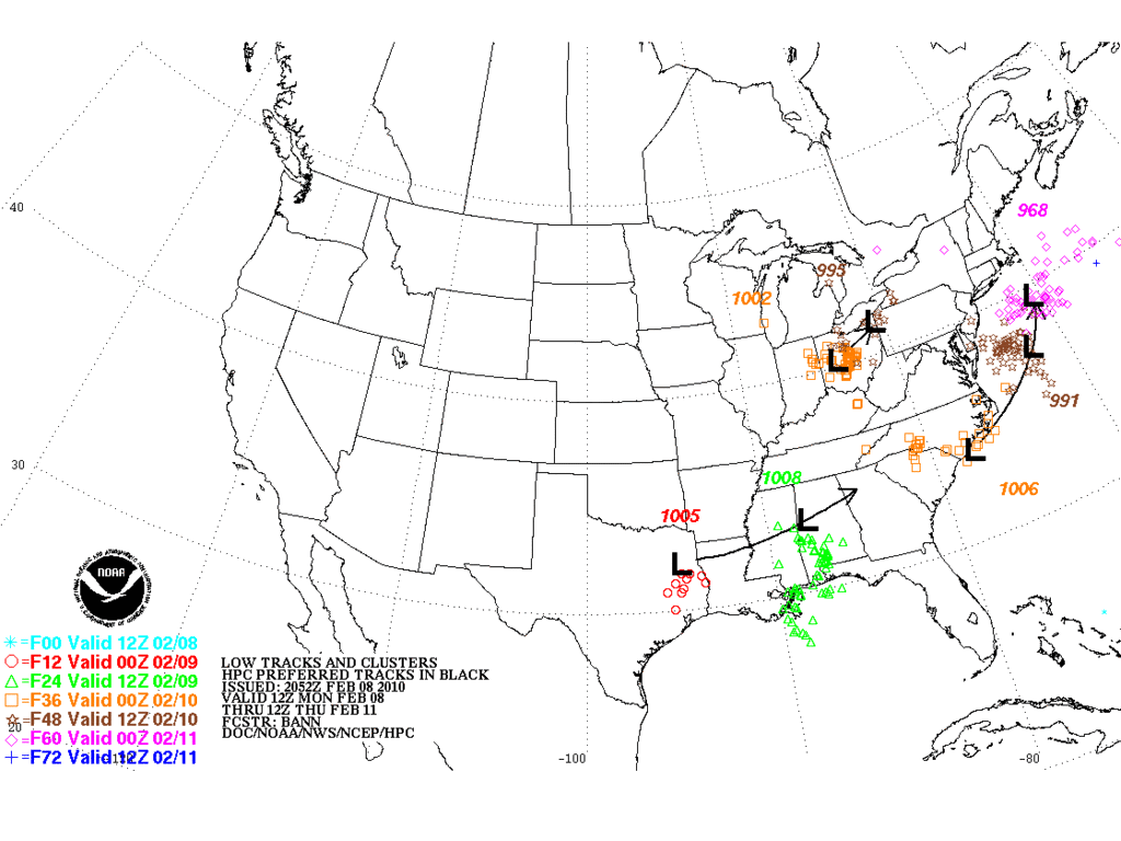
20Z Updated HPC Ensemble Low Tracks...
0 likes
Carla/Alicia/Jerry(In The Eye)/Michelle/Charley/Ivan/Dennis/Katrina/Rita/Wilma/Ike/Harvey
Member: National Weather Association
Wx Infinity Forums
http://wxinfinity.com/index.php
Facebook.com/WeatherInfinity
Twitter @WeatherInfinity
Member: National Weather Association
Wx Infinity Forums
http://wxinfinity.com/index.php
Facebook.com/WeatherInfinity
Twitter @WeatherInfinity
-
TeamPlayersBlue

- Category 5

- Posts: 3533
- Joined: Tue Feb 02, 2010 1:44 am
- Location: Denver/Applewood, CO
I think they are being conservative also. I think the snow line is further south than Waco. The atmosphere will cool rapidly when the precip starts falling. Also, never underestimate how a Low rapidly develops once it enters the proximity of the gulf
0 likes
Personal Forecast Disclaimer:
The posts in this forum are NOT official forecast and should not be used as such. They are just the opinion of the poster and may or may not be backed by sound meteorological data. They are NOT endorsed by any professional institution or storm2k.org. For official information, please refer to the NHC and NWS products.
The posts in this forum are NOT official forecast and should not be used as such. They are just the opinion of the poster and may or may not be backed by sound meteorological data. They are NOT endorsed by any professional institution or storm2k.org. For official information, please refer to the NHC and NWS products.
-
TeamPlayersBlue
- Category 5
- Posts: 3533
- Joined: Tue Feb 02, 2010 1:44 am
- Location: Denver/Applewood, CO
Nacogdoches, ( south of Tyler, just north of Lufkin) Just turnjed their forecast colder for the storm. Snow/sleet wed night into thurs morning, then switching to rain after noon, then back to snow later. Before it was only snow/sleet thurs night
0 likes
Personal Forecast Disclaimer:
The posts in this forum are NOT official forecast and should not be used as such. They are just the opinion of the poster and may or may not be backed by sound meteorological data. They are NOT endorsed by any professional institution or storm2k.org. For official information, please refer to the NHC and NWS products.
The posts in this forum are NOT official forecast and should not be used as such. They are just the opinion of the poster and may or may not be backed by sound meteorological data. They are NOT endorsed by any professional institution or storm2k.org. For official information, please refer to the NHC and NWS products.
-
wxman57
- Moderator-Pro Met
- Posts: 23175
- Age: 68
- Joined: Sat Jun 21, 2003 8:06 pm
- Location: Houston, TX (southwest)
Re: Texas winter wx thread (2009-2010)
TrekkerCC wrote:Thanks to Brent for finding this:
This is from the CPC Hazard Assessment for Feb 11 & 12 -
http://img9.imageshack.us/img9/8679/cpcthreats.png[/url]
I think the center of the heavy snow area will be farther south in Texas, probably along I-20, not up near the Red River and across OK. Not enough moisture up there.
The word is that the DFW office is about to issue a special statement on upcoming winter weather.
0 likes
-
cycloneye

- Admin

- Posts: 149730
- Age: 69
- Joined: Thu Oct 10, 2002 10:54 am
- Location: San Juan, Puerto Rico
Re: Texas winter wx thread (2009-2010)
NWS Fort Worth Special Winter Weather Statement
Here is the special statement from NWS FW about the expected winter weather in the area.
SPECIAL WEATHER STATEMENT
NATIONAL WEATHER SERVICE FORT WORTH TX
330 PM CST MON FEB 8 2010
TXZ091>095-100>107-115>123-129>135-141>148-156>162-174-175-090600-
MONTAGUE-COOKE-GRAYSON-FANNIN-LAMAR-YOUNG-JACK-WISE-DENTON-COLLIN-
HUNT-DELTA-HOPKINS-STEPHENS-PALO PINTO-PARKER-TARRANT-DALLAS-
ROCKWALL-KAUFMAN-VAN ZANDT-RAINS-EASTLAND-ERATH-HOOD-SOMERVELL-
JOHNSON-ELLIS-HENDERSON-COMANCHE-MILLS-HAMILTON-BOSQUE-HILL-
NAVARRO-FREESTONE-ANDERSON-LAMPASAS-CORYELL-BELL-MCLENNAN-FALLS-
LIMESTONE-LEON-MILAM-ROBERTSON-
330 PM CST MON FEB 8 2010
...COLD TONIGHT THEN WINTRY WEATHER EXPECTED ACROSS MUCH OF NORTH
TEXAS EARLY THURSDAY INTO THURSDAY NIGHT...
A STRONG COLD FRONT WILL MOVE THROUGH NORTH TEXAS TONIGHT WITH
NORTH WINDS INCREASING TO 15 TO 25 MPH. ALL OF THE PRECIPITATION
WILL HAVE MOVED EAST OF THE AREA BY THE TIME TEMPERATURES FALL TO
BELOW FREEZING DURING THE OVERNIGHT HOURS. LOW TEMPERATURES WILL
FALL TO BETWEEN 24 AND 29 DEGREES ACROSS MOST OF NORTH TEXAS...SO
ANY RESIDUAL WATER ON AREA ROADS WILL LIKELY FREEZE. PATCHY ICE IS
LIKELY TO FORM DURING THE OVERNIGHT AND EARLY MORNING
HOURS...MAKING ROADS SLICK. WIND CHILLS WILL BE IN THE LOW TEENS
EARLY TUESDAY MORNING.
ANOTHER STORM SYSTEM WILL APPROACH THE AREA BY MIDWEEK WHILE
TEMPERATURES REMAIN COLD ACROSS THE REGION. IT APPEARS AT THIS
TIME THAT SUFFICIENT MOISTURE WILL MOVE NORTHWARD IN ADVANCE OF
THIS SYSTEM FOR SNOWFALL TO OCCUR ACROSS MUCH OF NORTH TEXAS
DURING THE DAY THURSDAY INTO THURSDAY EVENING. WHILE THERE IS
STILL SOME UNCERTAINTY AS TO THE SPEED AND TRACK OF THE EVOLVING
SYSTEM...WHICH COULD SIGNIFICANTLY AFFECT THE THERMAL PROFILE
FAVORABLE FOR SNOW PRODUCTION...OVERALL CONFIDENCE IN THIS STORM
SYSTEM IS INCREASING.
AREAS NORTH OF A KILLEEN TO WACO TO ATHENS LINE APPEAR TO HAVE
THE BEST CHANCE FOR ACCUMULATING SNOWS DURING THE DAY THURSDAY.
TEMPERATURES AT THE SURFACE WILL BE AT OR SLIGHTLY ABOVE FREEZING
AT THE ONSET OF THE EVENT...WHICH MEANS THAT SNOW WILL LIKELY MELT
INITIALLY...THEN ACCUMULATE AS HEAVIER BANDS DEVELOP. AT THIS TIME
IT APPEARS THAT ACCUMULATIONS OF 1 TO 3 INCHES WILL BE POSSIBLE.
UNCERTAINTY IN THE EXACT TRACK AND SPEED OF THIS SYSTEM COULD
SIGNIFICANTLY AFFECT SNOWFALL ACCUMULATION TOTALS.
RESIDENTS OF NORTH TEXAS AND MOTORISTS TRAVELING ACROSS THE
REGION ON THURSDAY SHOULD STAY INFORMED OF THE LATEST WEATHER
INFORMATION AND FORECASTS BY VISITING OUR WEBSITE AT
http://WWW.WEATHER.GOV/FORTWORTH
$$
DUNN
0 likes
Visit the Caribbean-Central America Weather Thread where you can find at first post web cams,radars
and observations from Caribbean basin members Click Here
and observations from Caribbean basin members Click Here
-
TrekkerCC
- S2K Supporter
- Posts: 263
- Joined: Sat Sep 06, 2003 10:19 pm
- Location: North Central Texas (Dallas Area)
Re: Texas winter wx thread (2009-2010)
wxman57 wrote:TrekkerCC wrote:Thanks to Brent for finding this:
This is from the CPC Hazard Assessment for Feb 11 & 12 -
http://img9.imageshack.us/img9/8679/cpcthreats.png[/url]
I think the center of the heavy snow area will be farther south in Texas, probably along I-20, not up near the Red River and across OK. Not enough moisture up there.
The word is that the DFW office is about to issue a special statement on upcoming winter weather.
Do you think DFW office may throw up a Winter Storm Watch on Wednesday? It looks like we might get snowprovided the moisture is as predicted by the models) that we could be within the winter storm criteria for the DFW area.
0 likes
Storm2K Forecast Disclaimer:
This post is NOT AN OFFICIAL FORECAST and should not be used as such. It is just the opinion of the poster and may or may not be backed by sound meteorological data. It is NOT endorsed by any professional institution including storm2k.org. For Official Information please refer to the NHC and NWS products.
This post is NOT AN OFFICIAL FORECAST and should not be used as such. It is just the opinion of the poster and may or may not be backed by sound meteorological data. It is NOT endorsed by any professional institution including storm2k.org. For Official Information please refer to the NHC and NWS products.
-
Weatherdude20
Re: Texas winter wx thread (2009-2010)
I would say as very conservative as the NWS in Fort Worth is, 1-3" is good news 3 days out !
And I execpt way more than that though...
@Trekker DEFINITELY they will... No question... If not higher than that.
And I execpt way more than that though...
@Trekker DEFINITELY they will... No question... If not higher than that.
0 likes
Who is online
Users browsing this forum: No registered users and 117 guests