Texas winter wx thread (2009-2010)

Winter Weather Discussion

Moderator: S2k Moderators

Forum rules

The posts in this forum are NOT official forecast and should not be used as such. They are just the opinion of the poster and may or may not be backed by sound meteorological data. They are NOT endorsed by any professional institution or STORM2K.

Help Support Storm2K
Message
Author
User avatar
southerngale
Retired Staff
Retired Staff
Posts: 27418
Joined: Thu Oct 10, 2002 1:27 am
Location: Southeast Texas (Beaumont area)

Re: Re:

#5661 Postby southerngale » Mon Feb 08, 2010 11:38 pm

Texas Snowman wrote:
HockeyTx82 wrote:I guess the one thing I need to tell myself is the models forecast and don't control the weather. While we look at them for guidance I assume they have been wrong many of time. I think you all have used the word flip-flop many of times......


We need a "popcorn munching" smiley for wobble watching during the 'cane season and model flip-flopping during winter storm season! :D


Image
0 likes   
Please support Storm2k by making a donation today. It is greatly appreciated! Click here: Image

Image my Cowboys Image my RocketsImage my Astros

katheria
Category 1
Category 1
Posts: 338
Joined: Mon Dec 28, 2009 10:51 pm
Location: Garland TX

Re: Re:

#5662 Postby katheria » Mon Feb 08, 2010 11:42 pm

southerngale wrote:
Texas Snowman wrote:
HockeyTx82 wrote:I guess the one thing I need to tell myself is the models forecast and don't control the weather. While we look at them for guidance I assume they have been wrong many of time. I think you all have used the word flip-flop many of times......


We need a "popcorn munching" smiley for wobble watching during the 'cane season and model flip-flopping during winter storm season! :D


Image


woohoooo :notworthy:
0 likes   
just a guess.......take everything i say with a grain of salt.......check your local NWS for forecast information

HockeyTx82
S2K Supporter
S2K Supporter
Posts: 2540
Joined: Tue Oct 27, 2009 11:17 am
Location: Ponder, TX

Re: Texas winter wx thread (2009-2010)

#5663 Postby HockeyTx82 » Tue Feb 09, 2010 12:27 am

Wait and see? Where did everyone go?
0 likes   
Don't hold me accountable for anything I post on this forum. Leave the real forecasting up to the professionals.

Location: Ponder, TX (all observation posts are this location unless otherwise noted)

User avatar
Ntxw
Storm2k Moderator
Storm2k Moderator
Posts: 22789
Joined: Wed Oct 21, 2009 6:34 pm
Location: DFW, Texas

#5664 Postby Ntxw » Tue Feb 09, 2010 2:23 am

0z EC actually tries to keep the low cut off briefly over Texas somewhere west\southwest of the Metro. Wonder if that'll pull moisture up? Looks more north than the GFS and NAM.
0 likes   
The above post and any post by Ntxw is NOT an official forecast and should not be used as such. It is just the opinion of the poster and may or may not be backed by sound meteorological data. It is NOT endorsed by any professional institution including Storm2k. For official information, please refer to NWS products.

  Help support Storm2K!
Help Support Storm2K

User avatar
somethingfunny
ChatStaff
ChatStaff
Posts: 3926
Age: 37
Joined: Thu May 31, 2007 10:30 pm
Location: McKinney, Texas

Re: Texas winter wx thread (2009-2010)

#5665 Postby somethingfunny » Tue Feb 09, 2010 3:25 am

HockeyTx82 wrote:Wait and see? Where did everyone go?


This thread grew by 20 pages since I last checked in! :eek:
0 likes   

User avatar
funster
Category 3
Category 3
Posts: 817
Joined: Sat Dec 29, 2007 4:27 pm
Location: North Dallas

#5666 Postby funster » Tue Feb 09, 2010 5:04 am

Wet snow still in the forecast...

AREA FORECAST DISCUSSION
NATIONAL WEATHER SERVICE FORT WORTH TX
354 AM CST TUE FEB 9 2010

.DISCUSSION...
COLD AIR ADVECTION WILL CONTINUE ACROSS NORTH TEXAS TODAY BEHIND A
COLD FRONT THAT MOVED THROUGH THE REGION MONDAY. THE COLD AIR
ADVECTION WILL BE OFFSET BY SOME HEATING FROM THE SUN AND
AFTERNOON HIGHS SHOULD MANAGE TO WARM INTO THE 40S IN MOST
LOCATIONS. A GUSTY NORTH WIND THIS MORNING SHOULD SLOWLY DECREASE
THIS AFTERNOON AS THE PRESSURE GRADIENT WEAKENS. A LIGHT
WIND...DRY AIR...AND A PARTLY CLOUDY SKY OVERNIGHT WILL ALLOW FOR
GOOD RADIATIONAL COOLING WITH OVERNIGHT LOWS COOLING INTO THE 20S.

MOISTURE WILL BE ON THE INCREASE ACROSS NORTH TEXAS WEDNESDAY AS
THE NEXT LOW PRESSURE SYSTEM STRENGTHENS OVER BAJA. SOME LIGHT
RAIN MAY DEVELOP OVER THE SOUTHWEST ZONES WEDNESDAY AFTERNOON BUT
ANY RAINFALL SHOULD BE LIGHT AS MOISTURE WILL BE MOSTLY ELEVATED.
LOW LEVEL MOISTURE AND LIFT WILL INCREASE WEDNESDAY NIGHT AS THE
LOW PRESSURE SYSTEM APPROACHES FROM THE WEST. THE BIGGEST
CHALLENGE WITH FORECAST WILL BE PRECIPITATION TYPE WEDNESDAY NIGHT
THROUGH THURSDAY NIGHT. 00Z FORECAST SOUNDINGS AND PARTIAL
THICKNESSES INDICATE A RAIN/SNOW MIX FOR MUCH OF THE REGION WITH
SURFACE TEMPERATURES NEAR OR JUST ABOVE FREEZING. PRECIPITATION
CHANCES WILL INCREASE ON THURSDAY AS THE LOW PRESSURE SYSTEM MOVES
ACROSS TEXAS. SURFACE TEMPERATURES WILL REMAIN STEADY OR SLOWLY
WARM WITH WEAK WARM AIR ADVECTION. IT APPEARS THAT SNOW WILL BE
THE PRIMARY PRECIPITATION TYPE OVER ALL BUT THE SOUTHEAST ZONES.
ALTHOUGH THE CHANCES FOR SNOW WILL BE GOOD...THE IMPACTS FROM THE
SNOW MAY NOT BE TOO SIGNIFICANT DUE TO THE WARM SURFACE
TEMPERATURES. WE STILL EXPECT SOME ACCUMULATIONS...GENERALLY LESS
THAN 3 INCHES...OF SLUSHY/WET SNOW ON GRASSY AND ELEVATED
SURFACES. PRECIPITATION CHANCES WILL END FROM WEST TO EAST
THURSDAY NIGHT AS THE UPPER TROUGH AXIS MOVES EAST AND DRIER AIR
MOVES IN AT THE SURFACE. WE ARE CONCERNED THAT SOME TRAVEL IMPACTS
COULD DEVELOP THURSDAY NIGHT AS RESIDUAL MOISTURE FREEZES...
ESPECIALLY ON ELEVATED SURFACES. FOR NOW WE WILL NOT ISSUE ANY
TYPE OF WINTER WEATHER WATCH DUE TO THE WARM SURFACE TEMPERATURES
EXPECTED. HOWEVER...LATER SHIFTS MAY NEED TO ISSUE A WATCH IF NEW
MODEL DATA SUGGESTS COLDER SURFACE TEMPERATURES.

THE WEEKEND SHOULD BE DRY AND SLIGHTLY WARMER WITH BRIEF RIDGING
ALOFT AND SOME SUN. SOME SLIGHT RAIN CHANCES WILL RETURN TO THE
FORECAST SUNDAY WHEN A SHORT WAVE TROUGH AND COLD FRONT MOVE
ACROSS THE REGION. FOR NOW WE WILL KEEP PRECIP AS ALL RAIN AND END
THE PRECIP BEFORE THE COLD AIR ARRIVES SUNDAY NIGHT.
0 likes   

User avatar
Portastorm
Storm2k Moderator
Storm2k Moderator
Posts: 9914
Age: 63
Joined: Fri Jul 11, 2003 9:16 am
Location: Round Rock, TX
Contact:

Re: Texas winter wx thread (2009-2010)

#5667 Postby Portastorm » Tue Feb 09, 2010 7:13 am

Interesting to see the 0z GFS trend further south with the upper-level trough. Looks like it means warmer for us (AUS area) too although the end game of the upper system passing overhead may bring a little "excitement." NWSFO EWX expounds further:

A MIX OF WINTER PRECIPIATION REMAINS A GOOD POSSIBILITY OVER MUCH
OF SOUTH CENTRAL TEXAS OVER THE NEXT FEW DAYS.
LIGHT ELEVATED
FLURRIES ARE BEING DETECTED BY RADAR THIS MORNING...BUT DRY LOW
LEVEL CONDITIONS SHOULD EVAPORATE THE MOISTURE BEFORE IT REACHES
THE SURFACE...AND MODELS SHOW THE EARLY MORNING LIFTING MECHANISM
TO WEAKEN WITH TIME.

MORNING LOW CLOUDS AND STRONG NORTH WINDS OF 15-25 MPH EARLY WILL
HOLD MOST HIGH TEMPS IN THE 40S TO SET UP A COLD NIGHT TONIGHT.
CLOUDS AND ISENTROPIC LIFT INCREASES BACK OVER THE AREA FROM THE
WEST TONIGHT...PREVENTING A HARD FREEZE OVER MANY AREAS WITH THE
BEST CHANCE OF A HARD FREEZE OVER NE COUNTIES. LIGHT PRECIPITATION
IS EXPECTED TO DEVELOP TOWARD DAYBREAK NEAR THE RIO GRANDE...AND
SPREAD EAST ACROSS MUCH OF SOUTH CENTRAL TX DURING THE DAY
WEDNESDAY. MODEL SOUNDINGS SUGGEST EARLY WEDNESDAY TO BE THE
PERIOD WHEN MIXED PRECIP CAN BE SEEN FARTHEST SOUTH...BUT RATES
ARE EXPECTED TO BE TOO LIGHT TO AMOUNT TO ACCUMULATION UNTIL
TEMPERATURES MODIFY LOW LEVELS TO PROMOTE A CHANGE BACK TO MAINLY
RAIN. HIGHER ELEVATIONS OVER NORTHWEST COUNTIES COULD SEE ENOUGH
LOW LEVEL TEMPERATURE MODIFICATION FROM THE EARLY PRECIPIATION TO
PROMOTE A CONTINUED MIX INTO WEDNESDAY NIGHT AND THURSDAY...BUT
LIGHT RATES AND WARMER SURFACE CONDITIONS ARE STILL EXPECTED TO
PREVENT ANY SIGNIFICANT ACCUMULATION OF ICE. MODEL TRENDS HAVE
SHOWN THE STORM TRACK GOING INCREASINGLY FARTHER SOUTH WITH
SUCCESSIVE RUNS...SUGGESTING A BETTER OPPORTUNITY TO KEEP LOW
LEVEL TEMPERATURES ABOVE FREEZING WITH NEAR 100 PERCENT HUMIDITIES
THROUGH SEVERAL THOUSAND FEET THROUGH THURSDAY EVENING
.

THE BEST CHANCE FOR MEASURABLE WINTER PRECIPITATION IS EXPECTED
TO OCCUR LATE THURSDAY NIGHT
AS THE UPPER LOW CENTER OPENS UP AS A
TROUGH AND SLIDES EAST TO SOUTHEAST ACROSS THE AREA. BY MIDNIGHT
FRIDAY MORNING...MODELS SHOW THE COLDER AIR ALOFT DESCENDING
TOWARD THE SURFACE WITH RAIN LIKELY CHANGING OVER TO SNOW FOR
AREAS GENERALLY ALONG AND NORTH OF THE BALCONES ESCARPMENT. THE
GFS FORECAST OPENING OF THE LOW INTO AN OPEN WAVE ALOFT SUGGESTS
PRECIPITATION RATES WOULD ONLY SUPPORT SNOW ACCUMULATIONS OF
AROUND AN INCH AT BEST FOR PARTS OF THE HILL COUNTRY.
HOWEVER...THE NAM MODEL CONTINUES A MORE COMPACT SYSTEM THAT COULD
SUGGEST MORE SNOW AND A DURATION LINGERING INTO THE LATE MORNING
HOURS FRIDAY
. WITH A SHORT PERIOD OF OPPORTUNITY TO ACCUMULATE
SNOW AND A WEAKENING STORM SYSTEM...WILL ANTICIPATE A LOWER IMPACT
WINTER WX EVENT AND CONTINUE ADDRESSING THE THREAT WITH AN SPS FOR
ANOTHER SHIFT.

MODEL RUNS FOR LATER PERIODS CONTINUE TO TREND COLDER FOR THE
WEEKEND...BUT CONENSUS ALSO IS TRENDING DRIER WITH LESS
SUBTROPICAL JET ACTIVITY.
0 likes   

User avatar
Ntxw
Storm2k Moderator
Storm2k Moderator
Posts: 22789
Joined: Wed Oct 21, 2009 6:34 pm
Location: DFW, Texas

#5668 Postby Ntxw » Tue Feb 09, 2010 7:29 am

I still have hope for this storm since the Canadian and EC are further north with the track. Yesterday was about as depressing as model watching could go lol. GFS was spoiling us with big numbers and now brought us back to earth with a more realistic typical wet 1-3 inches of slush.
0 likes   
The above post and any post by Ntxw is NOT an official forecast and should not be used as such. It is just the opinion of the poster and may or may not be backed by sound meteorological data. It is NOT endorsed by any professional institution including Storm2k. For official information, please refer to NWS products.


  Help support Storm2K!

Help Support Storm2K


User avatar
Portastorm
Storm2k Moderator
Storm2k Moderator
Posts: 9914
Age: 63
Joined: Fri Jul 11, 2003 9:16 am
Location: Round Rock, TX
Contact:

Re:

#5669 Postby Portastorm » Tue Feb 09, 2010 7:34 am

Ntxw wrote:I still have hope for this storm since the Canadian and EC are further north with the track. Yesterday was about as depressing as model watching could go lol. GFS was spoiling us with big numbers and now brought us back to earth with a more realistic typical wet 1-3 inches of slush.


Agreed. It's just one model run. If we see more of that trend in the 12z runs, then it may be time to temper expectations. Taking a look at satellite, the upper-level system is just now only digging off the California coast.

http://www.meteo.psu.edu/~gadomski/SAT_WEST/anim8ir.html
0 likes   

User avatar
srainhoutx
S2K Supporter
S2K Supporter
Posts: 6919
Age: 67
Joined: Sun Jan 14, 2007 11:34 am
Location: Haywood County, NC
Contact:

Re: Texas winter wx thread (2009-2010)

#5670 Postby srainhoutx » Tue Feb 09, 2010 8:00 am

Some nuggets in the HPC Prelim Extended Dsico...

PRELIMINARY EXTENDED FORECAST DISCUSSION
NWS HYDROMETEOROLOGICAL PREDICTION CENTER CAMP SPRINGS MD
235 AM EST TUE FEB 09 2010

VALID 12Z SAT FEB 13 2010 - 12Z TUE FEB 16 2010

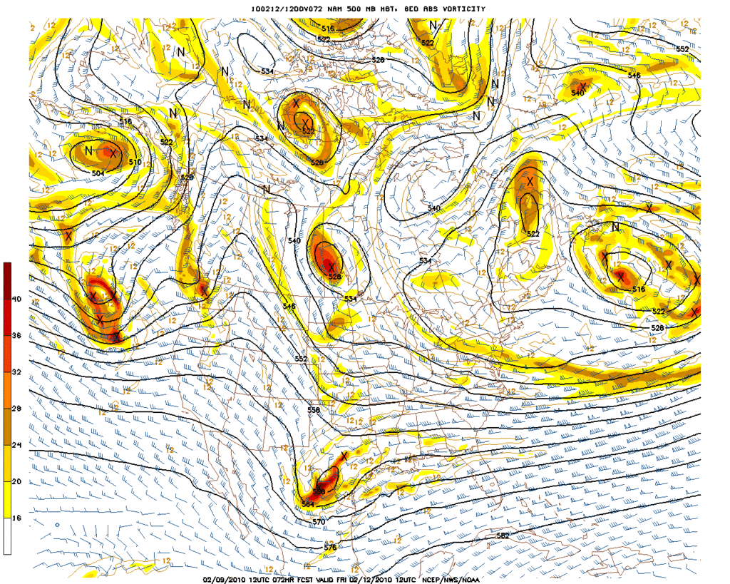
MODELS MAINTAIN RELATIVELY GOOD LARGE-SCALE CONTINUITY WITH PRIOR
RUNS IN DEPICTING SLOWLY MODULATING UPPER LOWS OVER ALASKA/NE
PACIFIC AND THE CANADIAN MARITIMES/NEW ENGLAND...WITH A
COMPLICATED SERIES OF SMALLER WAVELENGTH UPPER LOWS/UPPER HIGHS
CAUGHT IN BETWEEN. THE RESULTING LONGWAVE FLOW ACROSS THE HIGHER
LATITUDES HELPS TO PERPETUATE A SPLIT-FLOW REGIME OVER THE CONUS.
HOWEVER...MODELS CONTINUE TO SHOW CONSIDERABLE VARIABILITY WITH
THE DAY-TO-DAY DETAILS...INCLUDING POTENTIAL INTERACTIONS BETWEEN
THE NORTHERN AND SOUTHERN STREAMS. GENERALLY SPEAKING...SUCH A
PATTERN REMAINS FAVORABLE FOR PERIODIC ARRIVAL OF SIGNIFICANT
SHORTWAVE TROUGH ALONG THE WEST COAST...WHICH THEN SPLIT...WITH
THE SOUTHERN STREAM BECOMING DOMINANT. HOWEVER...ONE NOTABLE
CHANGES OBSERVED THIS CYCLE IS FOR A MORE SIGNIFICANT PORTION OF
THE COMPLICATED UPPER LOW OVER MANITOBA DAY 3 TO DROP SOUTHWARD
AND ROTATE THROUGH THE BASE OF THE RETROGRADING UPPER LOW TO ITS
NORTH...RESULTING IN A SIGNIFICANT SURGE OF ARCTIC AIR COMING
STRAIGHT OUT OF NORTH CENTRAL CANADA.
THE ECWMF LIES ON THE FAST
SIDE OF THE GUIDANCE WITH THIS PARTICULAR SYSTEM...WITH GOOD PHASE
AGREEMENT SEEN AMONG THE GFS/CANADIAN/UKMET FOR SLOWER TIMING.
OTHERWISE...THE PRELIMINARY PRESSURES/FRONTS STARTED WITH A 70/30
GFS/GEFS MEAN BLEND DAYS 3-4...AND A 50/50 GFS/GEFS MEAN BLEND
DAYS 5-7.

JAMES

I also strongly suggest that folks check out the When Will We See The Arctic Air Return thread. From a purely historical point of patterns and Long Range forecasting, there s a wealth of knowledge being shared and what may very well become a new Winter Benchmark is unfolding right before our eyes IMHO. :wink:
0 likes   
Carla/Alicia/Jerry(In The Eye)/Michelle/Charley/Ivan/Dennis/Katrina/Rita/Wilma/Ike/Harvey

Member: National Weather Association
Wx Infinity Forums
http://wxinfinity.com/index.php

Facebook.com/WeatherInfinity
Twitter @WeatherInfinity

User avatar
wxman57
Moderator-Pro Met
Moderator-Pro Met
Posts: 22984
Age: 67
Joined: Sat Jun 21, 2003 8:06 pm
Location: Houston, TX (southwest)

Re: Texas winter wx thread (2009-2010)

#5671 Postby wxman57 » Tue Feb 09, 2010 8:36 am

I'm plotting upper-air forecast soundings for all across TX (Dallas/Austin/Houston) and they all look about the same for Thursday. The temperature line just HUGS the 0C isotherm from the surface to 10,000 ft (a tad warmer here in Houston). That makes for a very difficult forecast of snow accumulations (which is typically a hard enough task). As I had suspected the GFS was overdoing the precip well inland across NE TX. West Gulf lows produce heaviest precip closer to the coast. But it sill looks like the DFW area is setting up for at least several inches of snow, possibly as much as 3-5". Austin area is more questionable. I think you'll see SOME frozen precip, but it could be anywhere from a few sleet pellets to an inch or more of snow. For Houston, looks like cold rain with maybe a few sleet pellets.
0 likes   

User avatar
txagwxman
Professional-Met
Professional-Met
Posts: 960
Joined: Thu Dec 24, 2009 3:26 pm
Location: Tomball, TX

#5672 Postby txagwxman » Tue Feb 09, 2010 8:41 am

Well ECWMF/UKMET/GEM are the deepest and coolest, while the POJ GFS is not as cold and keeps flipping back and forth. Leaning with the ECMWF/UKMET solution for now. Get ready for some snow (DFW/ACT/AUS, maybe CLL/UTS if the ECMWF right for Fri morning).
Houston is a cold rain---bummer. :froze: If ECMWF right there could be several inches in CLL/ACT/TPL/CRS Friday morning. Still early in the forecast but should be fun to watch this set - up. And agree with WXMAN57 precip going to be heaviest SE.
Last edited by txagwxman on Tue Feb 09, 2010 8:54 am, edited 1 time in total.
0 likes   
“If you thought that science was certain - well, that is just an error on your part.”

serenata09
Tropical Storm
Tropical Storm
Posts: 166
Joined: Fri Jan 18, 2008 7:55 pm
Location: Dallas, TX

Re: Texas winter wx thread (2009-2010)

#5673 Postby serenata09 » Tue Feb 09, 2010 8:53 am

I will be in San Antonio starting on Wednesday and will miss yet another DFW snow event. What are the chances looking like for SAT?
0 likes   

Weatherdude20

Re: Texas winter wx thread (2009-2010)

#5674 Postby Weatherdude20 » Tue Feb 09, 2010 9:06 am

Its currently 26.3
0 likes   

User avatar
srainhoutx
S2K Supporter
S2K Supporter
Posts: 6919
Age: 67
Joined: Sun Jan 14, 2007 11:34 am
Location: Haywood County, NC
Contact:

Re: Texas winter wx thread (2009-2010)

#5675 Postby srainhoutx » Tue Feb 09, 2010 9:07 am

Thanks for the update txagwxman. Maybe the ECMWF will in fact score a coupe and the Upper Low will track just close enough to give those of us in the N and NW burbs of Houston our chance to see some wintry precip. With that said, the pattern does look ripe for future events in the next couple of weeks IMHO.
0 likes   
Carla/Alicia/Jerry(In The Eye)/Michelle/Charley/Ivan/Dennis/Katrina/Rita/Wilma/Ike/Harvey

Member: National Weather Association
Wx Infinity Forums
http://wxinfinity.com/index.php

Facebook.com/WeatherInfinity
Twitter @WeatherInfinity

User avatar
TrekkerCC
S2K Supporter
S2K Supporter
Posts: 263
Joined: Sat Sep 06, 2003 10:19 pm
Location: North Central Texas (Dallas Area)

Re: Texas winter wx thread (2009-2010)

#5676 Postby TrekkerCC » Tue Feb 09, 2010 9:18 am

I want to address this question to our two Texas pro-mets (txagwxman and wxman57) about the upcoming winter weather event. What struck me is the reference last night from the Dallas/Ft. Worth office to the December 29, 2009 event.

Here is the relevant snippet.

Ft. Worth NWS Office wrote:MAIN CONCERN IN THE FORECAST IS THE WINTER POTENTIAL THURSDAY. THIS PATTERN IS VERY SIMILAR TO THE DEC 29 SNOW EVENT EARLIER THIS WINTER...WHERE A SLUSHY 1-2 INCHES OF SNOW FELL ACROSS THE NORTH WITH TEMPS NEAR OR ABOVE FREEZING.


From my recollection, the December 29th event was a much more marginal event in the DFW area than the predictions for this coming event. There was a lengthy transition period before it started snowing, and it appears like the transition period will not be quite as long with this event, and it just seems like the cold dome might not erode quite as quickly as was the case on December 29th. It just seems like the conditions might work out better (or worse - depending if you like snow) in this event than the previous event. Maybe I'm just looking through rosy-colored sunglasses right now.
0 likes   
Storm2K Forecast Disclaimer:

This post is NOT AN OFFICIAL FORECAST and should not be used as such. It is just the opinion of the poster and may or may not be backed by sound meteorological data. It is NOT endorsed by any professional institution including storm2k.org. For Official Information please refer to the NHC and NWS products.

User avatar
txagwxman
Professional-Met
Professional-Met
Posts: 960
Joined: Thu Dec 24, 2009 3:26 pm
Location: Tomball, TX

Re: Texas winter wx thread (2009-2010)

#5677 Postby txagwxman » Tue Feb 09, 2010 9:45 am

srainhoutx wrote:Thanks for the update txagwxman. Maybe the ECMWF will in fact score a coupe and the Upper Low will track just close enough to give those of us in the N and NW burbs of Houston our chance to see some wintry precip. With that said, the pattern does look ripe for future events in the next couple of weeks IMHO.

This winter appear to be far from over...but getting a little late for snow in Houston.
0 likes   
“If you thought that science was certain - well, that is just an error on your part.”

User avatar
srainhoutx
S2K Supporter
S2K Supporter
Posts: 6919
Age: 67
Joined: Sun Jan 14, 2007 11:34 am
Location: Haywood County, NC
Contact:

Re: Texas winter wx thread (2009-2010)

#5678 Postby srainhoutx » Tue Feb 09, 2010 9:49 am

txagwxman wrote:
srainhoutx wrote:Thanks for the update txagwxman. Maybe the ECMWF will in fact score a coupe and the Upper Low will track just close enough to give those of us in the N and NW burbs of Houston our chance to see some wintry precip. With that said, the pattern does look ripe for future events in the next couple of weeks IMHO.

This winter appear to be far from over...but getting a little late for snow in Houston.


Thanks for the response. FWIW the 12Z NAM (hour 72) is yet again further S and a tad stronger with the H5 feature...

Image
0 likes   
Carla/Alicia/Jerry(In The Eye)/Michelle/Charley/Ivan/Dennis/Katrina/Rita/Wilma/Ike/Harvey

Member: National Weather Association
Wx Infinity Forums
http://wxinfinity.com/index.php

Facebook.com/WeatherInfinity
Twitter @WeatherInfinity

User avatar
wxman57
Moderator-Pro Met
Moderator-Pro Met
Posts: 22984
Age: 67
Joined: Sat Jun 21, 2003 8:06 pm
Location: Houston, TX (southwest)

Re: Texas winter wx thread (2009-2010)

#5679 Postby wxman57 » Tue Feb 09, 2010 9:55 am

txagwxman wrote:
srainhoutx wrote:Thanks for the update txagwxman. Maybe the ECMWF will in fact score a coupe and the Upper Low will track just close enough to give those of us in the N and NW burbs of Houston our chance to see some wintry precip. With that said, the pattern does look ripe for future events in the next couple of weeks IMHO.

This winter appear to be far from over...but getting a little late for snow in Houston.


Houston's greatest snowfalls have occurred in mid February, though that appears unlikely this weekend.
0 likes   

User avatar
txagwxman
Professional-Met
Professional-Met
Posts: 960
Joined: Thu Dec 24, 2009 3:26 pm
Location: Tomball, TX

#5680 Postby txagwxman » Tue Feb 09, 2010 9:57 am

Latest NAM is cold enough snow CLL for Fri morning (soundings)...Houston all rain. Still a lot of disagreements, NAM much slower vs the GEM/ECMWF.
0 likes   
“If you thought that science was certain - well, that is just an error on your part.”


Return to “Winter Weather”

Who is online

Users browsing this forum: No registered users and 5 guests