Texas winter wx thread (2009-2010)
Moderator: S2k Moderators
Forum rules
 The posts in this forum are NOT official forecast and should not be used as such. They are just the opinion of the poster and may or may not be backed by sound meteorological data. They are NOT endorsed by any professional institution or STORM2K.

The posts in this forum are NOT official forecast and should not be used as such. They are just the opinion of the poster and may or may not be backed by sound meteorological data. They are NOT endorsed by any professional institution or STORM2K.

Re: Texas winter wx thread (2009-2010)
This is one of the most challenging forecasts since I have been here. The flip flop of the GFS today is making me think it is out to lunch. The NAM is still showing the possibility of a significant snow across the I-20 corridor. The only problem is the warm nose around the 850mb level. If you look at the SREF you will the the ensembles show the 850md 0C line remains south of an Athens to Jacksonville to Carthage line. This would make the precip across the I-20 corridor to remain snow. Based on the QPF we are looking at 1 to 3 inches. Also, models have had a hard time handling surface temps with precip the last two event. Both times here in Tyler we were 5 to 10 degrees colder than progged. So hope is not dead for all the snow lovers. This will be a learning event for all involved and very fun to watch.
0 likes
W. Grant Dade
Good Morning East Texas/Midday Meteorologist
KLTV 7 Tyler, TX
Good Morning East Texas/Midday Meteorologist
KLTV 7 Tyler, TX
-
orangeblood
- S2K Supporter

- Posts: 3895
- Joined: Tue Dec 15, 2009 6:14 pm
- Location: Fort Worth, TX
Re: Texas winter wx thread (2009-2010)
For the Fort Worth NWS to not even put up a SPS, to mention the possibility, is inexcusable as well as only using the American models to base a forecast on. I mean everyone around here preaches to not base your forecast on one model but to use them all as tools. The public at least needs to be put on alert of the possibility with a Special Weather Statement of some sort. Even the graphic displaying the upcoming winter weather event was taken off.
Last edited by orangeblood on Tue Feb 09, 2010 9:12 pm, edited 1 time in total.
0 likes
-
msstateguy83
-
srainhoutx

- S2K Supporter
- Posts: 6919
- Age: 68
- Joined: Sun Jan 14, 2007 11:34 am
- Location: Haywood County, NC
- Contact:
Re: Texas winter wx thread (2009-2010)
Last Update: Wed Feb 10 02:10:01 2010 GMT
NWS TOC Operational Status Message
No current message
NCEP Operational Status Message
Wed Feb 10 01:38:23 2010 GMT
NOUS42 KWNO 100136
ADMNFD
SENIOR DUTY METEOROLOGIST NWS ADMINISTRATIVE MESSAGE
NWS NCEP CENTRAL OPERATIONS CAMP SPRINGS MD
830 PM EST TUES FEB 09 2010
THE 00Z NAM STARTED ON TIME.
RAOBS...
PASY/70414 - NOT AVBL FOR NAM
YEV/71957 - SHORT
KPP/78970 - 10159
YMW/71722 - NO TTAA OR TTBB GROUPS
A Regional Critical Weather Day..CWD..CONTS TIL 11/12Z
..7AM EST..Thursday.
$$
KNEAS/SDM/NCO/NCEP
http://weather.noaa.gov/tgstatus/
Nesdis...
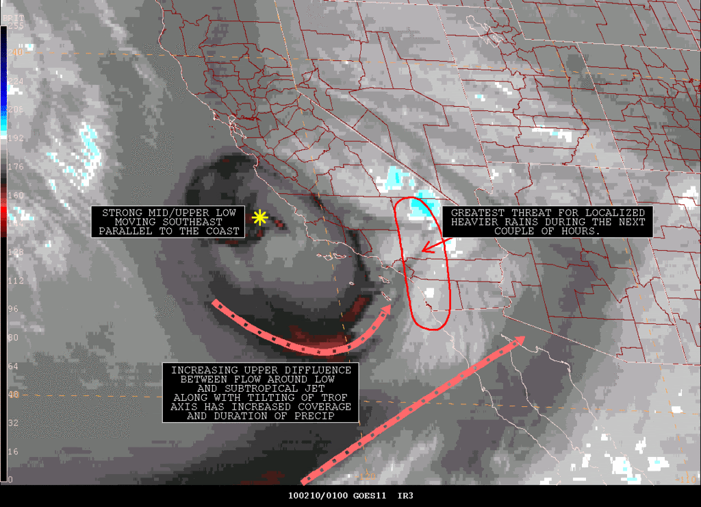
SATELLITE PRECIPITATION ESTIMATES..DATE/TIME 02/10/10 0107Z
SATELLITE ANALYSIS BRANCH/NESDIS---NPPU---TEL.301-763-8678
LATEST DATA USED: GOES-WEST:0045Z JS
.
LOCATION...SOUTHERN CALIFORNIA...
.
ATTN WFOS...PSR...VEF...SGX...HNX...LOX...
ATTN RFCS...CNRFC...
.
EVENT...BAND OF SHOWERS WITH EMBEDDED HEAVIER CONVECTION CONTINUES TO
SLOWLY PROGRESS SOUTHEASTWARD ACROSS S CA.
.
SATELLITE ANALYSIS AND TRENDS...SATELLITE TRENDS CONTINUE TO FOLLOW
ALONG FROM PREVIOUS SPENES MESSAGE. THE WELL DEFINED COMPACT LOW IS
MAKING STEADY SOUTHEASTWARD PROGRESS JUST OFFSHORE AND PARALLEL TO THE
CA COAST. AHEAD OF THIS FEATURE, A BAND OF SHOWERS WITH EMBEDDED HEAVIER
CONVECTIVE CELLS HAS INCREASED SLIGHTLY IN COVERAGE AND INTENSITY OVER
THE PAST COUPLE OF HOURS, PARTLY IN RESPONSE TO SUBTROPICAL JET STREAK
MOVING THROUGH THE BASE OF THE TROF WHICH HAS INCREASED THE OVERALL
UPPER DIFFLUENCE. THE MOST RECENT IR/VIS IMAGES ALONG WITH COMPOSITE
RADAR REFLECTIVITY DATA INDICATE THE MOST ACTIVE PORTION OF THE BAND
EXTENDS FROM ORANGE COUNTY NORTHWARD ACROSS THE WESTERN HALF OF SAN
BERNARDINO COUNTY AND INTO EXTREME SOUTHERN INYO COUNTY WITH A FEW
LIGHTNING STRIKES NOTED ALONG THIS AXIS. THE ACTIVITY IS JUST BEGINNING
TO ALSO MOVE INTO WESTERN RIVERSIDE AND WESTERN SAN DIEGO COUNTIES. LATE
AFTERNOON AREAL AVERAGE MICROWAVE DATA FROM AMSU AND AMSRE INDICATE RAIN
RATES BETWEEN .15"-.30"/HR. BASED ON AVAILABLE MOISTURE(.8" PW VALUES),
CLOUD TOP ENHANCEMENT, AND THE DYNAMICS WITH THE SYSTEM, STILL BELIEVE
LOCALIZED RAIN RATES SHOULD EASILY EXCEED .50"/HR TO POSSIBLY BRIEFLY UP
TO NEAR 1"/HR WITH THE STRONGEST ACTIVITY. AS OF 0045Z, THE BEST SATELLITE
ENHANCEMENT WAS WITH A BATCH MOVING NORTHWARD ACROSS ORANGE/FAR SE LOS
ANGELES/SW SAN BERNARDINO COUNTIES AS WELL AS OVER N CENT SAN BERNARDINO
COUNTY. BELIEVE LOCALIZED RAIN RATES COULD BE IN THE .50"-1.0"/HR RANGE
IN THESE AREAS.
.
SATELLITE EXTRAPOLATION SHOWS THE BACK EDGE OF THE BAND IS MOVING STEADILY
TO THE SE AT AROUND 15-20KTS. HOWEVER, THERE HAS BEEN SOME PIVOTING OF
THE BAND FARTHER INLAND WHICH COULD POSSIBLY TRANSLATE INTO AN INCREASE
IN OVERALL RAIN TOTALS IN APPROXIMATE AREA INCLUDING EXTREME SE LOS
ANGELES/ORANGE/W TO CENT RIVERSIDE/W TO CENT SAN BERNARDINO/W SAN DIEGO
COUNTIES DURING THE NEXT COUPLE OF HOURS.
.
AN ANNOTATED SATELLITE GRAPHIC SHOWING GREATEST HEAVY RAIN THREAT AREA
SHOULD BE AVAILABLE ON THE INTERNET ADDRESS LISTED BELOW IN APPROXIMATELY
10 MINUTES.
.
SEE NCEP HPC DISCUSSION AND QPF/S FOR FORECAST.
....NESDIS IS A MEMBER OF 12 PLANET....
.
SSD/SAB WEB ADDRESS FOR PRECIP ESTIMATES:
HTTP://WWW.SSD.NOAA.GOV/PS/PCPN/
...ALL LOWER CASE EXCEPT /PS/PCPN/
0 likes
Carla/Alicia/Jerry(In The Eye)/Michelle/Charley/Ivan/Dennis/Katrina/Rita/Wilma/Ike/Harvey
Member: National Weather Association
Wx Infinity Forums
http://wxinfinity.com/index.php
Facebook.com/WeatherInfinity
Twitter @WeatherInfinity
Member: National Weather Association
Wx Infinity Forums
http://wxinfinity.com/index.php
Facebook.com/WeatherInfinity
Twitter @WeatherInfinity
-
HockeyTx82
- S2K Supporter
- Posts: 2814
- Joined: Tue Oct 27, 2009 11:17 am
- Location: Ponder, TX
Re: Texas winter wx thread (2009-2010)
Ok, so looks like lots has happened since I last looked around lunch time. I am still holding on to hope. Any new data coming out?
0 likes
Don't hold me accountable for anything I post on this forum. Leave the real forecasting up to the professionals.
Location: Ponder, TX (all observation posts are this location unless otherwise noted)
Location: Ponder, TX (all observation posts are this location unless otherwise noted)


Re: Texas winter wx thread (2009-2010)
HockeyTx82 wrote:Ok, so looks like lots has happened since I last looked around lunch time. I am still holding on to hope. Any new data coming out?
Nam is running and looks much wetter for North Texas (Good trend if you like more snow). It's holding that this storm is stronger than the models have presented which was the belief of many meteorologists. Only one run. Lets see if the rest follows.
0 likes
The above post and any post by Ntxw is NOT an official forecast and should not be used as such. It is just the opinion of the poster and may or may not be backed by sound meteorological data. It is NOT endorsed by any professional institution including Storm2k. For official information, please refer to NWS products.
Help support Storm2K!

Re: Texas winter wx thread (2009-2010)
sits back and eats popcorn cant find popcorn smiley 
0 likes
just a guess.......take everything i say with a grain of salt.......check your local NWS for forecast information

Actually the NAM is looking faster now and more in-line with the GFS. Snow stays north of Austin/CLL on this run. 850 mb 0C line is near Waco north, and less precip in N. TX (although I might be blind). Too bad there is no upper-air cold air advection behind this short-wave, otherwise it would dig deeper and become stronger...
See what happens with the other models.

See what happens with the other models.
Last edited by txagwxman on Tue Feb 09, 2010 9:37 pm, edited 3 times in total.
0 likes
“If you thought that science was certain - well, that is just an error on your part.”
Re:
txagwxman wrote:Actually the NAM is looking faster now and more in-line with the GFS. Snow stays north of Austin/CLL on this run. 850 mb 0C line is near Waco north, and less precip in N. TX.
See what happens with the other models.
Really? I see more precip, maybe i'm just seeing things.
Both at 54hr
0z

Previous 18z

12z had even less. 12z has the system more opened up vs closed so the precip shielf spreads out more. Lets hope the trend continues.
Last edited by Ntxw on Tue Feb 09, 2010 9:36 pm, edited 2 times in total.
0 likes
The above post and any post by Ntxw is NOT an official forecast and should not be used as such. It is just the opinion of the poster and may or may not be backed by sound meteorological data. It is NOT endorsed by any professional institution including Storm2k. For official information, please refer to NWS products.
Help support Storm2K!
Help support Storm2K!
-
orangeblood
- S2K Supporter
- Posts: 3895
- Joined: Tue Dec 15, 2009 6:14 pm
- Location: Fort Worth, TX
Re: Texas winter wx thread (2009-2010)
Much more precip in North Texas compared to the past few NAM runs.
0 likes


Re: Re:
Ntxw wrote:txagwxman wrote:Actually the NAM is looking faster now and more in-line with the GFS. Snow stays north of Austin/CLL on this run. 850 mb 0C line is near Waco north, and less precip in N. TX.
See what happens with the other models.
Really? I see more precip, maybe i'm just seeing things.
Both at 54hr
0z
Previous 18z
I think that would be because the 0z is 6 hours ahead of the 18z, so by the time the 0z gets to 54 hours it includes 6 more hours of precip. i could be wrong. compare 60 hrs from the 18z and 54 hrs from the 0z
0 likes
"It is better to live one day as a lion than a hundred years as a sheep"
0 likes
The above post and any post by Ntxw is NOT an official forecast and should not be used as such. It is just the opinion of the poster and may or may not be backed by sound meteorological data. It is NOT endorsed by any professional institution including Storm2k. For official information, please refer to NWS products.
Help support Storm2K!
Help support Storm2K!
Re: Texas winter wx thread (2009-2010)
18z 60 hours. same time as 54 hrs on the 0z.

close
close
0 likes
"It is better to live one day as a lion than a hundred years as a sheep"
-
zaqxsw75050

- Tropical Storm

- Posts: 178
- Joined: Thu Mar 06, 2008 4:21 pm
- Location: Hong Kong
Re: Texas winter wx thread (2009-2010)
RNGR wrote:18z 60 hours. same time as 54 hrs on the 0z.
close
Not for DFW area.
0 likes
Re: Texas winter wx thread (2009-2010)
I haven't seen the soundings yet but the 0Z NAM has a better chance of snow along I-20. I can't wait up for BUFKIT, but it is looking better in my first impression.
0 likes
W. Grant Dade
Good Morning East Texas/Midday Meteorologist
KLTV 7 Tyler, TX
Good Morning East Texas/Midday Meteorologist
KLTV 7 Tyler, TX
I don't think temps will be too big of an issue north of I-20 either. South of there is very close. Should temps be a few degrees colder than progged, then we're in for good business.
0 likes
The above post and any post by Ntxw is NOT an official forecast and should not be used as such. It is just the opinion of the poster and may or may not be backed by sound meteorological data. It is NOT endorsed by any professional institution including Storm2k. For official information, please refer to NWS products.
Help support Storm2K!
Help support Storm2K!
Who is online
Users browsing this forum: No registered users and 78 guests