Stratton23 wrote:18z Euro came in aggressive, thats definitely a winter storm
Trending back towards its originally solution it had for several days…here are the Kuchera rations, may be a little higher

Moderator: S2k Moderators
 The posts in this forum are NOT official forecast and should not be used as such. They are just the opinion of the poster and may or may not be backed by sound meteorological data. They are NOT endorsed by any professional institution or STORM2K.

Stratton23 wrote:18z Euro came in aggressive, thats definitely a winter storm

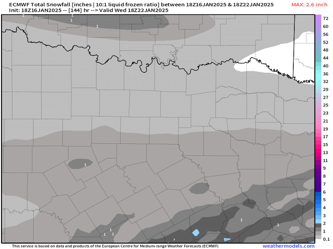
Ivanhater wrote:What is the 18z euro further down the Gulf coast?


orangeblood wrote:Ivanhater wrote:What is the 18z euro further down the Gulf coast?
https://images.weatherbell.com/model/ecmwf-deterministic/se/total_snow_kuchera/1737050400/1737568800-DFTNk9Ag8go.png
orangeblood wrote:Stratton23 wrote:18z Euro came in aggressive, thats definitely a winter storm
Trending back towards its originally solution it had for several days…here are the Kuchera rations, may be a little higher
https://images.weatherbell.com/model/ecmwf-deterministic/tx/total_snow_kuchera/1737050400/1737568800-3FToNVz1JqQ.png


TheAustinMan wrote:A little comparison with the last winter wx event here. We've got the general themes and a broad sketch of ingredients, but details will need to be hashed out.
https://i.imgur.com/ur91yp3.png


orangeblood wrote:Ivanhater wrote:What is the 18z euro further down the Gulf coast?
https://images.weatherbell.com/model/ecmwf-deterministic/se/total_snow_kuchera/1737050400/1737568800-DFTNk9Ag8go.png
By now we all know it's going to get cold Sunday into next week.
But how cold?
And is it a DRY cold or will it snow?
Time for a little science (my apologies in advance).
Four common models. All valid MLK (Monday) morning.
The US is deep into Arctic air east of the Rockies. But how deep for us here in NTX? Not as deep as you think. If you follow the streamlines (purple arrow) you notice the plunge coming straight from the poles turns away from NTX...somewhere up near Kansas/OK. While this bunch of maps doesn't show surface temps (because I don't believe in showing modeled data that far out) it looks as if we'll be in the low 30s here with lows near 20. Some teens. A little colder than the last outbreak but not near records. Or historic cold. Or 2021 cold. OY, the crap that gets on social media.
Also, it looks to last through Wednesday AM before we start heading back up. So roughly 84 hours in the coldest air.
As for precip? This is nothing like last weeks system. I've highlighted on each one a disturbance that could be a trigger IF it were to phase (combine) with the main jet stream. If it doesn't then the odds of seeing anything here outside of some light snow or heavy flurries looks minimal. The only model that hints at phasing is the ICON and that's generally a crappy model anyway. No offense to the Germans...but it's rarely used here. The Euro shows no phasing. The GFS that two days ago hinted at phasing is delayed now until it gets warmer mid-week and the Ensemble (GFS) shows minimal signs. The Euro ensemble (not shown is similar). There is weak lift Monday into Tuesday AM, so at best we'll see clouds...and a low chance for a dusting of fluffy snow. No snowballs or snowmen as the air is pretty "low moisture".
While things can always change because models are...well models (and not the real thing)...we are getting into the 4 day window where changes are usually smaller.
Until then? Enjoy the 60s and my "pick day of the week"

iorange55 wrote:Latest from board favorite, Evan Andrews…By now we all know it's going to get cold Sunday into next week.
But how cold?
And is it a DRY cold or will it snow?
Time for a little science (my apologies in advance).
Four common models. All valid MLK (Monday) morning.
The US is deep into Arctic air east of the Rockies. But how deep for us here in NTX? Not as deep as you think. If you follow the streamlines (purple arrow) you notice the plunge coming straight from the poles turns away from NTX...somewhere up near Kansas/OK. While this bunch of maps doesn't show surface temps (because I don't believe in showing modeled data that far out) it looks as if we'll be in the low 30s here with lows near 20. Some teens. A little colder than the last outbreak but not near records. Or historic cold. Or 2021 cold. OY, the crap that gets on social media.
Also, it looks to last through Wednesday AM before we start heading back up. So roughly 84 hours in the coldest air.
As for precip? This is nothing like last weeks system. I've highlighted on each one a disturbance that could be a trigger IF it were to phase (combine) with the main jet stream. If it doesn't then the odds of seeing anything here outside of some light snow or heavy flurries looks minimal. The only model that hints at phasing is the ICON and that's generally a crappy model anyway. No offense to the Germans...but it's rarely used here. The Euro shows no phasing. The GFS that two days ago hinted at phasing is delayed now until it gets warmer mid-week and the Ensemble (GFS) shows minimal signs. The Euro ensemble (not shown is similar). There is weak lift Monday into Tuesday AM, so at best we'll see clouds...and a low chance for a dusting of fluffy snow. No snowballs or snowmen as the air is pretty "low moisture".
While things can always change because models are...well models (and not the real thing)...we are getting into the 4 day window where changes are usually smaller.
Until then? Enjoy the 60s and my "pick day of the week"


snownado wrote:iorange55 wrote:Latest from board favorite, Evan Andrews…By now we all know it's going to get cold Sunday into next week.
But how cold?
And is it a DRY cold or will it snow?
Time for a little science (my apologies in advance).
Four common models. All valid MLK (Monday) morning.
The US is deep into Arctic air east of the Rockies. But how deep for us here in NTX? Not as deep as you think. If you follow the streamlines (purple arrow) you notice the plunge coming straight from the poles turns away from NTX...somewhere up near Kansas/OK. While this bunch of maps doesn't show surface temps (because I don't believe in showing modeled data that far out) it looks as if we'll be in the low 30s here with lows near 20. Some teens. A little colder than the last outbreak but not near records. Or historic cold. Or 2021 cold. OY, the crap that gets on social media.
Also, it looks to last through Wednesday AM before we start heading back up. So roughly 84 hours in the coldest air.
As for precip? This is nothing like last weeks system. I've highlighted on each one a disturbance that could be a trigger IF it were to phase (combine) with the main jet stream. If it doesn't then the odds of seeing anything here outside of some light snow or heavy flurries looks minimal. The only model that hints at phasing is the ICON and that's generally a crappy model anyway. No offense to the Germans...but it's rarely used here. The Euro shows no phasing. The GFS that two days ago hinted at phasing is delayed now until it gets warmer mid-week and the Ensemble (GFS) shows minimal signs. The Euro ensemble (not shown is similar). There is weak lift Monday into Tuesday AM, so at best we'll see clouds...and a low chance for a dusting of fluffy snow. No snowballs or snowmen as the air is pretty "low moisture".
While things can always change because models are...well models (and not the real thing)...we are getting into the 4 day window where changes are usually smaller.
Until then? Enjoy the 60s and my "pick day of the week"
I read all of that with a heavy NYC accent (since that's where he's from).

utpmg wrote:So, I'm leaving Austin Saturday for 5 days of camping in the Big Bend area. (I'm gonna leave my water off!) What I've been gathering so far is that out there the forecasts have been consistently dry over that period, looks like lows maybe 20-25 at worst now. More concerned with wind, but it seems that's mostly Saturday night Sunday morning after FROPA.

bubba hotep wrote:Trend on the Euro EPS from 06z - 12z - 18z today.
https://x.com/whatisthisrds/status/1880060791694717260
Users browsing this forum: Sambucol2024 and 25 guests
