0z GGEM/GFS further Southeast w/ DEC 1-3...OV/Lakes/NE snow

Winter Weather Discussion

Moderator: S2k Moderators

Forum rules

The posts in this forum are NOT official forecast and should not be used as such. They are just the opinion of the poster and may or may not be backed by sound meteorological data. They are NOT endorsed by any professional institution or STORM2K.

Help Support Storm2K
Message
Author
User avatar
Wnghs2007
Category 5
Category 5
Posts: 6836
Age: 36
Joined: Wed Mar 24, 2004 11:14 pm
Location: Gwinnett-Barrow Line; Georgia
Contact:

#61 Postby Wnghs2007 » Sat Nov 27, 2004 9:03 pm

wxguy25 wrote:
Jeb wrote:
wxguy25 wrote:
Jeb wrote:That is an excellent discussion of CSI banding, wxguy25. That is, by far, some of your best work! :D

I'll be back in a while with a few clarifying questions.


-Jeb


Actually it’s quite a rudimentary description. I could get alot more in depth and mathematical with it, but that wouldn’t be beneficial to anyone just wanting to learn the basics about it. besides, I would probably end up raising more questions than providing answers to the ones already being asked.


Conditional Symmetric Instability

I need to know everything about CSI!!!!

I would like you (wxguy25, or anyone else who cares to) to go into MUCH, MUCH more detail about several things you mentioned earlier........

Please go into MUCH GREATER DETAIL!

1) What is a Mesoscale process?

2) What is the difference between a mesoscale process and a synoptic process?

3) What does synoptic mean?

4) What is moist symmetric instability?

5) What are other forms of moist symmetrical instability besides CSI?

6) What is two dimensional, quasi-symmetric banding?

7) Please, if you would, please try to explain the following paragraph in more detail. I apologize for not having more of an understanding of these processes.

The nature of the banding will be two dimensional /quasi-symmetric, the criteria needed for the development of the banding is met in the region where the bands are found and the bands align themselves parallel to the thicknesses field (thermal wind). Remember this is b/c thermal wind flows parallel to the thickness gradient. Bands move at the same speed the flow is moving which means the bands themselves have a propagation of zero.


8) What are ducted gravity waves?

9) What is Kelvin-Helmholtz instability?

10) What are the different types of instability?

11) In the following quoted region below, I would like it if you would explain each bolded word or phrase in much more detail.

PSI / POTENTIAL Symmetric Instability:

Theta-e (Equivalent Potential Temperature) decreases w/ height along the geostrophic Momentum Surface (hereafter, Mg). This is known as the Mg-theta-e relationship which is needed for slantwise convection.

MPVg (Moist geostrophic potential Vorticity (or EPV / Equivalent potential Vorticity) is less than zero.

A quick note. Whenever there is the Mg-Theta relationship, negative MPVg will be present. I PREFER and RECOMMEND that you use MPVg over the Mg-theta relationship since you don’t have to worry about the orientation of the cross section.

CSI /Conditional Symmetric Instability:

Theta-es decreases w/ height along the Mg Surfaces. Mg-Theta-es relationship. MPVg* (* = saturated, thus MPVg* implies Saturated Moist potential geostrophic vorticity)

SOME researchers over the years have questioned the validity of blindly using theta-e in assessing CSI instead of suing theta-es. You can since the two will be equivalent to one another at saturation; however I prefer to use theta-es.

CSI and frontogenesis will almost always be found together. Frontogenesis simply indicates baroclinicity or tightening of the thermal gradient over a distance. Thusly since frontogenesis characterizes a region where the horizontal thermal gradient is stronger, the Mg surfaces are more likely to become increasingly horizontal and the pseudo adiabats more vertical. This can also be achieved in situations where strong vertical speed shear exists.


Please understand that you certainly DO NOT have to do this.

I am not trying to prove anything, I have less than a kindergarten understanding of weather. My whole life is eminently laughable; all I really understand is how to get way too excited over snow events and beach jebwalking.

I am only trying to understand something that is, to my level of understanding, approximately 500 centuries in my future LOL.

It's easy for me to understand that I get super excited about snow, then go jebwalking and experience endorphins then compound that phenomenon by blasting inspirational Christian music in state of the art stereo headphones smack-dab in the middle of a snow-filled jebwalk.

Even though I am admittedly years behind in my meteorological understanding, I still LOVE these discussions to no end!!!!

-Jeb


What do you think I am, Jeb? A textbook? But you seem to be that Ambitious so i will give a reference to an EXCELLENT textbook expose on CSI By Dr. Howard Blustien

Bluestein, H. B., 1993: Synoptic-Dynamic Meteorology in Midlatitudes. Volume II: Observations and Theory of Weather Systems. Oxford University Press, section 3.5.2.


Thanks for the reference wxguy :D
0 likes   

Anonymous

#62 Postby Anonymous » Sat Nov 27, 2004 9:15 pm

wxguy25 wrote:What do you think I am, Jeb? A textbook? But you seem to be that Ambitious so i will give a reference to an EXCELLENT textbook expose on CSI By Dr. Howard Bluestien

Bluestein, H. B., 1993: Synoptic-Dynamic Meteorology in Midlatitudes. Volume II: Observations and Theory of Weather Systems. Oxford University Press, section 3.5.2.


I think you are a knowledgeable meteorologist and a veritable fount of fascinating winter weather information, wxguy25!! :D :D :D :D

I love reading all your discussions! Please post whatever you like! I like reading it all!!!!

Thanks for the reference!!! I'll check it out!! Well I'm off to eBay to sell some stuff to pay for the weather book!!! Hmmm......I wonder if I can buy it at Amazon.....

I LOVE this weather board!!! WOW I think I am very ADDICTED to this place!!!

-Storm2k Jeb!!!!!!!!!!!!!!!!! :D :D :D :D :D
0 likes   

User avatar
Wnghs2007
Category 5
Category 5
Posts: 6836
Age: 36
Joined: Wed Mar 24, 2004 11:14 pm
Location: Gwinnett-Barrow Line; Georgia
Contact:

#63 Postby Wnghs2007 » Sat Nov 27, 2004 9:17 pm

Jeb wrote:
wxguy25 wrote:What do you think I am, Jeb? A textbook? But you seem to be that Ambitious so i will give a reference to an EXCELLENT textbook expose on CSI By Dr. Howard Bluestien

Bluestein, H. B., 1993: Synoptic-Dynamic Meteorology in Midlatitudes. Volume II: Observations and Theory of Weather Systems. Oxford University Press, section 3.5.2.


I think you are a knowledgeable meteorologist and a veritable fount of fascinating winter weather information, wxguy25!! :D :D :D :D

I love reading all your discussions! Please post whatever you like! I like reading it all!!!!

Thanks for the reference!!! I'll check it out!! Well I'm off to eBay to sell some stuff to pay for the weather book!!! Hmmm......I wonder if I can buy it at Amazon.....

I LOVE this weather board!!! WOW I think I am very ADDICTED to this place!!!

-Storm2k Jeb!!!!!!!!!!!!!!!!! :D :D :D :D :D


You addicted LOL...If I still had all my posts I would have 25 K. Some of them got deleted in the board troubles.
0 likes   

User avatar
yoda
Category 5
Category 5
Posts: 7874
Joined: Tue Jan 13, 2004 3:51 pm
Location: Springfield VA (20 mins south of DC)
Contact:

#64 Postby yoda » Sat Nov 27, 2004 11:44 pm

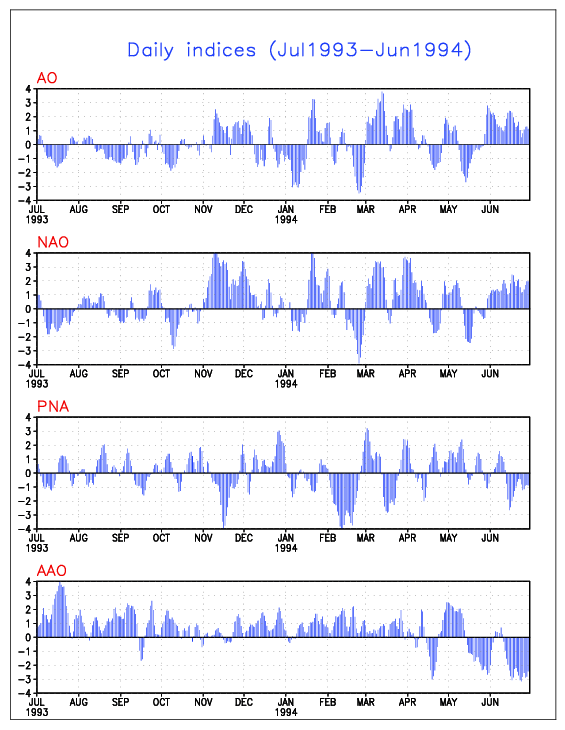
Found this interesting from my AFD in LWX...

DURING EL-NINO WINTERS...AN ACTIVE SUBTROPICAL JET BRING LOTS OF
INTERESTING WEATHER TO THE MID-ATLANTIC REGION. THE PRECIP EVENT FOR
TONIGHT FEATURING A STRONG SRN STREAM VORT MAX AND AMPLE MOISTURE
COULD BE A COMMON THREAD OF OUR WINTERTIME PRECIP EVENTS THIS COMING
WINTER. FOR NOW...THE REALLY COLD AIR CAN'T MAKE IT THIS FAR S AS
LONG AS THE UPR LOW OVER JAMES BAY STAYS WHERE IT IS. ONE COLLEAGUE
AT NCEP MENTIONED TODAY THAT THIS UPR LVL PATTERN IS SOMEWHAT
REMINICENT OF THE UPR PATTERN PREVELANT DURING THE WINTER OF
1993-94.
THE STRENGTH OF COLD AIR IS CRITICALLY DEPENDENT IN THIS
REGION ON THE SIGN OF THE NORTH ATLANTIC OSCILLATION (NAO)...WHICH
IS DIFFICULT TO PREDICT BEYOND ABOUT 2-3 WEEKS IN ADVANCE. LATEST
PROJECTIONS OF THE NAO BY NCEP ENSEMBLES SUGGEST A TREND TOWARDS A
NEGATIVE PHASE BEYOND DAY 7. THE CURRENT CDC EXPERIMENTAL WEEK TWO
(DAYS 8-14) PROJECTIONS ALSO SUGGEST A BETTER CHANCE OF COLDER TEMPS.


Can anyone discuss what that means?
0 likes   

Anonymous

#65 Postby Anonymous » Sun Nov 28, 2004 12:08 am

yoda wrote:Found this interesting from my AFD in LWX...

DURING EL-NINO WINTERS...AN ACTIVE SUBTROPICAL JET BRING LOTS OF
INTERESTING WEATHER TO THE MID-ATLANTIC REGION. THE PRECIP EVENT FOR
TONIGHT FEATURING A STRONG SRN STREAM VORT MAX AND AMPLE MOISTURE
COULD BE A COMMON THREAD OF OUR WINTERTIME PRECIP EVENTS THIS COMING
WINTER. FOR NOW...THE REALLY COLD AIR CAN'T MAKE IT THIS FAR S AS
LONG AS THE UPR LOW OVER JAMES BAY STAYS WHERE IT IS. ONE COLLEAGUE
AT NCEP MENTIONED TODAY THAT THIS UPR LVL PATTERN IS SOMEWHAT
REMINICENT OF THE UPR PATTERN PREVELANT DURING THE WINTER OF
1993-94.
THE STRENGTH OF COLD AIR IS CRITICALLY DEPENDENT IN THIS
REGION ON THE SIGN OF THE NORTH ATLANTIC OSCILLATION (NAO)...WHICH
IS DIFFICULT TO PREDICT BEYOND ABOUT 2-3 WEEKS IN ADVANCE. LATEST
PROJECTIONS OF THE NAO BY NCEP ENSEMBLES SUGGEST A TREND TOWARDS A
NEGATIVE PHASE BEYOND DAY 7. THE CURRENT CDC EXPERIMENTAL WEEK TWO
(DAYS 8-14) PROJECTIONS ALSO SUGGEST A BETTER CHANCE OF COLDER TEMPS.


Can anyone discuss what that means?


Well, in the winter of 1993-1994, Woodbridge VA saw 2 inches of snow Dec 27, 1993, then on Jan 19 we got an inch and a half of sleet and frz rain, then on Feb 9 we got slammed with 3 inches of sleet, some of which was very heavy. Then March 1-2 we got 4 inches of snow.

That was one ICY, ICY winter!! February was very cold too, local lakes and ponds had 8 inches of ice on them; folks were actually driving trucks on a pond with 8 inches of ice, I personally verified the ice thickness.

WOW, another devastating ice year this winter?

Hmmmmm....................that's great for my jebwalk!!!! :)

-Jeb
0 likes   

User avatar
wxguy25
Professional-Met
Professional-Met
Posts: 708
Joined: Wed Oct 13, 2004 4:44 pm
Location: East Central Florida
Contact:

#66 Postby wxguy25 » Sun Nov 28, 2004 1:16 am

There are some MAJOR differences between this year and 1993-94.

1993-94 featured:

North PAC SSTA configuration was different. We had a favorable warm pool in the GOA w/ the cool pool located further back to the west like 1986, 2002. This was a CLASSIC indicator of a strong Aleutian low, predominantly –EPO / +PNA pattern.

Image

http://www.longpaddock.qld.gov.au/Seaso ... 86/Nov.gif
http://www.longpaddock.qld.gov.au/Seaso ... 02/Nov.gif

Winter 1993-94 EPO verification: DEC -0.5 JAN -0.8 FEB -1.2

Image

Thus far in 2004, the warm pool has begun to push eastward however is still located near 150W longitude, and the cold pool is forming back to the west, so your still going to get the enhanced PAC JET but not to the extent of what it would be if the pattern was completely reversed w/ the cool pool east of 150W and warm water near and North of HI. Instead, I’d rather opt to classify it as a more of a VARIABLE PAC jet.

Secondly, the QBO was east—moderately so. Values generally ranged from -5 to -10 for the winter. This year, it’s struggling to decline let alone go negative. The reason why it increased westerly again in OCT is probably the result of the weak El Nino.

Thirdly, the ATC (Atlantic Thermohaline Circulation) and PDO phases are the reverse of this year, that year the ATC and PDO were finishing up the 1977-1997 warm phase. As of 1998 the phase has switched back to the cold cycle.

Lastly, the state of the ENSO was different. 1993-94 was an ENSO neutral winter following another Neutral/west winter.

2004-05 will be a weak EL NINO/West winter following a neutral East winter.

As a matter of fact the only real similarity that I can see between the two years is the position of 2004 and 1993 in their respective solar cycles. However that said, since we are approaching the solar maximum (and were in 1993-94 also) the correlation isn’t all that important.

Do I feel that 1993-94 is a plausible analog? NO
0 likes   

User avatar
Wnghs2007
Category 5
Category 5
Posts: 6836
Age: 36
Joined: Wed Mar 24, 2004 11:14 pm
Location: Gwinnett-Barrow Line; Georgia
Contact:

#67 Postby Wnghs2007 » Sun Nov 28, 2004 1:58 am

wxguy25 wrote:There are some MAJOR differences between this year and 1993-94.

1993-94 featured:

North PAC SSTA configuration was different. We had a favorable warm pool in the GOA w/ the cool pool located further back to the west like 1986, 2002. This was a CLASSIC indicator of a strong Aleutian low, predominantly –EPO / +PNA pattern.

Image

http://www.longpaddock.qld.gov.au/Seaso ... 86/Nov.gif
http://www.longpaddock.qld.gov.au/Seaso ... 02/Nov.gif

Winter 1993-94 EPO verification: DEC -0.5 JAN -0.8 FEB -1.2

Image

Thus far in 2004, the warm pool has begun to push eastward however is still located near 150W longitude, and the cold pool is forming back to the west, so your still going to get the enhanced PAC JET but not to the extent of what it would be if the pattern was completely reversed w/ the cool pool east of 150W and warm water near and North of HI. Instead, I’d rather opt to classify it as a more of a VARIABLE PAC jet.

Secondly, the QBO was east—moderately so. Values generally ranged from -5 to -10 for the winter. This year, it’s struggling to decline let alone go negative. The reason why it increased westerly again in OCT is probably the result of the weak El Nino.

Thirdly, the ATC (Atlantic Thermohaline Circulation) and PDO phases are the reverse of this year, that year the ATC and PDO were finishing up the 1977-1997 warm phase. As of 1998 the phase has switched back to the cold cycle.

Lastly, the state of the ENSO was different. 1993-94 was an ENSO neutral winter following another Neutral/west winter.

2004-05 will be a weak EL NINO/West winter following a neutral East winter.

As a matter of fact the only real similarity that I can see between the two years is the position of 2004 and 1993 in their respective solar cycles. However that said, since we are approaching the solar maximum (and were in 1993-94 also) the correlation isn’t all that important.

Do I feel that 1993-94 is a plausible analog? NO


Wow...thanks for the discussion wxguy25 :D
0 likes   

Anonymous

#68 Postby Anonymous » Sun Nov 28, 2004 3:21 pm

Great discussion, wxguy25!!!!

Alright this will be NO '93-'94.


-Jeb
0 likes   

User avatar
Wnghs2007
Category 5
Category 5
Posts: 6836
Age: 36
Joined: Wed Mar 24, 2004 11:14 pm
Location: Gwinnett-Barrow Line; Georgia
Contact:

#69 Postby Wnghs2007 » Sun Nov 28, 2004 5:34 pm

Jeb wrote:Great discussion, wxguy25!!!!

Alright this will be NO '93-'94.


-Jeb


I guess that is a good thing. :lol:
0 likes   


Return to “Winter Weather”

Who is online

Users browsing this forum: No registered users and 5 guests