Winter Weather Discussion
Moderator: S2k Moderators
Forum rules
The posts in this forum are NOT official forecast and should not be used as such. They are just the opinion of the poster and may or may not be backed by sound meteorological data. They are NOT endorsed by any professional institution or
STORM2K.
-
TeamPlayersBlue
- Category 5

- Posts: 3522
- Joined: Tue Feb 02, 2010 1:44 am
- Location: Denver/Applewood, CO
#6341 Postby TeamPlayersBlue » Wed Feb 23, 2022 3:16 pm
Was 55F at lunch here, was around 2 or 3 degrees the next day at lunch. 10F at around 8 that night. This front was a serious one.
Still 3F here currently. No wind, thank goodness!
3 likes
Personal Forecast Disclaimer:
The posts in this forum are NOT official forecast and should not be used as such. They are just the opinion of the poster and may or may not be backed by sound meteorological data. They are NOT endorsed by any professional institution or storm2k.org. For official information, please refer to the NHC and NWS products.
-
opticsguy
- S2K Supporter

- Posts: 240
- Joined: Wed Jan 05, 2011 9:27 pm
- Location: McKinney, TX
#6342 Postby opticsguy » Wed Feb 23, 2022 3:26 pm
WeatherNewbie wrote:Ntxw wrote:Probably want to avoid the bridges. DFW traffic map doesn't look so great.
we are up to 5 accidents on the bridge just outside the entrance to our neighborhood (spring valley between preston and hillcrest). i've been shaking my head at the dummies trying to zip across it as i sit here working from home in my office...
We used to live across Beltline from where Alexis drive merged on a 3-way bridge at the bottom of a hill. I could sit for hours watching cars crash into the curb or the median. Dallas would never salt that bridge for some reason
1 likes
-
Ntxw
- Storm2k Moderator

- Posts: 23341
- Joined: Wed Oct 21, 2009 6:34 pm
- Location: DFW, Texas
#6343 Postby Ntxw » Wed Feb 23, 2022 3:30 pm
WacoWx wrote:NTXW was right abt today.
Car accidents on secondary roads here in Dallas. Abrams and skillman, and then abt every 2-3 blocks another car is spun out. Rush hour is going to be a nightmare in DFW.
We've seen it over and over across Texas. It's the little drizzle light rain/fog events that gives perception of confidence to drivers. Then you mad rush them all to leave early at the same time while it's 25F. They're bad enough on a good day! You add a weather element to that...
4 likes
The above post and any post by Ntxw is NOT an official forecast and should not be used as such. It is just the opinion of the poster and may or may not be backed by sound meteorological data. It is NOT endorsed by any professional institution including Storm2k. For official information, please refer to NWS products.
Help support Storm2K!
-
WeatherNewbie
- Tropical Storm

- Posts: 235
- Joined: Mon Mar 22, 2010 3:42 pm
- Location: Richardson, Texas
#6344 Postby WeatherNewbie » Wed Feb 23, 2022 3:37 pm
opticsguy wrote:WeatherNewbie wrote:Ntxw wrote:Probably want to avoid the bridges. DFW traffic map doesn't look so great.
we are up to 5 accidents on the bridge just outside the entrance to our neighborhood (spring valley between preston and hillcrest). i've been shaking my head at the dummies trying to zip across it as i sit here working from home in my office...
We used to live across Beltline from where Alexis drive merged on a 3-way bridge at the bottom of a hill. I could sit for hours watching cars crash into the curb or the median. Dallas would never salt that bridge for some reason
i know the spot well... my wife and i walk to torchy's that way. i can see that being a big mess in this weather.
0 likes
The above post is NOT an official forecast and should not be used as such. It is just the opinion of the poster and may or may not be backed by sound meteorological data. It is NOT endorsed by any professional institution including storm2k.org. For official information, please refer to NWS products.
-
Brent
- S2K Supporter

- Posts: 38611
- Age: 37
- Joined: Sun May 16, 2004 10:30 pm
- Location: Tulsa Oklahoma
-
Contact:
#6345 Postby Brent » Wed Feb 23, 2022 3:47 pm
Definitely snowing here now. Maybe the second round can be snow

2 likes
#neversummer
-
Iceresistance
- Category 5

- Posts: 9524
- Age: 22
- Joined: Sat Oct 10, 2020 9:45 am
- Location: Tecumseh, OK/Norman, OK
#6346 Postby Iceresistance » Wed Feb 23, 2022 3:49 pm
Big snowflakes coming down at my house! 13°F
3 likes
Bill 2015 & Beta 2020
Winter 2020-2021 
All observations are in Tecumseh, OK unless otherwise noted.
Winter posts are focused mainly for Oklahoma & Texas.
Take any of my forecasts with a grain of salt, refer to the NWS, SPC, and NHC for official information
Never say
Never with weather! Because
ANYTHING is possible!
-
txtwister78
- Category 5

- Posts: 2075
- Joined: Wed Jan 30, 2019 12:56 pm
- Location: San Antonio
#6347 Postby txtwister78 » Wed Feb 23, 2022 3:49 pm
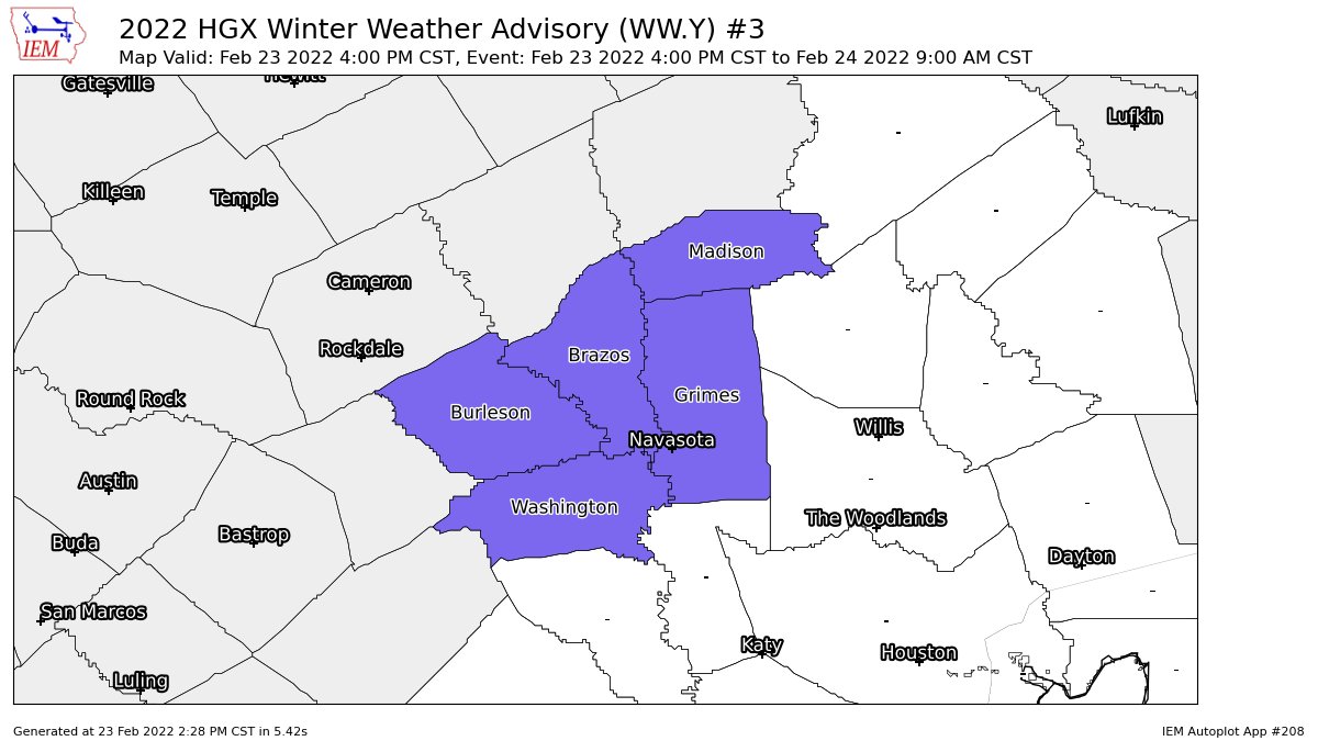
And based on those model trends as mentioned above, we now have some Houston NWS counties added to a WWA

1 likes
-
Iceresistance
- Category 5

- Posts: 9524
- Age: 22
- Joined: Sat Oct 10, 2020 9:45 am
- Location: Tecumseh, OK/Norman, OK
#6348 Postby Iceresistance » Wed Feb 23, 2022 3:52 pm
It's knocking on
Jasons2k's Door, it's only the next county away from The Woodlands, TX.
It also sounds like that Heat Miser's wall has gotten a Huge Leak.

2 likes
Bill 2015 & Beta 2020
Winter 2020-2021 
All observations are in Tecumseh, OK unless otherwise noted.
Winter posts are focused mainly for Oklahoma & Texas.
Take any of my forecasts with a grain of salt, refer to the NWS, SPC, and NHC for official information
Never say
Never with weather! Because
ANYTHING is possible!
-
Golf7270
- Tropical Depression

- Posts: 61
- Joined: Sun Dec 05, 2021 8:57 pm
- Location: Jonesboro ar
#6349 Postby Golf7270 » Wed Feb 23, 2022 3:55 pm
Heavy sleet and thunderstorm at 28 degrees in jonesboro
3 likes
-
bubba hotep
- S2K Supporter

- Posts: 5940
- Joined: Wed Dec 28, 2016 1:00 am
- Location: Collin County Texas
#6350 Postby bubba hotep » Wed Feb 23, 2022 4:18 pm
Interesting, the global models have higher qpf for most of Texas over the next 36hrs vs the hi-res models. Usually, it's the reverse.
2 likes
Winter time post are almost exclusively focused on the DFW area.
-
WacoWx
- Category 2

- Posts: 678
- Joined: Mon Dec 28, 2009 4:14 pm
- Location: NOT Waco, TX ----> Dallas, TX
#6351 Postby WacoWx » Wed Feb 23, 2022 4:26 pm
Any idea what the timing is on the next wave of energy for DFW? All radars around the state appear quiet atm. Usually I see a disturbance around west TX that provides the lift, and I do not see anything yet...unless that is it further west over in the 4 corners.
1 likes
-
Iceresistance
- Category 5

- Posts: 9524
- Age: 22
- Joined: Sat Oct 10, 2020 9:45 am
- Location: Tecumseh, OK/Norman, OK
#6352 Postby Iceresistance » Wed Feb 23, 2022 4:28 pm
WacoWx wrote:Any idea what the timing is on the next wave of energy for DFW? All radars around the state appear quiet atm. Usually I see a disturbance around west TX that provides the lift, and I do not see anything yet...unless that is it further west over in the 4 corners.
Late Tonight into Early Next Morning is when the Winter Precipitation comes into Texas & Oklahoma
1 likes
Bill 2015 & Beta 2020
Winter 2020-2021 
All observations are in Tecumseh, OK unless otherwise noted.
Winter posts are focused mainly for Oklahoma & Texas.
Take any of my forecasts with a grain of salt, refer to the NWS, SPC, and NHC for official information
Never say
Never with weather! Because
ANYTHING is possible!
-
txtwister78
- Category 5

- Posts: 2075
- Joined: Wed Jan 30, 2019 12:56 pm
- Location: San Antonio
#6353 Postby txtwister78 » Wed Feb 23, 2022 4:29 pm
bubba hotep wrote:Interesting, the global models have higher qpf for most of Texas over the next 36hrs vs the hi-res models. Usually, it's the reverse.
I think the globals were always going to be a little suspect with QPF as well when you account for their warm bias/associated temp profiles.
1 likes
-
EnnisTx
- S2K Supporter

- Posts: 896
- Joined: Sat Dec 26, 2015 4:06 pm
- Location: Albany, Texas
-
Contact:
#6354 Postby EnnisTx » Wed Feb 23, 2022 4:30 pm
Iceresistance wrote:Big snowflakes coming down at my house! 13°F
It’s not happening unless you and Brent post pictures…

0 likes
-
Snowman67
- Category 2

- Posts: 651
- Joined: Thu Dec 31, 2009 12:44 pm
- Location: Tomball, TX
#6355 Postby Snowman67 » Wed Feb 23, 2022 4:36 pm
Wouldn't surprise me at all if that WWA shifts a county or two more to the east and south...
0 likes
Any forecast I make is based on my opinion only. Please refer to the NWS or NHC for official forecasts.
-
orangeblood
- S2K Supporter

- Posts: 3842
- Joined: Tue Dec 15, 2009 6:14 pm
- Location: Fort Worth, TX
#6356 Postby orangeblood » Wed Feb 23, 2022 4:40 pm
bubba hotep wrote:Interesting, the global models have higher qpf for most of Texas over the next 36hrs vs the hi-res models. Usually, it's the reverse.
Definite trend now showing up on Hi-Res, QPF almost cut in half….much spottier too/less widespread.
0 likes
-
bubba hotep
- S2K Supporter

- Posts: 5940
- Joined: Wed Dec 28, 2016 1:00 am
- Location: Collin County Texas
#6357 Postby bubba hotep » Wed Feb 23, 2022 4:42 pm
txtwister78 wrote:bubba hotep wrote:Interesting, the global models have higher qpf for most of Texas over the next 36hrs vs the hi-res models. Usually, it's the reverse.
I think the globals were always going to be a little suspect with QPF as well when you account for their warm bias/associated temp profiles.
I was leaning more towards the global models having a better handle on the large scale isentropic lift that will be induced across Texas as the main energy ejects out into the plains over the next 24 hrs. So there really isn't much in the way of mesoscale forcing to drive precipitation. However, I've never actually looked into this setup to see if this is something that hi-res models might struggle with vs. global models.
2 likes
Winter time post are almost exclusively focused on the DFW area.
-
Iceresistance
- Category 5

- Posts: 9524
- Age: 22
- Joined: Sat Oct 10, 2020 9:45 am
- Location: Tecumseh, OK/Norman, OK
#6358 Postby Iceresistance » Wed Feb 23, 2022 4:43 pm
EnnisTx wrote:Iceresistance wrote:Big snowflakes coming down at my house! 13°F
It’s not happening unless you and Brent post pictures…

Just as you say that, the snow almost stops.
3 likes
Bill 2015 & Beta 2020
Winter 2020-2021 
All observations are in Tecumseh, OK unless otherwise noted.
Winter posts are focused mainly for Oklahoma & Texas.
Take any of my forecasts with a grain of salt, refer to the NWS, SPC, and NHC for official information
Never say
Never with weather! Because
ANYTHING is possible!
-
Brent
- S2K Supporter

- Posts: 38611
- Age: 37
- Joined: Sun May 16, 2004 10:30 pm
- Location: Tulsa Oklahoma
-
Contact:
#6359 Postby Brent » Wed Feb 23, 2022 4:48 pm
Iceresistance wrote:EnnisTx wrote:Iceresistance wrote:Big snowflakes coming down at my house! 13°F
It’s not happening unless you and Brent post pictures…

Just as you say that, the snow almost stops.
Some of it was lake effect here but yeah looks like it's about to end. Never saw any big flakes it was more a bunch of small ones
1 likes
#neversummer
-
ColdFusion
- S2K Supporter

- Posts: 445
- Joined: Wed Feb 13, 2008 3:46 pm
- Location: Addison, TX
#6360 Postby ColdFusion » Wed Feb 23, 2022 4:53 pm
orangeblood wrote:bubba hotep wrote:Interesting, the global models have higher qpf for most of Texas over the next 36hrs vs the hi-res models. Usually, it's the reverse.
Definite trend now showing up on Hi-Res, QPF almost cut in half….much spottier too/less widespread.
Man dont ruin my day off tomorrow.

0 likes
Return to “Winter Weather”
Who is online
Users browsing this forum: bevolon, Brent, bubba hotep, cheezyWXguy, Coldandsnow, ColdFusion, Cpv17, dfw_toadie, dhweather, downsouthman1, Edwards Limestone, Gotwood, gpsnowman, Haddox12, Harp.1, iorange55, Longhornmaniac8, ludosc, mmmmsnouts, Ntxw, Oilman89, Portastorm, Quixotic, Ralph's Weather, rwfromkansas, rylo7956, SnowintheFalls, South Texas Storms, sphelps8681, Stonewood Ranch, Stratton23, Tammie, Texas Snow, ThunderSleetDreams, wildbill, wxman22 and 318 guests