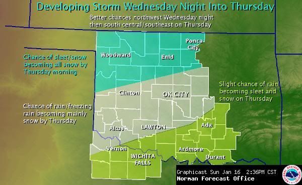
A look at today's 12z model runs concerning the winter weather potential later this week...
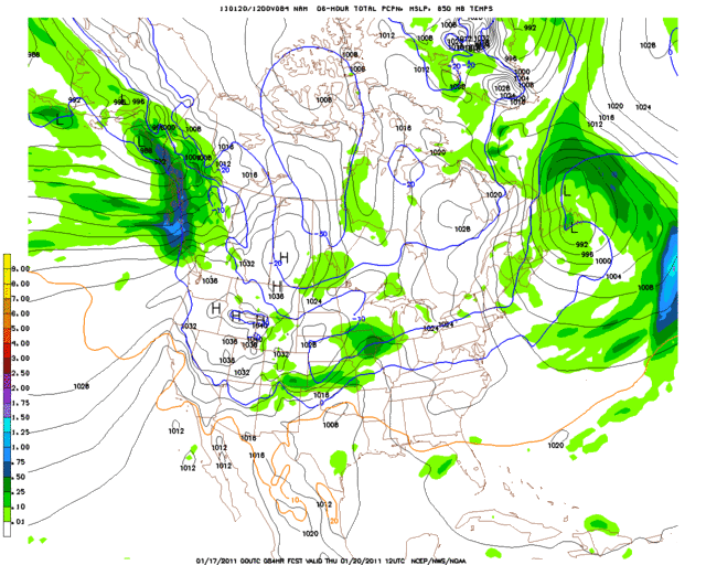
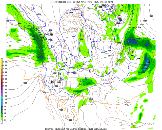
GFSThe GFS, while becoming more aggressive with each run, is still only showing a minor event as of this afternoon. In Oklahoma City it shows light rain Thursday morning changing to a very brief wintry mix (frz rain/sleet) and then ultimately becoming light snow. The total QPF for OKC is only 0.13" during the entire event, which means there would only be very light accumulations if this scenario actually played out. The GFS does show slightly higher snow totals across northern Oklahoma though, with Twisterdata.com maps indicating a large swath of 1-4" totals.
http://www.meteo.psu.edu/~gadomski/AVN_12z/f90.gifhttp://www.meteo.psu.edu/~gadomski/AVN_12z/f96.gifhttp://www.meteo.psu.edu/~gadomski/AVN_12z/f102.gifhttp://www.meteo.psu.edu/~gadomski/AVN_12z/f108.gifOKC Skew-T:
http://www.twisterdata.com/data/tmp/scr ... .5000W.pnghttp://www.twisterdata.com/data/tmp/scr ... .5000W.pnghttp://www.twisterdata.com/data/tmp/scr ... .5000W.pngAccumulated snow at hour 114:
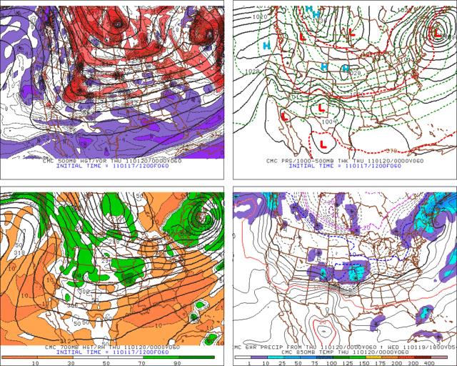
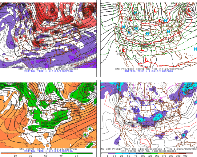
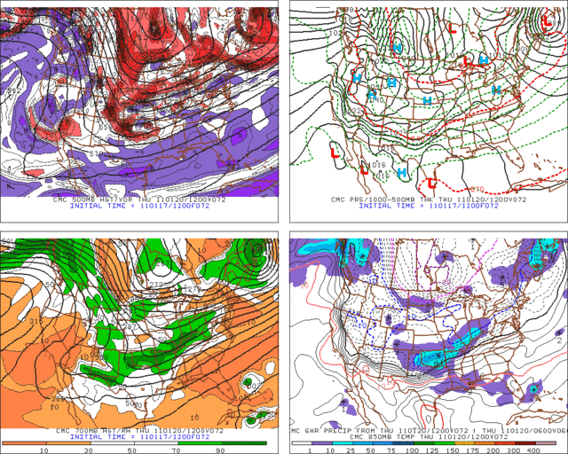
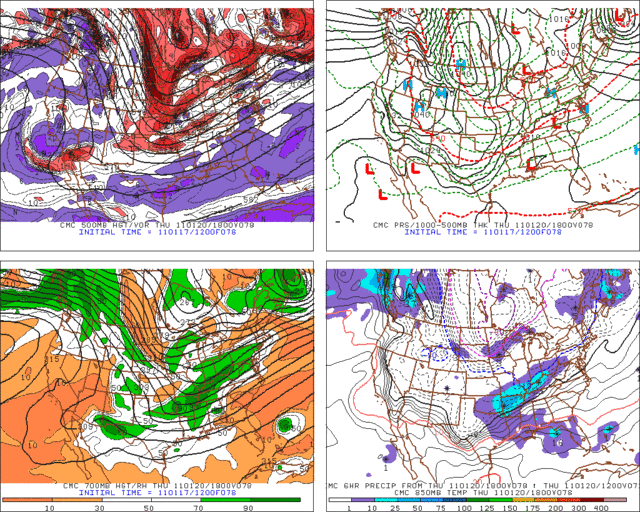
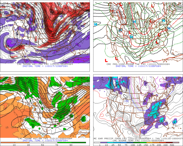
http://www.twisterdata.com/data/models/ ... URFACE.pngCMCThe latest Canadian is showing a good potential for snow across most of Oklahoma (but favoring the northern half) during the day on Thursday. It does not look like a huge event in terms of duration or magnitude, but widespread light to moderate snow accumulations would still be possible.
http://www.meteo.psu.edu/~gadomski/CMC_12z/f90.gifhttp://www.meteo.psu.edu/~gadomski/CMC_12z/f96.gifhttp://www.meteo.psu.edu/~gadomski/CMC_12z/f102.gifhttp://www.meteo.psu.edu/~gadomski/CMC_12z/f108.gifECMWFThe ECMWF is also showing a fairly minor event, with the total QPF for OKC being 0.12" (very similar to the GFS). It does show very cold air though, with surface temperatures Thursday afternoon running only in the middle 20s. 1000-500mb Thicknesses are a little high (mid 540s to start the day; upper 530s to end the day), and without skew-t data it is hard to know the precipitation type for sure. Given the very cold surface temperature though and 850mb temperatures below 0C, freezing rain seems unlikely except at the very beginning of the event. Sleet or snow would probably be the main p-type across Oklahoma City during the day if the ECMWF is correct, with only light accumulations (1" or less) given the low QPF. As with the other models, slightly higher precipitation amounts are shown across northern Oklahoma, with a QPF of 0.26" in Ponca City. This would equate to a snow total of 2-3" in that region using a ~10:1 ratio.
http://raleighwx.americanwx.com/models/ ... PUS096.gifThings to take note of...- We are still 3 to 4+ days out, and changes are still very possible (especially with the recent model uncertainty).
- The trend in some of the models has been towards higher/more widespread QPF values as the trough axis is lingering further behind the front with each new run (GFS especially). If this trend continues, then the potential for higher winter-type accumulations would exist.
- The precipitation type is not yet set in stone. This looks like it might be a tricky one, especially from 1-40 southward, and snow, sleet, freezing rain and rain are all still possibilities. Some places might even manage to see all four over the course of the event, depending on how things actually evolve.
 The posts in this forum are NOT official forecast and should not be used as such. They are just the opinion of the poster and may or may not be backed by sound meteorological data. They are NOT endorsed by any professional institution or


